AP Human Geography All Vocab
1/99
There's no tags or description
Looks like no tags are added yet.
Name | Mastery | Learn | Test | Matching | Spaced | Call with Kai |
|---|
No analytics yet
Send a link to your students to track their progress
100 Terms
Wallerstein's World Systems Theory
attempts to explain the relationship between the core and periphery countries, shows how core benefits from periphery and semi-periphery, the semi-periphery can benefit from the periphery while still benefiting the core.
Reference Map
Maps that show basic information about places. Ex: political, physical
Physical Map
Shows natural landscape features like topography (Elevation) by colors & shading
Political Map
Shows borders between governments
Thematic Maps
Show the distribution of characteristics like human activities Ex: Snowfall, Population, Stores
Clustering Data
Grouped/bunched together
Dispersed Data
Appears to be distributed over a wide area
Cartogram Map
Size of countries are distorted in size to show data differences
Choropleth Map
Map that uses shading or coloring to show data
Dot Density Map
Dots represent density of data in area
Isoline Map
Connects areas with equal data by lines/shapes
Proportional Symbol Map
Symbols vary in size to show amount of data
Map Projections
Either distorted in shape, size, distance, and direction
Mercator Projection
Shape and direction fairly accurate, distortion towards poles, used in navigation at sea
Robinson Map
Everything is distorted in small amounts (in schools)
Goode Projection
Looks like a M, continent sizes are accurate, directions and distance aren't accurate
Gall-Peters Projection
Shape of countries especially near the equator are distorted, area is accurate but not shape
Geospatial Data
all information including physical features and human activities
Geographic Information System (GIS)
a computer system for capturing, storing, checking, and displaying data related to positions on Earth's surface (data layers)
Latitude
Distance north or south of the equator
Longitude
Distance east or west of the Prime Meridian
Relative Location
where something is in relation to something else, where a place is compared to other places
Absolute Location
The exact position of a place on the earth's surface using Geographical Coordinate System
Absolute Distance
Exactly how far away something is
Relative Distance
Includes travel distance affected by road conditions, traffic, time of day
Geographic Positioning System (GPS)
Uses global network of satellites to emit radio signals to triangulate location
Remote sensing
Refers to the process of taking pictures of the Earth's surface from satellites to provide a greater understanding of the Earth's geography over large distances (aerial photography with satellites)
Spatial Information
Comes from written accounts, field observations, media reports, travel narratives, policy documents, personal interviews, landscape analysis, photographic interpretation (organizations and individuals)
Place
the specific human and physical characteristics of a location
Toponym
a place name
Census Data
An official count of a population (US is every 10 years)
Space
The extent of an area and can be in a relative and absolute sense
Distance Decay
Geographic term which describes the effect of distance on cultural or spatial interactions , shorter the distance - more likely interaction, interaction decreases as distance increases
Time-Space Compression
the increasing sense of connectivity that seems to be bringing people closer together even though their distances are the same due to improved communication, transportation, technology, reduced time for diffuse
Sustainability
the goal of the human race reaching equilibrium with the environment; meeting the needs of the present without while also leaving resources for future generations
Natural Resources
A physical material constituting part of Earth that people need and value
Environmental Determinism
how the physical environment caused/determined social development
Environmental Possibilism
the physical environment may limits some human actions, but people have the ability to adjust to their physical environment
Scale
The relationship of the size of a map to amount of area it represents on Earth (describes how "zoomed in" you are while studying a geographic trait (Global (Globalization), Regional, National, State + county, and Local) small scale=zoomed in, large scale=zoomed out
Scale of Analysis
how zoomed in or out you are when looking at geographic data (local, national, regional, global)
Region
places in the same area that share characteristics, traits, and features in common making it different from others
Formal Region
a uniform region that is based quantitative data (that can be documented or measured like language, religion, nationality, political parties, culture, physical boundaries) - all government areas are this because they share a government EX: States, Wheat Belt
Functional Region
a region based around a node or focal point - terrestrial radio broadcasts are an example of this (Radio Station Broadcast area, NYC subway)
Vernacular (Perceptual Region)
an area that shares a common qualitative characteristic, it's only a region because people believe it's a region (Ex: Midwest)
Landscape Analysis
the task of defining and describing landscapes
Cultural Ecology
the study of how humans adapt to the environment (5 too's)
Human Environment Interaction
the connection and exchange between humans and the natural world (focus on how humans influence the physical world, sustainability, pollution, environmental issues)
Scale of Inquiry
Which scale of analysis answers the question
Diffusion
movement of people, ideas, customs, and information between places
Spatial Diffusion
The spread of something over time or space. Refers to array of items on the Earth's surface
Expansion Diffusion
The spread of an idea through a population in a way that the number of those influenced becomes continuously larger
Hierarchical Diffusion
An idea spreads by passing first among the most connected individuals, then spreading to other individuals
Reverse Hierarchical Diffusion
Diffusion up a hierarchy, such as from a little city to a big one.
Contagious Diffusion
The transmission of a phenomenon through close contact with nearby places, like diseases.
Relocation Diffusion
A form of diffusion where the ideas being diffused are transmitted by their carriers as they migrate to new areas
Stimulus Diffusion
A cultural adaptation is created as a result of the introduction of a cultural trait from another place.
Diffusion Barriers
Time-distance decay, cultural barriers, physical barriers
Absolute Direction
Based on the cardinal points of North, South, East, and West
Ecumene
Where people settled on the earth
Physical Factors
People avoid areas too dry, too wet, too cold, too high
Cultural Factors
Populations will be concentrated in areas that have access to Education, health care, and entertainment opportunities
Historical Factors
certain areas where life could be sustain and lived (Areas where human flourished and survived)
Arthemetic density
the total number of objects in an area, just a calculation
Physiological Density
the number of people supported by a unit area of arable land, shows overpopulation
Agriculture Density
The ratio of the number of farmers to the amount of arable land, reflects how developed a country is
What do areas with larger populations and greater population densities have?
Greater political, economic, and social power
Political Power
Greater control over laws, larger influence
Economic Power
concentration of jobs, areas make more revenue
Social Power
Greater access to health care, better educational opportunities, greater cultural diversity
Carrying Capacity
the maximum population size of the species that the environment can sustain
Overpopulation
when there are not enough resources in an area to support a population
Age/Sex ratio
Comparison of the numbers of males and females of different ages
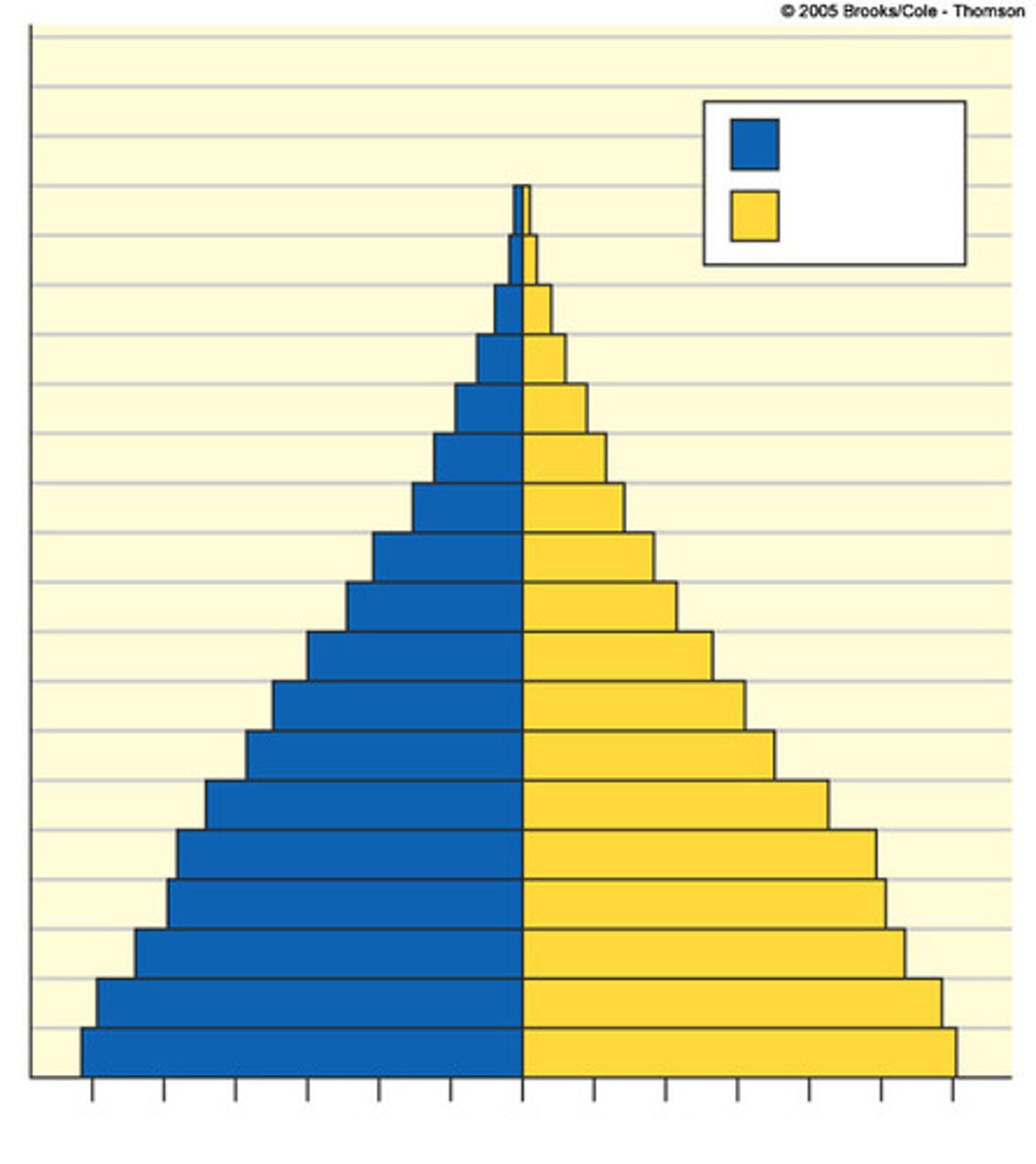
Population Pyramid
a graph of the population of an area by age and sex - when a population is growing it takes a pyramid shape
Rapid Growth Population Pyramid
Large Base, triangle Ex: Kenya
Slow Growth Population Pyramid
cylinder/bottle shaped Ex: United States
Decreasing Population Pyramid
Narrower on the bottom Italy, Japan
Demography
the study of population
Crude Birth Rate (CBR)
The number of live births per one thousand people in the population
Crude Death Rate (CDR)
The number of deaths per one thousand people in the population
Doubling time
The time period it takes for a population to double in size (70/RNI = doubling time)
Fertility
the number of live births occurring in a population
Infant Mortality Rate (IMR)
the number of children who don't survive their first year of life per 1000 live births in a country
Mortality
the number of deaths occurring in a population
Rate of Natural Increase (RNI or NIR)
A positive RNI means a population is growing and a negative RNI means a population is shrinking (birth rate - death rate)/10
Total Fertility Rate (TFR)
the average number of children a woman is predicted to have in her child bearing years (affected by: social, cultural, governments, economic factors)
Demographic Transition Model
A model of how the size of a population changes as a country develops socially and economically
Epidemiological Model
Explains how society has developed and the change in how/why people are dying as we have progressed
Stage 1: Pestilence and Famine (High CDR)
Infectious diseases are a principal causes of human deaths
Stage 2: Receding Pandemics
A pandemic is an epidemic that occurs over a wide geographic area and affects a very high proportion of the population - whole country or world wide
--improved sanitation, medicine and better nutrition
Stage 3: Degenerative and Human Created Diseases
Characterized by a decrease in infectious diseases (polio, measles) but increase in Chronic disorders associated with aging. Two especially important chronic disorders are heart disease and cancer
Stage 4: Delayed Degenerative
The major degenerative causes of death - cardiovascular diseases and cancers, but with extended life expectancy. Medicine helps make cancer spread more slowly or stop
Malthus Theory
While population increases geometrically, food supply increases arithmetically (population will increase more quickly than food supply)
Neo-Mathusian Theory
Earth's resources can only support a finite population --Pressure on scare natural resources leads to famine and war -- Advocate for contraceptive and family planning in order to keep population low and protect resources and prevent famine and war
Antinatalist policies
when a country provides incentives for people to have fewer children (sometimes including punishments) EX: China
Pronatalist Policies
when a country provides incentives for people to have more children EX: Japan
Immigration Policies
States can set up policies that make it easier or harder for people to immigrate to their territory (quotas and accepting or refusing refugees into the country)
Contraception
methods of preventing pregnancy
Ravenstein's Laws of Migration
1. Most migration is over a short distance. 2. Migration occurs in steps. 3. Long-range migrants usually move to urban areas. 4. Each migration produces a movement in the opposite direction. 5. Rural dwellers are more migratory than urban dwellers. 6. Within their own country females are more migratory than males, but males are more migratory over long distances. 7. Most migrants are adults. 8. Large towns grow more by migration than by natural increase. 9. Migration increases with economic development. 2. Migration is mostly due to economic causes.
Dependency Ratio
the ratio of the number of people not in the work force (dependents) and those who are in the work force (producers) - useful for understanding the pressure on the producers
Life Expectancy
the average number of years a person born in a country might expect to live