GE-101 Introduction to Geography - Atmospheric and Oceanic Systems
1/44
Earn XP
Description and Tags
Vocabulary based flashcards covering key terms from a GE-101 geography exam including atmospheric lifting, global winds, weather instrumentation, and oceanic cycles.
Name | Mastery | Learn | Test | Matching | Spaced | Call with Kai |
|---|
No analytics yet
Send a link to your students to track their progress
45 Terms
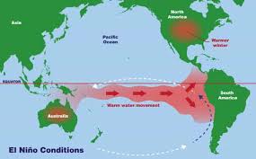
El Niño
The name given to the periodic warming of the ocean that occurs in the central and eastern Pacific, often occurring in cycles of 3 to 7 years.
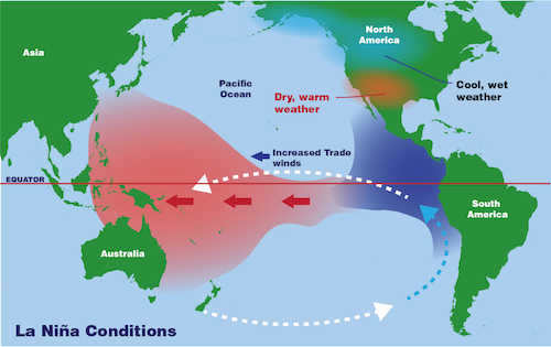
La Niña
a climate pattern characterized by cooler-than-normal sea surface temperatures in the central and eastern tropical Pacific Ocean, occurring every 2–7 years
Coriolis Effect
The phenomenon describing how Earth’s rotation deflects moving objects to the right in the Northern Hemisphere and to the left in the Southern Hemisphere.
Anemometer
A weather instrument that resembles a cup and is commonly used to measure wind speed.
Barometer
An instrument used for measuring air pressure.
Psychrometer
An instrument consisting of a wet bulb and a dry bulb thermometer used to determine atmospheric humidity.
Subsolar Point
The location where the sun's rays are perpendicular (at right angles) to the Earth's surface.
Relative humidity
The amount of water vapor in the air expressed as a percentage of the maximum amount the air can hold at a given temperature.
Jetstream
Fast-moving 'rivers' of air that travel between 120 and 240 km/h in a west-to-east direction.
Monsoons
Seasonal reversal of wind direction associated with large continents, like Asia, where wind blows from land to sea in winter and sea to land in summer.
Gulf Stream
The main oceanic current that regulates most of western Europe, providing relatively mild winters.
Intertropical Convergence Zone (ITCZ)
A belt of low pressure circling the Earth near the equator where the trade winds of the Northern and Southern Hemispheres come together.
Sublimation
The process of ice water turning directly into its gaseous form without going through a liquid phase.
Orographic precipitation
Precipitation produced when moist air is lifted as it moves over a mountain range, cooling and forming clouds.
Air pressure
The phenomenon exerted by the weight of air in all directions—down, up, and sideways.
Sea Breeze
The dominant daytime breeze in coastal areas where land heats faster than the ocean, causing air to rise on shore and creating lower pressure.
Land Breeze
The dominant nighttime breeze occurring when air above the sea is warmer than the land surface, causing air to expand and rise offshore.
Tradewinds (Easterlies)
Two belts of winds that blow almost constantly from the east towards the western directions, located north and south of the subtropical highs.
Westerlies
The dominant west-to-east motion of the atmosphere that characterizes regions on the poleward side of the subtropical highs.
Summer Solstice
Occurs every June 20 to 23 in the northern hemisphere, representing the longest day and shortest night of the year.
Winter Solstice
Occurs every December 20 to 23 in the northern hemisphere, representing the longest night and shortest day of the year.
Spring Equinox
Occurs March 20 to 23 when both hemispheres experience equal day and night lengths of 12 hours.
Autumnal Equinox
Occurs September 20 to 23 when both hemispheres experience equal day and night lengths of 12 hours.
Cyclones
Atmospheric centers characterized by low air pressure.
Insolation
Solar radiation that reaches a horizontal plane at the Earth's surface.
Doldrums
Another name for the Intertropical Convergence Zone (ITCZ).
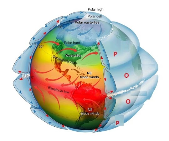
Hadley Cells
The atmospheric circulation cells labeled (O) in global circulation models.

Ferrel Cells
The atmospheric circulation cells labeled (P) in global circulation models.
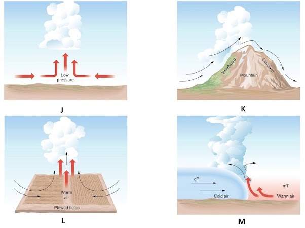
Convectional Lifting
Atmospheric lifting labeled (L) caused by unequal heating of the surface.

Frontal Lifting
Atmospheric lifting labeled (M) occurring when less dense warm air rises over denser cooler air

Convergent Lifting
Atmospheric lifting labeled (J) where air flows together from different directions and is forced upward.

Orographic Lifting
Labeled K, air forced to rise over higher elevation
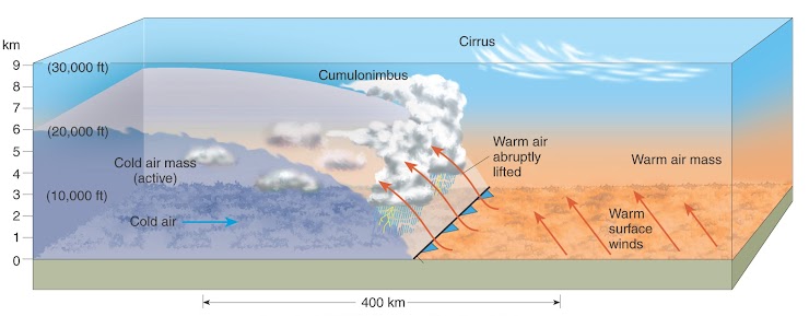
Cold Front
leading edge of a cooler, denser air mass replacing a warmer, less-dense air mass, typically moving from northwest to southeast in the Northern Hemisphere. It acts as a cold-air "bulldozer" that forces warm, moist air upward, often resulting in narrow bands of cumulus clouds, thunderstorms, and sharp, quick-moving weather changes
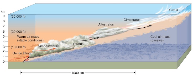
Warm Front
the leading edge of a moving, less dense warm air mass that slides up and over a retreating, colder, and denser air mass. It typically moves slower than cold fronts (approx. 12 mph) and brings gradual increases in temperature, humidity, and falling pressure

Cumulus Clouds
Labeled C, detached, low-level, fluffy cotton like
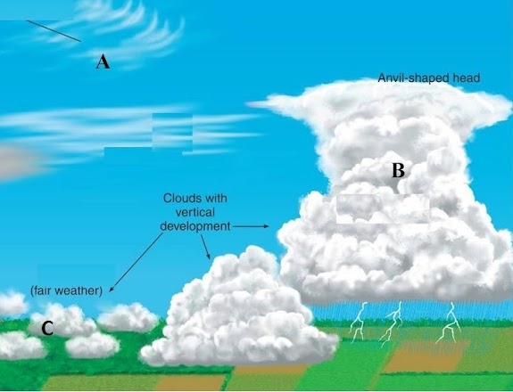
Cirrus Clouds
Labeled A, high altitude, wispy, composed of ice crystals

Cumulonimbus Clouds
Labeled B, dense, vertical, formed by water vapor, carried by buoyant air currents
Wind
The result of horizontal differences in air pressure
Air Flow
Air flows from areas of higher pressure to ares of lower pressure
Epipelagic Zone
“sunlight zone”
most solar heating, lots of temp change
surface to 200m, influenced by wind
transition layer
temp decreases rapidly
Mesopelagic Zone
“Twilight Zone”
most temp change near top
200-1000m
Bathypelagic Zone
“Midnight Zone”
no light at all, only light from animals
very little temp change
pressure: 5800 psi
Abyssopelagic Zone
“The Abyss” (no bottom)
4000-6000m
water temp near freezing
Hadalpelagic Zome
“The Trenches”
below 6000m
deepest trench: Mariana Trench >8 tsi