geography option A freshwater
1/37
Earn XP
Description and Tags
ib geo SL
Name | Mastery | Learn | Test | Matching | Spaced | Call with Kai |
|---|
No analytics yet
Send a link to your students to track their progress
38 Terms
Drainage basin
an area where every drop of water will flow downwards to a common outlet (eg. a river)
Watershed
imaginary line acting as a boundary of a drainage basin, separating it from other basin(s).
Discharge
Volume of water passing a given point over a named time
Endorheic drainage basin
A drainage area that has no outflow to the ocean and only collects inside the basin (eg. a river)
Capillary rise
The ability of a liquid to flow against gravity in narrow spaces, allowing water to transfer from groundwater up into soil moisture storage
Percolation
The slow downward movement of a liquid through a filtering porous medium
Evapotranspiration
Evaporation + Transpiration. Evaporation is the water changing from liquid to gas from oceans or lakes driven by heat from the sun. Transpiration is water that is released as water vapour by plants through their stomata.
Potential EV
the maximum amount of evapotranspiration that could occur if there is unlimited moisture available
Water runoff
occurs when water exceeds the infiltration rate (more rain than space for rain to go), and when soil is saturated (all space for rain to go has been filled)
Infiltration
The rate at which water on the ground surface enters a substance
Inputs
When water is added to a drainage basin. precipitation and interbasin transfer (flow of water or man made)
Outputs
When water has left a drainage basin (evaporation and transpiration)
Lag time
The delay between a peak precipitation event (like a heavy rainstorm) and the resulting peak discharge (highest flow rate) in a river or stream
Long lag time
-unsaturated soil
-no/little tributaries
-little rainfall
-small drainage basin
-permeable soils
-lots of vegetation
-rural
-human made dams
Short lag time
-saturated soil
-lots of tributaries (high drainage density)
-lots of intense rainfall
-urbanisation
-impermeable surfaces
-deforestation
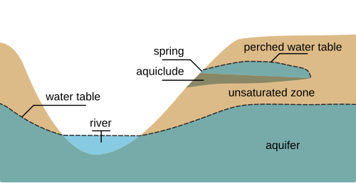
Water table
The upper surface of groundwater. It’s the boundary between the unsaturated zone (above) and the saturated zone (below). Above it, pores have air + water; below it, pores are full of water. The level below which soil and rock are saturated with water, forming the upper boundary of groundwater. It fluctuates with changes in precipitation and other factors.
Phreatic zone
The area below the water table where all pores and cracks are completely filled with water.
Aeration zone
The zone above the water table where soil pores contain both air and water. Plant roots usually grow here and where moisture is exchanged with the atmosphere.
Aquifer
An underground layer of permeable rock or sediment that stores and transmits groundwater. Wells and springs draw water from aquifers
Recharge
The process by which water enters an aquifer, mainly through rainfall infiltrating the ground and percolating downward
River bed
The bottom of the river and what the water flows over
River bank
The walls of the river which hold the river in place
River load
All the material a river carries (rocks, boulders, gravel, sand, silt, clay, etc.)
Abrasion
Caused by the river’s load scraping, grinding, and hitting the bed and banks, like sandpaper rubbing against wood, wearing away the channel to deepen and widen it over time.
River channel
The space a river flows in: the bed and the banks.
Source
Where the river begins, usually found in a highland. Eg, glaciers, heavy rainfall in high areas, springs, etc.
Mouth
Where the river ends. Where the river flows into another body of water. Usually into the sea, sometimes another river, sometimes another lake.
Attrition
The load wearing itself down. Rocks collide with each other and get smaller and rounder
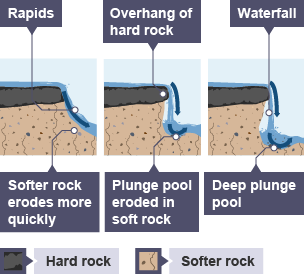
Hydraulic action
The force of the water itself eroding the river banks and bed (no rocks needed). Water hitting cracks in the rock, high speed water eg. waterfalls/rapids erode the river banks and bed.
Cavitation
Water flows very fast and pressure drops. Low pressure causes tiny, unstable bubbles to form, which suddenly implode against a river bank/bed. This releases a tiny but powerful shock.
Corrosion
Chemical erosion - water dissolves rocks (eg. limestone) and produce calcium/other ions in the water. This makes the river change pH.
Deposition
When a river drops the material it’s carrying (its load) because it loses energy. Opposite of erosion (carrying materials). It makes the ground go upwards. Low velocity increases deposition
Gradient
The slope or steepness of a river, typically calculated as the change in elevation over a certain distance. It influences river flow speed and sediment transport.
Formation of a waterfall
When a river flows from hard rock onto a softer, less resistant rock layer, causing the softer rock to erode faster
Delta
A river delta is a landform at the mouth of a river, where the river flows into a sea or lake and deposits sediment.
Eutrophication
Increased nutrients →
Rapid algae/plant growth on the top of the river →
Plants below die and decompose via bacteria →
Bacteria consume oxygen via respiration quickly→
Oxygen levels dropped, so fish etc. can’t respire bc no oxygen , hypoxic environment (dead zones)
Central pivot system
Usually used in the desert, the pivot machine waters the ground in a circular way. They do this because the sand has a lot of nutrients and can be good for crops.
Not very good because it salinizes the soil as this is in the desert so the water evaporates.