Topic #7: Overview of Urban and Regional Planning Theories and Issues, Implication to Architectural Practice
1/11
Earn XP
Description and Tags
ARPLANN3
Name | Mastery | Learn | Test | Matching | Spaced | Call with Kai |
|---|
No analytics yet
Send a link to your students to track their progress
12 Terms
William Christaller’s 1933 / Central Place Theory
The range of good and threshold population of retail shops and service establishments are the major influences in explaining the number, size and distribution patterns of settlements.
William Christaller’s 1933 / Central Place Theory
A. Weber 1929 / Least Cost Theory of Industrial Location
Factory or plant locates where transport and labor costs are at a minimum, determined by cost of distance vs. weight of raw materials, cost of labor, agglomeration and deglomeration.
A. Weber 1929 / Least Cost Theory of Industrial Location
W. Alonso’s 1964 / Theory of Land Rent : The Bid-Rent Function
The price of land and demand for land changes according to the distance from the center (CBD). The center commands the highest value of land because of its proximity to business establishments and support services as well as the market.
W. Alonso’s 1964 / Theory of Land Rent : The Bid-Rent Function
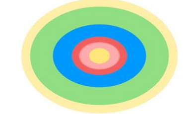
Concentric Zone Theory
Developed by Ernest Burgess in the 1920s
First model to explain and predict urban growth
Based on growth in Chicago.
1. Central Business District
2. Transition Zones
3. Working Class Zone
4. Middle Class Residences
5. Suburban Ring-Commuter Zone
Five Functional Zones
Hoyt Sector Model
Based on the mapping of eight, contrasting housing variables.
developed from Burgess’s use of simple concentric ring, to include wedges and sectors of land use.
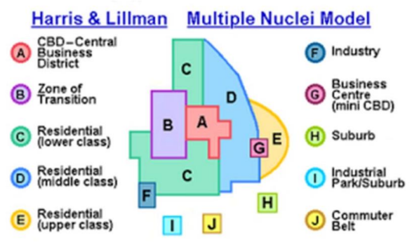
Multiple- Nuclei Model
Geographers Chauncy Harris and Edward Lillman developed the multiple –nuclei model in the 1940’s.
Suggested that functional zonation occurred around multiple centers, or nodes.
The characteristics of each node either attracted or repelled certain types of activities resulted to the existence of patchwork of land uses with its own center or nucleus
Multiple- Nuclei Model