The Water Cycle
1/46
There's no tags or description
Looks like no tags are added yet.
Name | Mastery | Learn | Test | Matching | Spaced | Call with Kai |
|---|
No analytics yet
Send a link to your students to track their progress
47 Terms
What is the water cycle?
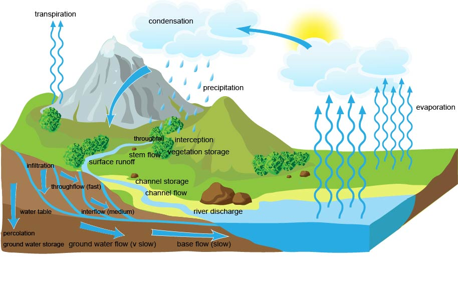
Shows how water moves around our planet in a cycle between the air, land and sea
The Drainage Basin Hydrological Cycle diagram
And again but a diff one
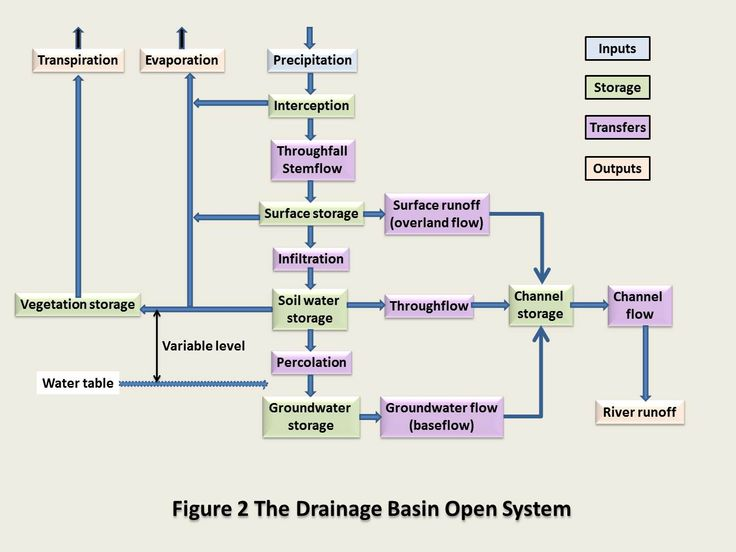
Drainage basin
The area of land drained by a river and its tributaries
Throughfall (leaf drip)
Water that drips off leaves during a rainstorm
Interception
Where precipitation is prevented from reaching the soil by leaves and branches
Runoff
All the water that flows out of a drainage basin
Infiltration
The movement of water from the surface downwards into the soil
Groundwater flow
The movement of groundwater. This is the slowest movement of water. Sometimes called baseflow.
Overland flow (surface runoff)
The movement of water over saturated or impermeable land
Throughflow
Water that moves downslope through soil
Groundwater store
Water that collects underground in pore spaces in rock
Stemflow
Water that runs down the stems and trunks of plants and trees to the ground
Percolation
The downward movement of water from soil to the rock below
Evaporation
Where water changes from a liquid to a gas
Heat from the sun drives the process
Most evaporation is from the seas and oceans
Evapotranspiration
The combination of evaporation and transpiration (water lost from plants)
Water can be lost from the soil even during dry periods as plants continue to draw water from deep below the surface with long roots
Condensation and cloud formation
Where water vapour is changed back into liquid water
Caused by a drop in temperature (dew point)
Clouds form as a result
When condensation happens near the ground, fog is formed
Precipitation
Rain
For precipitation to happen, droplets need to condense on even smaller dust, salt or smoke particles
What is the Bergeron-Findeisen process?
Where droplets of water condense around ice crystals and fall as either snow or rain
Sublimation/desublimation
Sublimation = when ice turns into water vapour (without becoming water in between stages)
Desublimation is the opposite - where water vapour becomes snowflakes or frost
Happens more at high altitude in conditions with low humidity and dry winds
Snowmelt
Contributes a lot to the global movement of water
Melting snow is responsible for feeding much of the water into some of the worlds major rivers, e.g. snowmelt from the Himalayas feeding the river Ganges
In colder climates, it can play a direct part in water availability
Cryospheric processes
Glaciers change according to the seasons
In winter, snow accumulates and the glacier advances
In summer, snow melts (ablates) and the glacier retreats
The balance is called the glacial budget
What is the water balance?
The balance between inputs and outputs of water in a river
Water budget graph
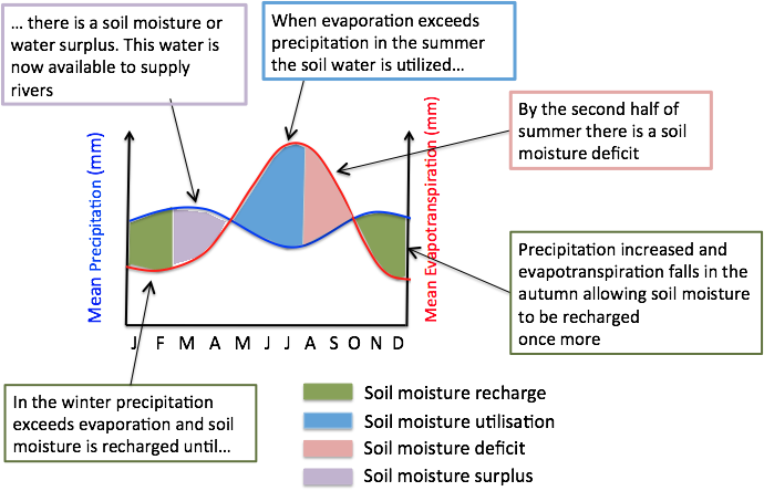
What is meant by a rivers regime?
The annual variation in a rivers discharge
What does the water budget graph show?
A rivers regime of the period of a year
What happens when precipitation exceeds evaporation?
Water surplus will occur or recharge, depending the time
What happens when evapotranspiration exceeds precipitation?
Water deficit will occur
What is the water balance equation?
precipitation = streamflow + evapotranspiration ± changes in storage
What is a hydrograph?
A graph that shows how the water flow in a drainage basin (particularly river runoff) responds to a period of rain
What is river discharge?
The volume of water which flows through it in a given time. It is usually measured in cubic metres per second (cumecs).
How do you measure the river discharge?
Calculate the velocity of the water passing by
Calculate the cross-sectional area of the river
Discharge = velocity x cross-sectional area
Draw and label a flood hydrograph
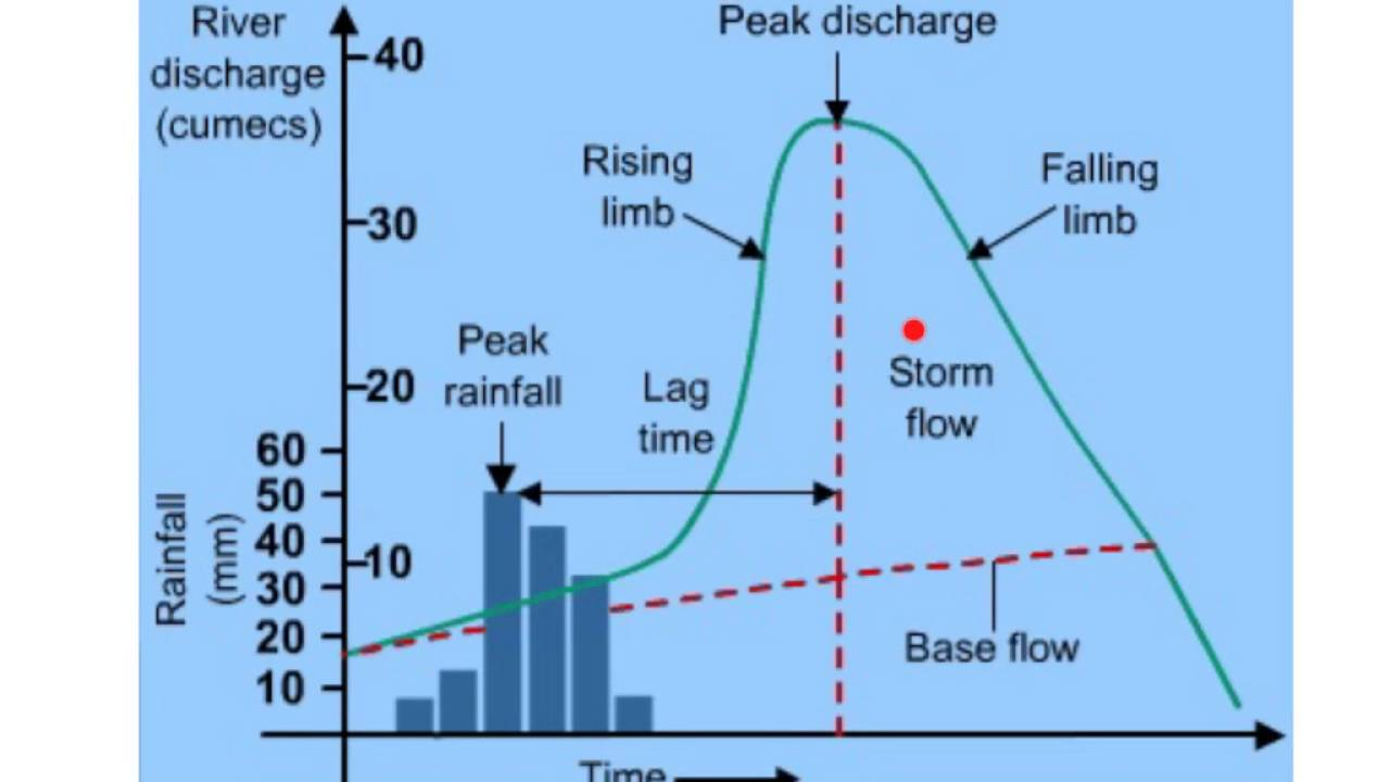
Define lag time
The time between peak rainfall and peak discharge
Factors that affect the shape of hydrographs: Precipitation
The most important factors controlling infiltration are the amount and characteristics (intensity and duration) of precipitation that falls as rain or snow
Factors that affect the shape of hydrographs: Soil characteristics
Some soils, such as clays, absorb less water at a slower rate than sandy soils. Soils absorbing less water result in more overland flow into streams.
Factors that affect the shape of hydrographs: Soil saturation
As with a wet sponge, soil already saturated from previous rainfall (antecedent rainfall) cannot absorb much more. Thus more rainfall will become overland flow.
Factors that affect the shape of hydrographs: Land cover
Some land covers have a great impact on infiltration and overland flow. Vegetation can slow the movement of surface flow, allowing more time for it to seep into the ground. Impervious surfaces, such as parking areas, roads and urban developments act as a “fast lane” for rainfall - taking water into storm drains that drain directly into streams. Agriculture and the tillage of land also change the infiltration patterns of a landscape.
Factors that affect the shape of hydrographs: Slope of the land
Water falling on steeply sloped land runs off more quickly and infiltrates less than water falling on flat land
Factors that affect the shape of hydrographs: Evapotranspiration
Some infiltration stays near the land surface, which is where plants put down their roots. Plants need this shallow groundwater to grow and, by the process of evapotranspiration, water is moved back into the atmosphere.
Factors that affect the shape of hydrographs: Antecedent rainfall
Rain falling on a ground surface that is already satured will produce a steep rising limb and a shorter lag time
Factors that affect the shape of hydrographs: Snowmelt
Large amounts of water are released, greatly and rapidly increasing discharge, especially if the ground surface is still frozen since this reduces infiltration
Factors that affect the shape of hydrographs: Vegetation
In summer, deciduous tress have more leaves and so interception is higher, discharge is lower and lag times are longer
Factors that affect the shape of hydrographs: Basin shape
Water takes less time to reach the river in a circular basin than an elongated one
Factors that affect the shape of hydrographs: Slope
In steep-sided drainage basins, water gets to the river more quickly than in an area of gentle slopes
Factors that affect the shape of hydrographs: Geology
Permeable rocks allow percolation to occur, which slows down the rate of transfer of water to the river. Impermeable rocks allow less percolation and have greater amounts of overland flow - hence greater discharge and shorter lag times.
Factors that affect the shape of hydrographs: Urban growth
Impermeable roofs and roads are shaped in such a way as to get rid of water quickly. When combined with a dense network of drains, this means that water gets to the river very quickly, reducing lag time and increase discharge.