Ground models [Lecture 5]
1/38
There's no tags or description
Looks like no tags are added yet.
Name | Mastery | Learn | Test | Matching | Spaced | Call with Kai |
|---|
No analytics yet
Send a link to your students to track their progress
39 Terms
Tectonic processes consequences
rock folding
rock fracture
uplift
subsidence
Joints
rock fracture with no movement
Formation of joints
tectonic stressing
systems = group of parallel joints
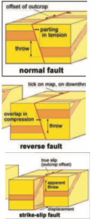
Faults
rock fractures with displacement → horizontal offset followed by erosion
Throw
vertical component of displacement
Types of faults
Normal
Reverse
Strike-slip
Dip
Faut angle from horizontal
Slip
Displacement
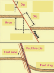
Issues with faults
Shear strength along fault reduced
Material in fault zone can be more compressible than in intact rock
Can cause stability problems
Can find fault breccia = coarse angular broken rock debris in zone (0.1–100 m wide) along a fault (commonly zone of enhanced groundwater flow)
Loose material in fault zone → cause caving in tunnels or reduce stability on surface
Fractured rock is conductive to water → contaminated water can get an easy pathway along faults
Crossrail (tunnelling) hazards identified
ground water
mixed face conditions
hard strata
aggressive ground and groundwater affecting durability
obstructions (deep piles and foundations)
abrasive ground (flint)
unexploded ordinance
Crossrail (tunnelling) hazards experienced
ground water
mixed face conditions → instability of ground
obstructions → borehole casigs
Common ground profile in London
Bedding planes
thin bands of shale / clay between units of stronger rock
boundaries between individual beds of sediment
Folds
strata bent or buckled into folds
form due to forces tangential or radial to earth’s surface
anticlines & synclines
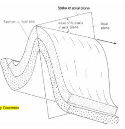
Anticline & syncline diagram
Syncline trough
Anticline crest
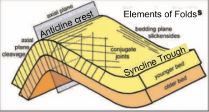
Strike & dip/rake of an anticline
Unconformity
plane or break between two sequences of rocks with different dips
Disconformity
unconformity between parallel layers of sedimentary rocks which represents a period of erosion or non-deposition
Nonconformity
unconformity between parallel layers of sedimentary rock and metamorphic / igneous rock which represents a period of erosion or non-deposition ➞ (same as nonconformity but with metamorphic or igneous rocks)
Angular unconformity
horizontal parallel strata of sedimentary rock are deposited on tilted and eroded layers of sedimentary rock
period of earth movement between times of deposition
major structural break → older rocks more solid
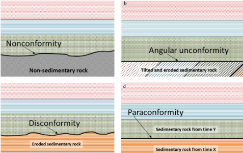
Paraconformity
horizontal parallel strata of sedimentary rocks without erosion
Strike
direction of a horizontal line on a dipping surface (angle relative to north)
Dip
angle in degrees below the horizontal relative to strike
Apparent dip
dip not measured in vertical plane perpendicular to strike line
Importance of geological structures
influence the original location of deposits and modifies shape of previously formed deposits
Faults and joints may contain mineral deposits = where faults were used to conduct magma
Joints generated by folding and faulting divide rock into blocks ➞ support may be required to prevent excavation collapse
Joints and faults provide pathways for water movement
Gaining an understanding of structure helps predict geology and enables engineering solutions to be found
Distribution of rock types and their properties are influenced by structure
Structures can link to geological hazards
Need for ground investigation
assesses ground conditions prior to starting a construction project
Include:
Suitability of the site for the proposed project
Site conditions and ground properties
Potential geotechnical/geological issues
Ground characterisation
Stages of ground investigation
Initial stage
Desk study of available data
Walkover survey and visual assessment
Preliminary report and scope of works
Main stage
Field work (geological mapping, geophysics, test pits, boreholes/coring)
Laboratory testing (soils and rocks)
Final report
Monitoring
Trial pits
cheapest method of shallow exploration
dug w/ site excavator w/ backhoe
2-5 m deep
useful where there are variable man-made fills
can be used to look at material that has slipped to identify shear surfaces
Boreholes
extract a length of soil and/or rock from the earth
overall soil/rock can be broken during the process of extraction or kept intact
samples are examined either on site or back in the laboratory
further characterisation tests can also be performed
Light percussion drilling (for soil) repeatedly drop a steel shell
➞ Possible to add an auger drill (but this will disturb the soil)
Rotary coring = rotary drive applied with downward force
➞ air / water / bentonite pumped down
➞ drill can be diamond tipped
3 distinctive characteristics in description of rocks
MATERIAL CHARACTERISTICS
those free from discontinuities
Strength, bedding/layering, colour etc and name
DISCONTINUITY CHARACTERISTICS
those of bedding, jointing & shear
Orientation, spacing, roughness, strength etc
MASS CHARACTERISTICS
rock material + rock discontinuities = Rock mass
overall structure (particularly discontinuities)
Fracture state (TCR, SCR, RQD, FI)
Types of fractures in cores
joints
mechanical breaks
rubble zones
Range of defects
heavy (weak) - moderate (strong) - minor (strong)
RQD
Rock quality designation
RQD > 70 = sound rock
RQD = sum of core lengths > 10 cm *100 / borehole length
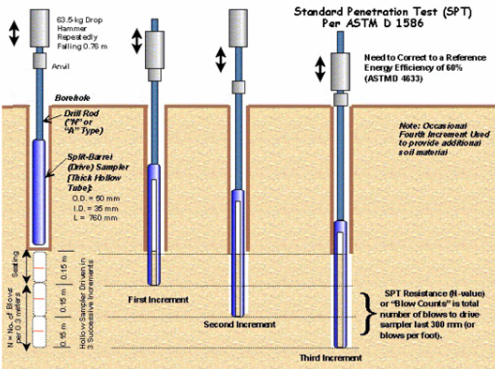
Standard penetration test SPT
Drop hammer repeatedly
SPT resistance = total number of blows to drive sampler last 300mm
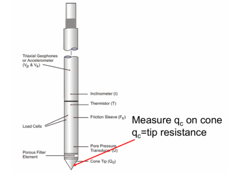
Cone penetration test
In-situ test: wide use on and offshore
Cone pushed into ground at a constant rate
Electronic transducers record force at tip & drag force on short sleeve → tip force / A = tip resistance → sleeve force / S = sleeve friction
Can be related to a wide range of geotechnical parameters through empirical relationships
porous element allows water flow & water pressure measurement
Geophysics
Non intrusive
Infer ground properties from seismic wave speed or electrical resistance
Electromagnetic surveys
Ground penetrating radar
Electrical surveys (resistivity / conductivity)
Magnetic surveys
Seismic surveys
Groundwater test
Packer test → measures local permeability of rock and aquifer properties between two packer seals in a borehole
New tools
Fibre optics
Distributed Temperature Sensing (DTS)
Distributed Temperature and Strain Sensing (DTSS)
Distributed Acoustic Sensing (DAS)
= various types of fibre optic sensing technologies which use the physical properties of light as it travels along a fibre to detect changes in temperature, strain, vibration (acoustics) and other parameters
InSAR
allows measurement of ground deformation by detecting the phase differences between at least two SAR images
Synthetic aperture radar (SAR) = active data collection where an instrument sends out a pulse of energy and then records the amount of that energy reflected back after it interacts with Earth
Example:
Impact measured by InSAR of the dewatering necessary for Crossrail’s construction in East London around the Limmo peninsula
Robots
light detection and ranging
can generate 3D images
Drones / UAVS (Unmanned aerial vehicle)
Can equip UAVs with
Digital cameras
Thermal detectors
Multispectral cameras
LiDAR
ODS
Ordinance Survey Digimap collection
borehole logs
geological maps (deposits and elevation contours)