contemporary urban environments
1/120
There's no tags or description
Looks like no tags are added yet.
Name | Mastery | Learn | Test | Matching | Spaced | Call with Kai |
|---|
No analytics yet
Send a link to your students to track their progress
121 Terms
what is urban growth?
the increase in the total population of a town or city.
what is urbanisation?
the increase in the proportion of the population living in an urban area.
what is a megacity?
metropolitan area with a total population in excess of 10 million people. a megacity can be a single metropolitan area or two or more metropolitan areas that converge upon one another.
what is urban sprawl?
the spread of an urban area into the surrounding countryside.
what is a world city?
a city that acts as a major centre for finance, trade, business, politics, culture, science information gathering and diffusion, publishing and mass media, and all the associated activities- serving not just a country or a region but the whole world.
what is the difference between urbanisation and urban growth?
urban growth is an increase in the population in a town/ city but urbanisation is an increase in the proportion of the population.
what are the causes of urbanisation?
natural population growth- urban areas have relatively young age profiles, so many people are in their fertile years therefore natural increase will be higher in cities than surrounding rural areas.
rural to urban migration- there are push factors away from rural areas and pull factors towards urban areas.
what are the push/ pull factors causing migration?
push factors: poor education, natural disasters, disease, may be far from family, mainly agricultural jobs= low income.
pull factors: improved social life as there are more activities, better job opportunities = higher pay, better healthcare, better education, more transport and infrastructure.
how have global patterns of urbanisation changed since 1945?
world urban population has increased by over 3 billion
largest increase has been in Asia where the urban population has increased by around 750 million.
urban population of africa has only slightly increased, but it is predicted to double by 2050.
how has the location of the world’s largest cities changed since 1970?
in 1970, there were very little megacities, predominantly only in asia and north/ south america, such as new york, tokyo and osaka.
there has been a large increase in the amount of megacities since 1970, as there are now megacities in africa and europe.
theres also been a large increase in the amount of cities with a population of between 1 and 5 million, particulary in europe.
what are the consequences of urban sprawl?
causes more roads and infrastructure to be built, which is economically inefficient to service, as they are low density rural areas not compact urban areas.
wildlife habitat loss
much more commuting from suburbs= traffic congestion increase, fuel consumption increase.
what are the consequences of urbanisation and urban growth? how do they affect the lived experience of urban residents?
shortage of affordable housing in higher income cities- can lead to a dramatic increase in both house prices and rental costs.
lack of urban services and waste disposal- maintenance of infrastructure is limited= traffic congestion, polluted water sources, flooding, rapid spread of disease.
unemployment and underemployment- many young people move to cities= high pressure to create sufficient jobs.
transport issues- process of urbanisation can lead to increased traffic in cities= more congestion and pollution which damages human health and wastes billions of pounds in lost productivity.
what is underemployment?
a situation in which a person is not doing work that makes full use of their skills and abilities.
what are the characteristics of megacities?
they offer an expensive range of social series: health, welfare, education
the environmental and planning impact of housing and infrastructure for dense populations is concentrated in one area
they provide large and diverse employment opportunities
they exist as centres for innovation.
what issues do megacities have?
most megacities are world capitals e.g London but some unexpected cities are forecasted to become megacities e.g chongqing
shanghai has the highest cancer mortality rate in the whole of china due to pollution.
there are higher rates of depression and anxiety for people who live in cities.
what factors lead to urban growth?
economic: cost of land, structural job changes, new employment opportunities, industrialisation, affordable housing, potential for earning money in the informal sector
social: geographical and social mobility, rural to urban migration, concentration in socio-cultural groups, access to social participation and diversity.
technological: more developed infrastructure, better connectivity, attraction of digital business.
political: regeneration schemes, re-imaging, planning decisions making urban areas more attractive places to live
demographic: population growth, attraction of urban areas to young, mobile populations
which factors causing urban growth are most associated to shanghai?
social- shanghai has more than 100,000 graduates per year from 60 higher education institutions. over ¼ of the city’s labour force has a college education, which is added to each year by overseas workers and students.
economic- there is a line of production centres west of shanghai which supports shanghai’s export orientated economy.
1984 chinese government set up shanghai as one of 14 open cities which established economic and technological zones causing inward investment.
what are the characteristics of world cities?
variety of international financial services including insurance, real estate, banking, accountancy and marketing
centres of media and communications for global networks
headquarters of multi national corporations
domination of trade and economy of a large surrounding area
considerable decision making power at a global level
high proportion of residents employed in the services information sectors
what is the difference between a megacity and a world city?
megacities have a population exceeding 10 million. world cities may not have a large population but they are important globally.
why are world cities so important to the world economy?
they are often hubs for finance, innovation and trade
they have a skilled labour force
why is london a world city?
finance- businesses thrive, 40% of the world’s foreign equities are traded here and over 30% of the world’s currency exchanges take place in London.
education- home to some of the world’s top universities e.g the imperial, oxford, cambridge
trade- london is a dominant global financial centre. time zone allows contact with asian markets in the morning and american markets in the afternoon.
entertainment- 300 theatres, 12,000 resturaunts, 500 cinemas, 240 museums and galleries.
media- home of the bbc which is important to uk’s culture and creative economy
what is suburbanisation?
the outward growth of people, services and employment towards the edges of an urban area.
what is the purpose of a green belt? where are they located?
green belt is to prevent urban sprawl by keeping land ‘permanently open’
green belt land is located around the rural- urban fringe to stop suburbs from expanding
what evidence is there of suburbanisation is there in guildford?
development of onslow village- has a small village centre, 3 primary schools and is located between the A3 and A31.
development of park barn- has kings college secondary school and a social housing estate.
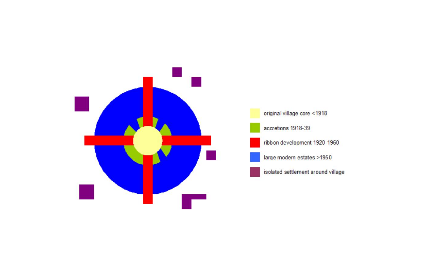
how have british cities developed due to suburbanisation?
old core
zone in transistion
victorian growth
1920-1939 growth- growth along arterial roads/ railway lines, ribbon development, few planning laws
post 1945 growth- 1947 town + country planning act, green belt introduced to halt urban sprawl, post 1950 suburbanisation more controlled
rural-urban fringe- increased demand for private ownership, large scale construction of housing on fringe
what are the causes of suburbanisation? identify the push and pull factors.
push- higher crime rates, more expensive and small houses, not a lot of space, congestion
pull- good transport links to city, more space, bigger houses built, more peaceful, live amongst leisure facilities, work less hours, earn more money, more companies
what are the consequences of suburbanisation?
social:
suburbanisation of jobs leads to decreased employment opportunities, leading to increased unemployment, increasing poverty
increasing employment decentralisation
increase in size of city as demand for low density housing increases
economic
increased vacant and derelict buildings may be dangerous and/or unsightly and may deter new inward investment
increasing price of land
environmental:
increase in air pollution
increase in outer city traffic
increasing pressure on green belt
what are the characteristics of the residents of surbiton?
surbiton is a suburban area in south west london
population of 10,600
over half the population have level 4 qualifications- more job opportunities as they have a skilled workforce (explains why many people are employed as professionals and managers)
what are the causes of suburbanisation in surbiton?
large variety of shops
close to main roads e.g A3
fastest trains reach london waterloo within 18 minutes
variety of good housing
good state schools
what are the effects of suburbanisation in surbiton?
house prices have soared- average house price is nearly £700,000
70% of houses own at least one car= congestion
located in london travel zone 6 making it expensive to commute- causes people to drive to work (40% of residents drive to work) = increases air pollution and congestion
what strategies have been used to manage problems caused by suburbanisation in surbiton?
secure bike storage
currently a campaign to get surbiton into zone 5- cheaper to commute using the train #
surbiton neighbourhood committee- locals have more of a say
improvement strategy for surbiton town centre- launced in september 2009, set delivery times for shops, new access road to station, widening roads.
what is counter urbanisation?
population movement from large urban areas to smaller urban settlements and rural areas
what is a suburbanised village?
a small settlement in which most the workers commute to work in urban areas and are said to have “urban values”, so they are not primarily interested in the rural economy e.g cranleigh
what are the causes of counter urbanisation?
increase in the use of a commuter railway stations in the area, including car parking for commuters
increased value of houses in the area
construction of more executive housing in the area, often newly designated building land, following the demolition of old properties
what are the socio economic groups of people most likely to counter urbanise?
out migration of young village born adults seeking education and employment opportunities elsewhere
decline in elderly population through deaths
in-migration of young to middle aged married couples with children
what type of rural settlement would attract people to counter urbanise?
extreme rural areas
suburbanised villaged
linear developments
hudsons model of a suburbanised village
what are the characteristics of a suburbanised village? how do they differ to an original village?
new, mainly detached or semi detached, renovated barns, expensive planned estates. original would have detached stone built or thatch roofs, some barns
professional/executive commuters, wealthy young families or retired. original would have farming and other primary jobs, labouring or manual jobs.
decline is bus services as most families have at least one car. original would rely on bus services and some cars
more shops, enlarged schools, modern public houses, restaurants. original would have a village shop, small junior school, village hall
local community swamped, village may be deserted by day. original would have a small close knit community
what are the consequences of counter urbanisation?
rise in house prices
environmental pollution
social conflict
increase in traffic
increased flood potential
loss of farmland/ green field sites
why has cranleigh become a suburbanised village?
it’s a place for commuters to live as it’s only 10 miles from guildford, where there are trains to both Portsmouth and london.
what evidence does cranleigh have of counter urbanisation?
house prices are steadily increasing as it is a popular area to live ( average house price is £679,000, has increased by 10.1% from 2021)
majority of residents are families ( single family household makes up 60% of population)
frequent bus services (around every 1-2 hours) to afew places e.g guildford and shalford railway station but only 1% of people take the bus
has cranleigh medical practice, little manor service station, mechanical engineering service
village hall, tennis courts, a community centre - all places for social events
26 sites of nature conservation importance
what is de-industrialisation?
the long term decline of a country’s manufacturing and heavy industry.
what are the three main factors that caused de-industrialisation?
competition from abroad- particularly the rapidly industrialising countries of the time such as taiwan, south korea, india and china
reduced demand for traditional products as new materials and technologies have been developed
mechanisation- most firms can produce their goods more cheaply using machines rather than people.
what are the impacts of de-industrialisation? (s, ec, en)
economic: loss of jobs and personal disposable incomes, loss of tax income to the local authority and potential decline in services, increase in demand for state benefits
social: increase in unemployment, higher levels of deprivation, higher levels of crime
environmental: derelict land and buildings, long term pollution of land from “dirty” industries e.g dye works as there is no money for land remediation, some positives like a reduction of noise, land and water pollution
what is the “inner city spiral of decline”? how does this relate to detroit?
old factories close → land becomes derelict → jobs lost → people leave the inner city → fewer services needed, shops and schools close → more jobs lost → more people leave → people who stay are usually elderly or low income groups → little money put into area so it becomes run down → more crime and vandalism → quality of life gets worse
detroit went from being world’s 5th largest city in 1950, to being the 23rd largest city in 2019
there was a lack of diversity in industry (only automotive like ford motors) and outsourcing began- jobs left detroit
128 m2 of abandoned land
how has manufacturing employment changed in the uk?
number of manufacturing employees have steadily decreased between 1978 and 2015
between 1980 and 1985 over 1 million employees were lost
60.4% decrease in manufacturing employment between 1978 and 2015
what is decentralisation?
the process of redistributing people, functions or power away from the centre to the periphery.
what examples are there of decentralisation in guildford?
surrey sports park
surrey research park
what factors have affected decentralisation?
shopping centres
increased car ownership and use of private car
relaxing of planning regulations
what is urban form?
urban form is the physical characteristics of built-up areas including the shape, size, density, and make up or configuration of settlements.
what is urban morphology?
the spatial structure and organisation of an urban area
What physical and human factors were relevant in the siting of towns and cities?
physical:
streams and rivers
climate
resources (mining)
height of land
human:
airports/ transport
employment
government policy
What is the main factor affecting land-use?
the main factor affecting land use is land value, which is traditionally higher in the centre of a city as it has a high level of accessibility.
what is the PLVI?
point with the highest land value. land prices decline in line with the theory of distance of decay.
What are the main land-use zones in cities? Where are they located, what is in each zone and why?
CBD (central business district)- in the centre of the city and has easy access, many business are here.
Inner city- area of old housing and a light manufacturing industry
residential- suburbs and outer city- consists of housing from a range of periods
Green areas- district of city, dotted throughout and urban area
out of town retail developments- originally developed by large supermarkets
business or science parks- edge of urban areas, good access to major roads
industry- manufacturing industries often requires large areas of land, tend to locate towards edge of cities
informal settlements- edges, slums/ shanty towns
what is the bid-rent theory?
the location of urban land uses is determined by the willingness to pay high prices for central locations and reliance on accessibility.
what factors will cause urban form to change over time?
population- globalisation has increased migration. flows of people are difficult to predict and manage which may result in shortfalls of housing, schools, health services etc…
environment- example is established infrastructure such as sewage systems need to keep pace with population change
economy- industry tends to locate in centres of population. industries have followed people to suburbs.
technology- example is some industries being pulled towards the ‘hardware’ of wired networks or data and processing hubs where there is high speed access to the internet and a convergence of new technologies
policies- government policies affect housing, planning and transport
describe the urban form of mumabai
densely populated- 27,000 people per square km, mumbai crams more than 12 mil people onto an area of just 438km2
CBD located in south of city and is 2-3km wide, suburbs is large area north of city, port is on south east coast of city
CBD dominated by skyscrapers and shopping areas e.g colaba causeway corner meets the need of the growing middle class
huge numbers live in poverty and city’s growth is largely unsustainable- 50% of people live in shanti towns
richest city in india and is home to bollywood
very diverse, 1000 new migrants a day, several languages spoken including marathi, many faiths practiced
describe the urban form of los angeles
contained by san gabriel mountains + pacific ocean on south coast
large city so population density is relatively low- 3,275 people per square km
highest income areas= hollywood, beverly hills, malibu
poorest district is watts which is dominated by african americans
major road routes run throughout the city
largely white middle class moved to la to escape the problems of the big industrial cities e.g chicago
mexican hispanics are the largest ethnic group
distinctive ethnic enclaves around downtown area e.g china town and little italy
describe london’s urban form
population of almost 9 million
large city with many zones of transport connecting city together
4,542 people per square km
surrounded by the M25
river thames runs through central london- tourist attraction and provides water for the city
multicultural city- many international and national migrants and enclaves e.g brick lane and bangladeshi community
banking and finance e.g canary wharf
what is town centre mixed developments?
redeveloping town centres with a combination of residential, commercial, institutional or industrial uses. these functions are designed to be physically and functionally integrated with free flowing pedestrian access
what is a cultural and heritage quarter?
to promote growth in cities many UK cities have developed cultural and heritage areas or quarters. these focus on cultural or heritage themes e.g arts and the creative industries in order to regenerate them e.g manchester northern quarter
what is a fortress landscape?
city developments that integrate greater security into the design of the building or landscape
what is an edge city?
self contained settlements with a concentration of business, shopping and entertainment outside the traditional CBD
what are gentrified inner areas?
the process of renewal and rebuilding accompanying the influx of middle-class or affluent people into deteriorating areas that often displace poorer residents
portland road
south end of street = upper class , north end = working class council flats
middle classes mainly won housing battles so working class were pushed out
there is a large division between north and south, there are physical boundaries put in place which gave south a sense of security
portland arms transformed into a high end beauty bar, and 129 portland road used to be a dairy but now sells expensive art pieces. only appeals to upper class.
what is a post modern city?
an urban form associated with changes in urban structure, architectural design and planning and reflects the changed social and economic conditions of the late twentieth century in some western cities
compare the characteristics of a modern city with a post modern city
modern:
dominant commercial centre and steady decline in land values away from centre
landscape is dominated by functional architecture
industrial economy focusing on mass production
cities planned in totality rather than smaller sections
urban open spaces planned for social needs
divisions of class found within city
post-modern:
multi-nodal structure (mixed use developments)
architecture is more of an expression of art than function
service sector based economy that focuses on niche markets
cities planned in fragments, focusing on aesthetic needs rather than social needs
ethnic diversity —> high fragmented culturally with a high degree of social polarisation in some areas
mumbai case study
indias largest city with a population estimated to be in excess of 25 million
financial and commerical centre of india and is home to bollywood
city’s status was changed due to high rise modern architecture, bombay stock exchange, tarred roads and a boom in manufacturing and services
2015 accounted for 33% of India’s income tax and 40% of foreign trade
is a megacity and has highest population density of any city in the world, population has doubled since 1991 due to an influx of migrants
diverse population- 16 languages spoken here
65,000 residents per square miles with extreme congestion in southern part of city.
over half the city lives in slums- extremely over crowded areas with no privacy, lack of sanitation and housing made of poor materials
mumbais transport system is vast and affordable- 50% of commuters choose to use public transport
60% of mumbaikars live in slums, average indian would need to work for three centuries to afford a luxury home in mumbai
lots of segregation- muslims make up 20% of population and are limited to certain zones. muslim and dalit neighbourhoods have 10% less access to piped water and 50% fewer secondary schools.
what is a micro-climate
small scale variations in temperature , precipitation, humidity, wind speed and evaporation that occur in a particular environment such as an urban area
what are the factors affecting micro-climates?
dark surfaces absorb heat
traffic congestion —> emits heat
air conditioners pump waste heat into the air
urban canyons formed between tall buildings, trapping heat at street level
how are rural and urban climates different?
rural climates are usually lower than urban climates
what is the urban climate dome?
where cities create their own climatic dome with distinctive temperature ranges, precipitation generation and patterns, humidity, wind speeds and visibility
what is albedo, which surfaces have the lowest and highest albedo?
the reflectivity of a surface. it is the ratio between the amount of incoming isolation and the amount of energy reflected back into the atmosphere. light surfaces reflect more than dark surfaces so have a greater albedo.
why is urban drainage an issue?
urban precipitation falls in greater amounts and with greater intensity
impermeable surfaces prevent precipitation from infiltrating
urban areas are designed to shed water quickly and move it into storm sewer systems
water gathers speed and erosional power as it travels underground
when water leaves storm drains and enters streams they fill rapidly
can lead to flooding
why does it rain more in urban areas?
urban heat island effect- cities are 1-3 degrees warmer than surrounding rural areas, unstable warm air creates convection currents that form rain producing clouds
how does urbanisation affect rates of infiltration, run off and evapotranspiration?
30% evapotranspiration
55% run off
5% deep infiltration
10% shallow infiltration
how do urban areas become polluted from urban runoff? what impacts can this have?
when rain flows over impervious surfaces e.g roads it can collect pollutants such as heavy metals
this can contaminate water leading to degraded water quality
can damage aquatic life
what are storm hydrographs?
a graph showing how a rivers discharge can change over a short period of time in response to a rainfall event
plots discharge against time to identify the relationship between precipitation and river levels
has features such as lag time, rising limb, peak discharge and base flow
what are the hard and soft engineering techniques used in urban areas? what are the costs and benefits of using them?
hard engineering:
river straightening- cutting through meanders to create a straight channel. this increases the speed of flow but may increase flood risk further downstream
natural levees made higher to increase capacity. or embankments- raising river banks using concrete walls
diversion spillways (flood relief channels) can be emergency use only (controlled by sluice gates) or a permanent feature which enhances the environment by creating wetlands and recreational areas
river channelisation- lining straightened channels with concrete. this reduces friction, improves rate of flow and decreases the build up of silt. but looks ugly and damaged local ecosystems
soft engineering:
afforestation- trees increase interception and reduce flowthrough and surface runoff because they take up water to grow.
riverbank conservation- planting bushes and trees reduces lateral erosion, bank collapse and so silting up of the channel. the roots stabilise the bank by binding the the loose sediment together
floodplain zoning- restricts different land uses to certain locations on the flood plain
river restoration- return of the channel to its natural course
what are suds? what do they aim to achieve?
sustainable urban drainage systems- a relatively new approach to managing rainfall by using natural processes in the landscape to reduce flooding, control flooding and provide amenity to the community
what are some techniques that suds use?
source control- permeable pavements, water buts/tanks to store water (can be later used for agriculture), green roofs (intercepts rainfall and increases evapotranspiration), tree pits and rain gardens to store water and encourage infiltration
site control- direct rainwater from roofs or carparks to swales and detention basins. build ponds to store excess rainwater.
regional control- developing wetlands or large ponds
what are the benefits of suds?
increases green space in cities —> exercise, wellbeing, recreation
holds back and slows down water
reduces flood risk
improves water quality —> encourages sediment settling, biological breakdown and filtering pollutants
evapotranspiration reduces UHIE
helps improve biodiversity
what were the suds used in lamb drove?
aim: showcase practical and innovative sustainable water management techniques within new residential developments
detention basin- slows down run off rate and stores water on a temporary short term basis during flood events
swales- collects all excess water from site, further slowing down the flow and continuing water treatment process
retention pond- final storage of water before being released into drainage ditch beyond the development site
permeable paving- allows water to enter porous storage zones and to filter out pollutants
water but- collect roof water for garden irrigation
green roof- reduce and treat runoff
project has been successful since its completion in 2006.
cost effective- both construction and maintenance costs have been 10% less than conventional drainage systems
what is river restoration? how do large and small scale projects differ?
large variety of ecological, physical, spatial and management measures and practices. they aim to restore the natural state and functioning of a river system in support of biodiversity, recreation, flood management and landscape development.
large scale- may include an entire flood plain. building may be removed and water channels are brought back to a more natural course.
small scale- may restore a section of the river by removing hard engineering and replacing it with more natural features
cheonggyecheon river project
since completion wild life has returned to seoul and average temperatures have decreased during the day time
the river was originally used as a playground, for laundry and culture
however the area around the river eventually became a shanti town and the river became polluted
the river was covered in 1950
expressway was built in 1976, and in 2003 1 million people passed through the area in one day
the restoration project begun in 2003
it took over two years to complete, it cost 380 billion won, and the project covered 5.8 km of the river
there was some resistance from shopkeepers and there were 4000 debate meeting
citizens were encouraged to participate by activities such as drawing competitions of the area and painting a desired wall
benefits seoul by reviving history, ecology, and culture of seoul
what is a waste stream?
the complete flow of waste from its source through to recovery, recycling or final disposal
what is urban mining?
the process of recovering compounds and elements from products, buildings and waste which would be left to decompose in landfills
what is global waste trade?
the movement of waste between and within countries
what has caused the amount of waste produced to increase?
increasing population
increasing consumerism/ supply and demand due to increasing wealth
more developed countries
more packaging used
what generates the most waste?
the developing/ emerging countries e.g china and brazil
they have disposable income
lics generate the most waste as they cannot afford throwaway items
what are the sources and types of urban waste?
mining and quarrying 23%
manufacturing 20%
muncipal solid waste 20%
others 7%
construction and demolition 30%
what are the impacts of increasing waste generation?
can lead to contamination if not disposed of correctly —> potential disease
expensive to dispose of
bad for the environment and often cant be recycled
air, land, river pollution
difficult to store
source of methane - 5x as bad as co2
cities are running out of landfill spaces
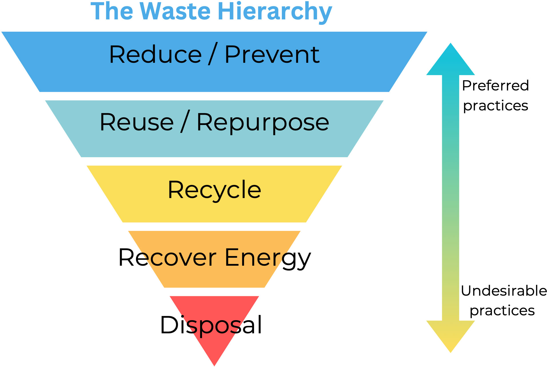
what are the four approaches to waste management and how do they work?
reduce- producers consider lifespan of use and amount of packaging, consumers consider what they are buying
re-use- refurbishing items, used goods put to another use
recover- recycling goods such as glass and paper, composting waste
dispose- waste is put into a hole
what is the waste hierarchy?
what is norway’s bottle recycling scheme?
97% of bottles are recycled
pay one krone extra, get it back when you recycle the bottle
bottles can be recycled 12 times
if companies get involved they pay less taxes
clear—> coloured—→ other plastic
why is waste management and issue in mumbai and how is it being managed?
10,000 tonnes of waste a day
part of the dump caught fire and it was visible from space
15,000 factories in dharavi for waste management, employs 200,000 people
30,000 people are employed in collection of rubbish
waste management in amsterdam
government building run on sustainable energy
biogas from sludge is converted into electricity
recycle 99% of waste
waste management in singapore
what is a brownfield site?
a term used in urban planning to describe land previously used for industrial purposes or some commercial uses