Nebraska FFA Agronomy CDE- Soil
1/29
There's no tags or description
Looks like no tags are added yet.
Name | Mastery | Learn | Test | Matching | Spaced | Call with Kai |
|---|
No analytics yet
Send a link to your students to track their progress
30 Terms
Glacial Till
Nebraska soils have formed in a variety of parent materials, namely alluvium, eolian sand, glacial till, and loess. Based on the surface textures in the fields depicted in the map below, what parent material is likely NOT present in this area?
A. Eolian Sand
B. Alluvium
C. All of the Above
D. Loess
E. Glacial Till
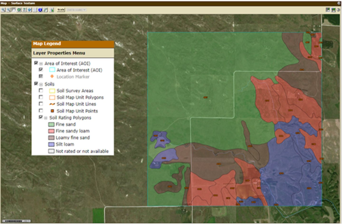
High
Hydraulic conductivity, the rate at which soil transits water, is largely controlled by the soil texture. Based on the map above, what is the relative rate of hydraulic conductivity for the green shaded areas?
A. Moderate
B. High
C. Low
D. Hydraulic conductivity would be the same in all soils
Depression
The map below shows the distribution of organic matter (%) in soil surface layers in an area in central Nebraska. Note the area of relatively high organic matter (%) bounded by areas of relatively low organic matter, and consider the factors that allow for high rates of organic matter accumulation. What is the likely landscape position of the high organic matter (%) area (black arrow)?
A. Cannot be determined
B. Backslope
C. Summit of a hillslope
D. Depression
E. Stream terrace
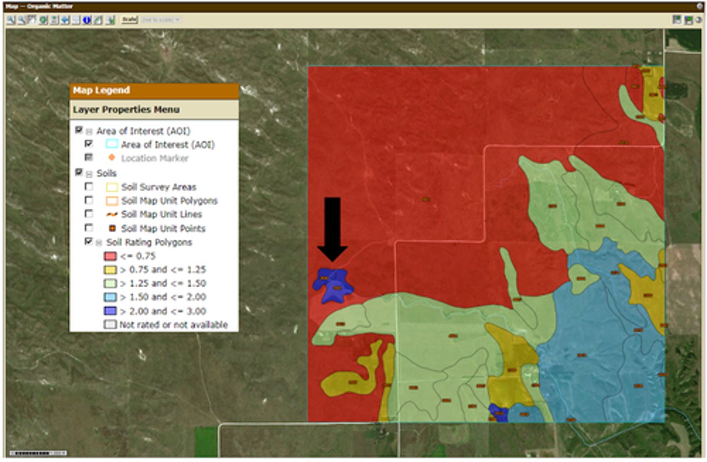
All the above
For this area, low amounts of organic matter are associated with fine and surface texture. Why would this be the case?
A. Relatively little biomass in the fine sand soils
B. Relatively low available water capacity in the fine sand soils
C. All the above
D. None of these
E. Relatively fast organic matter turnover in the fine sand soils
Very Low (<6)
Cation exchange capacity (CEC) is the ability of a soil to supply nutrients to plants, from cations stored on negatively charged CEC sites like clay and organic matter. Overall, what CEC class would this area fall into?
A. Low (6-12)
B. Moderate (12-25)
C. Very High (>40)
D. Very Low (<6)
E. High (25-40)
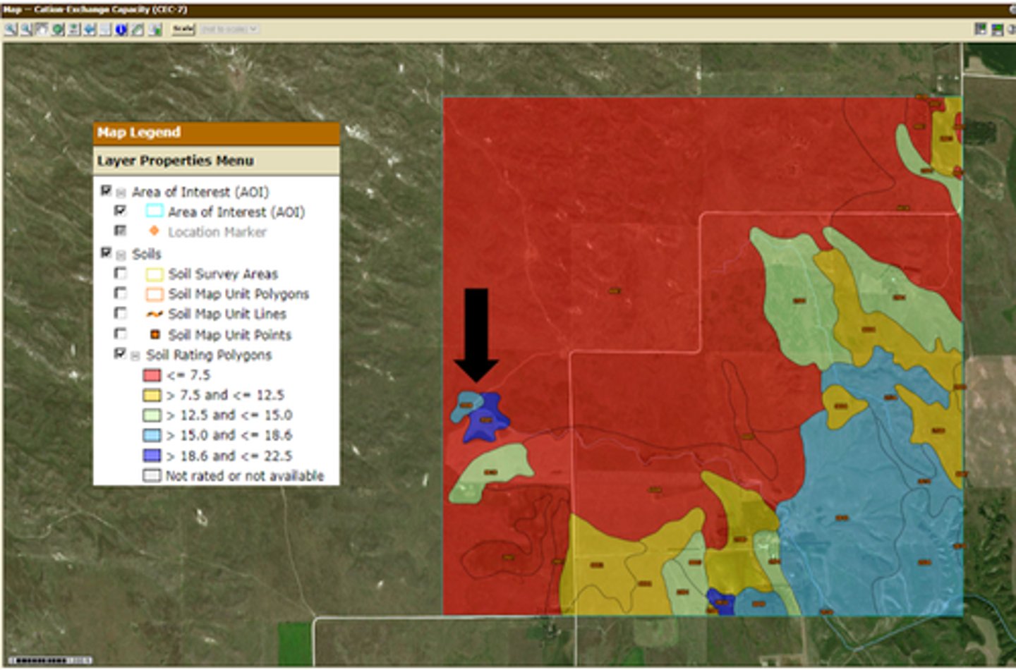
Relatively higher amounts of organic matter in this area AND relatively higher amounts of clay in this area
Why does the area note by the black arrow have a significantly higher cation exchange capacity than the soils surrounding it?
A. Relatively lower amounts of clay in this area
B. Relatively higher amounts of organic matter in this area
C. Relatively higher amounts of organic matter in this area AND relatively higher amounts of clay in this area
D. Relatively lower amounts of organic matter in this area
E. Relatively higher amounts of clay in this area
Bowed or cracked walls
The map below shows the suitability of the soil to support dwellings with basements in an area in central Nebraska. There is a small area of soils in the western portion of this area that very limited in their suitability to support dwellings with basements due to ponding and a shallow depth to the saturated zone. If a dwelling with a basement were constructed in this area without this knowledge, what is/are a potential impact on the structure of the basement?
A. Bowed and cracked walls, collapsed foundation, AND water seepage
B. Bowed and cracked walls AND collapsed foundation
C. Water seepage
D. Bowed or cracked walls
E. Collapsed foundation
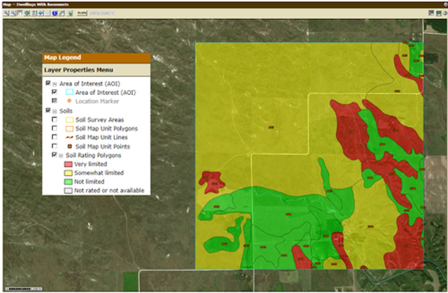
The ease and amount of excavation
The ratings for dwellings are based on soil properties that affect the capacity of the soil to support a load without movement and on the properties that affect excavation and construction costs. The "somewhat limited" soils in this area are limited due to the slope, which is a property that would most likely impact?
A. The compressibility
B. The soil texture
C. The ease and amount of excavation
D. None of these
E. The load-supporting capacity
Class VI
The map below shows the land capability classification of soils in an area in central Nebraska. Based on the map above, what is the dominant land capability class for this area?
A. Class II
B. Cannot be determined
C. Class IV
D. Class VI
E. Class III
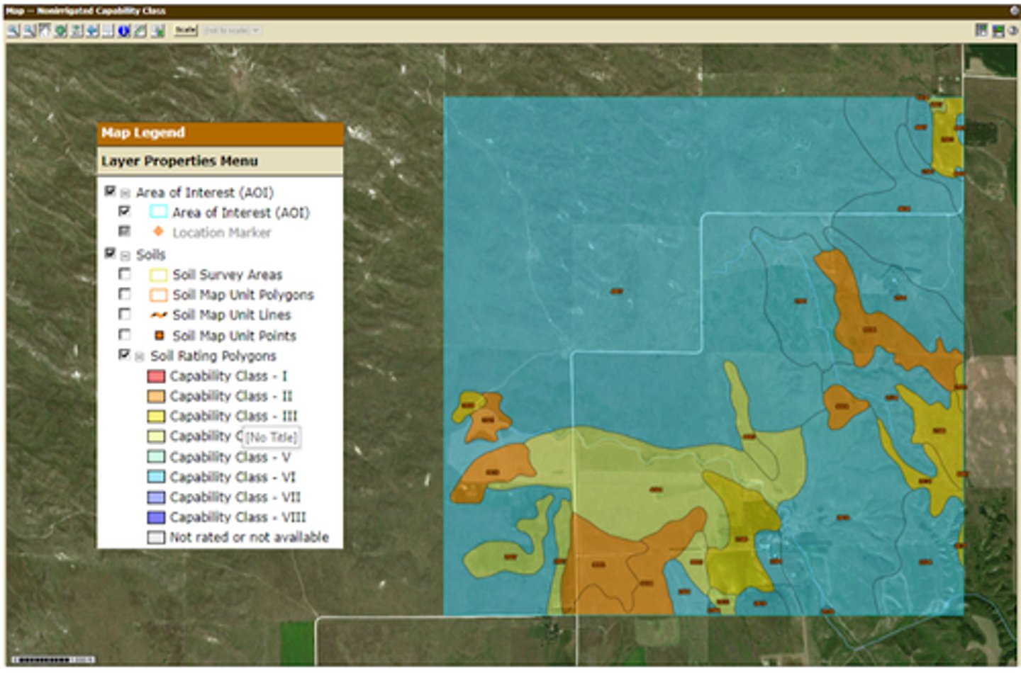
Low available water capacity AND low cation exchange capacity
Land capability classification shows, in a general way, the suitability of soils for most kinds of field crops. The northwest corner of the map includes areas along the southeastern edge of the Nebraska Sand Hills. What soil property, or properties, make that area of the map generally unsuitable for cultivation, and also restricts the use mainly to pasture, rangeland, and wildlife habitat?
A. Low available water capacity, low cation exchange capacity, AND high amounts of organic matter
B. Low cation exchange capacity
C. High amounts of organic matter
D. Low available water capacity AND low cation exchange capacity
E. Low available water capacity
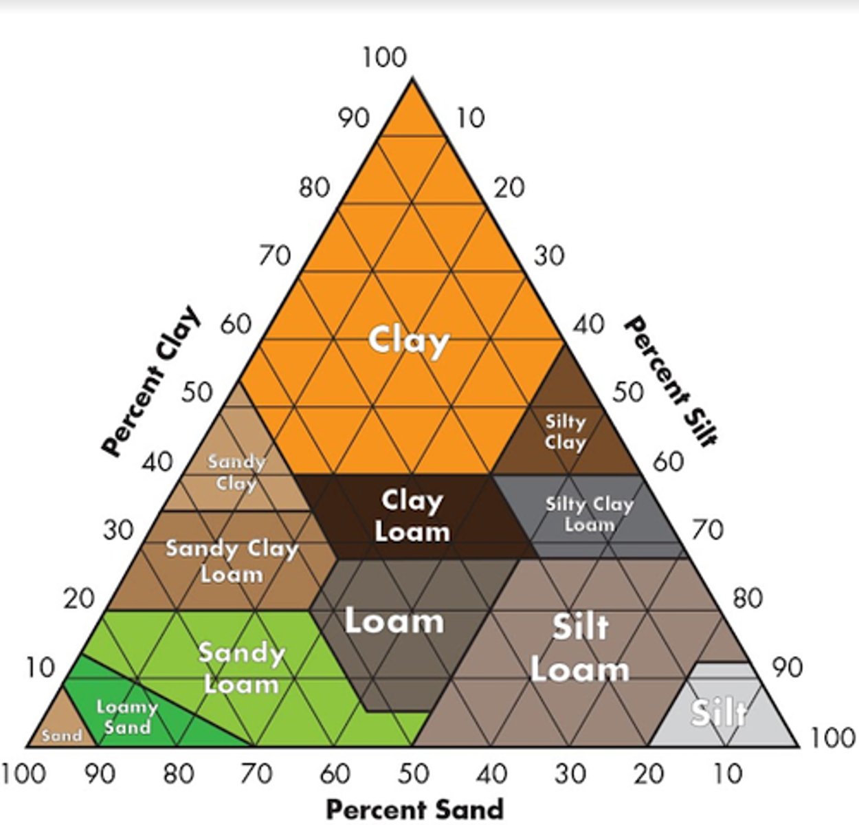
Clay
Which soil particle has the MOST amount of surface area?
A. Clay
B. Loam
C. Sand
D. Silt
Organic matter (humus)
Which component of soil makes up the least volume (by percentage) in a typical soil?
A. Organic matter (humus)
B. Soil minerals
C. Air
D. Water
Salinity
An accumulation of soluble salts at the soil surface would be indicative of what soil problem?
A. Sodic
B. Erosion
C. Organic matter accumulation
D. Salinity
Sand
Which of the following soil particles are the largest in terms of size (diameter)?
A. Silt
B. Sand
C. Loam
D. Clay
Negatively charged ions (CL-, H2PO4-)
Cation Exchange Capacity (CEC) is a measurement of how many ___________ charged ions can be retained in the soil profile.
A. uncharged ions (H2O)
B. Negatively charged ions (CL-, H2PO4-)
C. Positively charged ions (K+, Mg2+)
Eolian/aeolian (wind)
For a majority of Nebraska soils, soil material was predominantly transported by:
A. Colluvium (gravity)
B. Glacier till (glaciers)
C. Eolian/aeolian (wind)
D. Alluvium (streams)
E. Lacustrine (lake)
Soil Leaching
The movement of soil materials by water downward through the soil profile is best described as:
A. Soil Weathering
B. Soil Decomposition
C. Soil Aging
D. Soil Leaching
Silty Clay Loam
A soil which is comprised of 35% clay, 52% silt, and 13% sand would be described as which soil texture class?
A. Silt Loam
B. Clay Loam
C. Silty Clay
D. Silty Clay Loam
Silty Loam
Which of the following soils would have the highest plant-available moisture holding capacity?
A. Clay Loam
B. Sandy Loam
C. Silty Loam
D. All three loam soils have similar plant available water holding capacities
Sulfer (S)
Which of the following plant nutrients are primarily available in soil in an anion form?
A. Iron (Fe)
B. Zinc (Zn)
C. Potassium (K)
D. Sulfer (S)
E. Sodium (Na)
Decreased water holding capacity
Soils with higher levels of organic matter generally will have __________ compared to soils with lower organic matter.
A. Smaller soil pore space
B. Decreased water holding capacity
C. Higher bulk density
D. Increased cation exchange capacity
Decrease the pH of the soil profiles in the region
Climatic shifts leading to increased precipitation in a region would, with enough time:
A. Increase the pH of the soil profiles in the region
B. Decrease the pH of the soil profiles in the region
C. Have no effect on the pH of the soil profiles in the region
Rill erosion
What type of soil erosion is characterized by a series of small channels on a slope, carved by running water; usually traversable/repaired by farm equipment?
A. Sheet erosion
B. Saltation erosion
C. Gully erosion
D. Rill erosion
E. Splash erosion
22.0%
A soil that has an elevation change of 22 feet over a horizontal distance of 100 feet would have what percent slope?
A. 22.0%
B. 0.022%
C. 2.20%
D. 220.0%
E. 0.22%
Sand
Course-textured soils are typically dominated by which soil particle?
A. Silt
B. Sand
C. Clay
Iron (Fe) availability
The availability of plant essential nutrients in soils is strongly influenced by soil pH. Which of the following is a management concern associated with high pH soil?
A. Nitrogen (N) availability
B. Phosphorous (P) availability
C. Iron (Fe) availability
D. Calcium (Ca) availability
E. Potassium (K) availability
Living organisms
Which soil-formation factor is required to develop soil horizons?
A. Climate
B. Living organisms
C. Time
D. Parent material
E. Landscape position
Lower
Fields which are compacted or have very clayey soils will likely have _________ permeability compared to a non-compacted, low clay soil.
A. Similar
B. Compaction and/or clay concentration do not influence permeability
C. Higher
D. Lower
A horizon
As illustrated in the soil profile above/below, which soil horizon does most root activity occur?
A. R horizon
B. C horizon
C. A horizon
D. O horizon
E. B horizon
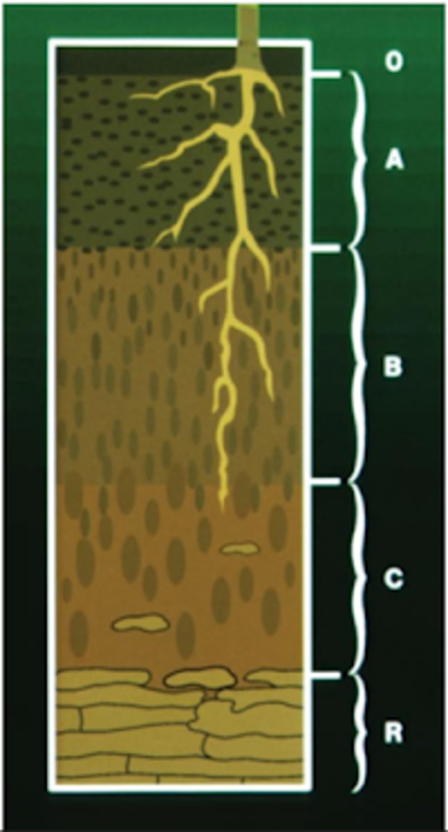
C horizon
Which soil horizon is comprised of partially disintegrated parent material, less weathered sediments, and less clay than the overlying horizons?
A. R horizon
B. E horizon
C. A horizon
D. C horizon
E. B horizon