Case study: Mappleton, the Holderness Coast
1/26
Earn XP
Description and Tags
Name | Mastery | Learn | Test | Matching | Spaced | Call with Kai |
|---|
No analytics yet
Send a link to your students to track their progress
27 Terms
Where is Mappleton located?
the Holderness coast
East Yorkshire
~3km south of Hornsea
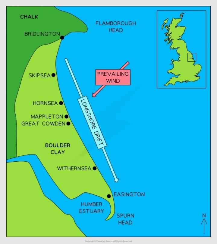
Which sediment cell is the Holderness coast located in?
sediment cell 2
What 3 main factors affect the Holderness coastal system?
geology
prevailing winds (wave energy)
management
What are some of the distinctive coastal landscapes around Holderness?
steep chalk cliffs
slumping cliffs
wave-cut platforms
beaches
headland (Flamborough Head)
sand dunes
spit (Spurn Head)
What is the erosion rate at Mappleton?
~2m/year
What is the population of Mappleton?
~340 people
~50 properties
What is the main road serving Mappleton?
the B1242, which connects settlements along the Holderness coast
What is the geology of Mappleton?
boulder clay (glacial till)
deposited during the last ice age (~18,000 years ago)
soft
erodes quickly
Why is Mappleton at risk from erosion?
made of soft boulder clay
exposed to destructive waves on the Holderness coast, leading to rapid coastal retreat
Why was coastal management implemented at Mappleton?
to protect the B1242 road and the village, as it was cheaper than relocating the road and settlements
What are the main coastal defences used at Mappleton?
rock groynes
rock armour (revetment)
cliff re-profilling
How much did the coastal defences at Mappleton cost?
approx. £2 million in 1991
What materials were used in the coastal defences at Mappleton?
granite imported from Norway was used for rock armour and groynes
What is the purpose/function of groynes?
trap sediment moved by longshore drift
build up a wider beach
How do groynes affect longshore drift?
interrupt longshore drift
prevent sediment from moving along the coast
What is the purpose/function of rock armour?
absorb wave energy
protect the base of the cliffs from erosion
Why is vegetation used on the cliffs at Mappleton?
stabilise slopes
help reduce mass movement (e.g., slumping, mudflows)
What is a positive impact of the coastal defences at Mappleton?
reduced erosion between groynes
created a wider beach
How have the coastal defences benefited infrastructure at Mappleton?
protected the B1242 road from coastal erosion
How have coastal defences affected tourism at Mappleton?
the wider, sandy beach and facilities (car park and toilets) have attracted more tourists
What is a negative impact of the coastal defences on downdrift areas?
reduced sediment supply has increased erosion further south along the coast
Why does erosion increase downdrift of Mappleton?
groynes trap sediment, so less material is transported further along by longshore drift
Which location is negatively affected downdrift of Mappleton? What are the impacts there?
Cowden
erosion rates increased significantly after the coastal defences were built (increased from ~1m/year to ~3m/year)
loss of land and property, including farms and homes
What conflict is caused by Mappleton's coastal defences?
tension between local authorities protecting Mappleton and landowners further along the coast who experience increased erosion
What is the overall evaluation of Mappleton's coastal management?
effective locally in protecting property and infrastructure
causes negative downstream impacts
What type of waves affect the Holderness coast?
destructive waves
erode cliffs
remove sediment faster than it is deposited
Why is beach formation at Mappleton important?
a wider beach acts as a natural barrier, absorbing wave energy and reducing erosion of the cliffs