ocean basins- chapter 15
1/53
There's no tags or description
Looks like no tags are added yet.
Name | Mastery | Learn | Test | Matching | Spaced | Call with Kai |
|---|
No analytics yet
Send a link to your students to track their progress
54 Terms
Where did water come from?
Native volatiles from the molten early Earth and Cometary water
Why do volcanoes still spew water vapor?
Volatiles recycled with tectonic activity
what are Native volatiles from the molten early Earth?
Gases from initial coalescence
what is cometary water?
The moon-forming impact would have caused net loss of volatiles
what are three crustal differences?
•Oceanic crust is denser than continental crust
•Rides lower – isostatically
•Thinner – 4 to 7 kilometers (km) versus 20 to 40 for continental crust
What is true about the ocean basins size?
•Ocean basins cover 71% of Earth
•2 to 11 km in depth (approximately 5 km average)
•1.4 billion km3 water
•No basins, water would be 2 km deep everywhere
rock dredge
open mouth steel net
coring
a pipe is used to collect a mud core
sea-floor drilling
like as used for oil drilling
submersibles
both manned and robotic
echo sounding
used to map seafloor topography (SONAR)
seismic profiler
like sonar, but higher-energy waves penetrate sea-floor and reflect data back
magnetometer
towed behind ships to record magnetic fields of rock
microwave radar
used to map sea-surface, surface mimics sea-floor topography
mid-ocean ridges:
•After World War One – early echo-sounding technology showed topography
•After World War Two – more detailed maps made for naval use
mid-ocean ridge system
continuous mountain chain connected across the globe, about 80,000km long
rift valley
•1 to 2 km wide split along the ridge’s center where new crust forms
•Normal faults and earthquakes in valley
transform faults
hundreds of fractures crossing perpendicular to the ridge
black-smokers
sulfur-laden jets of hot water occurring near ridges
Chemosynthesis
bacteria produce hydrogen sulfide in the black-smokers

what is happening in this picture?
A cross-sectional view of the central rift valley in the Mid-Oceanic Ridge. As the plates separate, blocks of rock drop down along the fractures to form the rift valley, bounded by normal faults. Movements across these faults cause earthquakes.

what is happening in this picture?
The seafloor sinks as it grows older. At the Mid-Oceanic Ridge, new lithosphere is buoyant because it is hot and of low density. As it moves away from the ridge, the lithosphere cools, thickens, and becomes denser, causing it to sink. On average, the seafloor lies at a depth of about 4 kilometers, relative to 2 to 3 kilometers at the Mid-Ocean Ridge.
fast spreading of the seafloor causes a _____ seafloor
higher
higher seafloor means _____ volume for water
less
how does the seafloor spread?
•Continent and basin ratios affect sea-level
•Tectonics can cause continents to move, shift, come together, and become relatively higher or lower

what is happening in this picture?
(A) Slow seafloor spreading creates a narrow, low-volume Mid-Oceanic Ridge that displaces less seawater and lowers sea level.
(B) Rapid seafloor spreading creates a wide, high-volume ridge that displaces more seawater and raises sea level.
trench
narrow, often deep, depression along a subduction zone
island arc
form above the subducting plate boundary
accreted terrane
when a plate with an island arc subducts and causes the arc to become part of the continental crust
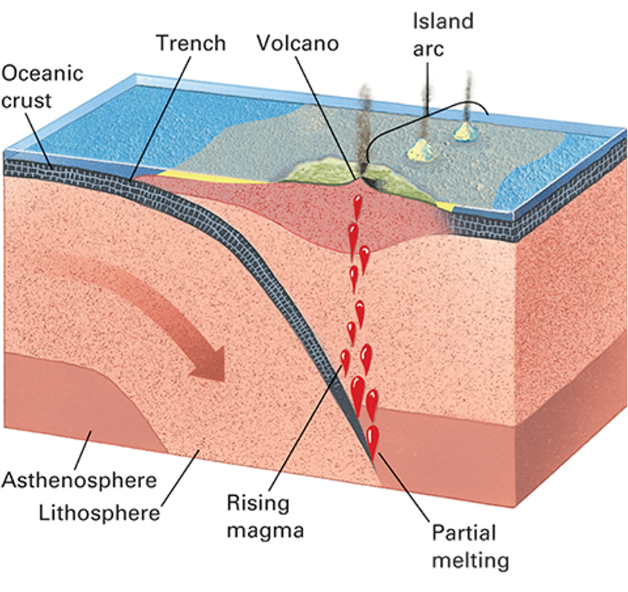
what is happening in this picture?
An oceanic trench forms at a convergent boundary between two oceanic plates. One of the plates sinks and heats, generating magma that rises to form a chain of volcanic islands called an island arc.
seamounts
submarine mountain that rises 1km above sea floor
oceanic island
a seamount that rises above the ocean surface
guyot
a worn down, sunken, oceanic island
atoll
circular coral reef surrounding a central lagoon
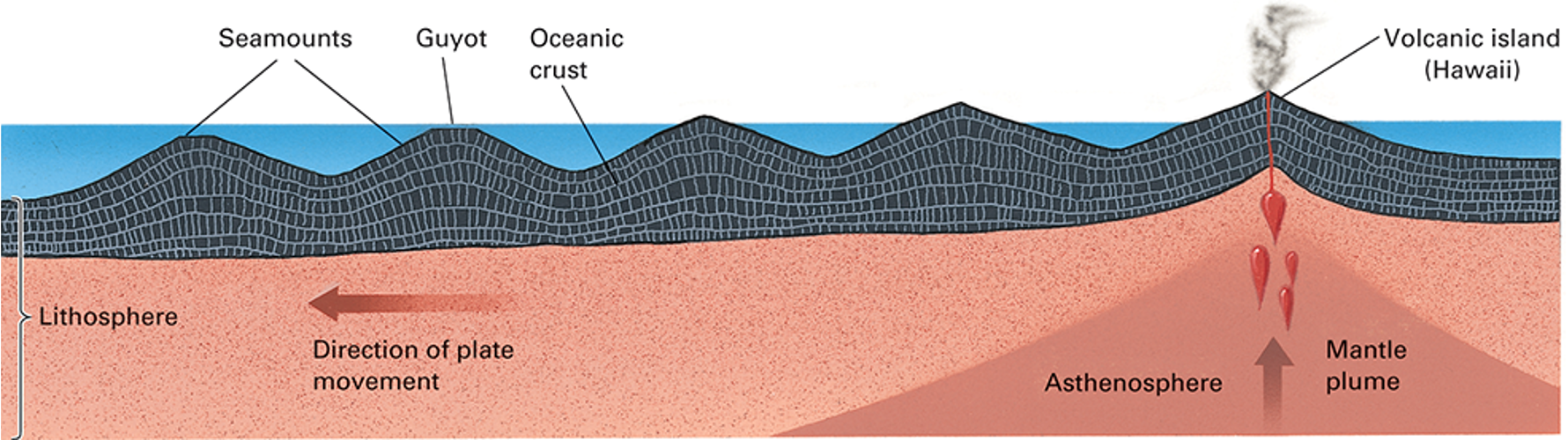
what is happening in this photo?
The Hawaiian Islands and Emperor Seamounts sink as they move away from the mantle plume currently located under the volcanically active Island of Hawaii.
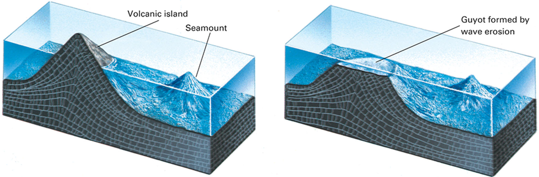
what is happening in this photo?
(A) A volcanic island rises above sea level.
(B) Wave energy erodes a flat top on a sinking island to form a guyot.
terrigenous sediment
sand, salt, clay erodded and transported from continents
pelagic sediments
mix of fine clays and biogenic debris
abyssal plain
flat expanses of pelagic sediments
Early thought was that old oceans would have thick sediments everywhere, but what was discovered later?
•Discovered in 1947 that mud was thinner closer to ridges
pillow basalt
•rounded basalt structure caused by magma oozing out into the cool ocean
•1 to 2km thick
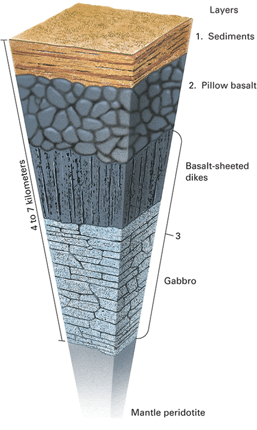
what does this picture show?
The three layers of oceanic crust. The uppermost layer consists of sediment. The middle layer consists of pillow basalt. The deepest layer is made of vertical dikes of basalt that merge downward into gabbro. Below this lowermost layer of oceanic crust is the upper mantle.
passive continental
continental and oceanic crust joined
continental shelf
shallow, gently sloping surface
sediment laden
isostatically depressed
carbonate platforms
limestone beds, occur in warm areas with little sediment
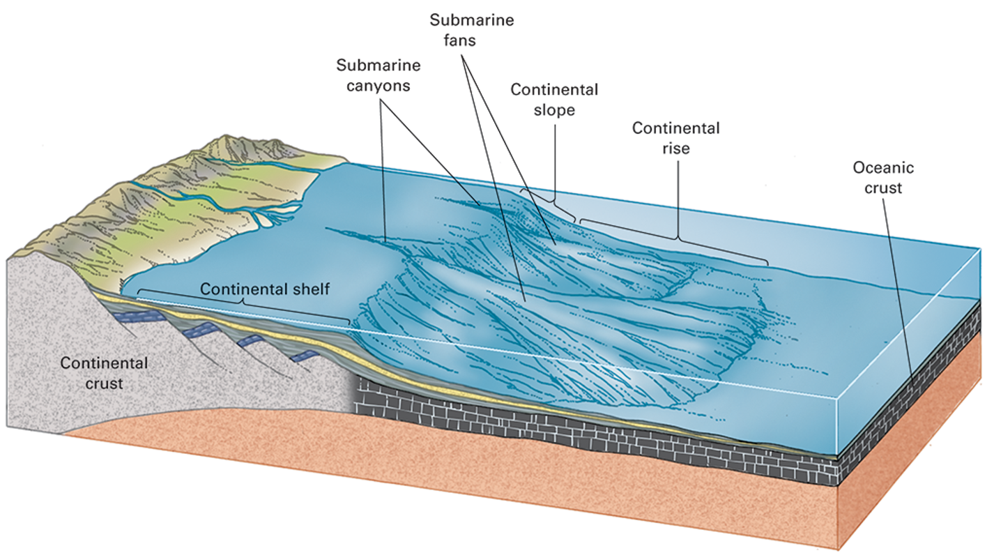
what is happening in this picture?
A passive continental margin consists of a broad continental shelf, a slope, and a rise formed by accumulation of sediment eroded from the continent.
continental slope
steep edge of the shelf where oceanic and continental crust meet
continental rise
slope shallows out and meets the deep ocean floor
submarine canyon
deep valley eroded into the continental shelf
abyssal fan
sediment fan often found at end of submarine canyon
Turbidity currents
•form when loose, wet sediments tumble downslope
•A rapid and extensive submarine landslide
active continental margins
form at subduction zones
•Once plate (oceanic) is actively descending beneath the other (continental)
•Trench associated with descending slab
4 degrees to 5 degrees near top, steepens to 15 degrees or more at depth

what is happening in this picture?
Along most active continental margins, an oceanic plate sinks beneath a continent, forming an oceanic trench. The continental shelf is narrow, the slope is steep, and the continental rise is small to nonexistent.