unit 6 Urban test
1/45
There's no tags or description
Looks like no tags are added yet.
Name | Mastery | Learn | Test | Matching | Spaced | Call with Kai |
|---|
No analytics yet
Send a link to your students to track their progress
46 Terms
Urbanization: city
Illegally find urban settlement that has a specific boundary and a local government
Urbanization: Urban area
A densely populated region that includes the city and the surrounding suburbs regarding of political boundaries.
Urbanization: Mega city
A city with 10+ million people
Urbanization: Meta city
A city with 20+ million people
Urbanization: World global city
A city that is highly connected to hubs of finance, culture, and politics. (NYC, LONDON, TOKYO)
Urbanization: Urban hierarchy
Ranking of cities based on their size, economic power, and influence
Urbanization: why are most mega cities in LDCs?
Because of rapid population growth and rural to urban migration, this can lead to overcrowding, pollution, and housing shortages.
Urbanization: Americas Urban hierarchy 1
New York City, Alpha/global city
Urbanization: America’s urban hierarchy 2
Los Angeles, major, economic, and cultural center
Urbanization: America’s urban hierarchy 3
Chicago, transportation and economic hub
Urbanization: urban areas
They developed along major, transportation routes and water, like rivers and coast, they expanded rapidly during the Industrial Revolution
Urbanization: 1st urban revolution
Why? agricultural surplus. when? first cities and Mesopotamia
Urbanization: 2nd urban revolution
Why? industrial revolution. when? 1700s to 1800s Great Britain, factories plus lots of jobs (cottage industries)
Urbanization: The 5 hearths of urbanization
Mesopotamia in the Middle East
Nile River Valley, Egypt
Indus Valley, Northwest India
Huang he, China
Miss America (Latin America)
Urbanization: rust belt
Old industrial areas in the Midwest/northeast US, it experienced decline in industries, but it is now re-industrializing and gentrifying. It was the first area to industrialized and de-industrialize.
Urbanization: Urbanization by regions of the world
The most urbanized by % is South America
China has the largest number of people in mega cities
Fastest growth would be Africa
Urbanization: Interdependence
A relationship where two or more places/countries develop on each other for goods, services, and resources
Urbanization: What are the most interdependent world cities?
North America and Europe due to the trade, finance and global businesses that they network together.
Urbanization: Urban morphology
The study of the physical form and layout of cities overtime, and how it changes
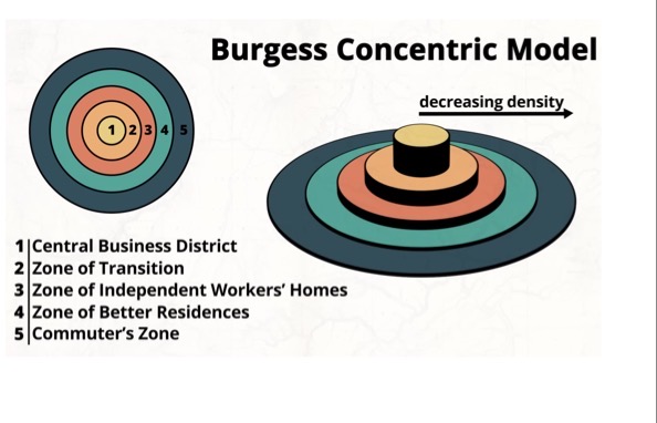
Structure of urban areas North American cities: Burgess concentric zone model
Has circular rings that sprout outward from the CBD. It goes out from working class industries middle class and commuters. The farther you get the less density there is of people.
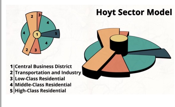
Structure of urban areas North American cities:Hoyt sector Model
Wedge shaped sectors CBD, less dominant low income resident’s, always near factories and transportation
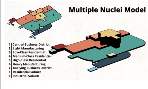
Structure of urban areas North American cities:(Harris and Ullman) Multi Nuclei model
Multiple centers (nodes) developed because the importance of CBD’s is decreasing, lots of business districts in high consumption areas in each node.
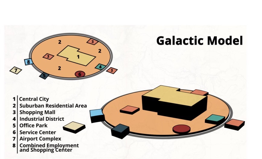
Structure of urban areas North American cities: Galactic Cities model (Harris and Ullman)
Cities are spread outward (urban sprawl). It creates multi cities and the growth of edge cities surrounding the CBD in a ring (suburbs), highly dependent on transportation and cars.
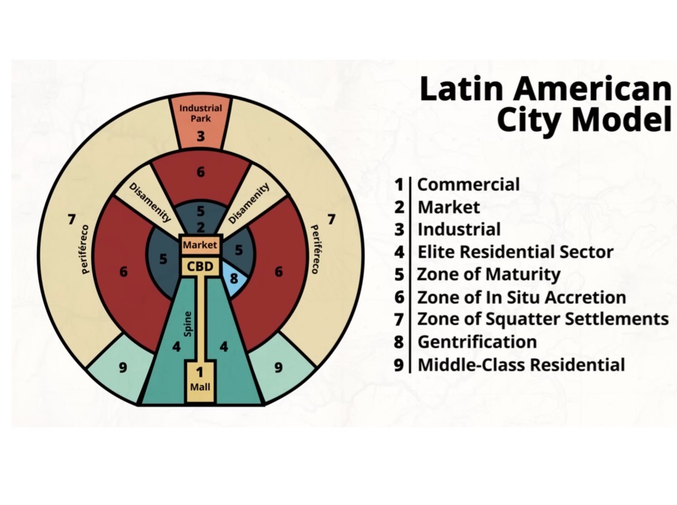
Structure of urban areas Cities in the periphery/semiperiphery: Latin America model
The CBD consists of a plaza and a religious building. The elite are in the center and the poor are on the outskirts lots of Favela’s (squatter settlements).
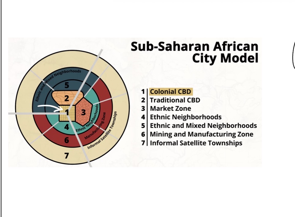
Structure of urban areas Cities in the periphery/semiperiphery: Sub Saharan Africa
CBD consists of a market and a traditional CBD (2 CBDs), influenced by colonization. Ethnic and mixed and industries surround the CBD while the squatter settlements circle around everything.
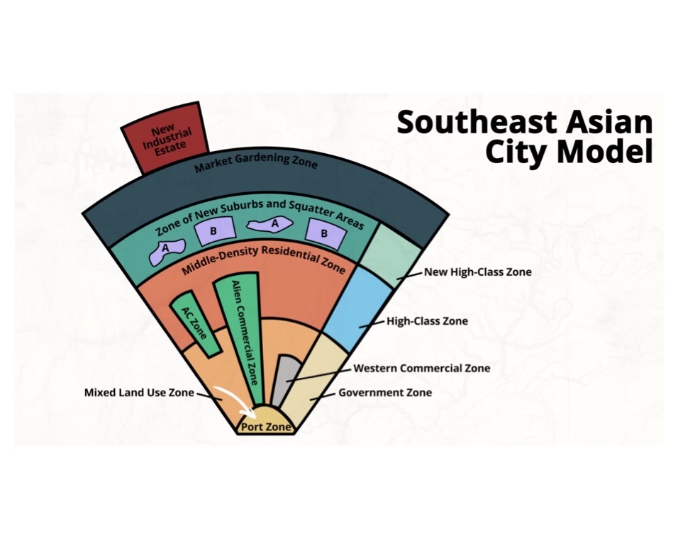
Structure of urban areas Cities in the periphery/semiperiphery: Southeast Asia
The CBD focuses on a port for exporting manufactured goods. It comes from colonial needs. Special economic zones sprout from the port towards all the sectors. New industries are at the edge. Poor and well off residence live clustered together. New housing and government buildings are on the side.
Structure of urban areas: rank size city
There is only one large city in the country. The second largest city is 1/2 population of the largeest city, the third largest city is 1/3 population of the largest city, the fourth largest city is 1/4 population of the largest city.
Structure of urban areas: Primate city
A city that is twice as large as the next, dominating the countries, economic, political, and cultural functions (Paris, Mexico City)
Structure of urban areas: suburbanization
When people move from city to the surrounding areas of a city (suburbs).
push= congestion, pollution, crime
Pull= more space better schools cheaper housing
Structure of urban areas: Footprint in urban areas
Decreased by skyscrapers, they grow up instead of out and it reduces land use, retail is on ground floors.
Structure of urban areas: Squatter settlements
People building housing illegally and informally the housing, often lacks water and electric electricity, it is usually found in LDCs.
Structure of urban areas: Urban ghettos
Section of a city where a minority lives due to economic or social pressure, the neighborhoods are often segregated as a result of segregation in the US.
Structure of urban areas: Filtering
Housing decline→ lower income residence move in.
Structure of urban areas: Redlining
A discriminatory practice where banks deny loans to certain (often minority) areas based on race or ethnicity.
Structure of urban areas: Blockbusting
Real estate agent scare white homeowners to sell their houses for cheap in fear of minorities that would move in, then real estate agent sell it to the minorities for a high price.
Structure of urban areas: Gentrification
Process where wealthy individuals begin to move into poor or working class community, the area improves
pros= investment and becomes safer
Cons= displacement of poor residents.
Structure of urban areas: Spaces of consumption
Areas designed for people to spend money on entertainment goods, and services
→ ex: entertainment district like New York Times Square and Navy, tourist, and shopping malls
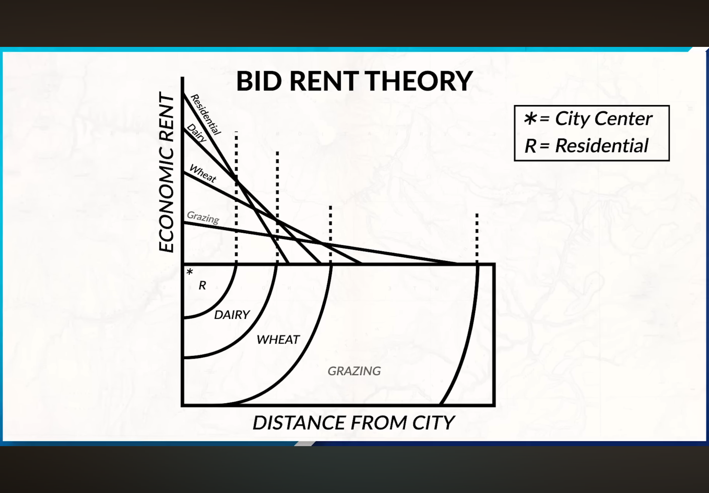
Services: bid rent theory
Explain how land value changes with distance from the CBD.
→ Closer to CBD equals higher land costs because of accessibility businesses that locate there and pay more while industries would locate farther away to save money.
Services: Threshold
Minimum number of people needed to support a service (Ex. Grocery store needs enough customers to open.)
Services: Range
Maximum distance people are willing to travel for a service (ex. Low order goods = low range and low threshold like gas and food, high order goods = high range in high threshold like luxury items.
Services: Where are retail locations in the CBD?
On the ground floor of buildings, along main streets with a high amount of foot traffic, and in clustered areas with maximum accessibility.
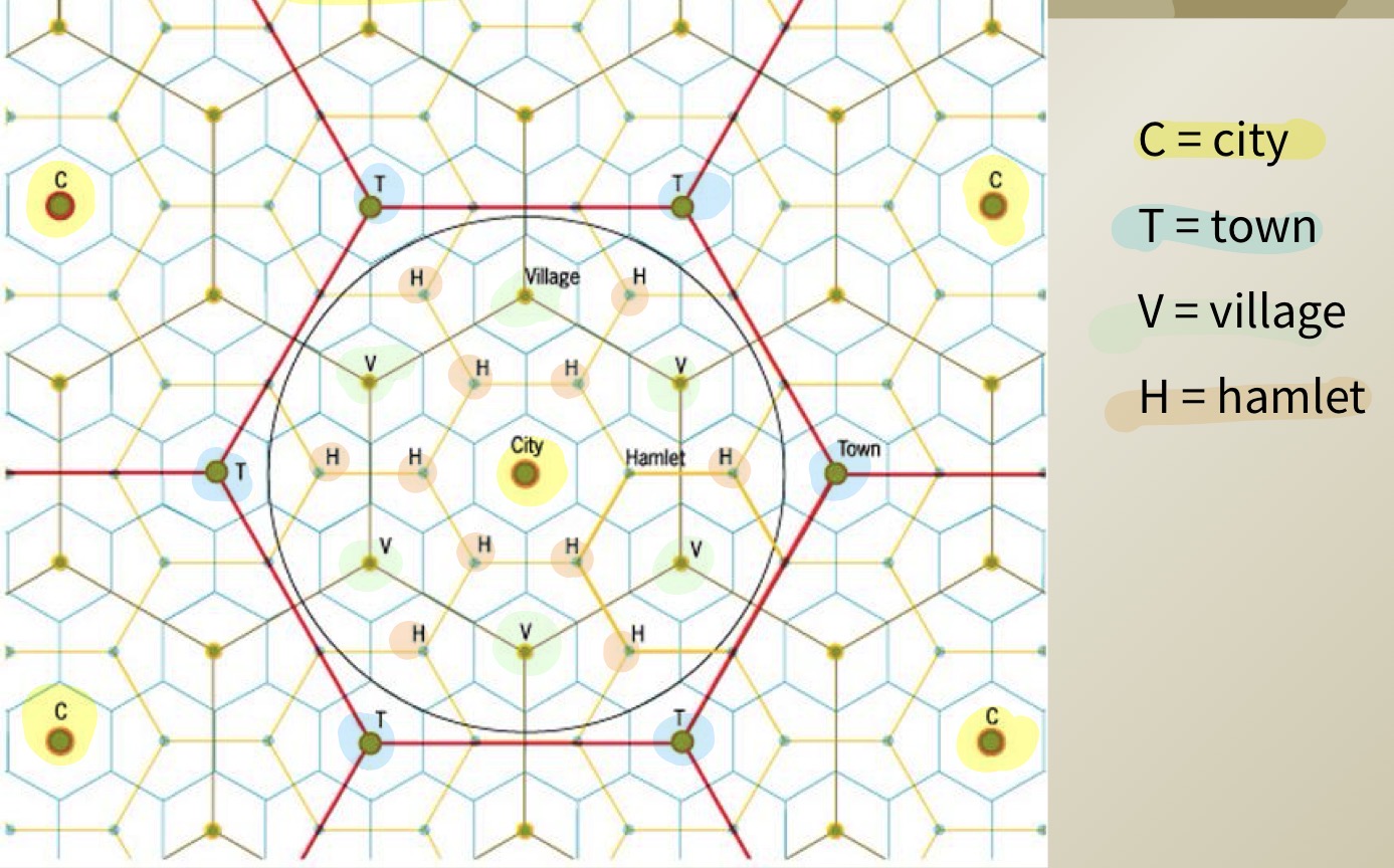
Services: Christallens Central Place theory
Why a hexagon? It has no gaps, unlike circles. It has efficient coverage of space and there is equal distance between centers.
→ each hexagon is a market area people go to nearby places for everyday goods farther for specialized goods
Services: Basic export industries
Bring money into a city, sell goods and services outside of the city (factories, tourism, and tech companies).
Services: Non-basic local industries
Serve people within the city (grocery stores, schools, hair salons)
Services: Gateway cities
Cities that act as an entry point to a region or country often located at ports, airports, and borders.
→ Connect international trade to inter (Ex. Los Angeles Pacific trade, & New York Atlantic trade.)
Services: Gravity model
Predicts interaction between two places based on population size and the distance between them. It is used for trade, migration and transportation planning.