L14 Mountain permafrost and climate
 Call Kai
 Learn
Learn Practice Test
 Spaced Repetition
 Match
Match Flashcards
 Knowt Play
1/27

There's no tags or description
Looks like no tags are added yet.
Name | Mastery | Learn | Test | Matching | Spaced | Call with Kai | Chat |
|---|
No analytics yet
Send a link to your students to track their progress
28 Terms
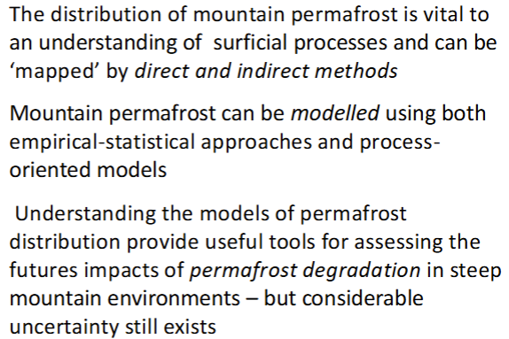
How important are montane environments for permafrost, and how is this changing?
One third of permafrost is located in mountainous terrain;
Huge glacial change and retreat is associated with decreases in the permafrost table → evidence of this in the European Alps;
Global heating has increased rockfall and GLOFs; and
Mountaious vegetation and fauna (esp with specific climatic ranges) will be threatened → affect soil stability, socio-economic activities, and resources for indigenous communities.
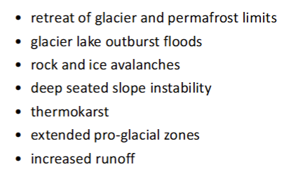
How does climate change pressure mountain permafrost, and what are some associated cryospheric hazards that may come with this?
Global warming → influences thermal stability of surface and subsurface ice. Triggers shifts in glacier (surface) and permafrost (subsurface) equilibrium limits.
Associated hazards in image.
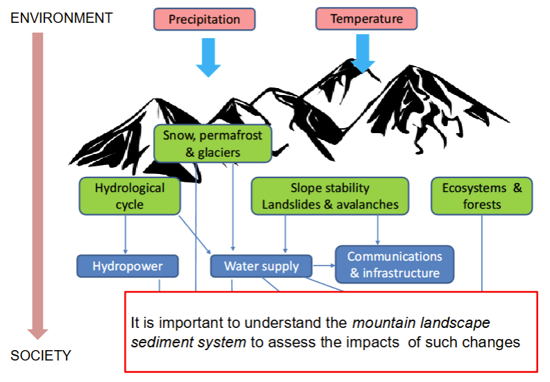
What is an example of a potential climate warming scenario in the mountain cryosphere, and how may this link to society?
More GLOF and glacier hazards;
Permafrost degradation and slope instability;
Decline in material strength of foundations of high mountain buildings; and
Damage to reservoir systems and infrastructure; increased sedimentation rates so reduced storage capacity.
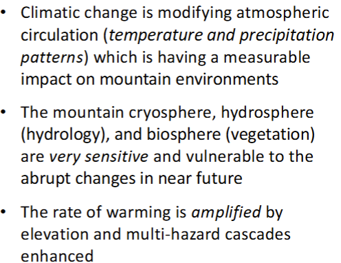
What is elevation dependent warming in mountains, and what mechanisms may affect this?
EDW → when the rate of warming is amplified with elevation;
This may be affected by albedo, cloud cover, water vapour, blackbody emission (radiation balance), and aerosols.
Why is climate change significant in mountain landscapes?
Abundant sediment supply and high erosion potential;
High rates of sediment production and transfer;
Steep slopes - instability and active channel sediment transport;
Variability in the spatial and temporal rates of sediment transfer;
Mountain landscapes are sensitive to disturbance from both climate change and anthropogenic impacts;
High incidence of geomorphic hazards which places infrastructure at risk; and
Mountain landscapes are part of a larger drainage system.
What are three summary points of part A?
How is permafrost defined?
Ground of any type colder than the freezing temperature of water for several years (usually > 2 years in equilibrium with climate). Muller (1945) introduced permafrost to mean perennially frozen ground.
How does mean ground temperature mantain at low temperature for long periods of time?
Frozen ground limited to a thin surface layer depending on heat flow at the surface;
Surface energy exchanges are an order of magnitude greater than geothermal heat flux;
Ground heat flux driven by radiative energy;
Annual incomings and outgoings remain consistent; and
Mean ground temperature remains constant.
What are trumpet curves used to show?
Surface temperature extremes are damped out with soil depth;
Annual ground temperature variation decreases steadily from the ground sufrace to depth of approx. 6 - 15m; and
This is shown in a trumpet curve.
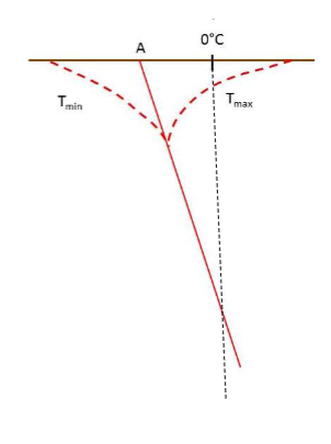
What is an enevelope curve?
Defined by fluctuations in ground temperature with depth (Tmax - Tmin); and
Below this depth the temp increases steadily due to the influence of the internal heat of the Earth (geothermal gradient).
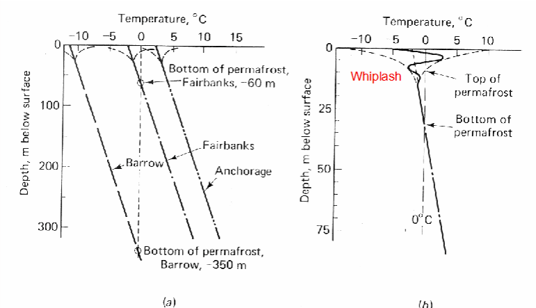
What is he mean annual ground temperature of permafrost generally, and what type of curve can demonstrate this?
The mean annual ground temp at the surface is negative and a frozen layer exists; and
Demonstrated by a whiplash effect in temperature as depth decreases.
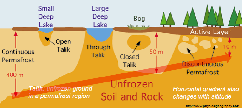
What are the two main thermal ground regimes in cold mountainous regions?
Seasonal frost; and
Permafrost.
What is seasonal frost?
The active layer in which temp fluctuates below/above 0 degrees during the year.
What type of definition of soil is usually adopted within the study of permafrost?
Engineering definition:
Physical mineral fractions; and
Soil water and air (e.g., porosity → changes); and
Composition varies between the amount and phase of water and mineralology; and
Heat is mainly transferred by conduction.
What are three key properties of soil under an engineering definition?
Thermal conductivity;
Volumetric heat capacity; and
Thermal diffusivity.
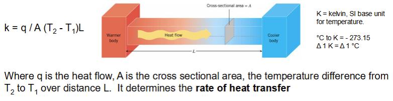
What is thermal conductivity?
The amount of heat that will flow through a unit area in a given time under a constant gradient. If the temperature (how hot something is) is changing the soil must be losing or gaining hear (thermal energy contained in an object).
What are volumetric and mass specific heat capacities?
Mass specific heat capacity ( c) is the amount of heat required to raise 1kg of soil by 1 K (J kg -1 K-1).
Volumetric heat capacity ( c ) is the mass heat capacity of the substance multiplied by the density of the substance (J m-3 K-1).
What the temperature increase in an object caused by heat energy transfer depend on?
Mass of the object;
Material the object is made of; and
Amount of heat energy transferred.
What is the thermal behaviour of a soil governed by, and how can this be expressed through an equation?
Governed by thermal conductivity and heat capacity. The ratio of these two properties of (k/C) is the thermal diffusivity (alpha).

How is the state of water determined?
By pressure and freezing;
Freezing → one pressure atmosphere and in sufficient quantity water will freeze at 0 degrees c (pure water). Water in soils and rocks may freeze over a temperature range. Effect is the depression of the freezing point.
Soil water freezing point depression is only of the order of 0.1 degree celsius.
Suction results from molecular forces acting at the interface between phases when ice begins to form, and adsorption acts on the surfaces of mineral particles. These effects become greater as temperature falls and the amount of residual water is reduced.
What are some uses of these physical (phase changing) characteristics of water?
Calculations of the depth of frost and thaw;
Engineering problems involving artificial ground freezing;
Soil thermal behaviour for microclimatological research and agriculture;
Evaluation of the geothermal heat flux;
Burial of power cables and construction; and
Stability of slopes and rockwalls.
What are four summary points of part B?
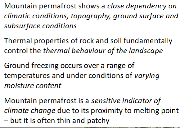
Why is the knowledge of mountain permafrost and the threats to it important?
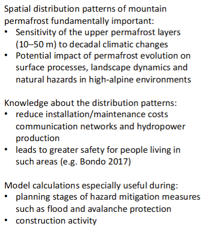
How can permafrost be mapped and detected?
Detection (direct):
Drilling (common but costly);
Geophysical surveys (electrical resistivity, GPR); and
Seismic surveys.
Detection (indirect):
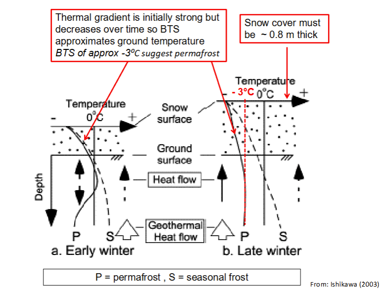
Correlating between climatic variables and ground freezing - Bottom temperature of winter snow cover (BTS). Inexact due to variability in soil texture, moisture content, aspect, elevation, surface cover, etc; and
Modelling approaches.
What is the bottom temperature of winter snow cover (BTS)?
Thick insulating snow cover > 0.8m protects the ground surface from short-term periodical variation in air temperature;
BTS in late winter reflects subsurface thermal conditions;
BTS mapping, which is undertaken by thermal probes manually pushed through the snow cover to the ground surface, provides rapid survey of permafrost distribution; and
Frequently applied in order to predict the meso-scale distribution of mountain permafrost.
What are the two main types of permafrost distribution models?
Regionally calibrated empirical-statistical models;
Physically based process-oriented models → analytical empirical or numerical heat flow.
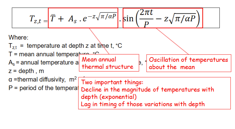
What is the geothermal heat flow model (based on Riseborough et al. 2008)?
Equation describes ground temperatures at any time and depth below the ground surface that experience sinosoidal variations in temperature.
What are three summary points for part C?