Geog 201 FINAL
1/31
There's no tags or description
Looks like no tags are added yet.
Name | Mastery | Learn | Test | Matching | Spaced | Call with Kai |
|---|
No analytics yet
Send a link to your students to track their progress
32 Terms
What is the Koppen Classification system? What are climate regions?
Koppen’s classification system categorizes the world’s climate based on distribution of natural vegetation, precip., and temp.
5 Climate regions: first letters
A → hot, humid
B → dry
C → warm temperate
D → cool temperate
E → cold
What are the subtypes for the climate regions (w/ a D & C focus)?
Second letters
w → dry winter
f → uniform regime
s → dry summer
Third letters:
a → hot summer
b → warm summer
c → short summer
d → severe winter (only applies to D)
Regional climates and their subtypes?
A climate (does not get a third letter)
f → wet year round, no dry season
w/m → some dry season bc it’s far enough from the ITCZ band that as it shifts, there will be some dry seasons
B climate: 50º N/S, normally found between 15-30º (dry bc they don’t get enough precip)
E climate:
f → every month below 0º C
Weather extremes, why did they occur? (temp)
Death Valley (134ºF) → dominated by STHP (sinking air), below sea level, dry area
Ethiopia (94ºF) → STHP dominated, closer to equator
Antarctica (-129ºF) → high latitude, snow over, ice sheet having elevation
Siberia (-90ºF) → continental air, high latitude, snow cover
Weather extremes, why did they occur? (precip)
Hawaii (486 inch) → trade winds, N.E. side windward of mountain, tropical ocean
India (1,042 inch) → 2 summer monsoon seasons in summer stretch, orographic uplift
Southern Chile (325 days of precip) → Westerlies blowing up windward side, orographic uplift
Northern Chile (3/100th of precip in a yr) → well developed cold current (stable air), leeward side of mount.
Snow
Washington State (1,140 inches in a yr) → wetter winter, orographic lifting, high elevation
New York (70 inch in a day) → lake effect snow
Weather extremes, why did they occur? (wind)
Antarctica (monthly & yearly) → 65 mph & 44 mph bc of pressure and temp gradient
What are small scale climates?
Macroclimates → large scale features, 100+ miles
Mesoclimates → medium scale features, 3-100 miles
Microclimates → small scale features, <1 inch - 1 mile
Important mesoclimates
→ Lake effect snow (areas downward of major lakes receive heavy snow, occurs late fall/early winter w/ unstable conditions are prevalent)
→urban heat islands (a city is warmer than surrounding rural areas, esp during calm clear nights)
4 Major factors to urban heat islands
Urban surface material
artificial heat production
urban atmospheric pollution
urban 3D geometry
what are glacials and interglacials?
Glacials are when 33% of the Earth is covered in ice sheets, usually lasts 100,000 years. Interglacials are the period that 10% of the Earth is covered in ice sheets, usually lasts 10,000 years
What has the climate been like the last 140+ years?
1880s → cold
warming into the 1940s
cooling into the 1970s
renewed warming since the 1980s
Milankovitch Theory
Precession (~20,000 yrs) → Earth’s axis wobbles which effects Perihelion and Aphelion
Tilt changes (~40,000 yrs) → Earth’s tilt varies 22-24º
Shape of orbit (~100,000 yrs) → Cycle of almost circular to stretched out
ALL IMPACT THE EXTREMES OF THE SEASONS
What is the greenhouse effect?
Increased emissions of gases like CO2 will keep heat in
Major controls. of temp
Latitude
Continentality
Ocean currents
Elevation
Abundant precip regions
Tropics (ITCZ)
Windward side of mount. (orographic uplift)
mid latitudes (contrasting air masses)
Areas bordering warm currents (unstable conditions)
Monsoon regions
Limited precip regions
STHP (sinking air)
Leeward side of mount.
Inland areas (far from moisture source)
Areas bordering cold currents (Stable conditions)
Polar areas (cold air can’t hold much moisture)
What are the two types of thunderstorms?
Air mass (classic thermal convection)
Frontal (Air mass contrast)
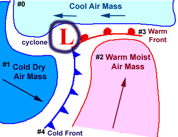
Model of mid. latitude cyclones
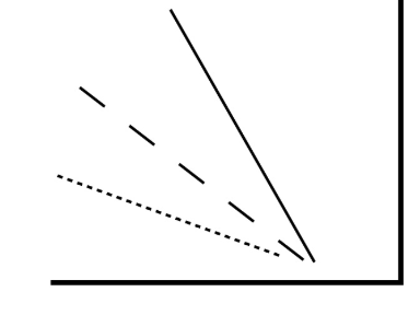
What is the unstable lapse rate? Draw a model.
It’s when the air parcel is warmer than the surrounding air (dashed line is DALR, straight is SDLR, dotted is ELR)
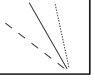
What is stable lapse rate? Draw a model
Air parcel is cooler than surrounding air.
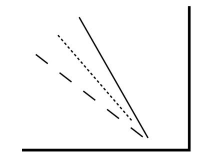
What is conditional instability? Draw a model
Parcel is warming than surrounding air if saturated, cooler if not saturated
Three lifting mechanisms?
Thermal convection
orographic lifting
frontal lifting and convergence
What is the DALR?
5.5º F / 1000 ft
what is the classification system for air masses?
P → Polar
T → Tropical
c → continental
m → maritime
What are the combos for air masses?
cP → dry and cold
mP→ wet and cool
cT→ dry and hot
mT→ humid and warm
What is the casual continuum?
Radiation differences causes temp differences which causes density differences which causes pressure differences, and ultimately causes wind. The wind causes raadiation differences
What is air pressure?
The force exerted against a surface by the continuous collision of gas molecules against the surface
What is net radiation?
The overall gain/loss of energy at Earths surface. Differences between incoming and outgoing radiation
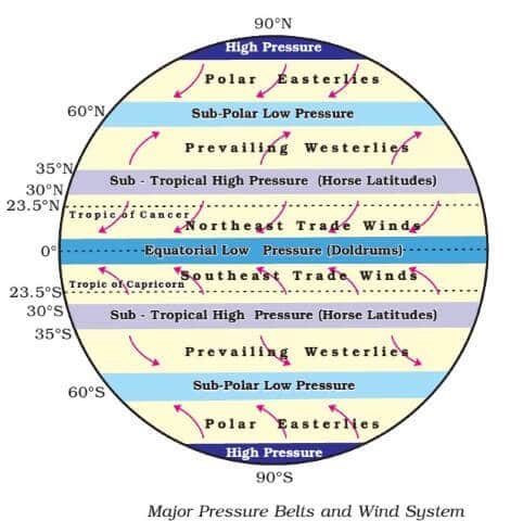
What is the model that shows the band of low and high pressure? Draw it.
Hurricanes: Where do they occur, when do they occur, why do they occur?
Occurs 10º around equator, roughly around late summer early fall because there is still warm water that they need to form
Tornadoes: Where do they occur, when do they occur, why do they occur?
Occur during spring to early summer due to higher sun angles throughout the season, occur in central US
Types of fog? Which are associated w/ cooling? Adding moisture?
Advection (horizontal air movement of warm air over cold surface) → cooling
Radiation (over night cooling net radiation loss) → cooling
Upslope (air forced up a mountain) → cooling
Steam (cold air moving over warm surface ) → adding moisture
Frontal (warm air riding over cold air during warm front) → adding moisture