Hazards
1/75
There's no tags or description
Looks like no tags are added yet.
Name | Mastery | Learn | Test | Matching | Spaced | Call with Kai |
|---|
No analytics yet
Send a link to your students to track their progress
76 Terms
Natural Hazard
The threat of a natural event which has the potential to cause significant social and economic damage. When such event occurs, it is often referred to as a natural disaster.
Event
Any kind of natural process that has no interaction with a population.
Hazard
A natural event which involves a population.
Disaster
21 people must die and damage must total to $25 million for it to be a disaster.
Made by the Swiss Re Insurance Company
Geophysical Hazard
Driven by the Earths internal energy sources.
E.g. Volcanoes & Earthquakes
Atmospheric Hazard
Driven by processes at work within the Earths atmosphere
E.g. Tornadoes & Hurricanes
Hydrological Hazards
Driven by bodies of water, usually oceans
E.g. Floods, Storm Surges, & Tsunamis
Responses to disasters - Fatalistic
An optimistic approach, hazards are gods will and loses are inevitable. People stay where they are.
Responses to disasters - Prediction
Using tech available to them to predict and prepare for the event.
E.g. Weather Forecasts and Seismic Monitoring
Responses to disasters - Adaptation
Implementing strategies to prevent the event becoming a hazard.
E.g. Earthquake proof buildings
Responses to disasters - Risk Sharing
Insurance to ensure that the cost of a hazard is spread between a number of parties
Responses to disasters - Distribution
Higher concentration of events in an area will mean that adaptations will be put in place and communities will be more prepared hence the risk will reducing.
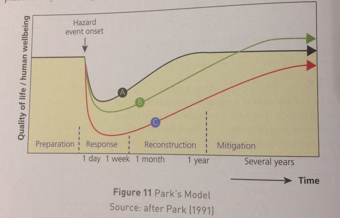
What is the name for this model?
The Park Model
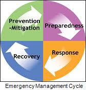
What is the name of this model
The Disaster Management Cycle
What was proposed by Edmond Halley in 1692?
He proposed the Earth consisted of separate layers, unable to accurately describe these layers though.
Lithosphere
The layer of crust and upper most solid mantle about 50-100km of solid rock.
Asthenosphere
The crossover point of the crust and mantle, with a mix between solid rock and molten rock.
Rheid
A substance whose temperature is below the melting point and whose deformation by viscous flow during the time of observation is at least three orders of magnitude (1,000 x) greater than the elastic deformation under the given conditions.
P Waves (Primary/Pressure Waves)
Can travel through liquids and solids, although will be refracted at the boundaries between them.
S Waves (Secondary Waves)
Can only travel through solids.
Crust
Outermost layer between 5-70km thick.
Moho
The boundary between the brittle lithosphere and rheid asthenosphere.
Mantle
2900km thick made of Peridotite and semi-molten rock.
Asthenosphere
This is rheid, can flow over long periods of time due to extreme heat and pressure.
Core
Most central and hottest layer with temperature reaching 5000oC.
Consists of liquid (outer)/solid (inner) Iron and nickel which is 4x the density of the crust.
As the earth rotates, the outer core spins forming a magnetic field.
The main source of heat is known as Primordial Heat whilst some come from Radioactive Decay
Oceanic Plates
Basaltic rock (cooled lava) known as Sima (silica + magnesium) with a density of 3g/cm3 and 5-10km thick.
Continental Plate
Granitic rock (cooled lava) known as Sial (consists of silica and aluminium) with a density of 2.7g/cm3 can be up to 70km thick
Ridge Pull
Occurs at the spreading centres of two plates that are moving away from each other.
Slab Pull
Occurs at the subduction zones where one plate is pulled down into the mantle.
Convection Currents
Radioactive decay of uranium creates heat which causes thermal currents in the asthenosphere to slowly rise. This causes molten rocks to cool and spread apart forming Constructive Plate Boundaries. Molten rocks cool further and sink forming Destructive Plate Boundaries.
Divergent/Constructive Plate Margins
In oceanic areas, sea floors split apart along boundaries forming Mid-Ocean Ridges.
In continental areas, stretching and collapsing of the crusts create Rift Valleys.
New Crust is formed at the margins as magma rises to fill the gap created.
Convergent/Destructive Plate Margins
When oceanic meets continental, the denser oceanic plate is subducted.
When oceanic meets oceanic, the older and denser plate is subducted.
When continental meets continental, the plates cause the crust to buckle forming fold mountains.
Hotspots/Magma Plumes
Areas of magma rising up from the lower mantle to the crust, believed to be relatively stationary.
As tectonic plates move over these spots, a chain of volcanoes can form at the surface.
E.g. The Hawaiian Islands.
East African Rift Valley
The developing plate boundaries forming along the divergent African (Nubian) Plate and the Arabian and Somalian Plate. The Valley will eventually cause Somalia, part of Ethiopia, and part of Kenya to split off into an island.
Horst
a section of crust that has been lifted relative to the blocks on either side, which is a result of its bounding faults dipping away from each other.
Horsts can form features such as plateaus, mountain ranges or ridges on either side of the valleys, and are usually formed next to Grabens.
Grabens
A graben is a section of crust that has lowered relative to the blocks on either side, which is a result of its bounding faults dipping towards each other.
Graben form low-lying features such as basins and rift valleys. They can be very long relative to their width, and are usually formed next to Horsts.
Islands Arc
Tend to form at convergent plate boundaries
Convection currents is the process involved in their creation
Crusts descends into the mantle along the lithosphere as it folds, crumples and is forced up
Heating occurs along the subduction zone
Magma effecting the type of volcano
When magma erupts at the surface as lava, the type of volcano formed depends on: the viscosity (stickiness) of the magma, the volume of gas in the magma, the composition of the magma, the way magma reached the surface.
Effusive
A type of volcanic eruption where low-viscosity (runny) lava flows out of a volcano onto the ground, rather than being explosively ejected into the atmosphere.
Characteristics of a Divergent plate eruption
Low pressure
High temperature
High gas release
Low heat transfer to the crust
Highly effusive eruptions
Characteristics of a Convergent plate eruption
High pressure
Low temperature
Low gas release
Low heat transfer to crust
Highly explosive eruptions
Active Volcano
Recent history of eruptions, likely to erupt again.
Dormant Volcano
Hasn’t erupted in a long time but may do in the future.
Extinct Volcano
Not expected to erupt in the future.
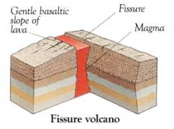
Fissure Volcano
A gentle slope of basaltic lava with low silica content.
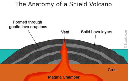
Shield Vocalno
Gentle slope of basaltic lava flow, with a low silica content.
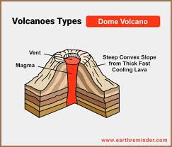
Dome Volcano
Stepp convex slopes from thick, fast cooling lava, with a high silica content.
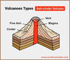
Ash Cinder Volcano
Fine ash released from a cinder vent, with a low silica content.
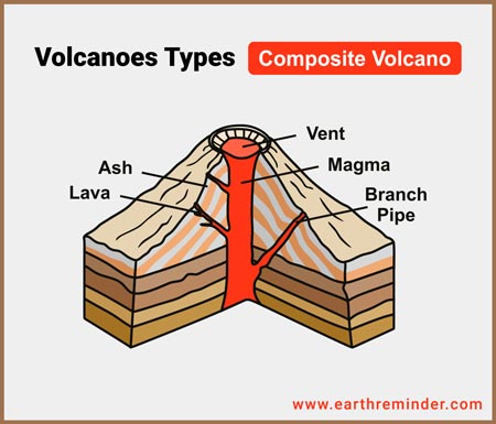
Composite Volcano
Also known as a Stratovolcano, it releases ash and lava with branch pipes of the main vent. They have a high silica content.
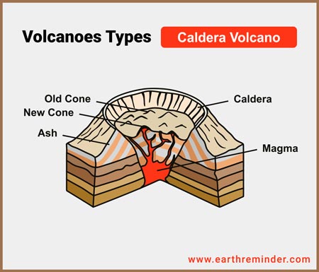
Caldera Volcano
Multiple cones in a large crater releasing ash and magma with a high silica content.
Explosive Eruptions
Can be catastrophic as it erupts between 10-1000km3 of magma per eruption. They send ash clouds more than 25km into the stratosphere.
These have severe environmental and climate impacts whilst also very hazardous.
Stratovolcanoes Characteristics
Its Andesitic Magma is felsic (high silica content) with a high viscosity meaning the magma is very sticky and can’t flow very far. Despite having 30-35o slopes.
These are likely to cause explosive eruptions which may form Caldera Volcanoes.
Shield Volcanoes Characteristics
Its Basaltic Magma is mafic (low silica content) with a low viscosity meaning the magma is very runny and can spread out. Has 10o slopes.
They erupt frequently but not explosively.
Primary Impacts - Lava Flows
Destroy and bury everything in their path but usually slow enough for people to avoid.
Pahoehoe (ropy/smooth) - Basaltic lava can flow at 30km/hr
Aa Lava (blocky/rough) - Flow speed depends on the silica content determining its viscosity.
Primary Impacts - Tephra
Fragments produced during a volcanic eruption.
Ash - <2mm diameter, miles travelled destroying habitats and buildings.
Lapilli - 2-64mm diameter
Volcanic Bombs - >64mm diameter
Primary Impacts - Sulphur Dioxide
Ejected by volcanoes into the stratosphere converts sulphuric acid and condenses into sulphate aerosols. Aerosols increase the radiation reflection from the sun cooling earths Troposphere.
Primary Impacts - Volcanic Bombs
Mass of partially molten rock layer than 64mm, formed when a volcano ejects viscous fragments of lava during an eruption. Lava cools rapidly as it passes through the air.
Types - Almond Bombs, Breadcrust Bombs, Twist Bombs.
Primary Impacts - Flood Basalts
Huge areas of mafic basalt erupted during fissure eruptions, and degassing of lava also releases huge amounts of CO2
E.g. Deccan Traps, India, Covers an area of 500,000km
Primary Impacts - Pyroclastic Flows (Nuees Ardentes)
Fast moving gas and rock called tephra, travelling at speeds of up to 450mpjs and at temperatures of about 1000oC.
Secondary Impacts - Lahars (Mudflow)
Flows of ash, cinder, soil and rock that have been changed to clay by acids from the volcano.
Extremely dangerous.
Secondary Impacts - Tsunamis
Several types of volcanic activity can displace enough water to generate destructive tsunamis.
Secondary Impacts - Noxious Gas, Lake Nyos, Cameroon
1,700 people living in a valley below Lake Nyos in North-western Cameroon mysteriously died in the evening of the 26th August 1986.
Lake Nyos is a crater inside a dormant volcano which became laden with CO2 suddenly bubbled out of the lake and asphyxiated nearly every living being in the surrounding valley.
A management plan has been developed to remove gas from the lake to prevent a further tragedy. An artificial vent to the lake surface created where it can degas.
Preparedness
The state of readiness for a volcanic eruption
Remote Sensing - How? What does it Indicate?
Satellites, Spacecraft, Aircraft
Detects and monitors physical characteristics of an area by measuring its reflected and emitted radiation
Seismicity - How? What does it Indicate?
Seismometers
The occurrence of seismic activity with plate tectonics
Ground Deformation - How? What does it Indicate?
Global Positioning System (GPS)
The pressure of a volcano as magma under high pressure deforms the ground
Geophysical Measurements - How? What does it indicate?
Range of sensors, navigational equipment, recording systems
The changes in the physical nature of the volcano with the possibility of an eruption occurring in the near future
Hydrology - How? What does it indicate?
Measure discharge of water levels
Describe the quality and quantity of water as it moves through the cycle
Gas - How? What does it indicate?
Measured using Isometrics
How explosive a volcanic eruption will be.
Long Range Forcasts
Based on evidence from the geological record, Pas is used as a key to the future
E.g. Tephra Deposits timing of previous eruptions
Short Range Forecast
Based on evidence from instrumental data, which suggests fairly imminent activity
Stratigraphy
The branch of geology concerned with the order of strata (layers) in the geological timescale
Used to give long range forcasts
Different tephra layers indicate previous eruptions
Can be dated to give an idea of volcanic eruptions frequency
Extrusive
Magma that reaches the earths surface, becoming overrated, cool quickly known as lava.
Intrusive
Magma injected into the crust along cracks and weaknesses, creating Igneous intrusions once cooled (e.g. Granite)
Batholiths
Roughly circular or oval in plan and over 100km long
Usually consists of course grained igneous rock composed of granite
Often underlie and support the most elevated sections of continental margin mountain bells (e.g. Andes)
Isle of Arran, West Scotland’s geology indicates it may have been volcanic with a batholith below it
Monadnock
A mountain that rises out of a surrounding plain that develops because it consists of more resistant rock than the bedrock of the surrounding region.