Chapter 1: This is Geography
1/115
Name | Mastery | Learn | Test | Matching | Spaced | Call with Kai |
|---|
No analytics yet
Send a link to your students to track their progress
116 Terms
Greek Origins of Geography + Definition
Based on two greek words
geo means “Earth”
graphy means “to write”
the study of where things are found on Earth's surface and the reasons for their locations.
Place
A specific point on Earth distinguished by a particular characteristic.
Region
An area of Earth defined by one or more distinctive characteristics.
Scale
The relationship between the portion of Earth being studied and Earth as a whole.
Space
The physical gap or interval between two objects.
Connection
Relationships among people and objects across the barrier of space.
Purpose of a Map in Geography
To display and analyze the distribution of features across Earth
Cartography
Science of Mapmaking
GIS
Geographic Information System
captures, stores, queries, and displays the geographic datacaptures, stores, queries, and displays the geographic data
Photogrammetry
The science of taking measurements of Earth’s surface from photographs
Remote Sensing
The acquisition of data about Earth’s surface from a satellite orbiting Earth or from other long-distance method
GIScience + Purpose
analysis of data about Earth acquired through satellite and other electronic information technologies.
helps geographers create more accurate and complex maps and measure changes over time in the characteristics of places
enables geographers to calculate whether relationships between objects on a map are significant or merely coincidental
GPS
Global Positioning System
a system that determines the precise position of something on Earth.
Purpose of GPS in Navigation
Determines the precise position of something on Earth
Navigation
accurately making sure of one’s position and planning and following a route
Geotagging
identification and storage of a piece of information by its precise latitude and longitude coordinates
VGI
Volunteered Geographic Information
Creation and dissemination of geographic data contributed voluntarily and for free by individuals.
Citizen Science
scientific research by amateur scientists
Participatory GIS
Community-based mapping, representing local knowledge + information
mashup
a map that overlays data from one source on top of a map provided by a mapping service, such as Google Maps or Google Earth
What3words
Divides the world into 57 trillion squares, each identified by three English words
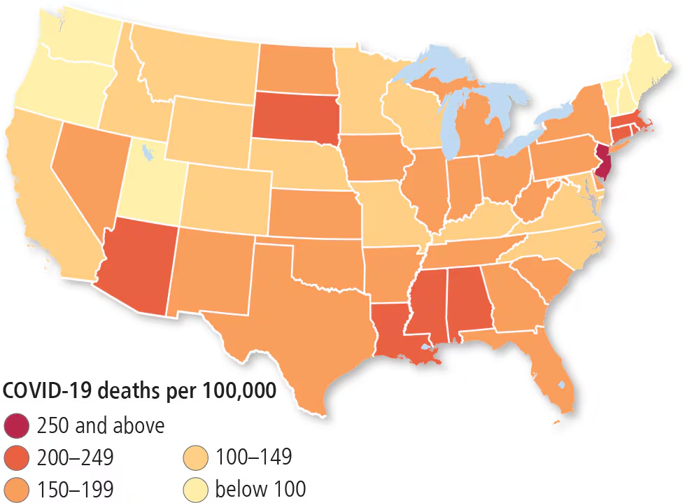
Choropleth Map
recognizable areas are shaded or patterned in proportion to the data collected.
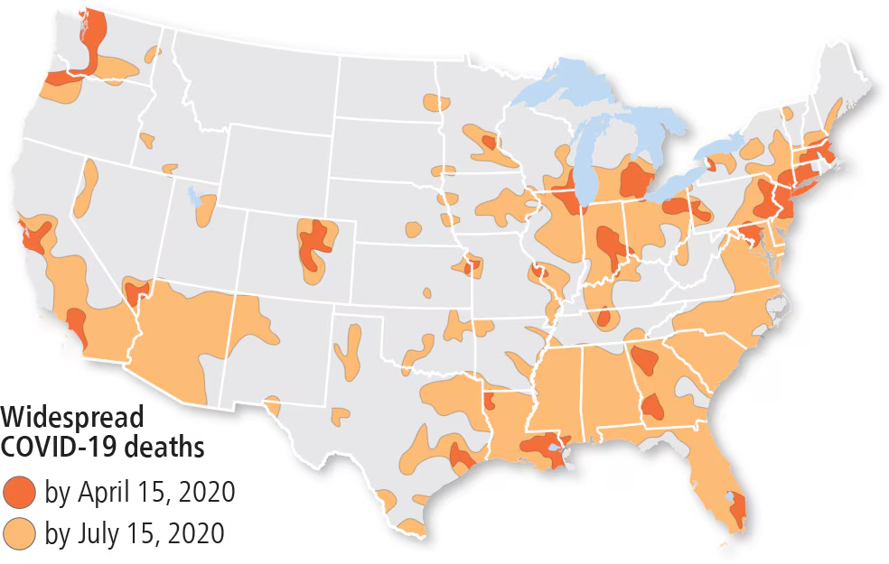
Isoline/isopleth map
connects places of a particular value by lines/areas.
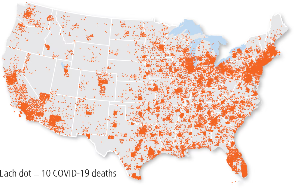
Dot distribution map
depicts data as points and shows how those points are clustered together or spread out over an area. Each dot represents a predetermined number of observations, which could be one or many
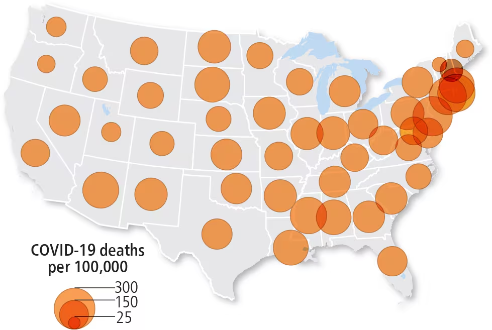
proportional/graduated symbol map
displays symbols that chance in size according to the value of the variable
Cartogram map
the projection and scale of a map is distorted in order to convey the information of a variable
Latitude
The numbering system used to indicate the location of parallels drawn on a globe and measuring distance north and south of the equator (0°).
Longitude
The numbering system used to indicate the location of meridians drawn on a globe and measuring distance east and west of the prime meridian (0°).
Meridians
An arc drawn on a map between the North and South poles.
Prime Meridian
The meridian, designated as 0° longitude, that passes through the Royal Observatory at Greenwich, England.
UTC
Coordinated Universal Time
The time in the zone encompassing the prime meridian, or 0° longitude.
International Date Line
An arc that for the most part follows 180° longitude. When the International Date Line is crossed heading east (toward America), the clock moves back 24 hours, or one entire day. When it is crossed heading west (toward Asia), the calendar moves ahead one day.
How many Time Zones are there
24
How much does each time zone cover the earth?
15 degrees
Time zones
24 time zones that cover 15o of longitude each
Map Scale
the relationship of a feature’s size on a map to its actual size on Earth
Ratio map scales
ratio or fraction shows a numerical relationship between distances on the map and Earth’s surface. A scale of 1:1,000,000 means that 1 unit (such as inch or centimeter) on the map represents 1 million of the same unit on the ground.
Written Map Scales
A written scale describes the relationship between map and Earth distances in words. For example, in the statement “1 centimeter equals 10 kilometers,” the first number refers to the map distance and the second to the actual distance on Earth’s surface.
Graphic Map Scales
graphic scale usually consists of a bar line on a map to represent distance on Earth’s surface. To use a bar line, first determine with a ruler the distance on the map in inches or centimeters from one place to another. Then hold the ruler against the bar line and read the number on the bar line opposite the map distance on the ruler. The number on the bar line is the equivalent distance on Earth’s surface.
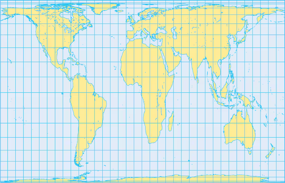
Gall-Peters Projection
This projection distorts shape but not size
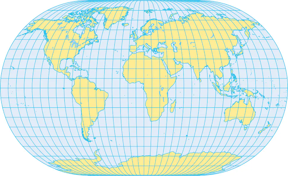
Mercator Projection
has little distortion of shape but distorts size. In a Mercator projection, areas near the poles appear much larger than they actually are.
Winkel Projection
The relative sizes of the land masses on the map are the same as in reality. However, by allocating space to the oceans, the land areas are much smaller than on interrupted maps of the same size.
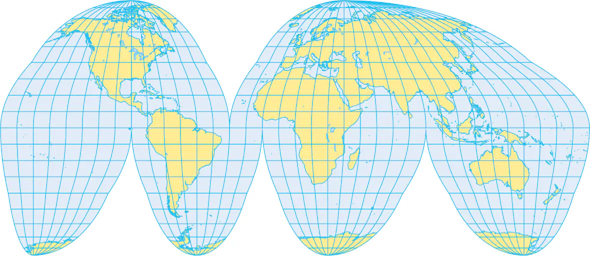
Goode Homolosine Projection
This separates the hemispheres into two pieces. The meridians do not converge at the poles as they do in reality. Also, they do not form right angles with the parallels.
Location
The position of anything on Earth’s surface.
Absolute Location
specific, fixed point on the Earth's surface as expressed by a scientific coordinate system
Relative Location
describes a place’s position in relation to other landmarks or known places
Absolute Direction
fixed directions that always point in the same direction, regardless of location (north/south/east/west)
Relative Direction
describe the position of one point relative to another (right, left, backward, up, etc.)
Absolute Distance
exact measurement of the physical space between two locations
Relative Distance
a measure of the social, cultural, and economic relatedness or connectivity between two places,
Sense of Place
a feeling for the features that contribute to the distinctiveness of a particular spot on Earth
Perceptual region
An area that people believe exists as part of their cultural identity.
Accessibility
important aspect of situation as some places are important because they are accessible to other places
For example, because of its situation, Cairo has become a center for the trading of goods and culture among Africa, Europe, and Asia
Toponym
The name given to a place on Earth
4 reasons people change toponyms
A place may be named for a person, perhaps its founder or a famous person with no connection to the community
Some settlers selected place names associated with religion, such as St. Louis and St. Paul
other names derive from ancient history, such as Athens, Attica, and Rome, or from earlier occupants of the place
Government/citizen (social) preferences
Site
The physical character of a place
climate, water sources, topography, soil, vegetation, latitude, and elevation. The combination of physical features gives each place a distinctive character.
Factors into selecting locations for settlementsThe location of a place relative to another place.
Situation
The location of a place relative to another place.
Situation helps us find an unfamiliar place by comparing its location with a familiar one. We give directions to people by referring to the situation of a place: “It’s down past the courthouse, beside the large elm tree.
Situation helps us understand the importance of a location. Many places are important because they are accessible to other places.
Natural Landscape
Physical naturat features of a landscape
Cultural Landscape
combination of cultural features such as language and religion, economic features such as agriculture and industry, and physical features such as climate and vegetation, possessing not a single human or environmental characteristic but a combination of them.
Formal Region
area within which most people share one or more distinctive characteristics.
Countries/U.S. States
Functional Region
An area organized around a node or focal point
diminishes in importance outward. The region is tied to the central point by transportation or communications systems or by economic associations
area of reception of broadcast signals from a TV station
Perceptual/Vernacular Regions
area that people believe exists as part of their cultural identity.
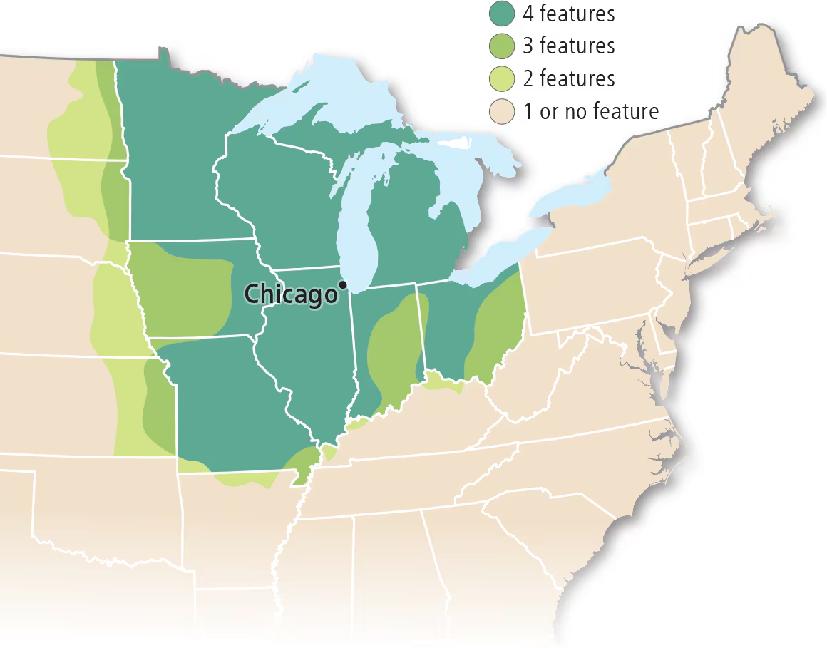
U.S. Midwest
Mental Map/Activity Space
A representation of a portion of Earth’s surface based on what an individual knows about a place that contains personal impressions of what is in the place and where the place is located.
Spatial Association
The relationship between the distribution of one feature and the distribution of another feature.
Spatial Interaction
The deliberate movement of goods, people, or information from one place to another place.
Globalization
actions or processes that involve the entire world and result in making something worldwide in scope
Transnational Corporations
A company that conducts research, operates factories, and sells products in many countries, not just where is headquarters or shareholders are located
Globalization of Culture
Increasingly uniform cultural preferences produce uniform “global” landscapes of material artifacts and of cultural values. Fast-food restaurants, service stations, and retail chains deliberately create a visual appearance that varies among locations as little as possible.
How Globalization affects local diversity
The survival of a local culture’s distinctive beliefs, forms, and traits may be threatened by interaction with such social customs as wearing jeans and Nike shoes, consuming Coca-Cola and McDonald’s hamburgers, and communicating using cell phones and computers.
Distribution
The arrangement of something across Earth’s surface
Density
The frequency with which something exists within a given unit of area.
Concentration
The extent of a feature’s spread over a given area
Pattern
The geometric or regular arrangement of something in a particular area.
Social Distance
increasingly uniform cultural preferences produce uniform “global” landscapes of material artifacts and of cultural values. Fast-food restaurants, service stations, and retail chains deliberately create a visual appearance that varies among locations as little as possible.
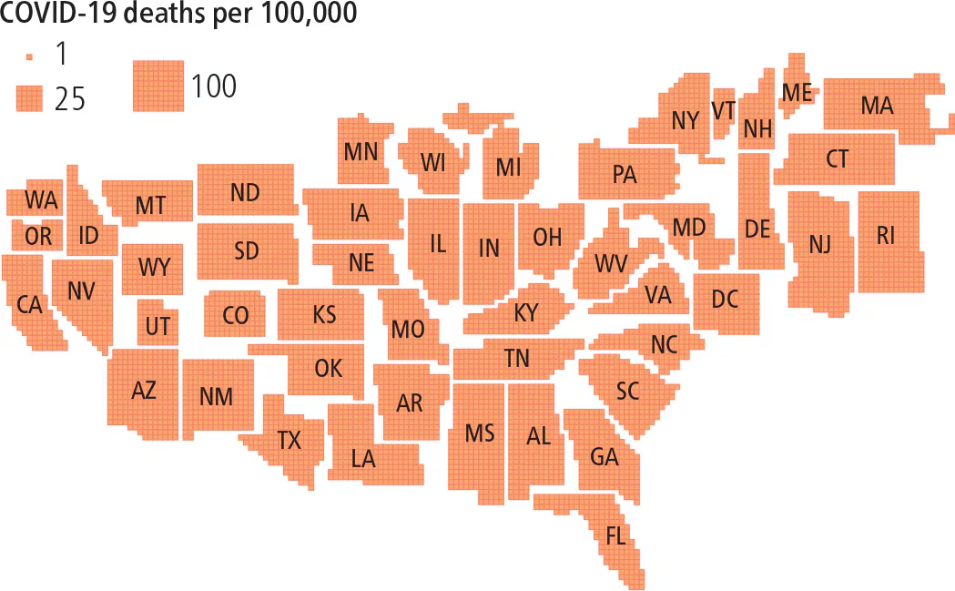
To stem the spread of a contagious, airborne disease such as COVID-19, the number of people in the same space must be limited—that is, the density reduced
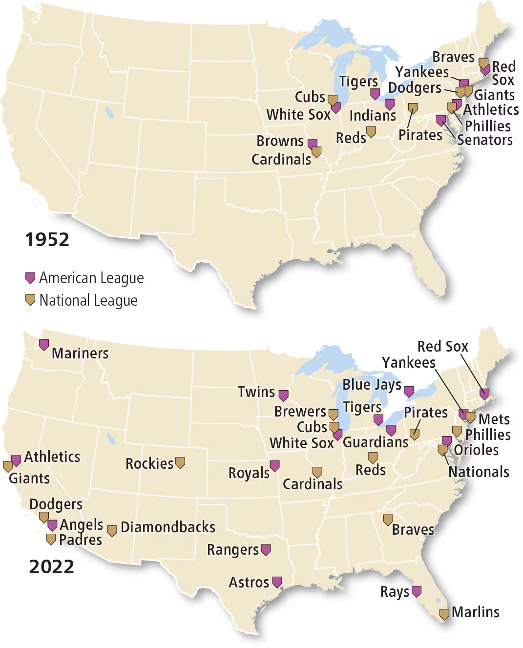
Distribution: Major League Baseball
illustrates the difference between density and concentration
Distribution: Black Lives matter
Movement that campaigns against violence and perceived racism toward Blacks and educates others about the challenges that Black Americans continue to face in the United States.
Distribution by sexual orientation, spatial interaction, LGBTQ and sexual orientation distribution in the United States and worldwide (what affects the distribution worldwide? What are the general patterns?)
Different locations are safer for community than others
Gender Roles
beliefs about males and females that are passed from generation to generation through processes of socialization
Gender Relations
social relations between and among people that are based on gender norms and roles.
Can create hierarchies b/w and among groups that can lead to unequal power (one group above the other)
Gender Equality
equal chances or opportunities for females to access and control social, economic, and political resources
Gender equity
equal chances or opportunities for females to access and control social, economic, and political resources
Uneven Development
The increasing gap in economic conditions between regions in the core and periphery that results from the globalization of the economy
Core Areas
regions that are economically dominant, often characterized by high levels of industrialization and wealth.
(North America, Europe, East Asia)
Periphery Areas
regions that are economically disadvantaged, often reliant on core areas for trade and resources.
(Developing Nations)
Hearth
A place from which an innovation originates.
Diffusion
The process of spread of a feature or trend from one place to another over time.
Stimulus Diffusion
The spread of an underlying principle even though a specific characteristic is rejected.
Hierarchical diffusion
The spread of a feature or trend from one key person or node of authority or power to other persons or places.
Expansion Diffusion
The spread of a feature or trend among people from one area to another in an additive process.
Relocation Diffusion
The spread of a feature or trend through the physical movement of people from one place to another, carrying their culture or ideas with them.
Distance Decay
The diminished importance and eventual disappearance of a phenomenon with increasing distance from its origin.
Space-Time Compression
describe the reduction in the time it takes for something to reach another place
Assimilation
a group’s cultural features are altered to resemble those of another group. The cultural features of one group may come to dominate the culture of the assimilated group.
Acculturation
process of changes in culture that result from the meeting of two groups. Changes may be experienced by both of the interacting cultural groups, but the two groups retain distinct cultures.
Syncretism
Combination of elements of two groups into a new cultural feature. The two cultural groups come together to form a new culture.
Network
A chain of communication that connects places
Sustainability
The use of Earth’s renewable and nonrenewable natural resources in ways that do not constrain resources use in the future
3 Pillars of Sustainability
Environmental Pillar
The sustainable use and management of Earth’s natural resources to meet human needs such as food, medicine, and recreation is conservation. Resources such as trees are conserved if they are cut down at a slower rate than the time it takes for their replacement by new tree growth
Social Pillar
Humans need shelter, food, and clothing to survive, so they make use of resources to meet these needs. Consumer choices can support sustainability when people embrace sustainability as a value. For example, a consumer might prefer clothing made of sustainable resources such as cotton instead of clothing made of unsustainable resources such as polyester made from petroleum. A consumer might also choose products that benefit people living in a particular