MODELS AND OTHER THINGS THAT MUST BE REMEMBERED FOR SURE!!!
1/72
Earn XP
Description and Tags
Flashcards covering key concepts from demographic and social models outlined in the lecture notes.
Name | Mastery | Learn | Test | Matching | Spaced | Call with Kai | Chat |
|---|
No analytics yet
Send a link to your students to track their progress
73 Terms
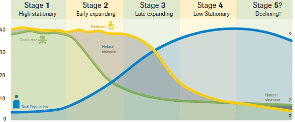
Demographic Transition Model (DTM)
Definition: Shows the 5-stage transition from high birth/death rates to low birth/death rates as a country industrializes.
/
Stage 1 (Low Growth): High CBR, High CDR. No countries (Amazon tribes maybe).
/
Stage 2 (High Growth): High CBR, Rapidly Falling CDR (better medicine/food). Ex: Sub-Saharan Africa, Yemen.
/
Stage 3 (Moderate Growth): Falling CBR, Slowly Falling CDR. With urbanization, fewer children are needed. Ex: Mexico, India.
/
Stage 4 (Low Growth): Low CBR, Low CDR. ZPG (Zero Population Growth). Ex: USA, China.
/
Stage 5 (Decline): Very Low CBR, Low CDR. Aging population, negative NIR. Ex: Japan, Germany.
/
Rules: Developed countries are in later stages; developing countries are in earlier.
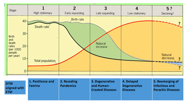
Epidemiologic Transition Model
Definition: Links disease and life expectancy to the DTM.
/
Stage 1: Pestilence and Famine (Infectious disease, plagues). The Black Death (14th Century).
/
Stage 2: Receding Pandemics (Improved sanitation, cholera). 19th-century cholera outbreaks
/
Stage 3: Degenerative Diseases (Heart disease, cancer, aging). Modern-day India or Mexico.
/
Stage 4: Delayed Degenerative Diseases (Medicine delays deaths, Alzheimer’s). The United States, Canada, and Western Europe.
/
Stage 5: Reemergence of infectious diseases (drug resistance, new pandemics). Reemergence of malaria or tuberculosis
Malthusian Theory
Definition: Thomas Malthus (1798) predicted that population grows exponentially ($1, 2, 4, 8$) while food grows arithmetically ($1, 2, 3, 4$), leading to famine/disease.
Neo-Malthusian
A perspective that supports Malthusian theory but emphasizes depletion of various resources, not just food.
Boserup Hypothesis
Definition: Contrary to Malthus, says that population growth stimulates food production. (Technological impact)
\
"Necessity is the mother of invention".
\
Example: Green Revolution.
Ravenstein's Laws of Migration
Definition: Rules that detail patterns of human migration, particularly economic migration.
Most migrants move a short distance.
Migration happens in steps.
Long-distance migrants go to big cities.
Rural residents are more migratory.
Most migrants are young, single adults (not families).
Women are more migratory than men within their country, but men are more likely to migrate internationally.
Migration increases with the level of economic development.
Migration is often a response to economic opportunities.
Migrants tend to settle in areas with established communities from their origin.
The scale of migration varies inversely with the distance to be traveled.
Economic factors are the primary motivation for migration.
Zelinsky Model of Migration Transition
Definition: Links migration types to DTM stages.
/
Stage 1: Seasonal migration.
/
Stage 2: High international emigration (rural to urban).
/
Stages 3-4: High intraregional migration (cities to suburbs)
/
Stage 4: During stage five "Nearly all residential migration may be of the interurban and intraurban variety
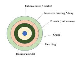
Von Thünen’s Model of Land Use
Definition: Explains agricultural land use based on transportation costs to the market
/
(CBD).
Zones (Center to Outskirts):
1. Market/City
/
2. Dairying/Intensive Farming: Perishable, high transportation cost.
/
3. Forest: Fuel, heavy transport cost.
/
4. Extensive Field Crops: Grain, lower cost, needs space.
/
5. Ranching/Livestock: Needs the largest space, animals can walk to market.
/
Rules: Land is cheapest furthest away.
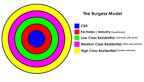
Concentric Zone Model (Burgess)
Definition: Cities grow outward from a Central Business District (CBD) in 5 rings.
/
1. CBD
/
2. Transition Zone (Factory/Slums)
/
3. Low-Class Residential
/
4. Middle-Class Residential
/
5. Commuter Zone.
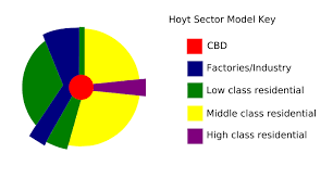
Sector Model (Hoyt’s Model)
Definition: City develops in sectors/wedges, not rings, based on transportation routes and high-rent residential areas.
/
Example: Wealthy areas stretch along a high-income sector (like a scenic route)
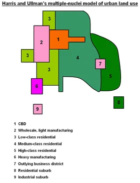
Multiple Nuclei Model (Harris & Ullman)
Definition: Cities have multiple centers (nodes), not just one CBD. Land use is specialized.
/
Example: A city with a university, a factory district, and a commercial center separately.
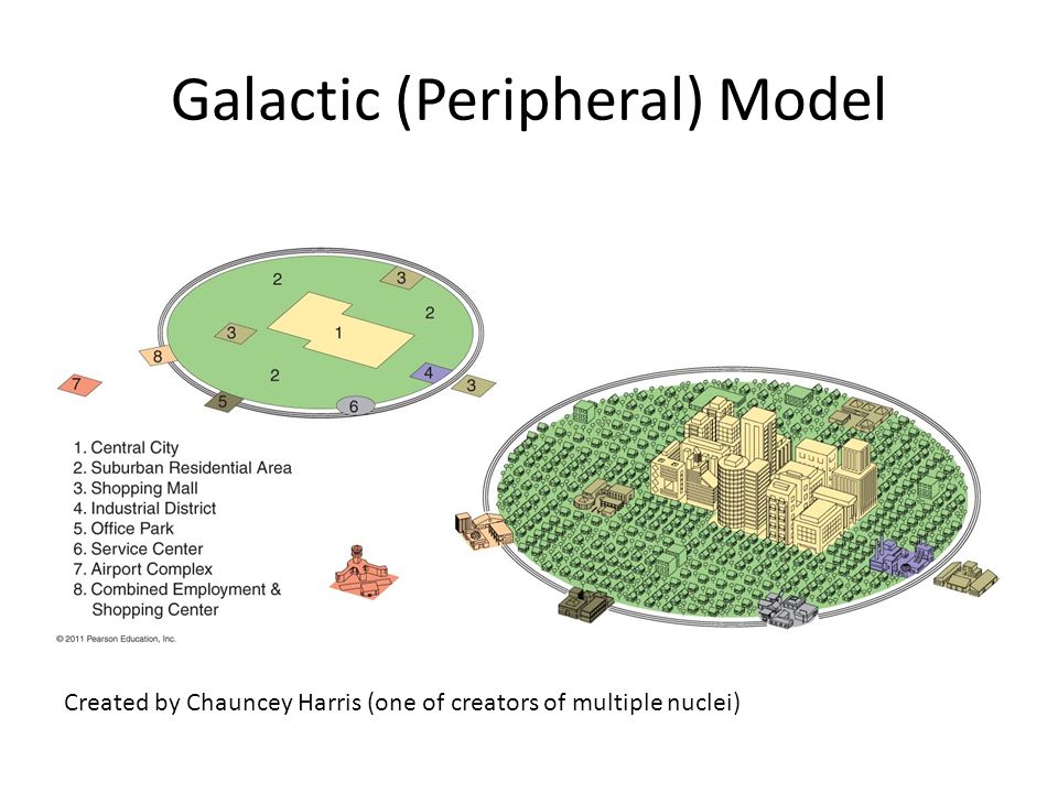
Galactic City Model (Peripheral Model)
Definition: Modern North American city; an inner city surrounded by large suburban areas, connected by a beltway.
/
Example: Edge Cities (e.g., Tysons Corner, VA).
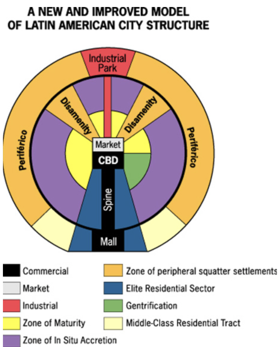
Latin American City Model (Griffin-Ford)
Definition: Combines radial sectors and concentric rings. CBD is center, "spine" of luxury shopping stretches out, "disamenity" zones (slums/favelas) on the edge.
The periferico is the outer ring, characterized by slums.
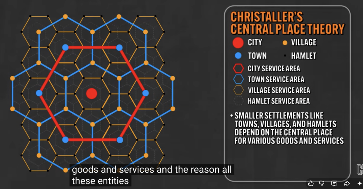
Central Place Theory (Christaller)
Definition: Explains the size and distribution of cities based on market area.
/
Range: Maximum distance people travel for a service.
/
Threshold: Minimum population needed to support a service.
/
Rules: Large cities are far apart; small towns are close together.
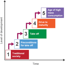
Rostow's Stages of Growth (Modernization)
Definition: A liberal model suggesting all countries can reach high development by passing through 5 stages.
/
1. Traditional Society: Subsistence farming.
/
2. Preconditions for Take-off: Commercialization, infrastructure.
/
3. Take-off: Industrialization, rapid growth.
/
4. Drive to Maturity: Diversification, tech upgrades.
/
5. High Mass Consumption: Service sector dominant, consumer goods.
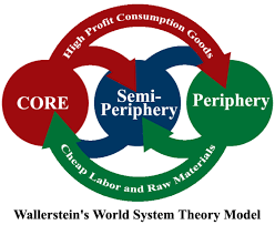
Wallerstein World Systems Theory
Definition: A dependency model (structuralist) that divides the world into three interdependent types:
/
Core: Developed, industrialized, exploit others (USA, Japan).
/
Periphery: Developing, provides raw materials/labor (Sub-Saharan Africa).
/
Semi-Periphery: Developing, industrializing (BRICS - Brazil, Russia, India, China, South Africa).
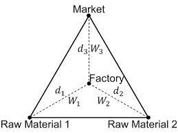
Weber’s Least Cost Theory
Definition: Industries locate where transportation, labor, and agglomeration costs are minimized.
/
Bulk-gaining: Near market (e.g., soft drink bottling).
/
Bulk-reducing: Near raw materials (e.g., copper smelting).
/
Assumptions are that labor and material location is fixed in place, there is only one good produced, transportation costs are directly related to the distance of travel, economic factors dominate the decision about where to locate a factory, and that owners want to minimize costs.
Rate of Natural Increase (NIR)
Calculated as NIR=10CBR−CDR, representing population growth.
Crude Birth Rate (CBR)
Calculated as Total PopulationTotal Births×1,000.
Crude Death Rate (CDR)
Calculated as Total PopulationTotal Deaths×1,000.
Total Fertility Rate (TFR)
Average number of children per woman.
Doubling Time
Calculated as NIR %70, estimating years for a population to double.
Dependency Ratio
Calculated as Working populationNon-working population×100.
Arithmetic Density
Calculated as Total Land AreaTotal Population.
Physiological Density
Calculated as Arable Land AreaTotal Population.
Agricultural Density
Calculated as Arable Land AreaNumber of Farmers.
Human Development Index (HDI
A composite index measuring average achievement in three basic aspects of human development
Health (life expectancy at birth),
Education (mean years of schooling)
Standard of living (GNI per capita).
Gender Inequality Index (GII)
A measure that reflects women's disadvantage in three dimensions:
Reproductive health
Empowerment
Labor market participation.
A higher GII indicates greater inequality between genders.
Primary Sector
The primary sector involves the extraction and harvesting of natural resources, including agriculture, mining, forestry, and fishing. It is focused on providing raw materials directly from the earth.
Secondary Sector
The secondary sector involves the processing and manufacturing of goods, transforming raw materials from the primary sector into finished products. This includes industries such as construction, automotive, and textiles.
Tertiary Sector
The tertiary sector involves the provision of services rather than goods. It includes a wide range of activities such as retail, entertainment, healthcare, and finance, focusing on delivering services to consumers and businesses.
Quaternary Sector
The quaternary sector involves knowledge-based services such as research and development (R&D), financial services, education, and information technology. It focuses on the creation, sharing, and management of information and knowledge.
Quinary Sector
The quinary sector involves high-level decision making and services such as healthcare, education, scientific research, and cultural services. It is characterized by decision-making, leadership, and the provision of specialized services.
Agricultural Hearths
Major agricultural hearths where agriculture first developed include:
Fertile Crescent: Located in the Middle East, where early agricultural practices began, notably with wheat and barley.
East Asia: Known for rice cultivation, which has been integral to the region's diet and culture.
Southeast Asia: The region is significant for the domestication of various crops, including rice and root vegetables.
South Asia (Indus Valley): One of the world’s earliest urban societies, where crops such as barley and wheat were cultivated.
Mesoamerica: Recognized for the domestication of crops like maize, beans, and squash, which played a vital role in the region's development.
Urbanization Hearths
Major urbanization hearths where cities and complex societies first developed include:
Mesopotamia: Located between the Tigris and Euphrates rivers, it is often considered the cradle of civilization with early city-states.
Nile River Valley: The fertile banks of the Nile allowed for the rise of ancient Egyptian civilization and its monumental architecture.
Indus River Valley: Known for its advanced urban planning, including well-planned cities like Harappa and Mohenjo-Daro, it developed along the Indus River in present-day Pakistan.
Huang He (Yellow River) Valley: The cradle of Chinese civilization, where agrarian communities developed into cities along the river's basin.
Mesoamerica: Recognized for early urban centers such as Teotihuacan and Tikal, with complex societies based on agriculture and trade.
Industrialization Hearths
Industrialization hearths are regions where the process of industrialization first began and flourished, leading to significant economic and social transformations. Major industrialization hearths include:
Great Britain: Often credited as the birthplace of the Industrial Revolution in the late 18th century, with innovations in textiles and steam power.
Northwestern Europe: Regions like Belgium and France experienced early industrial growth through coal and iron production.
United States: The Industrial Revolution took root in the 19th century, characterized by manufacturing growth in cities like New York, Chicago, and Detroit.
Japan: Rapid industrialization occurred in the late 19th to early 20th century, marked by modernization and technological advancement.
China: In recent decades, China has emerged as a major industrial power, with significant manufacturing and export capabilities.
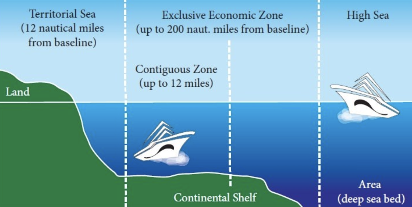
Exclusive Economic Zone (EEZ)
A sea zone prescribed by the United Nations Convention on the Law of the Sea, extending 200 nautical miles from the baseline of a coastal state, within which the state has special rights regarding the exploration and use of marine resources, including energy production from water and wind.
Expansion Diffusion
The spread of a feature or trend among people from one area to another in an additive process. This includes:
Contagious Diffusion: Rapid, widespread diffusion of a feature or trend throughout the population (e.g., the spread of viral videos).
Hierarchical Diffusion: The spread of an idea from persons or nodes of authority to other persons or places (e.g., fashion trends that start in major cities and move to smaller towns).
Relocation Diffusion
The spread of a feature or trend through the physical movement of people from one place to another (e.g., immigrants bringing their cultural practices to a new location).
Stimulus Diffusion
The spread of an underlying principle, even though a specific characteristic is rejected (e.g., the adoption of McDonald's fast-food culture in India, where beef is not served).
Contagious Diffusion
Rapid, widespread diffusion of a feature or trend throughout the population (e.g., the spread of viral videos).
Hierarchical Diffusion
The spread of an idea from persons or nodes of authority to other persons or places (e.g., fashion trends that start in major cities and move to smaller towns).
Reverse Hierarchical Diffusion
The spread of an idea or feature from lower social classes to higher social classes (e.g., hip hop culture initially spreading from urban areas to become mainstream).
Geometric Boundaries
Boundaries that are defined by geometric shapes, often straight lines, irrespective of the natural or cultural features of the area (e.g., the boundary between the United States and Canada along the 49th parallel).
Physical Boundaries
Boundaries that are created by natural features of the landscape, such as rivers, mountains, or lakes (e.g., the Himalayas forming a boundary between India and China).
Cultural Boundaries
Boundaries that are based on cultural differences such as language, religion, or ethnicity (e.g., boundaries between different tribal areas in Africa).
Political Boundaries
Boundaries established by political agreements or treaties, often reflecting the control of particular governments or nations (e.g., international borders agreed upon by treaties).
Definitional Boundary Dispute
Disagreement over the meaning of the boundary, often based on written agreements or legal terms.
Locational Boundary Dispute
Disagreement over the actual location of a boundary, which can arise from maps or geography.
Operational Boundary Dispute
Disagreement on how a boundary should function, often involving how parties use the boundary for access or security.
Allocational Boundary Dispute
Dispute over resources that lie within or across a border, such as water or minerals, often involving claims to those resources.
Political Map
A political map displays the governmental boundaries of countries, states, and counties, as well as major cities and capitals. These maps provide insight into the political divisions and relationships between different regions, showcasing the arrangement of governance at various scales.
Physical Map
A physical map highlights the natural landscape of an area, using colors and shading to depict various physical features like mountains, valleys, plains, and bodies of water. These maps help users visualize the topography and elevation of regions, illustrating the Earth's terrain and geographical features.
Topographic Map
A topographic map is a detailed and precise representation of an area's terrain. It employs contour lines to depict elevation changes, showing the physical landscape's shape and relief. Topographic maps are essential for activities like hiking, urban planning, and environmental studies by illustrating both natural and human-made features on the earth's surface.
Thematic Map
A thematic map is designed to highlight a particular theme or subject, such as climate, population density, or economic activity. Unlike general reference maps, thematic maps focus on specific data and visual patterns, employing various symbols, colors, and designs to effectively communicate information related to that theme.
Choropleth Map
A choropleth map is a specific type of thematic map that uses different shades or patterns within defined areas to represent the distribution of a particular variable, like population density or average income. This type of visualization allows for easy comparison of data across regions, making it a useful tool for analyzing spatial trends and patterns.
Dot Map
A dot map uses dots to signify the presence or quantity of a particular phenomenon within a specified area, such as population density or resource distribution. Each dot may represent a fixed number of occurrences, providing a visual representation that can convey the density and distribution patterns of elements of interest across the landscape.
Flow Map
A flow map visually represents the movement of people, goods, or ideas between locations using arrows or lines. These maps can illustrate the volume and direction of flows, highlighting connections and patterns in migration, trade routes, or transportation systems. Flow maps are essential in understanding how different regions are interconnected.
Goode Homolosine Projection
An equal-area projection that minimizes distortion for area, making it useful for displaying global data such as population or land use.
Winkel Tripel Projection
A projection that balances distortions of area, direction, and distance, making it a good compromise for visualizing the world.
Mercator Projection
A cylindrical map projection that preserves angles and shapes, but distorts areas, especially near the poles, making it useful for navigation.
Robinson Projection
A map projection that attempts to minimize errors in area, shape, distance, and direction, providing a visually appealing representation of the world, often used in world maps.
Peters Projection
An equal-area projection that focuses on preserving land area but distorts shapes, making regions such as Africa and South America appear larger than in other projections.
Azimuthal Projection
A projection that shows the earth on a flat surface, allowing for accurate distances from a central point, often used for air travel maps.
United Nations (UN)
A global organization founded in 1945 with 193 member states aimed at promoting international peace and security, fostering cooperation among nations, and addressing global issues.
European Union (EU)
A political and economic union of 27 European countries that promotes regional integration, economic cooperation, and the establishment of a single market.
North Atlantic Treaty Organization (NATO)
A military alliance established in 1949 for mutual defense, comprising 30 member countries from North America and Europe.
NAFTA/USMCA
North American Free Trade Agreement (NAFTA), replaced by the United States-Mexico-Canada Agreement (USMCA), which aims to eliminate trade barriers between the U.S., Canada, and Mexico.
Association of Southeast Asian Nations (ASEAN)
A regional organization comprising ten Southeast Asian countries that promotes political and economic cooperation.
Organization of the Petroleum Exporting Countries (OPEC)
An intergovernmental organization of oil-exporting nations that coordinates and unifies the petroleum policies of its member countries to ensure stable oil prices.
Bosch ProWG SMM
A professional product line developed by Bosch, focusing on innovative solutions in various fields such as technology and engineering.
Domestication of Plants
The cultivation of wild plants for human consumption, leading to increased reliance on humans and improved yields.
Fertile Crescent: First areas for cultivating wheat and barley.
East Asia: Recognized for rice cultivation.
Southeast Asia: Significant for root vegetable domestication.
South Asia (Indus Valley): Noted for barley and wheat cultivation.
Mesoamerica: Known for maize, beans, and squash domestication.
Domestication of Animals
The process of adapting wild animals for human use, leading to changes in behavior and physiology. Major domestication hearths include:
Fertile Crescent: First domestication of sheep, goats, and cattle.
East Asia: Notable for pig and chicken domestication.
South Asia: Recognized for cattle and elephant domestication.
Mesoamerica: Known for turkeys and ducks.
North America: Features the domestication of llamas and alpacas.