Urban environments IB Geo
1/65
There's no tags or description
Looks like no tags are added yet.
Name | Mastery | Learn | Test | Matching | Spaced | Call with Kai |
|---|
No analytics yet
Send a link to your students to track their progress
66 Terms
What is the site of an urban place?
The physical ground where the settlement is located.
What is the function of an urban place?
Main activities like residential, commercial, or industrial.
What is land use in an urban place?
How land is utilized (e.g., housing, shops, or factories).
What is the hierarchy of settlements?
From small towns to megacities, based on importance and population.
What is the growth process in urban places?
Growth can be planned (organized expansion) or spontaneous (unplanned growth).
How do physical factors affect urban economic activity?
Accessibility and terrain can influence economic activities.
How do land values influence urban economic activity?
Higher land values are found closer to the CBD.
How does proximity to the CBD affect economic activity?
Central locations attract commerce and business.
How does planning influence urban economic activity?
Zoning laws and city design impact the distribution of activities.
How do physical factors shape residential patterns?
Water bodies and terrain often determine where people live.
How do land values influence residential patterns?
Wealthier people often live further from the CBD in MEDCs.
How does ethnicity affect residential patterns?
Cultural clusters (e.g., Chinatown) form based on shared identity.
How does planning shape residential patterns?
Housing policies and urban planning create specific residential zones.
What are economic indicators of urban poverty?
Unemployment and low income.
What are social indicators of urban poverty?
Poor health and high crime rates.
What are physical indicators of urban poverty?
Overcrowding and poor housing conditions.
What are environmental indicators of urban poverty?
Noise and air pollution levels.
What causes urbanization?
Rural-urban migration and better job opportunities in cities.
What causes natural increase in cities?
Youthful populations and higher birth rates.
What is rural-urban migration?
Movement of people seeking jobs and services in cities.
What is gentrification?
Wealthy residents redeveloping inner-city areas.
What is reurbanization?
Revitalization of decayed urban areas.
What is suburbanization?
The shift of people to suburban areas.
What is counter-urbanization?
Movement of people to rural areas.
What is urban sprawl?
Uncontrolled city expansion into rural areas.
What are examples of transport network improvements?
Expanding public transport and road systems.
Why is sanitation and waste management important?
To prevent pollution and improve public health.
How can access to water and electricity be improved?
Investing in infrastructure to meet urban demands.
How can telecommunications infrastructure be enhanced?
Expanding internet and mobile network coverage.
How does globalization cause deindustrialization?
Cheaper labor overseas attracts manufacturing.
How does automation contribute to deindustrialization?
Machines replace human workers, reducing jobs.
How does a decline in manufacturing demand cause deindustrialization?
Changes in technology reduce the need for certain goods.
How do political changes lead to deindustrialization?
Policies like free trade expose industries to competition.
What is an urban heat island?
Cities are warmer than rural areas due to heat retention by buildings.
How does lack of vegetation affect urban microclimates?
Less evapotranspiration leads to higher temperatures.
How does air pollution modify urban climates?
Pollution traps heat, exacerbating warming.
How are emissions standards used to manage air pollution?
By limiting pollutants released by vehicles and factories.
How does public transport reduce air pollution?
It decreases the number of private cars on roads.
How does renewable energy help manage air pollution?
It reduces reliance on fossil fuels.
What are the impacts of traffic congestion on health?
Increased stress and higher risk of respiratory diseases.
How does traffic congestion affect travel costs?
Fuel wastage and longer commutes increase expenses.
What is slum clearance?
Redevelopment projects that remove informal settlements.
How does urban development deplete green spaces?
Construction projects replace parks and open areas.
What is the cycle of deprivation?
Poverty perpetuated by low income, poor education, and inadequate housing.
What are common indicators of deprivation?
High crime rates, poor health, and overcrowded housing.
What is resilient city design?
Strategies to adapt to climate risks, such as better infrastructure.
What is eco-city design?
Minimizing ecological footprints with sustainable practices.
What is a smart city?
Using technology to improve city services and efficiency.
What are expected urban trends by 2050?
Increase in global urban population to 66% and growth of megacities in developing regions.
What is the difference with site and situation? Give examples of each.
Site refers to the phyiscal characteristics of an area (on a hill that prevents flood), while situation is like “located on a coastline for intl trade”
Broadly, state the heirarchy of settlements.
small hamlets and villages to towns, cities, and eventually megacities
Where do most megacities form?
Developing areas, especially in asia
Describe the population of mega city dwelllers and why its so high.
Young adults with high birthrates
Positives and negatives to megacities.
High economic input,
crime/pollution
What factors affect the pattern of urban econmic activities?
Planning, proximity to cbd, topography, zoning, property value, accesibility
Where are industrial zones typically located in an urban environment?
On the outskirts of a city, as it has more space, lower property value, and more access to other areas
Where are retail centers typically located in a city?
Retail centers are typically dispersed, however, are highly clustred towards the cbd where people traffic is high and accesibility to public transport is available
What is the monocentric model?
A city structured around a single central business district (CBD) where most commercial activities occur. Industrial areas are typically on the outskirts, and residential zones radiate outward based on income levels.
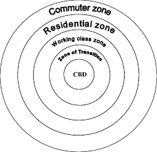
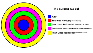
What is the burgess or cocentric model?
A model where a city grows outward from a central CBD in a series of rings, each ring having a specific land use (e.g., industrial, residential).
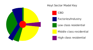
What is the hoyt/sector model?
A model where a city grows in wedge-shaped sectors radiating outward from the CBD, often along major transportation routes. Different sectors accommodate specific land uses, such as residential, commercial, or industrial
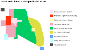
Multiple nucleus model
A model where a city develops multiple centers (nuclei), each focused on specific activities (e.g., commercial, industrial, residential). These nodes arise due to geographic, economic, or historical factors.
Centrifugal Movement
Moving away from urban areas, includes counter urbanization, urban sprawl, suburbanization
Centripretal Movement
Movign towards urban areas, industrialzatoin, urbanization, etc
Re industrialization
Growth
of high-technology industries,
small firms and services
industries.
The highest rates of increase in
small firms are found in the less
industrialized, rural, peripheral
areas rather than large urban
areas with derelict sites.
Positive vs negative deindustrialization
Positive deindustrialization- industries replace theirworkforce with machines, making industry more competitive
Negative deindustrialization- number of workers in anindustry decline but there isno compensating rise inproductivity and mechanization.