AP HUGO Models and missed questions
1/80
There's no tags or description
Looks like no tags are added yet.
Name | Mastery | Learn | Test | Matching | Spaced | Call with Kai |
|---|
No analytics yet
Send a link to your students to track their progress
81 Terms
Cdr decline causes are
Improved healthcare / access to hospitals and medicine Better sanitation and clean water infrastructure Advances in agricultural productivity → reduced famine Public health campaigns (vaccination, disease prevention Improved nutrition and food security Medical technology (antibiotics, surgical advances)
Aging population meaning
Acceptable economic consequences:
Shrinking labor force → reduced economic output
Increased dependency ratio → strain on pension/social security systems
Rising healthcare costs for elderly population
Potential decline in tax revenue
Acceptable social consequences:
Aging population → increased demand for elder care
Changing family structures (smaller families, more single-person households)
Shifting cultural attitudes toward marriage, family, gender roles
Strain on social services, intergenerational tension over resource allocation
Example of superimposed boundary causing problems with possible problems
In Nigeria, the superimposed colonial boundaries forced ethnically and religiously distinct groups into a single state, creating deep internal divisions. The predominantly Muslim Hausa-Fulani north and the predominantly Christian Igbo southeast had little shared political identity. This division directly contributed to the Nigerian Civil War (1967–1970), when the Igbo-majority southeastern region attempted to secede as the independent state of Biafra. The conflict resulted in an estimated one to three million deaths, largely because the colonial boundary had created an artificial state that lacked the internal cohesion needed to manage ethnic competition for political power and oil revenues.
Centripetal+centrifugal forces examples
Acceptable centripetal examples: national anthem/flag, shared language, dominant religion, unifying institutions, national sports teams, common external threat
Acceptable centrifugal examples: ethnic separatism, linguistic divisions, economic inequality between regions, religious conflict, territorial disputes within a state
Devolutionary pressure example
Devolutionary pressures arise when ethnic, linguistic, economic, or geographic differences within a state fuel demands for greater regional autonomy or outright independence, threatening the state's territorial unity. For example, Catalonia in Spain has a distinct language (Catalan), a strong regional economy, and a deep sense of cultural identity separate from the rest of Spain. These factors fueled a 2017 independence referendum — declared illegal by the Spanish central government — demonstrating how devolutionary pressures can directly challenge a state's sovereignty and territorial integrity
Challenges of rapid urbanization in developing countries
Housing shortages → growth of informal settlements / slums
Inadequate infrastructure (water, sanitation, electricity)
Traffic congestion and air pollution
Strain on public services (healthcare, education)
Environmental degradation (waste management, deforestation at urban fringe)
Unemployment / growth of the informal economy
Crime and social inequality
Strategies for sustainable urban development
Investment in public transit / bus rapid transit (BRT) systems
Green building codes and energy-efficient construction
Urban green spaces and parks to reduce heat island effect
Smart growth / mixed-use zoning to reduce sprawl
Waste management and recycling infrastructure
Renewable energy integration in city planning
AP FRQ Writing Formula
Claim (directly answer what's asked) → Evidence (specific data, term, or example) → Connection (explain why/how the evidence supports the claim)
core-periphery model or Wallerstein’s World Systems Theory
describes a spatial structure of economic development where wealthy "core" regions (industrialized, high-tech) dominate and exploit peripheral areas (underdeveloped, resource-dependent). This system thrives on unequal exchange, where the periphery exports cheap raw materials/labor to the core, which sells expensive finished goods back to them, deepening global or regional inequality.
Fair Trade
relates to equity, sustainability, and fair compensation for producers in developing countries (the Global South) exporting to developed nations. It bypasses middlemen to pay higher prices to farmers/artisans, ensuring safe conditions, environmental sustainability, and ethical labor standards.
Arithmetic density
the total population divided by the total land area, typically expressed as people per square kilometer or mile. It measures how crowded a place is, serving as the most common,
Weakness
Does not account for uninhibited land
Physiological density
the number of people per unit area of arable (farmable) land, serving as a key measure of population pressure on food production resources.
Qualitative vs quantitative data
quantitative data uses numerical measurements and statistics to analyze objective patterns (e.g., census, median income), while qualitative data relies on non-numerical information like interviews, descriptions, or visual observations to understand the "why" and "how" behind human experiences
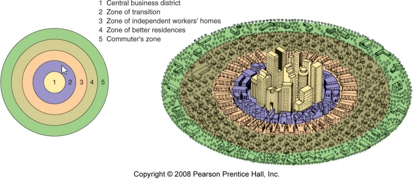
City model showing a city growing outward from the CBD in rings with different land‑use patterns.
City model showing wedge‑shaped sectors developing outward from the CBD along major transportation routes.

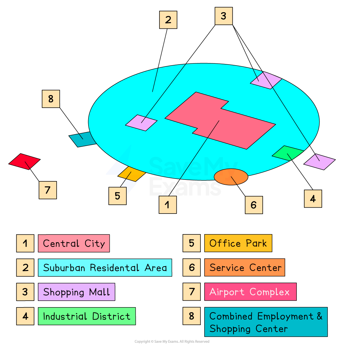
City model showing cities developing multiple focal points (nodes) of activity that interact with one another.

City model describing a traditional downtown surrounded by a loose collection of suburban nodes and edge cities.
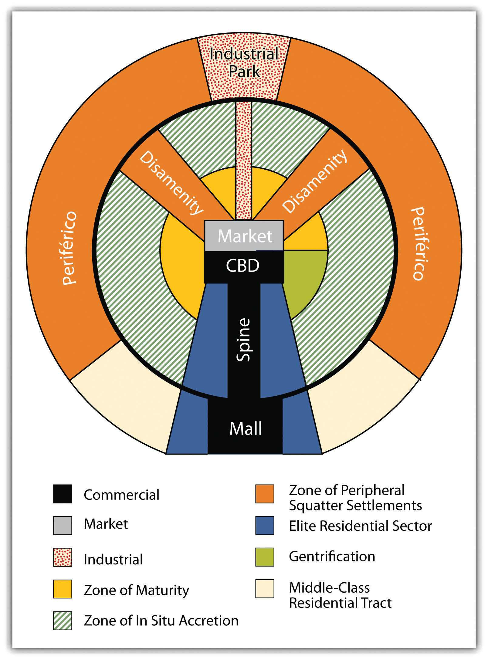
City model placing government, religion, and business at the center with a wealthy “spine” sector and decreasing wealth outward.
City model with multiple CBDs serving different market functions, surrounded by ethnic neighborhoods and informal settlements.
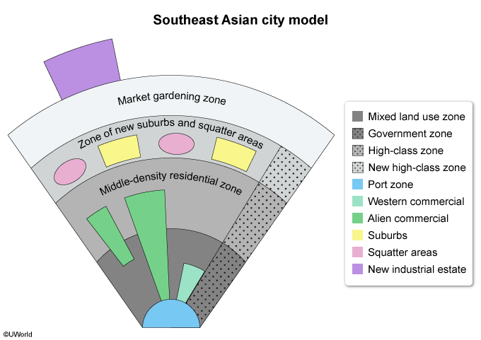
City model centered around a port zone, with surrounding commercial/residential zones and a peripheral ring of market gardening.
Epidemiological Transition Model (ETM)
describes the changing causes of death, mortality, and morbidity within a population, typically moving from high mortality caused by infectious disease to low mortality characterized by chronic, degenerative diseases as a country develops
Demographic Transition Model (DTM)
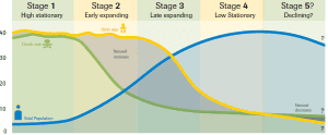
a five-stage framework explaining how populations shift from high birth/death rates to low ones as countries industrialize and develop economically. It is used to analyze current growth and predict future demographic trends, typically moving from high, stable growth (Stage 1) to rapid population expansion (Stage 2 & 3) and finally low, stable, or declining population (Stage 4 & 5)
A cylindrical projection preserving shape and direction, used for navigation but distorts size near poles.

An equal‑area projection that preserves relative size of landmasses but distorts shape, especially near the poles and equator.

A compromise projection that balances shape, size, and distance distortions, often used for world maps.

An equal‑area, interrupted projection that minimizes distortion of landmasses but interrupts oceans, making distance measurement difficult.

neocolonialism
the use of economic, political, or cultural pressure by developed powers to control nominally independent, developing nations, often prioritizing the interests of the dominant nation over the host country. It works through indirect control—such as debt, unequal trade, and international financial institutions—to maintain influence without direct military occupation.
isogloss
a boundary line on a map marking the limit of a specific linguistic feature, such as a particular word, pronunciation, or grammatical structure. They serve to define regional dialects and map linguistic changes across geography.
creole
a stable, fully-fledged natural language that developed from the mixing of different languages, typically during colonial periods. It arises when a simplified contact language (pidgin) becomes the native language of a new generation, developing complex grammar and large, stable vocabularies
Pidgin language
a simplified, makeshift language that develops as a means of communication between groups who do not share a common tongue, typically for trade or survival. It combines elements from multiple languages, often with simplified grammar and vocabulary. Pidgins are not native languages but can evolve into creoles over time
Ethnocentrism
the tendency to view the world primarily through the lens of one’s own culture, judging others by one’s own norms and believing one's group is superior
cultural relativism
the principle that an individual’s beliefs, values, and practices should be understood based on their own culture, rather than judged against the criteria of another.
Universalizing religion
seek global appeal, actively proselytize to convert new members, and transcend specific cultural or geographic boundaries. Key examples include Christianity, Islam, Buddhism, and Sikhism
ethnic religion
faiths closely tied to a specific ethnic group, culture, or geographic region, rather than seeking global converts. They grow primarily through natural increase or relocation diffusion, featuring practices, holy sites, and narratives deeply rooted in their local landscape. Key examples include Hinduism, Judaism, and Shinto
cultural landscape
the visible, tangible imprint of human activity on the natural environment, representing the combined works of nature and humanity
Ravenstein's laws of migration
11 fundamental principles detailing that most migrants move short distances, step-by-step, toward major industrial or economic centers. Key laws include the creation of counter-currents, urban areas attracting more migrants, and economic factors being the primary motivation
malthusian theory
proposed in 1798, argues that population growth will inevitably outrun food supply because population increases geometrically () while food production only increases arithmetically (). This discrepancy leads to catastrophic, natural checks—famine, disease, and war—that forcibly lower the population, keeping humanity in a perpetual state of poverty.
Calculate arithmetic density
total population divided by the total land area.
Transhumance
the seasonal movement of livestock (typically sheep, goats, and cattle) between fixed summer and winter pastures to ensure adequate grazing.
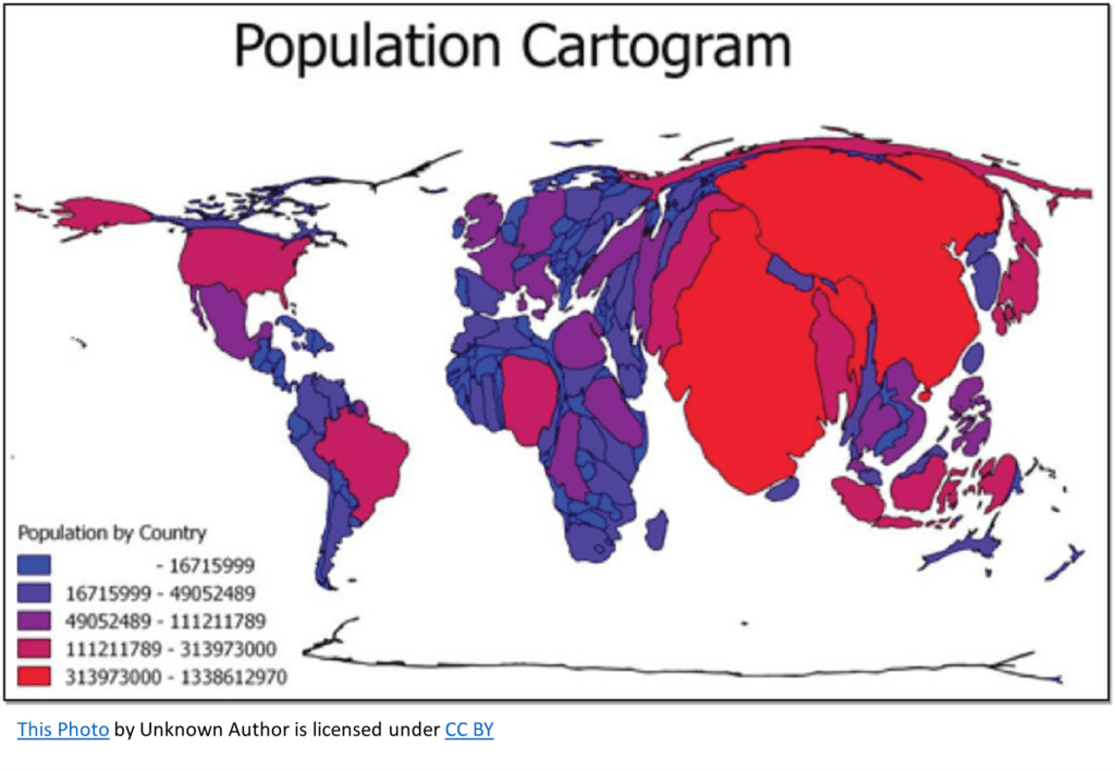
A thematic map that distorts the size of geographic areas so their size reflects a specific variable such as population or GDP.
A thematic map that uses shading or coloring within predefined areas to represent the intensity of a variable.

A map that uses dots to show the presence or frequency of a phenomenon, with each dot representing a specific quantity.
A map that uses continuous lines connecting points of equal value to show patterns in data such as elevation or temperature.

A map that uses symbols of different sizes to represent the magnitude of a variable at specific locations.

Market Area (Hinterland)
The area surrounding a settlement or service, from which people are attracted to use the place's goods and services.
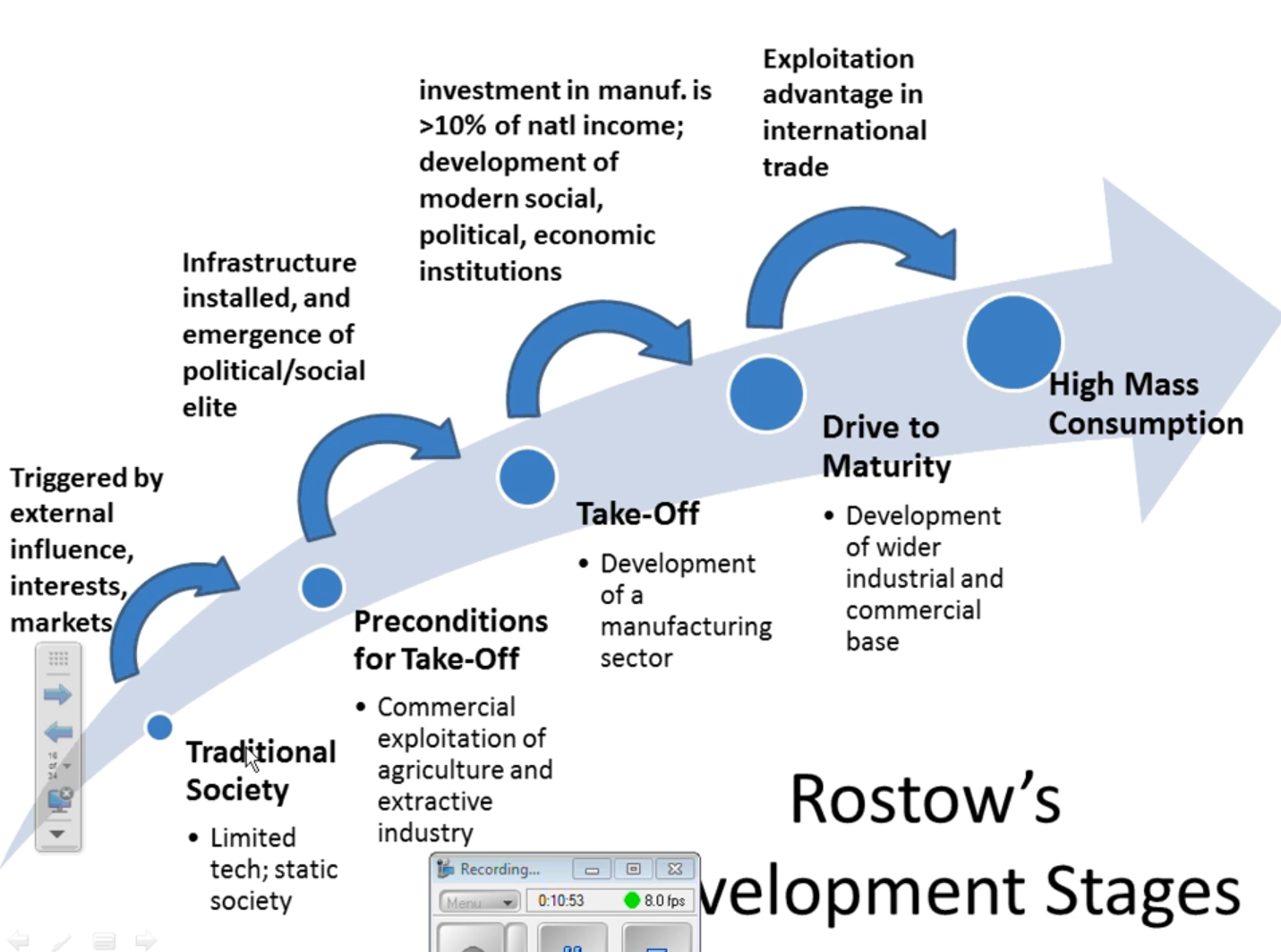
A five‑stage theory of economic development proposing that all countries progress from traditional, agriculture‑based economies to modern, high‑mass‑consumption economies through stages of investment, industrialization, and technological growth.