Unit 1 and people
1/97
Earn XP
Description and Tags
AP human
Name | Mastery | Learn | Test | Matching | Spaced | Call with Kai |
|---|
No analytics yet
Send a link to your students to track their progress
98 Terms
What is globalization
A set of processes that are increasing interactions, deepening relationships, and accelerating interdependence across national borders. Began as an economic movement rooted in free trade but has expanded to all areas of society.
What is scale?
What happens at a local scale will happen at a regional national or global scale
Tobler’s first law of geography
Everything is related to everything else, but near things are more related to each other
Quantitative data
,ensures expressed in numbers (quantity) ex: census data
Qualitative data
Yep of data collected (ex: income range, religion, language) quality
Medical geography
Mapping distribution of a disease is the first step of finding the cause
Dr. John snow did what
He a noted anesthesiologist in london, mapped cases of cholera in 1854 and found a link to contaminated water
Where would we find chlora
In places lacking infrastructure
Immanuel kant
We need disciplines focused on not only the particular phenomena but also the perspectives of time and space.
How many geographical concepts are there
8
What are the major concepts of geography
Location, human-environment interactions, region, place, movement, cultural landscape, scale, and context
Location
Highlights how the geographical position of people and things of earths surface affects what happens and why
Absolute location
Does not change, latitude and longitude
Relative location
Location compared to another thing, may shift
Human-environment interactions
A spatial perspective invites consideration between the relationship of humans and the physical world
Why of where
Where is it and why is it there
Region
Features of the earths surface
Place
Place is a unique location
Toponym
Name of a place
Movement
Movement refers to the mobility of people, goods, and ideas across the surface of the planet
Cultural landscape
The human imprint on the physical or natural environment
Carl sauer
Made cultural landscape
Sequent occupance
Refers to the sequential imprints of occupants, whose impacts are layered one on top of the other, each layer having some impact on the last
Cartography
The art and science of making maps
Reference maps
Shows locations and places and geographic features
Thematic maps
Tells stories, typically showing the degree of some attribute or the movement of a geographic phenomenon
Why do geographers use reference maps
They focus on accuracy in showing absolute locations of places
Topographic maps
They show only the natural/physical features, nothing in the cultural landscape
Global positioning system
Allows us to locate things on the surface of earth with accuracy
GPS
Global Positioning System
What do thematic maps do
Tell stories showing the degree of some attribute or the movement of a geographic phenomenon
Map projections
When transferring 3d to 2d always distortion
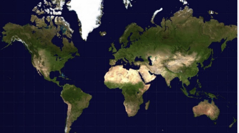
Mercator
Oldest, distortion at poles, used for navigation
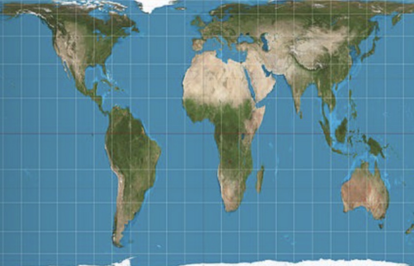
Robinson
Symmetrical, eye pleasing
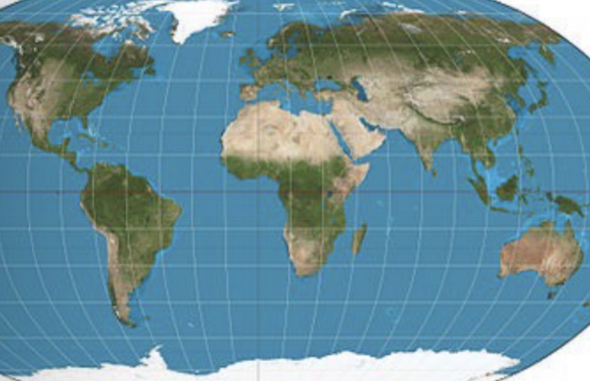
Peters
Most correct for placement, appears elongated
What map?
Mercador
What map?
Robinson
What map?
Peters
Plantar
View from poles, can show shortest distance over poles
Azimuthal
Maps are often polar, everything on the map is equidistant from the center
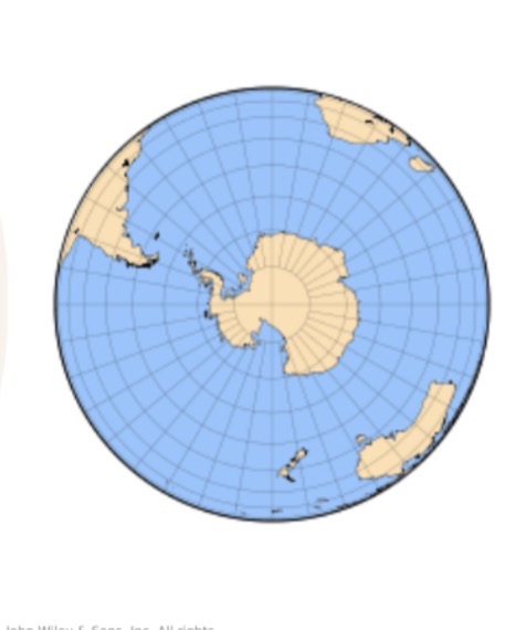
What map?
Plantar
Map scale
The ratio of distance of a map compared to the distance on earths surface (ex: 10,000: 1)
Large scale maps
Shadow small area
Small scale maps
Show large area
Choropleth maps/ generalized maps
Thematic maps that help us see trends
Isoline or isotherm maps
Connect points of equal value on a map (often used in weather but lines for elevation too)
Dot maps
Dots
Symbol map (proportional symbol)
Show different symbols
Cartogram
places increase or decrease in size depending on amount
Map limitations
Omits other info, distortion, scale
Remote sensing
Tech to see the world remotely
GIS
Geographic information system
Geographic information system
Computer hardware and software combined to show analyze and represent geographic data (layers)
What are the two meanings of scale in geography
Distance on a map compared to earth, spatial extent of something and level of analysis
Mal scale
Distance on a map compared to distance on earths surface affects (10,000:1)
Operational scale
Spatial extent of something and level on analysis (local, regional, national, global)
Formal region
A shared cultural or physical trait (ex: French speaking region of Europe)
Functional region
Particular set of interrelated activities or interactions that occur within in (ex: Chicago and its hinterland)
Hinterland
The rural or urban area tied to a city
Perceptual or vernacular region
Intellectual constructs designed to help us understand the nature and distribution of phenomena in human geography (ex: west of US)
Culture
All encompassing term for whole tangible lifestyle and beliefs
Culture complex
More than one culture may exhibit a particular culture trait, but each consists of a discrete combination of traits.
Cultural hearth
An origin area where cultural traits develop and from which cultural traits diffuse
What is it called when a cultural trait develops in more than one hearth without being influenced by its development elsewhere
Independent invention
Expansion diffusion
When an idea develops from a hearth and remains strong there while spreading outward
Contagious diffusion
A form of expansion diffusion where all adjacent individuals and places are affected- usually person to person contact
Hierarchical diffusion
A pattern which the main channel of diffusion is some segment of those who are susceptible to what is being diffused (ex: high fashion)
Reverse hierarchical diffusion
Not as common, the spread of a tree from the bottom to the top
Stimulus diffusion
When an idea meets a barrier and adjusts to it to continue diffusing (ex: India no meat and McDonald’s)
Relocation diffusion
Someone moves and spreads something to where they moved (usually through migration)
Spatial interaction
Distance more less accessible
Time-space compression
Technology changes interaction to more than just distance, but interconnectivness
Environmental determinism
The idea that individual and collective human behavior is fundamentally affected by, or controlled by the physical enviorment.
Environmental possiblism
Environment may limit a range of choices to a culture, hit technology and societies may change that.
Carrying capacity
The amount of people a space may carry
The hearths of agricultural and urban revolutions and major religions
North a,Erica, southwest asia, Southeast Asia, and east Asia
Cultural ecology
Concerned with culture as a system of adaptation
Political ecology
Fundamentally concerned with the environmental consequences of dominant political arrangements and assumptions
Who created mercador map
Gerardus Mercator
Who created the galls-peter map
James Gall and Arno peters
Who created the Robinson projection map
Arthur Robinson
Who created the winkel triple map
Oswald winkel
Malthusian theory
Population grows exponentially and food supply grows arithmeticly
Positive check
Preventive (birth control)
Negative check
Responses to overpopulation (starvation)
Von thügen
Formulated a model explaining and predicting rural land use, specifically where and why different agricultural activities would take place around a cities marketplace
Walter christaller
Central place theory (hexagons)
Hoyt
Hoyt’s sector model or transport model
Burgess
Burgess concentric zone
Harris and ullman
Multiple nuclei model
Chauncy harris
Galactic city model
Larry ford and Ernest griffin
Latin American city model
T.G mcgee
Southeast Asian model
H. De blij
African city model
Alfred Weber
Least cost theory
Rostow
5 stages of economic development we can all become core countries
Immanuel Wallerstein
World systems theory- Core, periphery, semi periphery