METEREOLOGY
1/45
Earn XP
Name | Mastery | Learn | Test | Matching | Spaced | Call with Kai |
|---|
No analytics yet
Send a link to your students to track their progress
46 Terms
With an elevation of 500 feet ASL and a surface temperature of 15°C. The expected temperature at 6 500 feet ASL would be
3°C
6 500 ft - 500 ft = 6 000 ft altitude change
6 x 1.98°C = 11.88°C
15°C - 11.88°C = 3.12°C
What defines the start of the Tropopause?
Sudden change in lapse rate.
Most weather is prevented from rising through the atmospheric layers by the
Tropopause
What percentage of Earth's atmosphere is composed of water vapour?
Less than 1%
The expected temperature at 3 000 feet ASL in standard atmospheric conditions would be
9°C.
15°C at sea level - (1.98°C / 1 000 ft x 3 000 ft) = 9.06°C
The ozone layer is located in the
Stratosphere.
While at FL140 the OAT is -12°C. Under standard atmospheric conditions the expected temperature at FL110 would be
-7°C.
Standard temp at 11 000 feet
11 x 1.98 = 21.78
15 - 21.78 = -6.78 (-7)
The ICAO standard atmosphere temperature at 9,500 feet is closest to
-4 C
During cruise at FL200 the OAT is -35°C. The air mass therefore has an average temperature which is
10°C colder than ISA.
Standard temperature is 15°C at sea level.
Therefore with a lapse rate of approx 2°C /1 000 feet
20 x 2° = 40°
15° - 40° = -25°
Standard temp at FL200 would be -25°
According to the properties of standard atmosphere a station registering 28.00 in Hg at 2 000 feet elevation would report an altimeter setting of
30.00 in Hg.
1 in Hg = 1 000 feet
2 000 / 1 000 = 2 in Hg
28 + 2 = 30 in Hg
Anticyclonic pressure systems in the Northern hemisphere represent
rising air that is rotating clockwise and flowing outward from the center.
Cyclonic pressure systems in the Southern Hemisphere represent
rising air that is rotating clockwise and flowing inwards towards the center.
Which weather map symbol represents a high pressure ridge?
B
The indicated altitude is 8 500 feet with an altimeter setting of 29.42 in Hg. The pressure altitude would be
9 000 feet.
29.92 in Hg - 29.42 in Hg = 0.5 x 1 000 = 500 feet + 8 500 feet = 9 000 feet
Altimeters that are in error by more than . . . . . feet when given a correct altimeter setting must be re-calibrated.
50
After a cold front has moved in the colder air causes the air pressure to increase resulting in a slightly higher altimeter setting.
TRUE or FALSE?
True, altitude corrections should be made to obstacle clearance altitudes when temperature is 0°C or below.
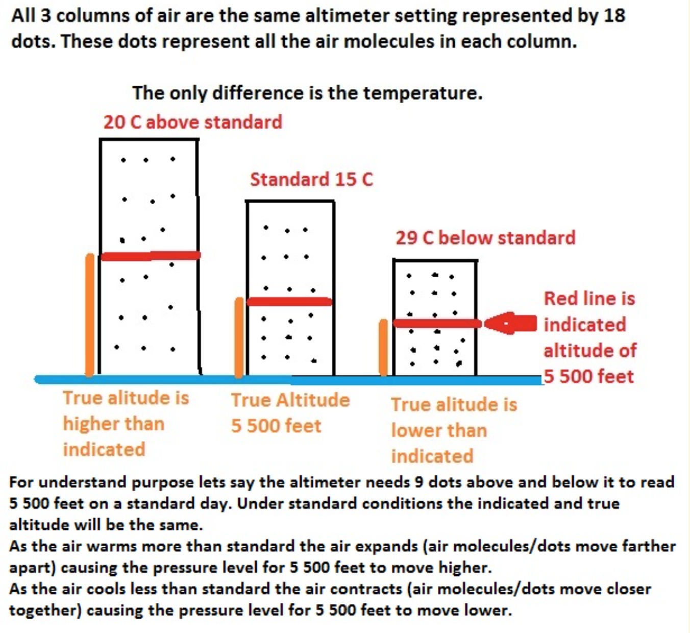
The station pressure, think of as a column of air that is an imaginary rectangle section of the atmosphere that goes form the surface to the edge of the atmosphere. How many air molecules in that rectangle is the atmospheric pressure. The rectangle does not change its size, it is just marking off a portion of air to take a sample to get what the pressure is. As the air warms and cools the amount of air molecules in the rectangle changes giving different pressures. Cold air, as the atmosphere contracts, means there will be more molecules in the air sample so higher pressure. Warmer air causes less air molecules to be in the sample so lower pressure. So the altimeter setting will be changing.
The other thing that happens. In cold air because of the contraction of the atmosphere, the pressure level drops. So for the altitude the aircraft is flying, the pressure level to show the indicated altitude is lower. Once below zero it starts to become a hazard so altitude corrections need to be applied. You have probably seen this when doing circuits in the summer compared to winter. Same indicated altitude but closer to the surface in the winter.
Which condition would cause the altimeter to indicate a lower altitude than that actually flown?
Air temperature higher than standard.
Flying over mountains with a temperature of 24ºC and the altimeter setting of 30.22 in Hg received from a nearby airfield. The terrain below the aircraft rises to 4 000 feet ASL, the true altitude when reaching 6 000 feet ASL will be
6 145 feet.
Pressure Altitude = 5 700 feet
Temperature is 24ºC
The terrain (indicated altitude 6 000 feet - terrain 4 000 feet)
2 x 4 (feet/1 000) = 8
8 x +21 (degrees above standard) = 168
2 000 + 168 = 2 168 feet AGL + 4 000 feet elev = true altitude of 6 168 feet ASL
Do not correct the elevation for non-standard conditions.
An aircraft takes off from Doha, field elevation 30 feet ASL, with the altimeter setting of 30.12 in Hg set on the altimeter. The aircraft then lands at Al Ain, field elevation 500 feet ASL, but without re-setting the altimeter sub-scale. If the altimeter setting at Al Ain at the time of landing is 29.98 in Hg the aircraft's altimeter read on touch-down
640 feet
The difference between 30.12 in Hg and 29.98 in Hg results in a 140 feet difference.
Since the reference is still set to the higher air pressure, lower altitude, this difference needs to be added to the elevation.
Flying at FL220 in an air mass which is 15°C colder than ISA with the local altimeter setting of 29.02 in Hg. What would be the true height over terrain that is at 7 000 feet?
13 200 feet
Because it is stated as FL220 that means a pressure altitude of 22 000 feet. Altimeter is set to 29.92 in Hg.
29.92 - 29.02 = 0.9 x 1 000 = 900 feet
Because the Pressure Level 29.02 is at a higher altitude than the Pressure Level 29.92, we have to subtract the 900 feet from PA to get Indicated Altitude (turning subscale down).
22 000 - 900 = 21 100 feet
The altimeter set to the current altimeter setting would indicate 21 100 feet.
To find out standard temperature at 22 000 feet calculate
15°C - (22 x 2°C) = -29°C
Actual outside temperature is 15°C colder than standard, therefore -29 - 15 = -44°C
Read True height AGL on outer scale = 13 200 feet
If were asked 13 200 + 7 000 Elevation = 20 200 feet ASL (this is the true altitude)
NOTE:
When an aircraft is operating in the standard pressure region with standard pressure set on the altimeter subscale, the term “flight level” is used in lieu of “altitude” to express its height. Flight level is always expressed in hundreds of feet. For example FL 250 represents an altimeter indication of 25 000 feet; FL 50, an indication of 5 000 feet.
During a flight over the sea at FL135 the true altitude is 13 500 feet ASL with a local altimeter setting of 30.08 in Hg. What is known about the air mass in which the aircraft is flying?
The air mass is colder than ISA.
FL135 implies that the altimeter setting is 29.92 in Hg. The pressure altitude is 13 500 feet.
Local altimeter setting is 30.08 in Hg
From above information we can calculate the indicated altitude.
29.92 - 30.08 = - 0.16 x 1 000 = -160 feet Working backwards to get indicated not PA so add
13 500 feet + 160 = 13 660 feet indicated
Since the true altitude is lower, the indicated is higher, the temperature must be below or colder than ISA.
The term flight level (FL) is used when the altimeter setting is 29.92 in Hg. Flight levels are used in high level airspace at 18 000 feet ASL and above, and in Northern Domestic Airspace from the surface up when in cruise.
On the E6B if you line up the true altitude on the outside scale with the indicated/calibrated altitude on the middle scale you will see that in the altitude calculations window that PA of 13 500 lines up near to -12 C, standard temp at 13 500 feet (13.5 x 2/1000 = 27 from 15 = -12). Now if you apply the altimeter setting to the indicated/calibrated. Higher setting means higher altitude shown, so 13 660 feet. And you align that indicated/calibrated altitude to the true 13 500 feet on the outside scale. You will notice that the temperature is colder than standard. Not by much.
An aerodrome at 984 feet ASL has an altimeter setting of 30.54 in Hg at standard temperature. If the temperature dropped 12.5°C the station pressure most likely would be
less than 30.54 in Hg.
Station pressure is the pressure for that elevation (elevation does not change). When temperature decreases the pressure levels change their spacing, move closer together (air is contracting). Since the pressure level height drops but elevation stays constant that means that the elevation is now in a lower pressure.
The altimeter shows pressure level and indicates it by height above sea level. When doing circuits a pilots flies the indicated altitude for the circuit height. In the winter the circuit height AGL is a lot lower even though the altimeter is still indicating circuit height. The colder air has brought the pressure level down, which the aircraft is flying, but the elevation has not changed so the aircraft is now closer to the surface. If the pilot were to climb to the same height AGL as in the summer the altitude on the altimeter would read higher than circuit height, because the pressure dropped.
An aircraft is flying around the Alps at the same level as the summit on a hot day. The altimeter would indicate
a lower altitude than the summit.
This is due to the expansion of the pressure levels on a hot day. If the day were very cold the opposite would occur and the same pressure level would be found lower down - this is why cold temperature corrections become important when considering obstacle clearance.
15 781 feet is the highest, Mont Blanc, in the Alps. This is the true altitude.
On a warm day the atmosphere expands and the pressure level for 15 781 feet rises. So if the altimeter reads 15 781 on a warm day the aeroplane would be higher than Mont Blanc's 15 781 feet true height.
So if the aeroplane is flying at the true height of 15 781 feet on a warm day the altimeter would read less than 15 781 feet.
The condition that pressure altitude is equal to true altitude is when
standard atmospheric conditions exist.
Altimeter are designed to read true altitude at standard conditions, 29.92 in Hg at 15°C the altitude will be 0. We can set the current pressure but there is no option to enter the current temperature. Hence we need to use our E6B to calculate the True altitude. When using E6B we would still use pressure altitude to calculate the True altitude.
A common mistake is thinking the temperature is 15 C to be standard, that is sea level's standard. Standard condition means that the temperature is standard for the altitude while the altimeter is set to 29.92 in Hg.
The standard temperature at 10 000 feet is
-5°C.
Altitude / 1 000 x 1.98°C - Standard Temp at Sea Level 15°C
10 000 / 1000 x 1.98°C - 15°C = - 4.8°C
En route at FL290 with the altimeter set correctly but not reset to the local altimeter setting of 30.57 in Hg during the descent. If the field elevation is 650 feet ASL and the altimeter is functioning properly the approximate indication upon landing is
0 feet.
When flying at FL290 you are required to set your altimeter(s) to 29.92 in Hg because you will be flying in the standard pressure region. If you fail to reset your altimeter(s) at the correct time you will not get the correct indicated altitude on landing. An easy way to remember this is if you fail to reset and the correct setting is higher then your current setting your indicated altitude will be low and if the correct setting is lower then your current setting your indicated altitude will be high. In this case the difference between the two altimeter settings is 0.65 in Hg (30.57 - 29.92) or 650 feet. Because the correct setting is higher that means that you will get an indicated altitude of 650 feet low or 0 feet (650 feet field elevation - 650 feet)
En route at FL290 and the altimeter is set correctly but you fail to reset it to the local altimeter setting of 30.26 in Hg during the descent. If the field elevation is 134 feet and the altimeter is functioning properly it would indicate after landing
206 feet below MSL.
Yes, the altimeter can read below sea level. There are pictures online. Landing with the altimeter set to 29.92 (we know this because altitude is given as a flight level), which is too low of setting. Which means the altimeter is reading low by 340 feet. Which in this case puts the altimeter reading below sea level by 206 feet on landing.
If the air temperature is 8°C at an elevation of 1 350 feet ASL and the standard lapse rate exists. The freezing level will be approximately at
5 390 feet MSL.
Given the standard lapse rate of 1.98°C per 1 000 feet, it needs (8 / 1.98 =) 4 040 feet to cool down to 0° from the current altitude
1 350 + 4 040 = 5 390 feet
Which condition would cause the altimeter to indicate a lower altitude than actually being flown?
Air temperature warmer than standard.
On a warmer than standard day your true altitude will be higher than the indicated altitude. This will cause the altimeter to show lower than the altitude actually flown. Do not confuse this with the aircraft being lower (as it would in cool air). It is only indicating lower than it actually is (a safe thing). Remember the saying "from warm to cold you're being bold". This time we are going from cold to warm meaning the aircraft is not getting closer to the ground at the same pressure level.
While flying at FL250, ATC gives an altimeter setting of 28.92 in Hg in your area, the pressure altitude the aircraft is flying at is
25 000 feet.
At flight level 250 you are flying in the standard pressure region which means the altimeter is set to 29.92 in Hg. The term (FL) Flight Level indicates that you are flying the Pressure Altitude of 25 000 feet, regardless of the current altimeter setting.
A condition that is present when a local parcel of air is stable is
that the parcel of air resists convection.
Stable air is associated with an inversion, thus heating of the stable air mass does not result in convection (vertical movement), until heated above the temperature of the inversion - at this point the air mass becomes unstable.
A common location for an inversion is
in the Stratosphere.
Tropopause is an isothermal layer, temperature remains the same with an increase in height. The change in lapse rate (decrease in temp) to isothermal (constant temp) is how the tropopause is found.
Wake turbulence would create colder air on top and warmer air on the bottom, the rising air would expand and cool and the subsiding are would be compressed and warmed.
Cumulus cloud base forms when the temperature cools to the dew point as the air rises, convection, and cools.
The incoming . . . . . radiation from the sun's rays are re-radiated into the atmosphere as infrared radiation which has a . . . . . wavelength than the incoming solar radiation.
shortwave, longer
Not a means of cooling the atmosphere is
Convection.
Adiabatic refers to a parcel of air that is not affected (in temperature or moisture) by the surrounding air. So as a parcel rises or falls the change in temperature is only caused by expanding (cooling) or contracting (warming).
Radiation (ground warming or cooling air) and advection (horizontal movement of air over warmer or cooler ground) both can warm and cool the atmosphere.
Where as Convection is rising air. As air rises it will expand and cool but it will still be warmer than the surrounding air. Which means it will be adding heat to the higher levels of the atmosphere, not cooling it.
The dry unsaturated adiabatic lapse rate is
3°C per 1 000 feet.
Subsidence is
sinking air causing an increase in temperature and a decrease of relative humidity.
The Sun's visible layers from outer to inner are the
Corona, Chromosphere and Photosphere.
The Sun's energy output operates on a . . . . . year cycle.
11
The Earth's axis is tilted at an angle of . . . . . with respect to the orbital motion.
23.5°
When looking at Earth from the top of the north Pole, it rotates
counterclockwise
The time of year when day or night is the longest is the
Solstice, occurring approximately June 21st and December 20th.
The light spread phenomena refers to
the Sun's rays hitting Earth at an angle instead of perpendicular.
The time of year when the Sun is directly over the Equator is called
the Equinox.
The time of year that Antarctica experiences 24 hours of daylight is the
December Solstice.
At an airport with an elevation of 500 feet ASL there is two stratus layers overhead. The first layer is between 1 000 to 1 500 feet ASL and the second layer at 2 000 to 2 500 feet ASL. Each layer occupies 3/8 of the sky which would be forecast on a TAF as
SCT005 BKN015.
Two scattered layers of 3/8 on top of each other cover more than half of the sky. Therefore the upper layer acts as a ceiling, when looking down from above the two layers are 5/8 and greater of the ground would be covered by clouds.