Option G: LO4) Building sustainable urban systems for the future
1/17
There's no tags or description
Looks like no tags are added yet.
Name | Mastery | Learn | Test | Matching | Spaced | Call with Kai |
|---|
No analytics yet
Send a link to your students to track their progress
18 Terms
Why do urban centers appear?
- Urban centers were invented in different parts of the world to meet the needs of rural dwellers
- Farmers have to supply food to city dwellers, but back then, agricultural output was small, so urban growth was restricted
- As farming productivity improved, larger numbers of urban dwellers could be supported and cities could grow
- This trend accelerated when manufacturing industries developed, further boosting farming productivity
- As cities grew, they brought goods and services that continued to boost farming productivity. Hence, city growth and farming productivity have a symbiotic relationship
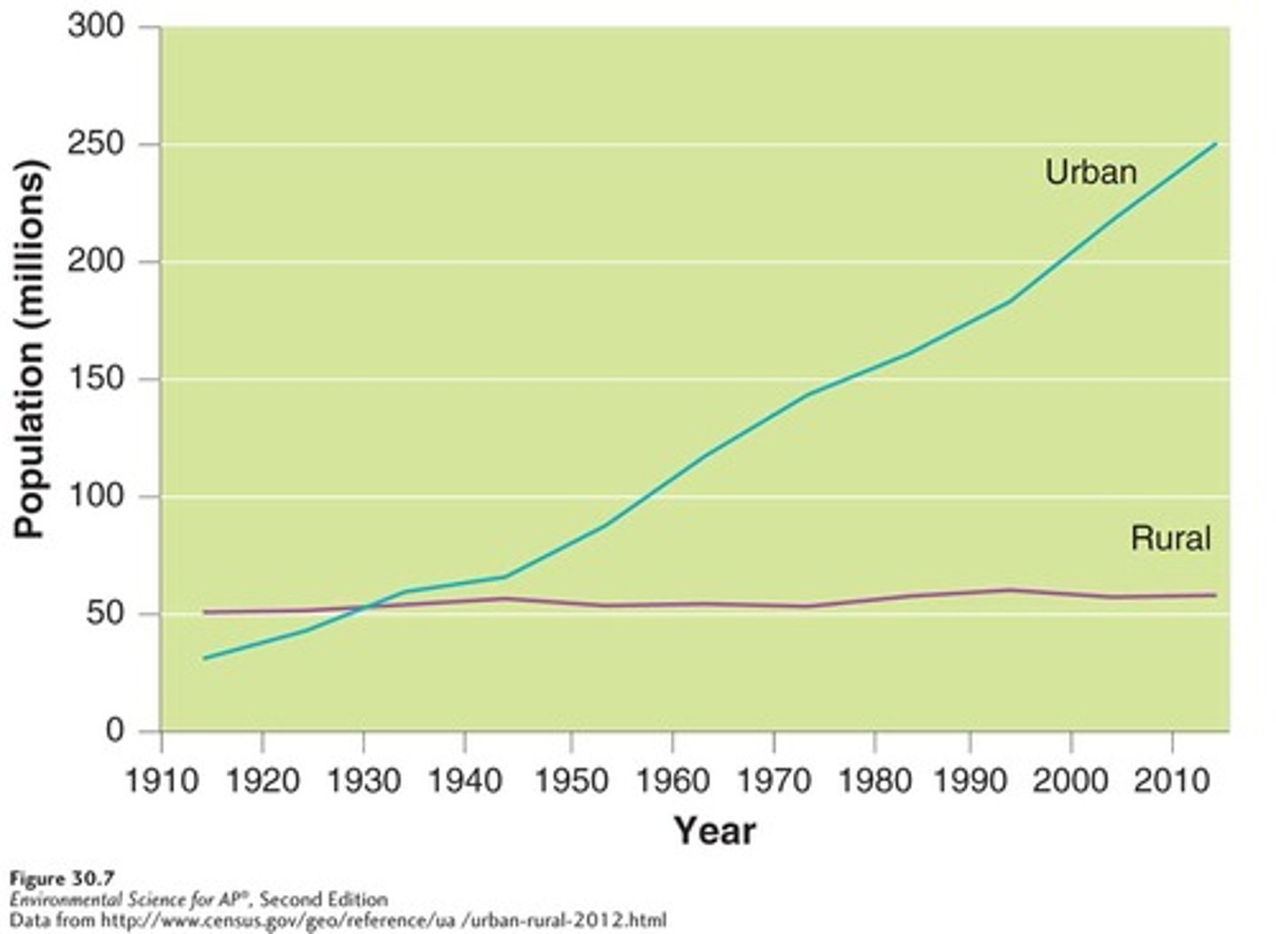
What are the trends in rural and urban population growth over time?
- Originally in the 1500s, there was hardly any urban population, around 800 million people
- It wasn't until 1950 that the world reached the point where 30% of the global population were living in urban areas
- Since then, the pace of urbanisation has accelerated and today around 55% of the world's population will live in urban areas
- You can extrapolate the trend to 66% of people living in urban areas by 2050
- This change means that the percentage of people living in urban areas will have more than doubled during the 100 years from 1950 to 2050
Growth in urban population is linear, but most of this occurs in low-middle-income countries in Asia whereas HICs like North America and Europe are growing at stable rates.
Has urbanisation been uniform over time?
- The trend in urbanisation has not been uniform over time, and will not be up to 2050
- In 1950, only a few countries had more than half their population living in urban areas, and almost all were HICs (America, Europe, Australaisia)
- Since then, 90% of urban growth is expected to occur in China, India and Nigeria, adding 900 million urban dwellers by 2050
- Urban areas will only take up 2% of the world's land surface area
This is because cities can only grow in certain areas that have certain features like coasts for easy access to trading, transport and communications. The amount of money that governments have to support the city growth also impacts the process of urbanisation.
Define the term 'urban resilience' and 'resilient city':
Urban resilience is defined as the capacity of individuals, communities, institutions, businesses and systems within a city to survive, adapt and grow no matter what kinds of chronic stresses and acute shocks they experience.
A resilient city is a city that has the ability to absorb, recover and prepare for future risks.
What are the 2 types of risk events? Give examples of both.
1. Acute shocks - An event that occurs suddenly such as:
- Climatic shocks: major hazardous events such as flooding, extreme heat or storms
- Geopolitical shocks: global political disputes, such as war and terrorism
- Geophysical shocks: natural disasters like earthquakes
- Health shocks: such as disease outbreaks
- Socio-economic shocks: such as financial crises
2. Chronic stresses - Something that gradually affects the ability of a city to function such as:
- Economic problems including inequality
- Socio-economic problems such as crime, lack of healthcare, education or housing
- Infrastructure problems including energy, water, transport and telecommunications
What is the difference between climatic and geopolitical risks?
Climatic risks are dangers posed to a city as a consequence of changes to the local/global climate.
(flooding, heatwaves)
Geopolitical risks are dangers that impact cities as a consequence of events that affect the normal and peaceful course of international relations.
(terrorist attacks, protests, loss of economic power)
Case study: Mexico City Resilient City Strategy
- In 2013, Mexico City was selected to be part of the 100 Resilient Cities initiative, due to their resilience challenges caused by rapid urban expansion and soaring population growth
- Mexico city faces issues regarding inequality, poverty and wealth concentration, given that there is inequality in people's access to services, urban amenities, and quality housing between the eastern and western areas of the city
- Disparities by area exist because water scarcity is reflected in service rotation and poor water quality, particularly in low income areas in the eastern portion of the city
- Loss of 41.4 percent of water in leaks from the drinking water distribution system
Climatic strategy: To ensure equity in water access and water security (solving inequality and intense demand for natural resources + degradation of resources)
1. Integrate the majority of the population who do not have access to clean and stable water sources into the water supply system
2. Install temporary rainwater catchment systems in areas and houses with a scarcity of water
3. Develop blue and green infrastructure to store and reuse water, which will also prevent flooding in vulnerable areas
Effectiveness:
- Through these actions, the supply of water to peri-urban areas was increased, and the difficult to reach areas were helped
- The rainwater catchment systems also guarantees access to basic water service in underserved areas through a flexible system and helps to ensure continuous service in areas with limited access
- Many families now get 40-100% of their annual water needs through this system
- The development of blue and green infrastructure helped to reduce the negative impacts of floods, especially in rainy seasons
- Many citizens do not have a strong awareness of water sustainability and water conservation, and still have unsustainable practices of using water, which makes it hard for the programme to ensure that they can fully utilize what they give them.
Case study: Lagos Resilient City Strategy
- Lagos is the largest metropolitan area and the most urbanised state of Nigeria
- Challenges have been encountered through inadequate infrastructure, primarily caused by high population growth rates and insufficient investment
- There is inadequate public transport, with most residents relying on three wheeled vehicles or yellow minibuses which are cheaper
- Infrastructure that incorporates walking and cycling has yet to be implemented in the transport system which results in many people lacking access to services, and frequent traffic congestion with the average adult spending a weekly 30 hours commuting
Geopolitical Strategy: Develop a stable, multi-modal and integrated transport system
1. Advance the light rail network, bus rapid transit and multimodal interchanges that will allow for more than 1 mode of transport
2. Expand the water transportation with increased private sector participation
3. Develop an E-platform that coordinates public transport services with the generation of real-time data collection on all modes of transportation both informal and formal
Effectiveness:
- By expanding the mass transit operations, the public transport system was used to meet the demands of commuters, and optimised the current usage of the road network. Around 200,000 people now use the BRT to get into the CBD.
- Jobs were created through the various activities required to kick-start rail transport and improve
transport by waterways
- They also created continuous employment opportunities for operators and maintenance crew.
- There are still barriers preventing this from being implemented fully like political interference and financial support
- Some low-income families also still do not have to money to access this public transport
Define the term 'eco-city' and how it functions as a system:
An eco-city is a city built off the principles of living within the means of the environment and reducing the eco-footprint.
A normal city functions as a linear system where there are inputs of food, people and energy, and outputs of waste, air pollution and goods/services.
An eco-city functions as a sustainable/circular system where there are inputs of food, people and renewable energy. In the middle, there is a recycling of organic and inorganic waste and minimized waste and outputs.
Resources are used in ways that meet present human needs while also preserving the environment so that these needs can also be met indefinitely in the future.
Describe 2 differences between a circular city system and a linear city system:
1. A circular system has more processes of recycling, reusing and inputs to reduce waste than linear systems
2. A circular city has smaller inputs of fossil fuels, water and products than a linear system
Define the term 'eco-footprint':
The amount of land and water a population requires to produce the resources it consumes and to absorb its waste under prevailing technology.
Case study: Masdar City
- Masdar City, located in the UAE was planned to be the world's first carbon neutral city
Strategies:
- Personal rapid transport vehicles (PRTs) which take people from where they drop their carbon cars at the edge of the city up to the Masdar institute (zero emissions)
- A high tech wind teflon tower, which propels wind down a funnel to cool the city
- Beam Down project, converts sunlight into electricity in a much more efficient way, heat is captured at the base of the tower so that energy loss is minimized
- It is powered by 88,000 solar panels in a 20 hectare field
- None of the roads are longer than 70m longer, allowing cool breezes to flow along them
- Buildings at the ends of these roads also cause turbulence which, pushing the air upwards and enhancing circulation
Effectiveness:
- Was very successful in reducing carbon emissions by making use of renewable energy sources and innovative technology solutions
- It has a high cost of about 22 billion to build
- It was also hoped that 50,000 people would live there, and 60,000 people workers would commute daily to Masdar city
- However, this would be be at a cost of around $400,000 per resident
- The city is only a fraction of what it was supposed to be back in 2006 when it was announced and is nowhere close to zeroing out its greenhouse gas emissions
- Managers have given up building the city because the goal of zero emissions is too unrealistic with the technology we currently have
- By 2016, only 5% of the 6km^2 of land was built, and only 2000 people were employed there
Case Study: Curitiba, Brazil
When Brazil went through a process agricultureal mechanisation, many farmers lost their jobs and moved to Curitiba, which experienced the fasted urban growth in Brazil. Average annual population growth reached 5.7% per annum.
Strategies:
- A transit system that 60% of their people rely on, with a bus network similar in efficiency to a light-rail system. There are dedicated lanes and buses that are separated by type
- It was decided that the city should be developed for people, not cars leading to the closure of Curitiba's busiest street and converting it into Brazil's first pedestrian plaza
- The green exchange reward scheme for children and adults who can bring their sorted waste to receive school supplies, bus passes and show tickets
Effectiveness:
- Lerner's measures to promote public transport convinced over half the population to give up their personal vehicles and help with the process of 150 miles of bicycle paths being created
- The bus rapid transit system (BRT) satisfies the needs of around 70-80% of the residents resulting in 25% lower carbon emissions than other Brazilian cities
- Having separate bus lanes enables people to travel quickly regardless of traffic conditions on surrounding roads, reducing traffic congestion
- It is estimated that Curitiba's transport system has resulted in a reduction of 40 million car trips per year, meaning they use 30% less fuel per person
- Closing down busy streets improved business for local firms because pedestrians were more relaxed and thus more willing to spend time shopping
- The reward programme for recycling has empowered people with access to transportation and work, so there is decreased dependence on government support, and per capita income is 66% higher than the Brazilian average
- With the green exchange, agricultural products do not go to waste and low-income families get food
- The public buses are still one of the most expensive in Brazil and this is why some people still use cars.
- Buses are also often overcrowded and inadequate on the outer fringes
- There is still poverty that exists, although this has been alleviated through the above methods
Define the term 'smart city' and describe the concept of 'Internet of things':
A smart city is an urban area that uses information and communication technology (ICT) to enhance residents' ability to access and use the city's resources and infrastructure.
The internet of things (IoT) is a brand of ICT involved in smart city design. The interconnection via the computing devices in everyday objects enables them to send and receive data, enabling a two-way information flow.
How can smart technology be used on different levels?
How is the data collected from this smart technology used?
At the personal level, the public can access information like real-time data on transport that improves their efficiency. At the administrative level, smart city technology is embedded in government systems, allowing urban planners to address problems like traffic congestion and to assist with long-term infrastructure development.
Data is collected from IoT devices that have been installed for monitoring purposes. It is also gathered from the wider internet and social media, where residents exchange their problems.
Describe the features of smart cities:
What is future growth of smart cities?
Have the integration of information, communication and technology, often through the use of IoT, across more than 3 functional areas of a city.
These functional areas include transport, energy and sustainability, physical infrastructure, safety and security. It often involves adding intelligence onto existing infrastructure rather than building from scratch.
By 2025, there will be at least 88 smart cities around the world with Europe-Middle-East-Africa having the largest number. The no. of smart cities is expected to quadruple.
What are the advantages and challenges of a smart city?
Advantages:
- They are a response to an increasingly urbanized world dealing with scarce resources and improves energy efficiency
- By providing appropriate technologies and solutions, smart cities can deal with a variety of issues like congestion and energy waste, as well as allocate stressed resources more efficiently, and improve quality of life
- Smart cities can also lessen the effects of growing urbanization like a strained energy provision or urban road network
- Data can help administrators and planners decide which services can be obtained more cheaply, and is less wasteful of resources
Challenges:
- You cannot just ask people to leave town while you retrofit a city and implement a solution, then ask them to come back
- It is hard to implement a smart city strategy in an existing urban area
Case study: Songdo, Korea
- Songdo was a planned city built from scratch on 1500 acres of reclaimed land in the Yellow sea
Strategies:
- Underground tubes carry trash straight to a central waste facility, and buildings are sensor equipped
- Use of buses, subways and bikes will means less use of cars
- 40% of the city's land is dedicated to green space
- It has an aerotropolis, which means that the airport is built into the urban center instead of having it far outside of the city. This means shorter trips to and fro from the airport and reduced emissions
- Every device, component and service is linked to an informational network through wireless computing technology, allowing for greater coordination
Effectiveness:
- There is no need for garbage trucks because the trash is sucked through underground pipes and goes straight to treatment facilities
- They have achieved LEED certification which is the highest energy consumption and waste standards possible
- There are already people living and going to school there
- Everything from the lights and temperature in the apartments can be controlled by the phone which adds convenience into daily lives
- The population only sits at 130,000, which is less than the developer's original target of 300,000
- The city struggles to attracts Korean businesses because the government refuses to give tax incentives for relocation
- Hard to get a sense of vibrant community because of the lack of neighbourhood interaction, and everything is controlled by the phone