1 EQ3 - Glacio-fluvial and Periglacial landforms
0.0(0)
Studied by 0 people Call Kai
 Learn
Learn Practice Test
 Spaced Repetition
 Match
Match Flashcards
 Knowt Play
Card Sorting
1/19

Earn XP
Description and Tags
Last updated 11:46 AM on 5/10/23
Name | Mastery | Learn | Test | Matching | Spaced | Call with Kai | Chat |
|---|
No analytics yet
Send a link to your students to track their progress
20 Terms
1
New cards
What qualities does glacio-fluvial have?
* Smaller than glacial sediment as meltwater streams have less energy than glaciers
* Smooth and rounded
* Sorted
* Stratified
* Smooth and rounded
* Sorted
* Stratified
2
New cards
What is the difference between stratified and sorted sediment?
Stratified: Vertical sorting
Sorting: Horizontal sorting - largest material higher up the valley than finer material
Sorting: Horizontal sorting - largest material higher up the valley than finer material
3
New cards
What are the glacio-fluvial landforms?
* Kames
* Eskers
* Outwash plains
* Eskers
* Outwash plains
4
New cards
What is a kame and what are the two types?
* A kame is a hill composed of stratified sand and gravel laid down by glacial meltwater
* There are two types of kame:
* Deltakames
* Kameterraces
* There are two types of kame:
* Deltakames
* Kameterraces
5
New cards
\
How are delta kames formed?
How are delta kames formed?
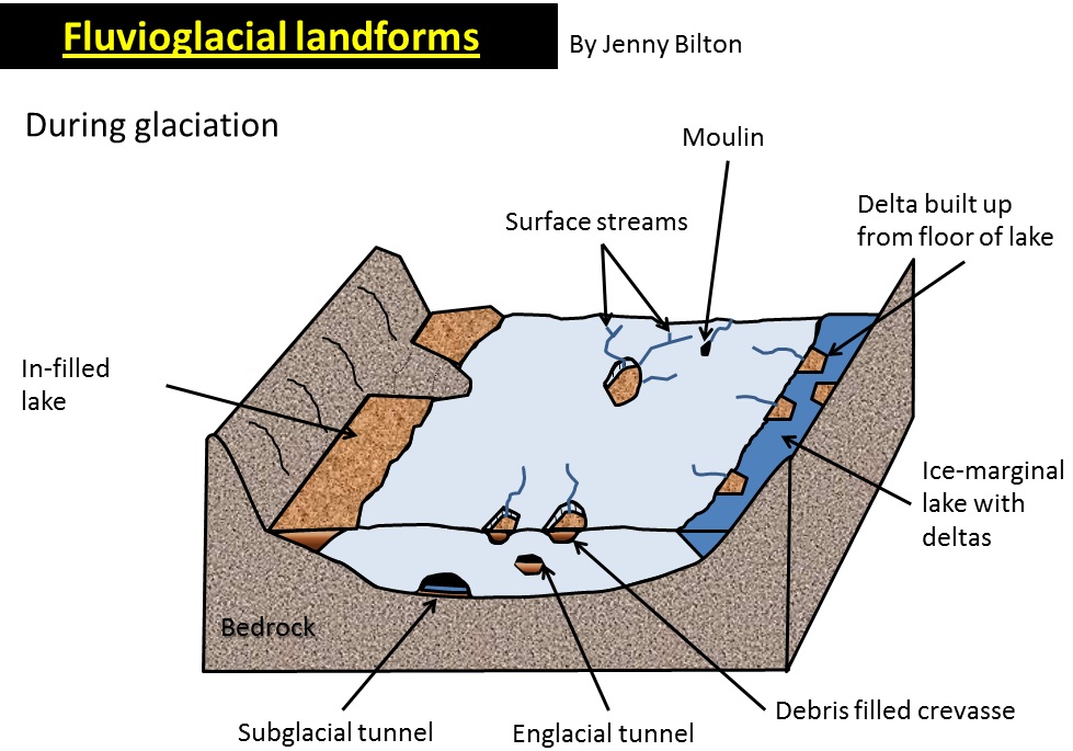
**Delta kames**
* Form in different ways
* Some are formed by en−glacialstreams emerging at the snout of the glacier which lose energy at the base of the glacier and deposit their load
* Others are the result of supraglacial (above glacier) streams depositing their material on entering ice−marginallakes (lake next to glacier)
* Entering the lake causes the stream to lose energy and deposit their load
* Form in different ways
* Some are formed by en−glacialstreams emerging at the snout of the glacier which lose energy at the base of the glacier and deposit their load
* Others are the result of supraglacial (above glacier) streams depositing their material on entering ice−marginallakes (lake next to glacier)
* Entering the lake causes the stream to lose energy and deposit their load
6
New cards
How are kame terraces formed?
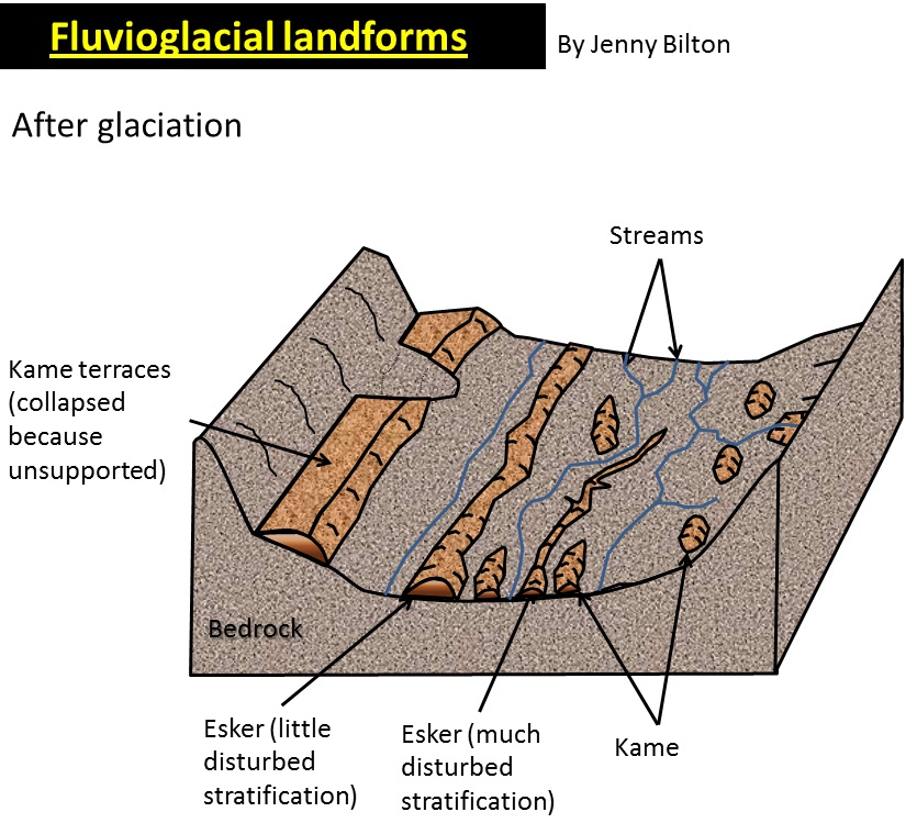
**Kame terraces**
* Ridges of material running along the edge of the valley floor
* Supraglacialstreamsontheedgeoftheglacier carry lateral moraine which is later deposited on the valley floor as the glacier retreats
* The streams form due to the melting of ice warmed in contact with the valley sides as a result of friction
* They can be differentiated from lateral moraines by their rounded and sorted sediment
* Ridges of material running along the edge of the valley floor
* Supraglacialstreamsontheedgeoftheglacier carry lateral moraine which is later deposited on the valley floor as the glacier retreats
* The streams form due to the melting of ice warmed in contact with the valley sides as a result of friction
* They can be differentiated from lateral moraines by their rounded and sorted sediment
7
New cards
Give a located example of each fluvio-glacial landform
* Delta kame: EastLothian, Scotland
* Kame terrace: KingsdaleValley of the Yorkshire Dales - ==2km long==
* Esker: StJohn’sVale, Lake District
* Kame terrace: KingsdaleValley of the Yorkshire Dales - ==2km long==
* Esker: StJohn’sVale, Lake District
8
New cards
What is an esker?
A longsinuousridge composed of stratified sand and gravel laid down by glacial meltwater. Formed at the end of the glacial period. They are rare in the Lake District
9
New cards
Explain how an esker is formed
* Material is deposited in sub-glacial tunnels as the supply of meltwater decreases at the end of the glacial period
* Sub−glacialstreams can carry large amounts of debris under pressure
* Some believe that deposition occurs when the pressure is released and meltwater emerges at the glacial snout
* As the glacier snout retreats, the point of depositions moves backwards
* This explains why some eskers appear beaded - the larger beads represent periods when the retreat slowed
* Sub−glacialstreams can carry large amounts of debris under pressure
* Some believe that deposition occurs when the pressure is released and meltwater emerges at the glacial snout
* As the glacier snout retreats, the point of depositions moves backwards
* This explains why some eskers appear beaded - the larger beads represent periods when the retreat slowed
10
New cards
What is an outwash plain?
A flat expanse of sediment in the pro-glacial area
11
New cards
How is an outwash plain formed?
* As the meltwater streams lose energy as they enter lowland areas they deposit their load
* The largest material is deposited first, closest to the snout of the glacier
* Outwash plains are drained by braided streams
* The sediment is stratified, sorted and smoothed
* The largest material is deposited first, closest to the snout of the glacier
* Outwash plains are drained by braided streams
* The sediment is stratified, sorted and smoothed
12
New cards
What is the definition of permafrost?
Areas with:
* perennially (year round) frozen ground overlain by an active layer
* seasonal temperature variations
* freeze-thaw cycles dominating geomorphic processes
* perennially (year round) frozen ground overlain by an active layer
* seasonal temperature variations
* freeze-thaw cycles dominating geomorphic processes
13
New cards
What are the peri-glacial landforms?
* Patterned Ground
* Pingos
* Open
* Closed
* Ognips
* Pingos
* Open
* Closed
* Ognips
14
New cards
What are the located examples of the periglacial landforms?
* Patterned Ground: Barrow,Alaska
* Open system pingos: Greenland
* Closed system pingos: NorthwestCanada
* Ognip: Llanberis,Wales
* Open system pingos: Greenland
* Closed system pingos: NorthwestCanada
* Ognip: Llanberis,Wales
15
New cards
What is frost-heave?
* A process that occurs below the surface that leads to the vertical sorting of material in the active layer
* Stones within the soil heat up and cool down faster than their surroundings
* They have a lower specific heat capacity
* As temps fall water beneath the stones freezesandexpands, forming icelenses which push the stones upwards to the surface
* As the stones are cooler the water beneath the stone freezes faster than the surrounding water
\
* Ground ice also pushes overlying material upwards forming a domed surface
* During the summer water percolates into the active layer
* During the winter this freezes and expands by around ==10%== and forms a dome
* Stones within the soil heat up and cool down faster than their surroundings
* They have a lower specific heat capacity
* As temps fall water beneath the stones freezesandexpands, forming icelenses which push the stones upwards to the surface
* As the stones are cooler the water beneath the stone freezes faster than the surrounding water
\
* Ground ice also pushes overlying material upwards forming a domed surface
* During the summer water percolates into the active layer
* During the winter this freezes and expands by around ==10%== and forms a dome
16
New cards
How is Patterned Ground formed, and what is it?
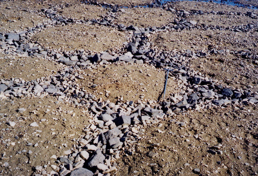
* The stones that reach the surface as a result of frost heave move radially down each domed surface to form a network of stone polygons
* Typically ==1-2m== in diameter
* Typically ==1-2m== in diameter
17
New cards
What is a pingo?
Rounded ice cored hills that grow at rates of a couple of cm per year. They can reach ==90 m== in height.
18
New cards
How are pingos formed and what are the two types?
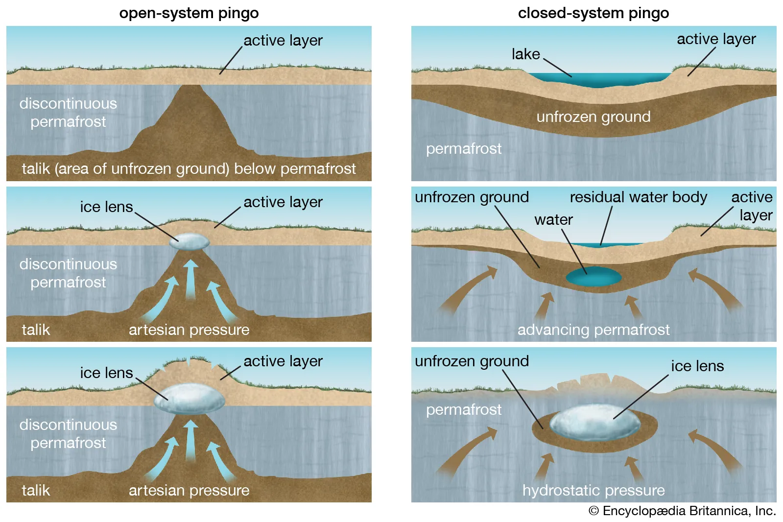
Formed by ground ice which develops during the winter months. The two types are:
* Opensystempingos
* Form in valley bottoms where the water from the surrounding slopes collects under gravity and expands under artesian pressure
* The overlying material is force to dome upwards
* Closesystempingos
* Develop beneath lake beds where the supply of water is from the immediate local area
* The permafrost grows during cold periods and groundwater beneath the lake is trapped by permafrost below and the frozen lake above
* The saturated talik (unfrozen ground) is compressed by the ice around it and is under hydrostatic pressure
* When the talik eventually freezes it forces up the the overlying sediments
* Opensystempingos
* Form in valley bottoms where the water from the surrounding slopes collects under gravity and expands under artesian pressure
* The overlying material is force to dome upwards
* Closesystempingos
* Develop beneath lake beds where the supply of water is from the immediate local area
* The permafrost grows during cold periods and groundwater beneath the lake is trapped by permafrost below and the frozen lake above
* The saturated talik (unfrozen ground) is compressed by the ice around it and is under hydrostatic pressure
* When the talik eventually freezes it forces up the the overlying sediments
19
New cards
How do ognips form?
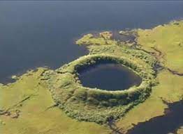
Pingos collapse when temperatures rise and the ice core thaws. When this happens the top of the dome collapses and leaves a rampart surrounding a circular depression called an ognip.
20
New cards
How do periglacial landforms change?
* Pingos form ognips when the temperature rises
* Patterned ground is often colonised by vegetation, making it hard to identify. Mass movement by creep also degrades the landform
* Patterned ground is often colonised by vegetation, making it hard to identify. Mass movement by creep also degrades the landform