Eco Week 1
 Call Kai
 Learn
Learn Practice Test
 Spaced Repetition
 Match
Match Flashcards
 Knowt Play
1/14

There's no tags or description
Looks like no tags are added yet.
Name | Mastery | Learn | Test | Matching | Spaced | Call with Kai | Chat |
|---|
No analytics yet
Send a link to your students to track their progress
15 Terms
Fly species distribution and abundances example:
Beetles can only reproduce during the warm period and are dormant during the cold. Beetles need snow to survive because during droughts, beetles go higher in elevation and snow buffers the soil from fluctuation in the air temperature. As temp gets warmer, the snow melts and soil loses its insulation. The environment changes along gradients, so lower on the mountain its warm but dry.
Droughts increase cold stress on beetles. Dryer years have colder soil in any elevation than for snowy years where the soil is protected.
At low elevations, flies control beetle populations and they’re most abundant at low elevations, determining the beetle numbers at these elevations. Cold temperature and lack of oxygen determines upper limits of where beetles can live.
What is the study of ecology?
Ecology is the study of interactions of living organisms with their environment. There are organismal, population, community, ecosystem, landscape, and global ecology.
Abiotic and biotic factors and species range limits.
The ecosystem comprises all the biotic (living) and abiotic (non-living) components of an area. These factors dictate range limits.
Abiotic factors:
climate and temperature: dictate where an organism can survive
PH, moisture: physical limits on water availability; soil chemistry, or water salinity restrict life
Biotic factors:
competition: rival species can block a species from expanding
predation and prey availability: specialized diets restrict species to the geography of their food source
Mutualism: positive interactions like mutualism can expand or constrain ranges depending on whether partner species are present.
What is traditional ecological knowledge?
Its a Western term used to summarize understandings of different Indigenous peoples regarding natural phenomena, environmental change, interactions among organisms, and human dependences.
What determines where species live?
For terrestrial organisms, temperature and precipitation are the largest abiotic environmental influences on distribution
For aquatic organisms, light and nutrients have the largest impact
Temperature
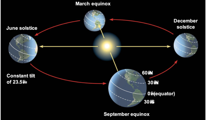
It is cooler at the poles because the incoming light hits at a low angle. Temperature increases at low latitudes because they receive more solar radiation. For latitude, 0 runs across the middle, and it goes up to 90 from both sides (its not negative as you move down from the 0 mark)

Seasons
The Earth’s tilt causes seasons. During winter, the Northern Hemisphere faces away from the Sun while the Southern Hemisphere faces the Sun, so it is winter in the Northern Hemisphere and summer in the Southern. During summer, the Northern Hemisphere faces the Sun, so it’s summer in the Northern Hemisphere and winter in the Southern Hemisphere.
Air circulation
Hadley cell is a large-scale tropical atmospheric circulation pattern where warm, moist air rises near the equator, flows towards the poles at high altitudes, cools and descends into the subtropics, and then returns to the equator.
As the air travels down into the warm tropics, the warm air rises and releases moisture, and is carried up into the mid latitudes. As air drops, it absorbs moisture and carries it into the tropics:
At the equator (0): the air is very warm and humid. It rises, cools, condenses, and there’s heavy tropical rainfall.
Upper troposphere: air cools as it moves away from the equator towards the poles. As air travels higher, it loses most of its remaining moisture via precipitation
Subtropics: temperature has cooled significantly and the cool, dry air sinks towards the surface, suppressing clouds/rainfall and forming deserts.
Surface: as air flows back along the surface of subtropics towards the equator, it warms up. It starts dry and then picks up moisture as it approaches warm tropical waters.

Climatic Zones
Climatic zones are regions of the Earth defined by patterns of temperature and precipitation:
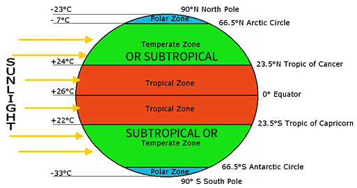
Tropics (0-23.5 degrees): warm, wet, weakly seasonal (wet/dry seasons)
Temperate zone (23.5-60 degrees): highly seasonal, cold winters and warm/hot summers, large landmasses in northern hemisphere (continental)
Polar (60-90): Year-round low temperatures. 24 H dark or light at solstices.
Latitudinal variation in temperature
At low latitudes (near the equator), the Sun’s rays strike the Earth almost at a direct angle, concentrating solar energy and producing consistent temperatures year-round.
At high latitudes, the Sun’s rays hit a slant, so energy is spread over a wider area. Also, at polar regions, there is ice/snow that reflects a high percentage of incoming sunlight back, keeping temperatures very cold.
Tropical areas have very little seasonal temperature change. When you move into the middle and high latitudes (temperate and polar zones), seasonal temperature swings are enhanced.
Average yearly temperature decreases as latitude increases (closer to poles, colder it gets)

Latitudinal variation in precipitation
At equator (0): there’s high precipitation because intense direct sunlight heats the air (they move faster and bounce further apart), causing it to rise. As warm air rises, it cools, condenses, and drops heavy rainfall.
Subtropics (around 30 - deserts): air that rose at the Equator cools and descends. The descending air warms and dries out, preventing cloud formation and making major deserts.
Mid latitudes (around 60 - moderate to high precipitation): warm tropical air
Poles (90 - dry/polar deserts): cold air holds very little moisture and sinks, leading to low precipitation
Environmental and latitudinal gradients
environmental gradients: steady change in an environmental variable through space
latitudinal gradients: steady change in the environment across latitude
Latitudinal gradients are steeper on land and in the Northern Hemisphere because land experiences harsher climatic fluctuations, greater temperature extremes, and lower heat capacity
In Late-Paleocene/Early Eocene, latitudinal temperature gradients were shallow (slow change over space) and tropics extended to 30 degrees. Latitudinal gradients are becoming shallower now that our world is warming.

Elevational gradients and oxygen availability
As elevation increases, oxygen availability declines due to decreased atmospheric pressure which spreads the oxygen molecules further apart.
Temperature at high elevation
Lower pressure → lower temperature, so temperature declines as elevation increases because there’s lower pressure.
Rising air expands and cools because air pressure decreases at high elevation
Windward Leeward side explanation of precipitation
Precipitation increases at high elevation on the windward side of mountains. The leeward side is sheltered from winds. Air gets cooler as it rises, and since it can hold as much water vapor as warm air, moisture condenses and it drops down as rain or snow, making the windward side wet and green. Remaining air descends down the other side, and as air descends, it warms and absorbs moisture, creating a rain shadow on leeward side → creates dry, arid environment because the warm air absorbs moisture.
Rainfall increases going up the windward side of a mountain range. As air cools, water vapor condenses and falls out as rainfall.
Descending air and reduced moisture left in the atmosphere lead to a rain shadow on the side sheltered from the prevailing winds.
