Geography 1000 - Test 4
 Call Kai
 Learn
 Practice Test
 Spaced Repetition
 Match
 Flashcards
 Knowt Play
1/96

Earn XP
Description and Tags
97 Terms
Theory of Plate Tectonics → Founder/Theorist
Alfred Wegner
Theory remains controversial for decades until the concept of seafloor spreading was developed in the 1960s, providing critical evidence for plate movement.
Evidence Supporting Plate Tectonic Theory
Continental drift
Mapping of seafloor and mid-ocean ridges
Magnetic reversals recorded in seafloor spreading
Ocean crust gets older further from seafloor ridges
Continental Drift
Matching coastlines were and early observational clue
Rock, fossils, and ancient environments line up across oceans
Bathymetry
Mapping and analyzing underwater terrain
sonar, satellite, LiDAR, etc.
Seafloor spreading
Seafloor spreading creates new ocean crust; new basaltic crust forms as plates move apart
Magma rises to fill the gap and solidifies as new oceanic crust
New crust is added continuously as older crust moves away from the ridge

Magnetic reversal at the seafloor
Magnetic reversals record seafloor spreading
Earth’s magnetic field leaves a symmetrical pattern in newly formed ocean crust
Cooling basalt locks in the direction of Earth’s magnetic field
The magnetic field has reversed many times through Earth history
Matching magnetic stripes on both sides of a ridge show that new crust forms and moves outward

Oldest vs youngest crust
Younger oceanic crust is located along the mid-ocean ridges
Crust becomes progressively older with distance from the ridge

Earth’s lithosphere is broken into how many plates?
14 main plates
Plates include both oceanic and continental lithosphere
Most geologic activity is clustered near plate boundaries
3 kinds of plate boundaries
Convergent
Divergent
Transform
Types of convergent boundaries
Ocean-ocean
Ocean-continent
Continent-continent
Divergent plate boundaries
Plates move apart and new lithosphere forms between them
Features: ridges, rifts, shallow earthquakes, volcanism

Divergent plate boundary → Ocean ridges
Seafloor spreading creates basaltic oceanic crust
Divergent plate boundary → On Continents
Stretching and thinning can create a rift valley
Transform plate boundaries
Plates slide horizontally past one another
Conserve crust; no major crust is created or destroyed
Shear stress accumulates along faults
Can produce shallow earthquakes

Ocean-continent convergence
dense oceanic lithosphere descends beneath the continental crust that is less dense; subduction
builds continental margins
Trenches, earthquakes, magma generation, mountain building

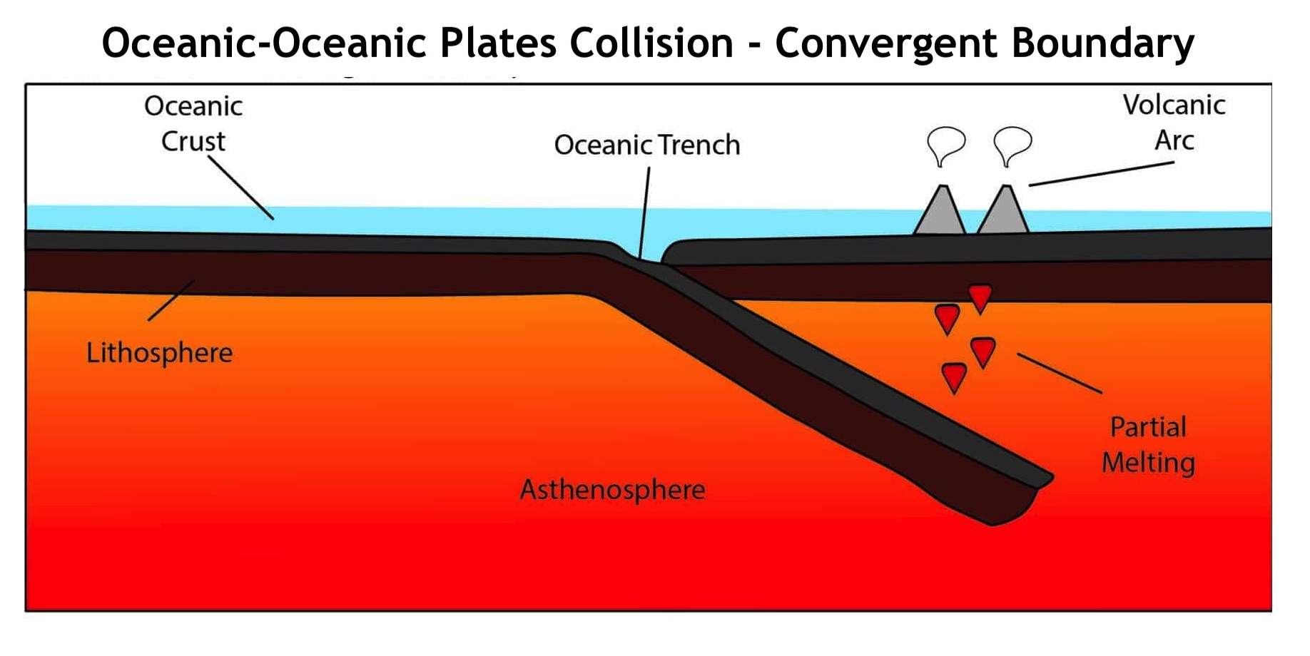
Ocean-ocean convergence
one oceanic plate subducts beneath the other
Builds island arcs
Marked by deep ocean trenches
The magma generated produces a curved chain of volcanic islands
Continent-continent convergence
Continental crust resists subduction and shortens and thickens
Little to no subduction-arc volcanism
Hazards created by each type of plate boundary
Convergent
Subduction
Strong Earthquakes
Volcanic arcs
Ocean lithosphere sinks
Divergent
Rifting/spreading
Shallow earthquakes
Basaltic volcanism
New crust forms
Transform
Plate slide past
Shallow earthquakes
Little volcanism
Crust is neither made nor destroyed
Hot Spots
Areas of persistent volcanic activity within a plate
Localized mantle upwelling
Do not have to sit on a plate boundary to form
Identify the plate-boundary type and expected landform:
Young basaltic seafloor + ridge
Divergent boundary
New ocean crust forms at a mid-ocean ridge
Identify the plate-boundary type and expected landform:
Deep trench + volcanic mountain chain on a continent
Ocean-continent convergence
Subduction builds a trench and continental volcanic arc
Identify the plate-boundary type and expected landform:
Very high folded mountains + thickened continental crust
Continent-continent convergence
Collison shortens and thickens bouyant continental crust
Identify the plate-boundary type and expected landform:
Linear fault zone + horizontal displacement + earthquakes
Transform
Shear produces strike-slip faulting; crust is conserved
Cratons
old, strong pieces of continental lithosphere
Tectonically stable
Where exposed at the surface they form shields
Terrane accretion
Crust fragments added onto the edge of an existing continent
Stress
The force applied to rock
Measured as force per unit-area
Can pull, push or shear rock
Strain
The deformation produced by stress
Response depends on the rock type, temperature, pressure, and stress
3 main stresses
tension
Compression
Shear
Tension
Pulls rock apart and produces faults
Common at divergent boundaries and continental rifts
Compression
Pushes rocks together, producing folds and reverse or thrust faults
Common at convergent plate boundaries
Ductile rocks fold; brittle rocks fracture
Shear
distorts the crust and produces strike-slip faults
Common at transform boundaries
Normal Fault
Caused by tensional stress
Hanging wall moves down

Reverse / thrust fault
caused by compressional stress
Hanging wall moves up

Strike-slip fault
Caused by shear stress
Blocks move laterally

Folding
The ductile response to compression
Rocks bend instead of breaking, layered rocks from folds
Anticline: arch-shaped fold
Syncline: tough-shaped fold
Steps of mountain formation
Add crust → volcanism, igneous intrusions, etc.
Deform crust → compression folds, faults, shortens existing rocks
Thicken + uplift → thicker, more buoyant crust rises to create high relief
Erosion → water and gravity break down mountains
Earthquake
A sudden release of stored elastic energy
When stress exceeds fault resistance, the fault slips abruptly
Energy radiates outward as seismic waves
Elastic rebound
stress accumulates gradually, slip and energy releases are sudden

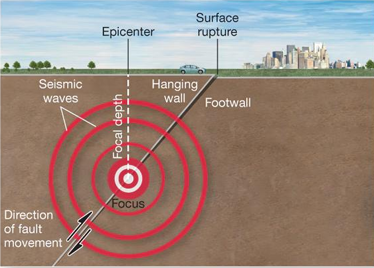
Earthquake focus
Point inside Earth where rupture begins

Earthquake epicenter
Point on the surface directly above the focus
P Waves
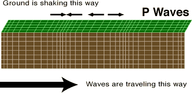
Fastest seismic waves
Arrive first
Compressional "push-pull” motion
Travels through solids, liquids, and gases
S Waves
Slower
Arriver after P waves
Shearing motion perpendicular to travel direction
Travel through solids only

Seismometer
Records ground motion; seismograms turn shaking into a measurable time series
Amplitude records the size of ground motion at the station
Estimate source location and magnitude
Magnitude
One value for the event
Based on physical size of rupture /seismic moment
Does not depend on where you are
Intensity
Varies from place to place
Describes observed shaking and damage
Depends on distance and local conditions
Why can the same magnitude produce very different damage?
Earthquake: magnitude, depth, rupture, direction, distance
Ground conditions: bedrock vs sediment, water saturation, basin effects
Society: building design, density, preparedness, time of day
Earthquake hazards
Ground failure
Surface rupture
Liquefaction
Landslides
Water hazards
Tsunami
Dam / levee failure
Coastal inundation
Built environment
Building collapse
Fires
Infrastructure disruption
Which community is likely to experience the greatest damage, and why?
a. M7.0, shallow, 15 km from a dense city built on water saturated sediment
b. M7.0, shallow, 15 km from a low-density town on competent bedrock
c. M7.0, deep, 120 km from a city with modern seismic construction
d. M6.5 offshore subduction event with strong vertical seafloor displacement
a. likely strongest urban damage. Shallow source + soft saturated sediment + high exposure.
b. lower than A. Same magnitude and distance, but stronger ground and lower exposure
c. typically lower shaking. Greater depth and distance reduce shaking; resilient construction lowers vulnerability
d. special concern. Even with lower magnitude, vertical seafloor displacement can create tsunami hazard
Where do volcanoes erupt?
Divergent boundaries: decompression melting produces basaltic magma
Subduction zones: water from the slab promotes melting above the descending plate
Hotspots: volcanism occurs within plates, away from a boundary
Most volcanoes occur in predictable tectonic settings
Low viscosity
Hotter, basaltic magma
Flows easily
Gas escapes easily
Less explosive
High viscosity
Cooler, silica-rich magma
Slower flow
Gas can become trapped
More explosive
magma traps gas until pressure released violently
Ash columns
Composite volcanoes
Steep, tall, layered cone
Built from lava flow
More viscous magma
Explosive eruptions
Shield Volcanoes
broad, gentle slopes
Built by fluid basaltic lava
Effusive eruptions
Long lava flow that spreads far
Cinder Cones
small, steep sided cone
Built from sediment and cinder
Short-lived eruptions
Formed around a single vent
Pyroclastic flows
hot mixture of gas, ash, and rock that move rapidly
They are dense, fast, extremely hot and leave little time to escape
Volcanic hazards near the vent
Ballistic blocks / bombs
Lava flow
Pyroclastic density currents
Volcanic hazards down valley
debris avalanches and landslides
Lahars
Flood from melted snow / ice
Volcanic hazards downwind
ash fall
air-quality + health impacts
How do we monitor volcanoes?
Seismicity
Fracturing magma can produce earthquake swarms
Deformation
GPS and satellite measurements
Gas+heat
Changes in gas chemistry and thermal output
Caldera
form after large magma systems erupt and collapse
Lava hotspot system
Endogenic landform processes
Endogenic processes are geological events powered by energy originating inside Earth
Tectonic uplift
Volcanism
Crustal deformation
Exogenic landform processes
Originate from external forces acting on the Earth
Weathering
Erosion + transport
Mass movement
Steady state system
Conditions fluctuate around a stable average
Small adjustments are frequent
Dynamic equilibrium
The landscape adjusts while the system remains in balance
A longer-term trend can occur as conditions change
Weathering
The breakdown of rock in place
NO transport required
Erosion
Removal + Transport
Water, ice, wind, gravity
Mass movement
Gravity-driven downslope motion
Rock, debris, or soil
Deposition
Material comes to rest
Sediment accumulates
Physical Weathering
Breaks rock into smaller pieces
Physical breakdown increases surface area for chemical weathering
Does not change mineral composition
Chemical weathering
Dissolves or alters minerals
Weakens rock and creates material that can later be transported
Why do rocks not weather at the same rate?
differences in mineralogy, fractures, exposure and climate
Weak or soluble layers retreat faster
Joints expose more surface area to water and air
Regolith
loose surface material that become sediment and often the parent material for soil
5 controls of rock weathering
Rock + Joints
Climate
Water
Slope Aspect
Vegetation
How does rock composition and structure affect weathering?
Different minerals weather at different rates
Hard/insoluble rock generally persists longer
Joints and fractures increase exposed surface area
More pathways → more water and oxygen for chemical reaction = faster weathering
How does climate affect weathering?
Warm + wet → rapid chemical weathering
Repeated freezing + thawing → frost cracking
Dry climates can favor salt crystal growth
The same rock in different climates will have a different rate of weathering.

How does subsurface water affect weathering?
water enters joints, bedding, planes and pores
Water dissolves minerals and transports dissolved ions
Acid in soil / water can accelerate erosion
Drives both chemical and physical weathering
How does slope orientation affect weathering?
different slopes have different sun exposure, temperature, moisture, snowfall, vegetation, etc.
South-facing slopes = warmer and drier
North-facing slopes = cooler and moister
How does vegetation affect weathering?
Roots reinforce regolith and can reduce erosion
Tree canopies can shield the surface
Roots can pry open existing cracks
Organic acids can lead to chemical weathering.
Plants can stabilize and weather rock at the same time
Examples of physical weathering processes
frost cracking
Salt crystal growth
Root wedging / exfoliation
Examples of chemical weathering processes
dissolution
oxidation
Hydrolysis
Frost cracking
water et]enters cracks; repeated freezing can generate enough stress to detach blocks
Common in cold and high elevation environments
Salt crystal growth
physical weathering process
water evaporates
crystals grow in rock pores
Crystal pressure weakens the rock
Exfoliation / sheeting
physical weathering process
Outer sheets detach
Hydrolysis
Chemical weathering process
Water reacts with silicate minerals and forms clay
Oxidation
Chemical weathering process
Oxygen reacts with iron-bearing minerals
Forms rust-like oxides that weaken the rock
Dissolution
chemical weathering process
Acidic water dissolves minerals, weakening and removing rock
Triggers that can cause a slope to fail
Rain / Snowmelt
Earthquake
Erosion
Volcanic activity
Human activity

Explain this image
Gravity drives slope motion; friction and cohesion resist it
Driving factors
Gravity
Weight of material
Angle of slope
Resisting factors
Friction
Cohesion
Root reinforcement
Relationship between resisting strength/driving stress and slope failure
Stable = resisting strength > driving stress
Failure = driving stress > resisting strength
How do people affect slope stability?
can increase or reduce
Construction changes slope, drainage and vegetation
4 types of slope failure
fall
slide
flow
creep
Falling slope
material detaches and falls through the air
Triggered by weathering, undercutting or shaking
Rapid
Happens at steep/vertical slopes
Translational slide
Movement along a planar surface
Rotational slide
Movement along a curved surface
Debris flow
Triggered by intense rain or rapid snowmelt
extremely fast and far reaching
Creep slope failure
Slow deformation accumulates over years
solifluction
Slow, downslope flow of waterlogged soil over frozen ground or permafrost