ERTH Science Lab Pratical
 Call Kai
 Learn
 Practice Test
 Spaced Repetition
 Match
 Flashcards
 Knowt Play
1/34

There's no tags or description
Looks like no tags are added yet.
35 Terms
density
mass per unit volume,mass of sample / volume of sample (g/mL). lowest density of rocks will "float" the highest in fluid.
oceanic crust
composed of denser rocks, thinner, more likely to go under subduction
continental crust
composed of less dense rocks, thicker, less likely to go under subduction
density of Earth’s crust influence topography
thicker, less dense continental crust floats high to form continents & mountains
thinner, denser curst sits low to form ocean basins, readily subduct
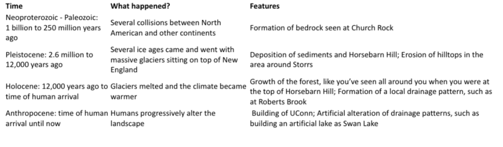
sequence of events that lead to the way UConn looks like today
look at image
minerals property hardness
minerals can be ranked on their relative hardness based on their ability to scratch one another
Mohs hardness scale 1(softest) -10 (hardest)
minerals property color
not a reliable indicator of minerals because some minerals come in many different colors or share similar colors
minerals property cleavage and fracture
how a mineral will break apart
based on weakness in crystal structure (cleavage)
for example quartz has no cleavage and will break apart in irregular fractures
cleavage is smooth, splits easily
mineral property luster
refers to how light is reflected from a mineral - glassy vs. metallic
igneous rocks textures + crystal size
The texture of an igneous rock refers to whether it formed on earths surface (volcanic or extrusive) or within earths interior (intrusive).
The size of the mineral crystals that form depends on the cooling rate
Fine grained: grains too small=rapid cooling
Coarse grained: visible grains=slow cooling
Porphyritic: mixture of fine and coarse formed from a two stage cooling process
Vesicular: contains large holes representing trapped gasses preserved in the rock
igneous rock
The color of an igneous rock is a proxy for the amount of silica (SiO2) present.
Felsic: silica rich, light colored minerals (quartz, feldspar). Light colored igneous rocks contain abundant white, pink, or translucent silica-rich minerals.
Mafic: silica poor. Dominated by silica poor dark colored minerals (olivine, pyroxene).
metamorphic rocks
foliated (layered/bonded from pressure)
contact metamorphism:
when rocks undergo metamorphism b/c they come in contact with a heat source (usually a magma body). - composition does not change but texture
regional metamorphism
when rocks undergo metamorphism usually associated with mountain building. - pressure causes sheet like minerals (mica) in rocks to rotate or grow in preferred alignment. minerals are layered parallel to each other like a stack of papers, and perpendicular to the direction of pressure (pressing down the stack of papers). - alignment of minerals into sheets is termed a foliation. - rocks lacking sheet like minerals will not create foliations.
clastic rocks sedimentary
compacted and cemented sediments of other rocks
chemical sedimentary rocks
inorganic - precipitation of dissolved minerals
biochemical sedimentary rocks
organic - take minerals out of dissolution to create shells or bones
environments of sedimentary rocks
coal → compressed plants → swamp
shale → clay, sometimes fossils → lacustrine, shallow, deep marine
limestone → carbonate, sand & silt, clay→ shallow marine
sandstone → sand, well-sorted, rounded → beach, delta, shallow marine submarine fan
breccia → large, casts, poorly sorted, angular → colluvial
chalk → clay, fine-grained, carbonates → deep water, continental shelf
gypsum → crystallite, halite, saltwater, evaporite
environment of Hartford Basin in early Jurassic period
sedimentary rocks like redbeds, mudstone, sandstones, preserve a landscape of alluvial plains, rift lakes, playas, and shorelines
topographic counter lines
lines that connect locations of equal elevation (close together = steep, far apart = gentle slope)
drawing profile
draw line down everytime countour line crosses horizontal line down to connect elevation of line
strike & dip
long axis of symbol indicates the strike, which is compass direction following rock layer underneath
dip is represented by short axis showing direction of rock layer dipping north
anticline
arcing rock layers form “A” shape
syncline
rock layers create a kind of “V” shape
discharge
volume of water moving through a stream at a given point and time (Q = velocity x A = cross-sectional)
watershed
land area where precipitation and surface water drain into a common outlet, such as stream, river, lake, or ocean
various factors influencing discharge
where is water coming from?
why are big rivers big & small streams small
where does the water come from when its not raining?
what causes increases & drops in discahrge
cross-sectional
depth x width
recurrence interval
Recurrence Interval (RI) = (N+1)/M
•N: Number of observations
–number of years in the dataset
•M: Rank value
–from 1-N observations, where 1 corresponds to the largest discharge event and N corresponds to the smallest discharge event
drainage area + source water
drainage area is size of watershed
source water is inputs that feed into watershed like snowmelt, rain, and groundwater
falls
free-fall, dominantly vertical downward movement, more as separate blocks
flows
flow over landscape, more are very viscous fluids, turbulence within moving mass
slides
slide on top of basal slip. surface that may be planar or curved, more as a semi-solid mass, some pre-slide movement
subslides
collapse into void, dominantly vertical downward movement, move as separate blocks
determine past environment based on sediment core
deep layers are older grain size and composition, plant remains, fossils, charcoal, chemical signals