IFR Ground Stage 3
 Call Kai
 Learn
Learn Practice Test
 Spaced Repetition
 Match
Match Flashcards
 Knowt Play
1/17

There's no tags or description
Looks like no tags are added yet.
Name | Mastery | Learn | Test | Matching | Spaced | Call with Kai | Chat |
|---|
No analytics yet
Send a link to your students to track their progress
18 Terms
MIA
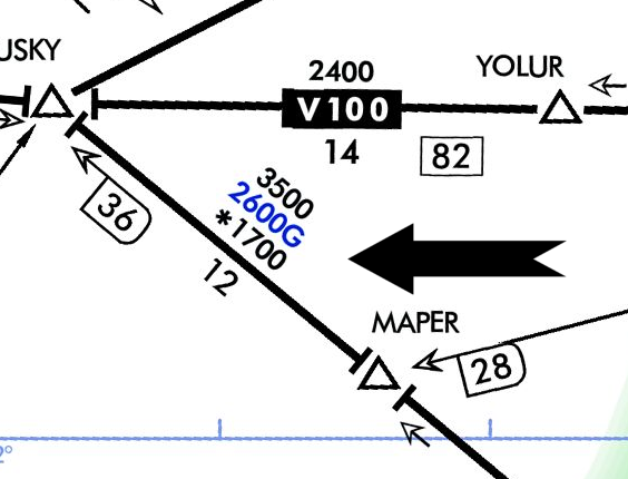
Minimum IFR Altitude, not charted
1,000 feet above the highest obstacle within a horizontal distance of 4 NM from the course; [mountains] 2,000 feet above the highest obstacle within a horizontal distance of 4 NM from the course;
LF/MF Routes
Low freq/Medium freq; Hardly exist

MEA
Minimum Enroute Altitude
The lowest published altitude between radio fixes that ensures acceptable navigational signal coverage along the entire route segment and meets obstacle clearance requirements.

MOCA
Minimum Obstruction Clearance Altitude
*Shown with asterisk
The lowest published altitude between radio fixes on VOR routes, off-airway routes, or route segments that meets obstacle clearance requirements for the entire route segment, but ensures acceptable navigational signal coverage only within 22 nautical miles of a VOR.

OROCA
Off Route Obstruction Clearance Altitude
An off-route altitude that provides 1,000 feet of obstacle clearance in non-mountainous areas and 2,000 feet in designated mountainous areas within a specific quadrangle, but does not guarantee signal coverage from ground-based navigation aids.

MAA
Max Authorized Altitude
The highest altitude or flight level authorized for a usable IFR route segment, designated to prevent interference between ground navigation signals operating on the same frequency.

MRA
Minimum Reception Altitude (shown by flag)
The lowest altitude at which an intersection can be determined using ground-based navigation aids.

MCA
Minimum Crossing Altitude (flag with X)
The lowest altitude at which a fix must be crossed when proceeding in the direction of a higher minimum en-route IFR altitude.

MTA
Minimum Turning Altitude
The lowest altitude at which an aircraft can turn to navigate a segment, providing vertical and lateral clearance from obstacles and terrain within the turn area.

MVA
Minimum Vectoring Altitude (not charted)
The lowest altitude at which air traffic controllers can issue radar vectors to IFR aircraft while maintaining required obstacle clearance
VOR COP
VOR Changeover Point
Where pilot must change nav freq to prevent loss of guidance/signal

What separation does ATC provide IFR?
5 miles laterally, 1k feet vertically, (2k feet if above FL290)
RNAV MEA
Charted in blue
TERPS
Terminal Instrument Procedures
Prescribe standardized, safe methods for designing and evaluating instrument flight procedures (IFPs) for IFR operations
Guidelines for making safe approaches
Except when necessary for takeoff or landing or unless otherwise authorized by the Administrator, the minimum altitude for IFR flight is
1,000 feet above the highest obstacle over terrain; 2000 feet over highest obstacle in mountains
What is the lowest altitude you can turn (without takeoff mins)?
400ft
What standard climb gradient do IFR procedures use?
200ft per nm