Wetlands Final
 Call Kai
 Learn
 Practice Test
 Spaced Repetition
 Match
 Flashcards
 Knowt Play
1/39

There's no tags or description
Looks like no tags are added yet.
40 Terms
What is the definition of an estuary?
body of water where a river meets the sea/where fresh water mixes with saltwater.
They are a ‘4-way ecological intersection’. With land, sea, fresh water and salt water. (ecotone)
How do estuaries function?
traps nutrients and sediment carried from the land by rivers and carried from the ocean by tides
constant mixing and ebb and flow of the tide
supports biomass, diversity of plant and animal life
unique physical-chemical conditions
What are some types of estuary habitats?
freshwater river
saltwater marsh
mud flats
eelgrass beds
mangroves
wetlands
swamps
How are estuaries beneficial to Salmon?
provide critical habitat where they adjust physiologically from fresh to salt water twice in their life cycle (once as they leave, then once again when they spawn)
How are estuaries “highly productive”?
lots of nutrients and different types of food sources
produces a lot of biomass (how much energy the system is capturing and producing)
Producers: autotrophs
Photoautotrophs like plants take sunlight and
Chemoautotroph like bacteria/algea (convert organic matter into chemicals)
converting sunlight to chemical energy
What is the energy flow of an ecosystem?
trophic cascade

How are estuaries beneficial with regards to carbon?
Carbon storage is very high. Tropical systems are more productive than temperate forests because plants can live longer and produce more leaf litter & have a longer growing season
Where does carbon energy come from?
Rivers transport carbon. The two sources of fixed carbon that drive the stream food webs include
photosynthesis outside the stream OR allochthonous OM production (riparian veg, woody material)
photosynthesis within the stream, autochthonous OM production (grab example later)
can also have other additions like riparian veg, submergent veg like eelgrass.
Carbon can also be transported by the ocean (plankton, fish)
What is sequestration?
What is blue carbon?
Sequestration: capturing and storing CO2 from the atmosphere (solid or dissolved)
blue carbon: captured, stored and released from coastal and marine habitats
Produces less GHG than their freshwater counterparts due to salinity
Lower levels of methane released in saltwater due to high levels of sulphate
Blue carbon - Snohomish Estuary
major cities are built on estuaries.
benefits include improved WQ, key habitat, protect our shorelines from storms and flooding, great carbon sinks
Blue carbon is captured, stored and released in marine habitats. Wetlands are better for storing because carbon is coming from plants that are growing. No oxygen down in the soils from waterlogging and organics don’t decompose. Wetlands build up soil very quickly (1 cm a year)
9 million tons of carbon can be stored here. The equivalent of taking 1.7 million cars off the road
Restoration of wetlands is important to bring carbon back to where it used to be.
Estuaries in BC
Total of 442
Estuaries make up 3% of BCs coastline and used by 80% of wildlife species
Eelgrass beds are the most critical for carbon capture
Economic goods of estuaries
Tourism
Fishing
Mussel Farming
Ecological goods of estuaries
carbon store
habitat for many species of plants/animals
highly productive and high nutrients
bird migration
Estuary restoration could include:
removing dykes and training walls, reconnecting the floodplain
moving log booms to drylan sorting yards
replacement of LWD
re-establishment of veg.
exclusion of non-migratory Canadian Geese
Relocation of industry where possible
Salinity in estuaries vs oceans
0.5-30 ppt creating a brackish environment
~35 ppt in oceans
Dominated by sodium and chloride and sulfate but also have magnesium. Salts come from weathering and submarine vents and leaching out of the ocean floor
Variability of salt in estuaries
salinity of estuarine water varies and can be affected by weather or tides
Salinity and climate change
salinity’s role in structuing physical and biological environments under human-induced climate change

Brackish water
supports unique plant and animal communities.
“plumes” float on top of the denser water, despite the suspended sediment load
How to tides work?
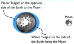
Gravitational force of moon sun and turn of earth
Gravity - anything that has mass has a gravitational force. Gravity gets weaker with distance. Moves towards the moon as the earth turns. The tidal bulge changes direction as the moon revolves around the earth.
Bay of Fundy has a 16 m tide difference
Neap tides
High or low tide is ~50 minutes later each day
semidiurnal tides are areas with two high and two low tides each day. Some areas like the Gulf of Mexico pnly have one low and one high tide each day
What affects tides
location
shape of coastline
depth of water
winds
restrictions to water flow
What are the different types of tides
semi-diurnal: two almost equal high tides and two low tides each day
diurnal tide: only one high and one low tide each day
mixed tide: two uneven tides a day
How do fresh and salt water react to temperature
Freshwater
3.98 C is the temp. for max density for freshwater. Density decreases is temp is >4 or <4
Saltwater
Density increases progressively to freezing point of -2 C. Salts add mass without adding volume
Higher density promotes sinking of cold water, which drives the global ocean circulation (thermohaline circulation)
How is depth affected in water with temp?
saltwater density decrease with ocean depth. Saltwater density at the surface is higher
The pycnocline refers to the rapid change in density with depth.
density is a function of temp and salinity
Halocline = salinity gradient
Thermocline = temperature gradient
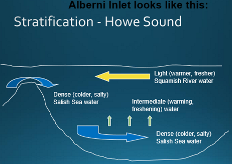
Stratified water in estuaries
warm fresh sits on top of cold salty
What are some different types of estuary habitats?
freshwater river
emergent salt marsh
mud flat
eelgrass beds
tidal channels
mangrove forests
what are the two estuary classifications
Geology
Stratification and fresh-seawater circulation
Explain drowned river valleys
formed at the end of the ice age
glaciers receded and melted, sea levels rose and inundated river valleys
valleys are usually shallow with gentle sloping bottom
sediment accumulates within the river valley
very common
Explain Fjord-type estuaries
Fjords are valleys that have been cut deeper by moving glaciers and then invaded by the sea
Created by glacial action, characterized by the steep slope of adjacent lands and great depth
Sill near ocean limits seawater influx into fjord
found in areas once covered by glaciers
shallow sill near their mouth that limits water exchange between the deeper waters of the fjord and sea
Explain tectonic estuaries
movement in the earth’s crust causes a large piece of land to sink (subside) producing a depression that is infilled by seawater
created when the sea fills in the hole or basin that was formed by sinking land
Explain delta estuaries
form at the mouths of large rivers, when sediment and silt accumulate rather than being washed away by currents or ocean waves
complex set of channels and marshes form at the mouth of the river
sediments continue to accumulate seaward
Explain bar-built estuaries
rarest type of estuary on the west coast
formed by ocean waves and currents pushing sediments shoreward, building up sandbars and forming barrier islands
stream typically has low flow (high salinity)
storms or floods may breach the bar/ Bars may grow into barrier islands and estuary can become permanently blocked
Explain lagoons
a feature of some bar-built estuaries (not technically its own class of geological estuaries)
area where barrier beach creates an area of protected calm water
What are the five types of stratification and circulation of estuaries
salt-wedge
Fjord
slightly stratified
vertically mixed
freshwater
How is the circulation and stratification measured between salt and fresh water
Isohalines - area in the water of equal salinity. The shape of the isohaline indicates the amount of mixing and can give clues on the underlying geology
Describe a salt-wedge estuary
most stratified (least mixed)
occurs when a rapidly flowing river discharge into the ocean where tidal currents are weak
location of the wedge varies with the weather and tidal conditions and discharge
EX. Fraser River
Describe a Fjord-type estuary
found along de-glaciated coastlines
sill at entrance restricts water circulation and dense seawater seldom flows up over the sill into the estuary
very little tidal mixing, the water remains highly stratified
Describe slightly stratified estuaries
“partially mixed”
saltwater and freshwater mix at all depths
salt water is mixed upward and fresh is mixed downward
lower layers typically remain saltier than upper layers
Describe vertically mixed estuaries
occurs when river flow is low and tidal currents are moderate to strong
strong tidal currents eliminate layering of freshwater above seawater
salinity is the same from water surface to the bottom of the estuary due to strong tidal currents
found in large, shallow estuaries
Describe freshwater estuaries
exclusive to the great lakes
not seawater but a chemically-distinct combo of river and lake waters
storm drive - seitches. They are caused when strong winds and rapid changes in atmospheric pressure push water from one end of a body of water to the other
semi-enclosed bay areas in which the lake water becomes mixed with water from the river or stream
Are classifications of estuaries static?
No! estuarine classification is a complex matter and can change. They are constantly being affected by tidal and wave action, prevailing and changing winds, local and distant weather systems, variations of rainfall runoff and river discharge, geology, human modifications and more!