paper 1 geography
 Call Kai
 Learn
 Practice Test
 Spaced Repetition
 Match
 Flashcards
 Knowt Play
1/211

Earn XP
Description and Tags
does not include case studys- paper 1: natural hazards, living world, physical landscapes: rivers and coasts- NO GLACIERS
212 Terms
what factors affect the risk of natural hazards
urbanisation- densely populated urban areas increase risk
poverty- housing shortage leads to building on risky grounds
farming- fertile silts, volcanic ash
climate change- global sea levels rising - more extreme weather
structures of the earth
inner core —> outer core —> mantle —> crust
features of the continental crust
older, less dense, 30-50m thick
features of oceanic crust
younger, denser, 5-10km thick
evidence for tectonic theory
fossil records- animals separated by huge oceans- land must be together
continents fit together
mountain range used to connect geology seems to match

conservative plate boundaries
when two plates move past eachother in same or opposite directions at different speeds
friction between plates cause them to become stuck, stress builds released by seismic waves
earthquakes

destructive plate boundaries
when two plates move towards each other- oceanic and continental
oceanic is subducted
volcanos and earthquakes

collision plate boundaries
when two continental plats head towards each other
forming mountain ranges, no volcanoes because there is no magma
earthquakes

conservative plate boundaries
two plates moving away from each other
gap between plates force magma to rise
earthquakes, volcano
advantages of living close to places of tectonic hazards
fertile land- volcanic ash has minerals for growing crops
poverty- cheaper housing, geothermal energy
lack of education- limited knowledge of the hazards
job opportunities- tourism
family links
mining- sulphur
geothermal energy
disadvatanges of living at areas at risk from tectonic hazards
high injury and death risk
possible loss of homes and livelihoods
costs of rebuilding
what year was nepal lic- earthquake
2015
what year was chile hic- earthquake
2010
how is monitoring used in volcanoes
seismometer- detect and record microquakes
tiltometers- monitor ground deformation as magma rises
instruments- monitor gas emissions and change in water chemistry
how is monitoring used in earthquakes
generally occur without warning, network of seismometer monitor and record them
how is monitoring systems used in tsunamis
monitor systems in pacific and Indian oceans use floating boys to detect are tsunamis following an earthquake
how is protection used in volcanoes
earth embankments have been used to successfully divert lave flows. Weirs and small dams control lahars
how is protection used in earthquakes
earthquake resistant buildings (aseismic) are designed to withstand earthquakes
how are protections used for tsunamis
sea walls can help defend against tsunami waves
how is prediction used for volcanoes
due to monitoring we can now detect when we think eruptions could occur allowing accurate evacuations
how can prediction work for earthquakes
impossible to accurately predict, but can use past quakes to see where could be most at risk
how can planning work for volcanoes
hazard mapping shows areas most at risk, allowing these areas to create evacuation packs and evacuation routes
how can planning work for earthquakes
shakemaps locate areas at least risk in areas of which we can locate high-value desserts
what direction to surface move
high to low pressure
why is the UK weather like this
Cloudy and wet weather in the UK is because it is located 50-60 N and is close to where cold polar air from the north meets the warm subtropical air from the south.
These surface winds from south-west usually bring warm and wet weather because of rising air cooling and condensing forming clouds and rain
why are deserts like this- GAM
Because most deserts are found about 30 N and S where sinking air means high pressure, little rain, hot day and cold night temperatures
why are tropical rainforest like this
because they are found at the equator
low pressure as sun is directly overhead
hot humid air rises, cools and condense causing heavy rain
how are tropical storms formed
- Triggered by upward movement of evaporated air and moisture
- Rising air draws huge quantities of evaporated water vapour from ocean surface which cools and condenses to form towering thunderstorm clouds
- Condensation releases heat which powers the storm and draws yet more water vapour
- Multiple localised thunderstorms coalesce to form a giant rotating storm
- Coriolis forces spin the storm creating a cloud spiral
- Prevailing winds drift the storm over the ocean- gathering energy
what is needed for a tropical storm to form
· 5-15 degrees north and south of the equator
· Ocean temperatures above 27 degrees
· Ocean 50 meters deep
· Coriolis effect
· Intense heat and humidity for air rising
why do tropical storms loose energy when they make landfall
because water is energy soruce
what is the structure of a tropical storm
Centre: eye- a column of rapidly sinking cool air- conditions are relativity calm with no clouds
Outer edge of eye: eye wall- conditions are very strong and torrential rain
Coulombs clouds- swirl around bringing additional bands of rain

why are tropical storms become more frequent
Climate change= temperature increase= sea temperatures rise= sea temp above 27c more= more tropical storms
monitoring and prediction for TS
Tropical storms cannot be prevented but can be monitored to predict tracks
Tracking includes satellite and radar.
This allows local governments to issue warnings and evacuations
how is protection used for TS
Reinforcing wall, windows and roofs and building homes on stilts can help
Cyclone shelters can be used as community centres, schools for majority of time
how is planning used for TS
Creating contingency plans for evacuation routes
Educations and media campaigns to raise awareness of dangers
what is the greenhouse effect
Greenhouse effect keeps the naturally warm enough to support life on earth
- Greenhouse gases trap heat that would otherwise escape atmosphere
- Allows short wave radiation from sun to earth
- Traps longer wavelength radiation (heat) that would be radiated back into atmosphere
what are the UK’s weather hazards
Thunderstorms
Prolonged rainfall à floods
Droughts and extreme heats
Heavy snow and extreme cold
Strong winds
short term evidence for climate change
extent of artic sea ice, glacial retreat, temperature records
how does extent of artic sea ice give evidence for CC
50% less sea ice then there was 30 years ago, sea temperatures appear to be getting warmer- with permeant ice covering decreasing 9% a decade. Extremely reliable
how does the rate of glacial retreat give evidence for CC
glaciers have been melting as temperatures increase. Extremely reliable
how do temperature records give evdience for climate change
since 1850’s been using thermometers to track temperature changes. Very reliable and accurate data
long term evidence for cliamte change
dendrochronology, ice cores, sediment cores
how is dendrochronology evidence for cliamte change
each tree ring represents a year of growth; thicker tree rings show warmer and wetter temperatures. They date back around 10,000 years, using modern data sets can be quite reliable
how are ice cores evidence for cliamte chagne
contain tiny bubbles of atmosphere within them. shows the evidence of amount of greenhouse gases present go back 1 million years, reliable
how are sediment cores used for climate change evidence
contain microfossils and pollen which can give indications of climate, can go back many millions of years but less reliable
what human causes are there for climate change
deforesation, fossil fules, agricutlure
how does deforestation cause climate change
occurs due to agriculture, urban areas and roads needing space, it stops the carbon oxygen exchange loosing carbon sinks
how does agriculture cause climate change
causes deforestation, cattle farming releases huge amounts of methane, NPK fertilisers and pesticides have nitrous oxides within them- 300x more effective at trapping heat then CO2
what natural causes are there for climate change
solar output, milankovitch cycles, volcanic activity
how does solar output cause climate change
sunspots are darker patches on the face of the sun, the more sunspots the more solar output- 11 year cycle from maximum to minimum
how do Milankovitch cycles cause climate change
the sun eccentrically orbits the earth. Every 100,000 years it moves from circular orbit into an oval elliptical orbit, it rotates on a tilted axis accounting for seasonal change. Precession the earth rotates as it wobbles causing climate changes
how does volcanic activity cause climate change
eruptions release gas and large amounts of ash (short term) ash blocks the sun causing global dimming, sulphur dioxide is released and mixes with water in the atmosphere creating sulphuric acid= tiny mirrors reflecting the sun
how can we manage climate change
alternate energy sources, carbon capture, planting trees, international agreements
how can we use alternate energy sources to mange climate change
Such as hydroelectric power, nuclear power, solar, w2ind and tidal are low carbon emission alternative to fossil fuels to create energy
how can we use carbon capture to manage climate change
technology to capture co2 that is produced by burning fossil fuels in electrical generation and industrial process. Once capture co2 is compressed and injected underground for storage in reservoirs- depleted oil and gas wells
how can we use tree planting to manage climate change
trees act as carbon sinks removing cos from atmosphere by photosynthesis. They also released moisture producing more clouds so reducing incoming solar radiations. Afforestation and reforestation can be implemented to create more land-based carbon sinks
how can international agreements manage climate change
Paris agreement in 2016 was first legally binding global climate deal aiming to limit global temperature increase to 1.5c above pre-industrial levels
how can we adapt to climate change
changing agricultural systems, manage water supply, reduce impact from sea level changes
how can we adapt to climate change through reducing impact from sea level change
- Sea walls
- Raised housing
- Artificial islands
- Resorting coastal mangroves
how can we adapt to climate change by changing agricultural systems
- Cope with extreme weather
- Manage water supply by storing water: irrigation systems, drought-resistant crops, adapt seasonally
how can we adapt to climate change through managing water supply
- Constructing reservoirs to store water
- Transferring water from areas of surplus to areas of deficit
- Grey water (clean waste water)for irrigation
- Constructing desalination plants to convert seawater to freshwater
- Improving water conservation to reduce waste
what is an ecosystem
complex natural system made up of plants, animals and the environment- that are interdependent on each other
what are biotic feature of an ecosystem
living features of ecosystem- plants, animals and fish
what are abiotic features of ecosystems
non-living environmental factors - climate, soil, light
what are producers
convert energy from environment into sugars- plants covert energy from the sun by photosynthesis into glucose
what are consumers
get energy from sugars produced by producers- pond snail that eats plants
what are decomposers
break down plant and animal material returning the nutrients to the soil bacteria and fungi
what is the nutrient cycle
when plants or animals die, the decomposers help to recycle the nutrients, making them available once again for growth of plants and animals
what is a food chain
show the direct links between producers and consumers in the form of a simple line
what is a food web
shows all the connection between producers and consumers in a complex way
natural changes in an ecosystem
like droughts or other extreme weather- can kill parts of ecosystems and then animals dependent on them
what are human changes in an ecosystem
Agricultural fertilisers can lead to eutrophication as the nitrates increase growth of algae which depletes oxygen and fish may die
Hedgerows and grass margins protect wildlife such as bees, insects and wildflowers, when they are removed to increase size of grazing fields habitats will be destroyed
Ponds may be drained to use for farming aquatic plants will die and animals’ dependant on the aquatic life
why do biomes form parallel to lines of latitude
climate and characteristics of ecosystems are determined by the global atmospheric circulation
tropical rainforest- biome facts
cover 6% of land,
half of all plant and animal species
1/4 of world medicine
mainly close to equator- high temps and heavy rainfall
desert biome facts
1/5 of the earths land, high temps, less then 250mm rainfall, highly specialised species
Mediterranean biome facts
south of tropic of cancer, hot sunny and dry summers, mild winters- olives and citrus fruits
tundra biome facts
located 60-70 north- cold, windy and dry conditions support low-growing plants easily damaged by development- e.g. oil exploitation and tourism
location of tropical rainforests
located mostly a few degrees north and south of the equator
what climate do tropical forests thrive in
thrive in the equatorial climates where:
Temperatures are high throughout the year- averaging 27c- because sun is mostly overhead
Rainfall is over 2000m a year because GAC causes an area of low pressure to form at the Equator. The rising air creates clouds and triggers heavy rain
Variation in rainfall is due to months where the equatorial low pressure area is directly overhead causing a distinct wet seasons of intense rainfall
latosols charecteristics in tropical rainforests
are typically old, deep, iron-rich so red in colour (minerals come from weathered rock below)
why are latosols in TF infertile
because they are prone to rapid leaching where minerals are lost in solution and nutrient cycling is rapid.
what is the nutrient cycling in TF
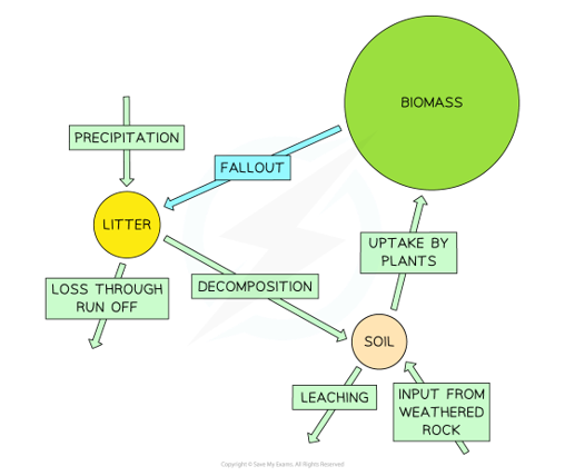
the majority of nutrients are stored in the biomass- lush vegetation
few nutrients are stored as litter. This is due to the rapid decomposition by fungi and bacteria
few nutrients are stored in soil. This is due to the rapid uptake by plants and significant leaching
why have plants adapted in tropical rainforests
Through stratification, tropical rainforest vegetation had adapted to cope with:
- Competition for sunlight
- Shortages of nutrients available
- Competition for space
layers of trees in TF
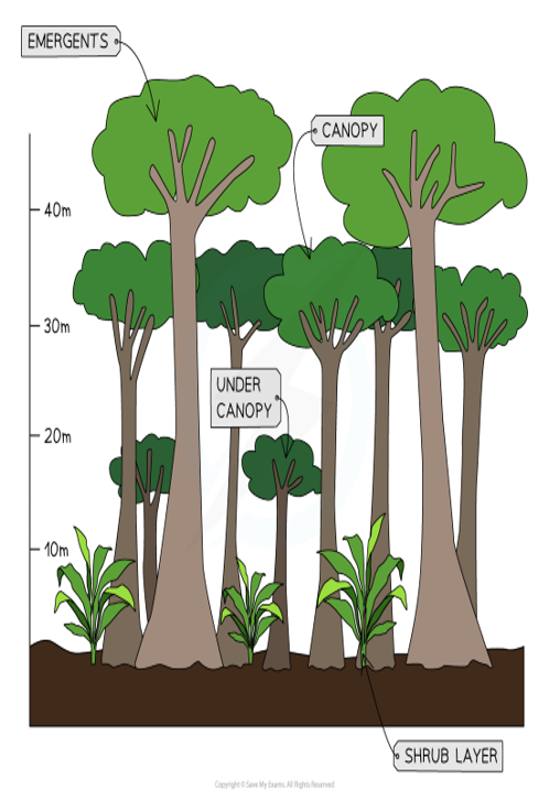
Top canopy (35-50m)- Hardly exposed emergent trees with straight branchless trunks receive the most light
Middle canopy (20-35)- Most productive layer as each tree has enormous photosynthetic surface of dark leathery leaves. Dip tips- shed water quickly and efficiently
Lower tree canopy (10-20m)- Shaded less substantial trees waiting to take advantage of the next available light. Interlocking soundly branches, lianas
Shrub and ground layer (0-10m)- Limited to ferns and woody plants due to lack of light. Bacteria and fungi rapidly rot the fallen leaves, dead plants and animals. Thick buttress roots help to spread weight of the trees above
Latosols- cycle nutrients rapidly to support new growth, can be exposed to leaching and exhausted of stored nutrients
adaptions of plants in TF
Adaptation 1) trees grow upwards very quickly to reach sunlight, trunks tend to be straight and branchless as all energy is concentrated on growing taller
Adaptation 2) buttress roots- base of the tree is wide and triangular to support it
Adaptation 3) shallow roots- because water and nutrients needed are upper layer of soil
Adaptation 4) flexible slim trunks to withstand winds in upper canopy
Adaptation 5) leaves in the emergent canopy have large surface areas to maximise sunlight absorption
Adaptation 6) canopy dense cover of leaves which absorbs almost 70% of sunlight and 80% of rainfall
Adaptation 7) little undergrowth- less than 5% of sun’s rays reach this layer
Adaptation 8) dead trees rot quickly because of heat and water available. Adding nutrients to surface which are quickly used by other plants to grow
Adaptation 9) lianas use other trees to reach canopy/ sunlight because there is not as much light at ground level so need to in order to survive
Adaptation 10) drip tips which allow excess water to easily fall to the forest floor, prevents stem snapping due to water weight
Adaptation 11) leaves are waxy and thick to help them withstand strong sunlight and prevent water loss form surface of plant
how have animals adapted to living in rainforests
- Poisonous- protect themselves from predators or to catch prey, some tribes use poisons on end of hunting arrows to help them hunt
- Mimicry- pretend to be an animal they are not but look similar too in order to pretend to have their features (poisons etc)
- Limiting diets- consume foods that only they can access- prevents lack of food- e.g. toucans only consume fruits that only they can access
- Habitat adaptions- e.g. sloths have long arms and claws to live in treetops
- Camouflage, enables creatures to blend into natural
- Three-toed sloth has adapted to the hot conditions by having a very slow metabolism
sloth adaptions
long arms and claws to live in treetops
slow metabolisms for hot conditions
algae on feet for nutrients and camouflage
why is biodiversty under threat in TF
- Deforestation- replacing rainforests with pasture, commercial plantations and settlements
- Water pollution- gold and other mining which is poisonous to river reduces aquatic life and kills wildlife
- Climate change- deforestations reduces evapotranspiration causing climate drying
causes of deforestation
- Logging- however selective logging is better than clear felling
- Road building- provide access to logging and mining areas, new settlements and energy projects
- Hydroelectric power- boosts Malaysia’s electricity supplies
- Mineral extraction- tin mining is established and drilling for oil and gas
- Settlement and population growth- people encouraged to move into the countryside- transmigration has set up new settlements
- Commercial farming- largest exporters of palm oil in the world. Ten year tax incentives encourage more deforestation from plantations
- Substance farming- short-term clearance is small scale and sustainable, but ‘slash and burn’ fire can grow out of control destroying large areas
impacts of deforestation- TF
Deforestation destroys the ecosystem and many habitats. Stripping away vegetation:
- Reduces biodiversity
- Losses of species, medicinal products
- Exposes the ground- soil erosion by wind and rain
- Contributes to climate change
development caused of deforesation
Economic gains:
- Job creation
- Tax revenue
- Improved infrastructure
- Plantation products support industries
- HEP is cheap and plentiful
- Minerals extraction
Economic issues:
- Lack of water- limit supplies
- Fires pollute and destroy vast areas of valuable forest
- Rising temperatures
- Medicinal plants could become extinct
- Tourism could decrease
- Climate change
value of tropical rainforests
Indigenous people living sustainably:
- Around 50 million people living in the tropical rainforests
- Rely on rainforest for food, water and shelter
- Nomadic- hunter gatherers which is a sustainable lifestyle not farming the rainforest
Medicinal plants
- 25% of drugs used today are derived from rainforest plants:
o Quinine- treat malaria
o Extract from liana bark- treat Parkinson’s disease
o Wild yams- birth control
o Vampire bat- saliva prevents heart attacks
Resources:
- Valuable hardwoods
- Rich mineral resources
To the environment: biodiversity, carbon sinks, water, climate (20% of the world oxygen)
sustainable managing the rainforests
- Selective logging and replanting- avoiding destructive clear felling
- Conservation and education- promotes preservation
- Ecotourism
- International agreements
physical characteristics of deserts
Deserts are arid areas. Hot temperatures in the day, cold temperatures at night, less than 250mm rainfall per year.
Location: Found between 30N and 30S of equator
why is are the temperatures like this in a deserts
Found between 30N and 30S of equator at these latitudes air has risen from equator sinks forming a persistent belt of high pressure. Therefore, there is a lack of cloud and rain, and extreme temperature range- hot day, cold night.
characteristics of soil in deserts
Soil tends to be sandy or stony. There is limited leafy vegetation meaning little organic matter and fertility. Evaporation of moisture draws salt to surface
interdependence of animals in deserts
- Animals adapt to store water, lose heat and seek shelter from the sun
o E.g. rodents burrowing into the loose, sandy soil for shade
interdependence of plants in deserts
- Plants seeds remain dormant for years, bursting into life when infrequent rainstorms finally arrive
interdependence of people in deserts
- Traditional people are pastoralist, sustainably migrating with animals to fresh pastures water by seasonal rainfall, avoiding overgrazing
general plant adaptations in deserts
- Small leaves, spined and waxy surface- reduce transpiration
- Succulent store water in leaves, roots, stems or fruit
- Seeds are dormant for years germinate quickly when it rains
- Long taproots reach groundwater- rest are shallow roots to find water reaching surface to evaporate