APES Unit 4 Earth's system and resources
 Call Kai
 Learn
Learn Practice Test
 Spaced Repetition
 Match
Match Flashcards
 Knowt Play
1/95

There's no tags or description
Looks like no tags are added yet.
Name | Mastery | Learn | Test | Matching | Spaced | Call with Kai | Chat |
|---|
No analytics yet
Send a link to your students to track their progress
96 Terms
Earth’s Atmosphere
The thin layer of gases surrounding Earth, Gravity holds these gases close to the surface.
How does Earth’s Atmosphere make life possible?
Giving oxygen → Respiration
Supplying carbon dioxide → Photosynthesis
Protecting Earth from radiation
Regulates Earth’s Temperature
Composition of Earth’s Atmosphere:
Nitrogen → 78%
Oxygen → 21%
Argon → 0.93%
Carbon dioxide → ~ 0.04%
Water Vapor → 0 - 4% (depending on location and water
Relationship: Air pressure and Altitude
Air pressure goes down as Altitude goes up
Air pressure goes down as Altitude goes up because…
Gravity pulls air molecules towards the earth
Most air molecules are concentrated in the lower atmosphere
As you move higher, there are fewer air molecules to press you down
Layers of the Atmosphere:
Exosphere
Thermosphere
Mesosphere
Stratosphere
Troposphere
Exosphere
Exo = outside
Gradually fades into space
Thermosphere
Thermo = heat
Auroras occur
Temperature increases
Mesosphere
Meso = middle
Meteors burn up
Temperature decreases
Stratosphere
Strato = layer
Contains the ozon layer
Temperature increases
Troposphere
Tropo = turning
Weather occurs here
Temperature decreases
The Greenhouse Effect steps
Solar radiation passes through the atmosphere
Earth’s surface absorbs the energy and warms
The warm surface releases heat radiation back
Greenhouse gases absorb and re-radiate some of this heat
Some heat escapes to space, while some is trapped near Earth’s surface

Without Greenhouse effect..
Avg. Earth temp, would be about -18 C
Actually avg. temp. is about 15 C
Life as we know it would not exist
Why is Climate change bad?
Climate change makes this too much which is bad but greenhouse effect isn’t.

Major Greenhouse Gases:
Water vapor → evaporation
Carbon dioxide → fossil fuels combustion
Methane → Livestock, landfills, natural gases
Nitrous oxide → Fertilizers, agriculture
Chlorofluorocarbon → Refrigerants and industrial chemicals (only one that’s caused just by humans)

The Enhanced Greenhouse Effect
More greenhouse gases trap more heat in the atmosphere
More CO2, less heat escapes to space, earth gets warmer
Solar Radiation
also known as Insolation means incoming solar radiation reaching earth
Solar energy drives:
Weather
Climate
Winds
Ocean currents
The water cycle
Photosynthesis
Sunlight angles
Earth is a sphere, so sunlight strikes different locations at different angles
The amount of heating depends on..
Surface Albedo
Sun Angle
Latitude
Day length
Albedo
How reflective something is
Low Albedo surfaces
Forests, Oceans, Asphalt
Absorbs more sunlight → becomes warmer
High Albedo Surfaces
Snow, Ice, Clouds
Reflect more sunlight → Remains cooler
Direct Sunlight
High sun angle
Energy concentrated over smaller areas
More Intense heating
Indirect Sunlight
Low sun angle
Energy spreads over a larger area
Less intense heating
What changes the sun angles?
Latitude
Sun angle: Poles
Sunlight strikes at a lower angle
Solar energy spreads over a larger area
Lowest solar radiation
Sun Angle: Equator
Sunlight strikes more directly
Solar energy is concentrated
Highest solar radiation
Relationship: Atmosphere and Solar energy
More Atmosphere = Less Solar Energy
Atmosphere vs Solar energy: Poles
Sunlight travels through more atmosphere
More Energy is lost before reaching Earth’s surface
Atmosphere vs. Solar Energy: Equator
Sunlight travels through less atmosphere
Less energy is scattered or absorbed
Earth’s rotation
Earth rotates on its axis once every 24 hours, causing day and night
Earth’s Tilt
Earth’s axis is tilted 23.5 degree
The axis always points in the same direction as Earth revolves
Earth’s title causes changes in day length throughout the year.
Tilted away → Shorter daylight
Tilted towards → Longer daylight
There is an unequal heating of Earth because…
Polar regions receive much less solar radiation
The equator receives the most direct solar radiation
This uneven heating creates temperature difference across Earth
Which way does air move?
Air naturally moves from high pressure to low pressure
This horizontal movement of air is called wind
Without pressure differences, wind would not exist
What creates warm and cold air?
Unequal heating creates warm and cold air, changing air density
Warm air rises cold air sinks
This creates pressure differences causing air to move from high pressure to low pressure (wind)

Convection
the transfer of heat through the physical movement of fluids, including liquids and gases
Atmospheric circulation steps:
Warm air rises near the equator
Air moves away from the equator
Cool air sinks near the poles
Surface winds return toward the equator

The three circulation cells are…
Hadley Cell
Ferrel Cell
Polar Cell
What do the circulation cells do?
These cells redistribute heat from the equator toward the poles
Hadley cell
Warm air rises near the equator.
Air cools, loses moisture, and sinks near 30° N/S.
Creates wet tropical regions and dry deserts.
Ferrel Cell
Surface air moves toward the poles and rises near 60° N/S.
Air cools and sinks near 30° N/S
Creates mid-latitude weather patterns.
Polar Cell
Cold, dense air sinks at the poles.
Surface air moves toward 60° N/S and rises.
Creates cold, dry polar climates.
Picture of the three circulation cells

Picture of the Global circulation patterns relating to the environmental condition

Jet streams
Fast-moving bands of air in the upper troposphere
Form near boundaries between circulation cells
Move weather systems around Earth
Influence climate and precipitation patterns
Examples:
Polar Jet Stream (~60° N/S)
Subtropical Jet Stream (~30° N/S)

How does wind move?

The Coriolis Effect
Moving air appears to curve, the apparent deflection of moving air caused by Earth’s rotation. It changes wind directions, not wind speed.
Wind deflection depends on hemisphere
Northern Hemisphere: Winds curve to the right
Southern Hemisphere: Winds curve to the left
The Coriolis Effect: Equator vs. Poles
The closer you are to the equator, the faster the Earth rotates because that region must travel a much larger distance in a 24 hour day than the area near the poles.
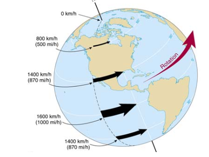
Type of Winds
Trade Winds
Westerlies
Polar Easterlies

Trade Winds
Move toward the equator
Westerlies
move toward the poles
Polar Easterlies
Move away from the poles
Earth’s Structure & Layers
Crust
Thin, outermost solid layer of Earth where life exists
Lithosphere
Rigid outer layer made of the crust and uppermost mantle
Broken into large pieces called tectonic plates
Asthenosphere
Hot, solid rock beneath the lithosphere
Flows slowly over long periods of time, allowing tectonic plates to move
Mantle
Thickest layer of Earth
Made of hot, mostly solid rock that slowly circulates through convection currents, driving plate movement
Core
Composed mainly of iron and nickel
Extremely hot and provides the heat that drives convection within the mantle
Why isn’t the Earth’s surface fixed?
The lithosphere is broken into moving tectonic plates
Plate movement shapes Earth’s landscapes and creates natural hazards
Where do most of the earthquakes happen?
on the tectonic plate boundaries

What causes plates to move?
Earth’s core provides heat
Heat creates convection currents in the mantle
Convection slowly moves tectonic plates
Picture of the convection Currents:

Types of Plate Boundaries
Divergent Plate Boundary
Convergent Plate Boundary
Transform Fault Plate Boundary
Divergent Plate Boundaries
Plates move apart
Constructive boundary
New crust forms

Convergent Plate Boundaries
Plate collide
Destructive boundary
Crust is recycled

Transform Fault Plate Boundaries
Plates slide past
Conservative boundary
No crust formation or recycling

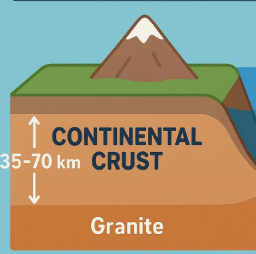
Continental Crust
Made mainly of granite (less dense rock)
Thicker
Generally less dense
Much older
Form the continents
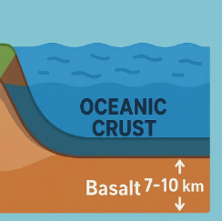
Oceanic Crust
Made mainly of Basalt (denser rock)
Thinner
More dense
Younger
Form the ocean floor
Divergent Boundaries: Oceanic - Oceanic
New oceanic crust forms
Plates move apart
Magma rises
Seafloor spreading
Mid - Ocean ridges

Divergent Boundaries: Continental - Continental
Plates move apart
Continental crust stretches and thins
Magma rises through cracks
Rift valleys form
New Ocean basins may eventually form

Convergent Boundaries: Oceanic - Oceanic
One oceanic plate subducts beneath the other
Magma rises to form volcanic islands
Forms:
Volcanic island arcs
Deep ocean trenches
Earthquakes
Example: Japan or the Aleutian islands

Convergent Boundaries: Oceanic - Continental
The denser oceanic plate subducts beneath the continental plate
Partial melting produces magma that rises to the surface
Forms:
Volcanoes
Coastal mountain ranges
Deep Ocean Trenches
Earthquakes
Example: Andes Mountains

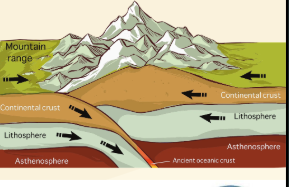
Convergent Boundaries: Continental - Continental
Neither plate is dense enough to fully subduct
The plates collide and buckle upward
Forms:
Large mountain ranges
Strong earthquakes
Little to no volcanic activity
Example: Himalayas
Transform Boundaries
Plates slide past
No crust created
No crust destroyed
Stress builds (potential energy stored)
Earthquakes occur (kinetic energy released)
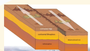
Where is each type of boundary? (picture)

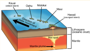
Hot spots
Areas where hot mantle material rises toward Earth’s surface
Create volcanoes away from plate boundaries
Moving tectonic plates over stationary hot spots form volcanic island chains
Example: Hawaiian island
The Ocean and Atmosphere are connected
The ocean and atmosphere constantly exchange heat, moisture, and energy
The surface waters of the ocean absorb solar energy
Warm ocean water heats the air above it
Warm water also increases evaporation, adding moisture to the atmosphere
Warm, moist air becomes less dense and rises
Rising air helps drive atmospheric circulation

Gyres
Large ocean cricles patterns due to global win
(clockwise in N hem, counterclockwise in S hem.)

Normal Conditions in Tropical Pacific
Trade winds create an uneven distribution of ocean temperatures
Trade winds push warm surface water from east to west
Warm water accumulates near Indonesia and Australia
The western Pacific becomes warmer than the Eastern Pacific
The western Pacific becomes warmer than the eastern Pacific
Cold, nutrient - rich water rises along the west coast of South America (upwelling)

Upwelling
Upwelling is when deep, cold ocean water rises to the surface, bringing the nutrients that supports marine ecosystems.
often caused by surface winds pushing warm surface water away

Why is Upwelling important?
Brings nutrients from deeper waters to the oceans surface
Supports high biological productivity
Creates some of the world’s most productive fishing regions
What is Walker Circulation?
The temperature difference across the pacific drives an east - west atmospheric circulation called walker circulation
Walker Circulation steps:
Warm ocean water heats the air above it
Warm, moist air rises over the western Pacific
Air moves eastward high in the atmosphere
Cooler, drier air sinks over the eastern Pacific
Surface trade winds complete the circulation

Hadley cells vs. Walker
Hadley cell: moves air north and south between the equator and 30 degree latitude
Walker: Moves air east and west alone the equator

El Nino: Walker Circulation weakens
Trade winds weaken
Warm surface water shifts eastward
Upwelling decreases
The eastern Pacific become warmer than normal
Rising air and rainfall shift toward the central and eastern Pacific
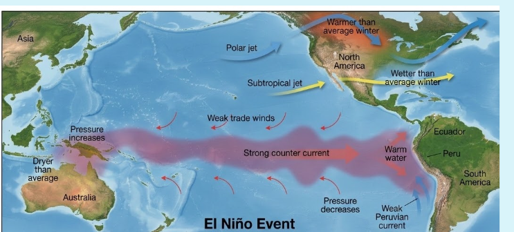
Picture of the difference between Normal conditions and El Nino

La Nina: Walker Circulation Strengthens
Trade winds strengthen
More warm water is pushed westward
Upwelling increases
The eastern Pacific becomes cooler than normal
Rising air and rainfall become even more concentrated over the western Pacific
Picture of the difference between Normal conditions and La Nina

Compare and Contrast El Nino and La Nina
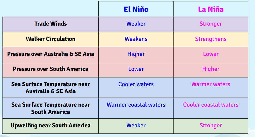
Global weather patterns Change during El Nino and La Nina

Watershed
An area of land that channels rainfall, snowmelt and runoff downhill into a shared body of water like a stream, river, lake or ocean.
Rain shadow effect:
Wind pushed air up the mountain, causing it to cool
Cool air forms clouds and releases rain or snow on the windward side
After crossing the mountains the air descends and warms
The leeward side becomes dry because the air has lost most of its moisture
This dry area is called a rain shadow
Climate patterns are affected by…
Latitude
Topography
Atmosphere
Ocean currents
Distance from Oceans
Latitude
Dictates solar intensity, direct sunlight makes the equator warm, while angles sunlight makes the poles cold
Topography
Higher elevations are colder, and mountain ranges create wet windward sides and dry leeward “rain shadows”
Atmospheric Circulations
Global winds move heat and moisture, creating rainy zones where air rises and dry deserts where air sinks
Ocean currents:
Warm currents bring heat and rain to coastal areas, while cold currents bring cooler, drier conditions
Distance from oceans
Water moderates temperature, keeping coastal regions mild while inland areas suffer extreme hot and cold seasons