CHUG :o
 Call Kai
 Learn
 Practice Test
 Spaced Repetition
 Match
 Flashcards
 Knowt Play
1/133

There's no tags or description
Looks like no tags are added yet.
134 Terms

Weather camera

What is the dark blue area?
Inland water

What is the light blue area?
Open water
What are the intervals for basic contours?
500’
What are the intervals for intermediate contours?
250’
What are the intervals for auxiliary contours? (4)
50’, 100’, 125’, 150’
Where is the sun projecting from to create shadows on the sectional chart?
Northwest
What does “UC” mean for an obstacle?
Under construction
When are man-made obstacles depicted on a sectional? (natural area)
When extending MORE than 200’ AGL
When are man-made obstacles depicted on a sectional? (yellow city tint)
When extending MORE than 299’ AGL
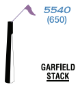
What is the top blue number?
Elevation in MSL

What is the bottom blue number in perentheses?
Elevation in AGL

What is special about these obstacles/what do they have?
High-intensity strobe lighting that operates either part-time or by proximity activation

What is depicted? What is the boxed number?
Wind turbine farm
Elevation in MSL of the highest wind turbine within the area
How is the MEF calculated for a man-made obstacle?
When an obstacle is more than 200’ above the highest terrain within the quadrant:
Determine the elevation of the top of the obstacle in MSL
Add 100’ for possible vertical error
Round up to the next hundred
How is the MEF calculated for natural terrain?
When a natural terrain feature is the highest in the quadrangle:
Determine the elevation of the feature
Add 100’ for possible vertical error
Add 200’ for uncharted natural or manmade obstacles
Round up to the next hundred

Mountain pass

What does the “122.2” on top of the box mean?
FSS radio frequency

What does “PHOENIX” mean?
The name of the nav aid
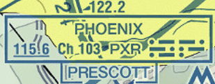
What does the “115.6” mean?
Frequency of the nav aid

Why is “115.6” underlined?
There is no voice communications with flight service on that frequency

What does “PXR” mean?
The identifier of the nav aid

What are the dots and dashes on the bottom right corner of the box?
The morse code for the nav aid

What does “PRESCOTT” under the box mean?
The FSS that controls the nav aid

Hard surface runways greater than 8069’ OR some multiple runways less than 8069’

Hard surfaced runways between 1500’ - 8069’

Other than hard-surfaced runways

Seaplane base

Other than hard-surfaced runways for military airports

What are the tick marks on the sides of the airport symbol?
There is fuel available; check the chart supplement/AFD for more details

What does “NO SVFR” mean?
Special VFR ops are prohibited for fixed-wing aircraft

What does “HNL” mean?
Location identifier

What does “PHNL” mean?
ICAO location identifier
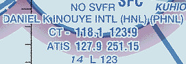
What does “CT - 118.1 123.9” mean?
Control tower primary frequencies

What does “ATIS 127.9 251.15” mean?
The ATIS frequencies

What does the “14” mean?
The airport elevation

What does the “L” mean?
Lighting in operation from Sunset to Sunrise

What does the “123” mean?
The total length of the longest runway in hundreds of feet

What does the “*L” mean?
Lighting limitations exist; check chart supplement/AFD for more info

What does the bubbled “C” mean?
CTAF frequency

What does the “RP 16, 34” mean?
The runways with right traffic patterns

What does the “AOE” mean?
Airport of entry

What does the bubbled “WX” mean?
The airport has a weather camera
What altitudes does Class A airspace exist?
18,000’ - 60,000’
How is Class B airspace charted?
Bold blue lines

What does the “125/25” mean?
The shelf of that section of Class B airspace extends from 2,500’ MSL to 12,500’ MSL
How is Class C airspace charted?
Bold magenta lines

What does the “53/SFC” mean?
That section of the Class C airspace extends from the surface up to 5,300’ MSL
How is Class D airspace charted?
Dashed blue lines

What does the boxed “30” mean?
The ceiling of that Class D airspace is 3,000’ MSL

What does the boxed “-80” mean?
The ceiling of the Class D airspace extends up to, but doesn’t include, 8,000’ MSL
How is Class E airspace to the surface charted?
Dashed magenta line
How is Class E airspace that starts at 700’ AGL charted?
Magenta gradient line

Where does the bottom of Class E airspace over Gove County airport start at?
700’ AGL
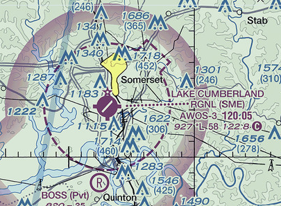
Where does the surface of the Class E airspace over Lake Cumberland Regional airport start?
At the surface

Where does Class E airspace start?
1,200’ AGL
What is the general extend of Class G airspace?
From the surface to 14,500’ MSL, and any altitude less than 1,500’ AGL above 14,500’ MSL

What kind of airspace is the Sunny one?
MOA
How is “controlled firing areas” charted on a sectional?
It isn’t charted

What kind of airspace is depicted here?
Restricted airspace

What does the “106” mean?
The length from one nav aid to another along this airway is 106nm long
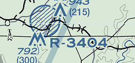
What does the dashed circle mean?
Restricted area

What is that solid blue square on the ground?
DME

What is the dotted circle around the airport?
There is an NDB at that field

What is that solid black line?
Dam
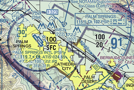
What is the gray solid lines surrounding KPSP?
TRSA

What does the circled “U” mean?
An unverified field

What does the circled “R” mean?
Restricted/Private airport

What does the circled “H” mean?
Heliport

What does the thick dashed magenta line represent?
National Security Area (NSA)
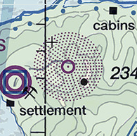
What type of nav aid is this?
Non-directional beacon (NDB)

What type of nav aid is this?
DME

What type of nav aid is this?
VOR-DME
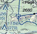
What type of nav aid is this?
VORTAC
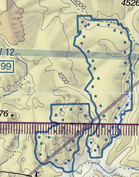
What type of airspace is the blue outlined dotted area?
Special conservation areas

What type of airspace does the blue boxed area outline?
SFRA related to national security
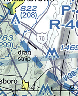
What type of airspace is the bold blue dashes?
TFR relating to national security
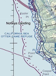
What type of airspace is the solid magenta line with magenta dots?
NOAA Regulated National Marine Sanctuary Designated Area

What type of airspace is the blue solid and boxed lines?
SFRA
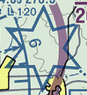
What type of airspace is the blue solid star-ish shape?
High energy radiation areas

What type of airway is this?
Miliary IFR route

What type of air routes are these?
Military VFR routes

What does this symbol represent?
Glider operations

What does this symbol represent?
Aerobatic practice area

What does this symbol mean?
Parachute jumping area with the announcement frequency

Space Launch Activity Area

What kind of airspace is in the blue hatched circle?
Prohibited area

What does this symbol mean?
Unmanned aircraft activity

What does this symbol mean?
Hang glider activity

What kind of airport is this?
Heliport
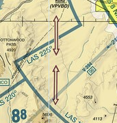
What are those magenta arrows?
Bi-directional VFR transition routes

What do these magenta arrows represent?
Uni-directional VFR transition routes

What is the dashed magenta line?
Isogonic line and value; based on five-year epoch magnetic variation model
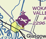
What is the star at the top of the airport symbol?
The airport has an airport beacon

What is the star in front of the “415” in the data block?
The NDB operates less than continuous or on-request

What type of nav aid is this?
NDB-DME

What does the magenta flag represent?
VFR checkpoint

Why is Popohaku Beach underlined?
It’s the name of the VFR checkpoint

Why does the airport symbol have a magenta flag on it?
It is a VFR checkpoint

What is that diamond symbol?
RNAV checkpoint