Midterm geo
 Call Kai
 Learn
Learn Practice Test
 Spaced Repetition
 Match
Match Flashcards
 Knowt Play
1/92

There's no tags or description
Looks like no tags are added yet.
Name | Mastery | Learn | Test | Matching | Spaced | Call with Kai | Chat |
|---|
No analytics yet
Send a link to your students to track their progress
93 Terms
A "lunar day":
All of these (Is theoretically the time it takes for the Earth to rotate through the two lunar tidal bulges, lasts approximately 24 hours and 50 minutes, is theoretically the time it takes for two lunar high tides and two lunar low tides to occur)
The elevation difference between high and low tides is known as:
Tidal range
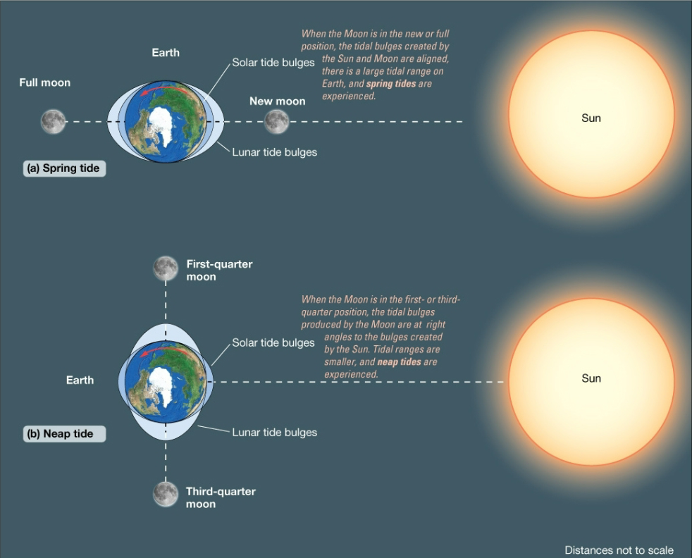
The highest tidal range occurs during:
Spring tides
The lowest tidal range occurs during:
Quadrature
Real (dynamic) tides:
All of these (Can be represented on a map using cotidal and corange lines, are influenced by seafloor bathymetry and continental configuration, propagate as forced, shallow-water waves)
In the open ocean, tidal waves rotate around _____________ points where tidal range is zero.
Amphidromic
Diurnal tides:
None of these (Consist of two equal high tides and two equal low tides per lunar day, Are characteristic of the Southern California coast, Are the most common tidal regime in the world)
Carbon dioxide:
Is linked to global warming because it is a greenhouse gas that absorbs and reradiates longwave radiation
Possible effects of anthropogenic warming on the World’s oceans include:
All of these (Changes in species distribution, Overall declines in biological productivity, Increased temperature stratification, Decreased upwelling)
Global sea level:
Is also known as eustatic sea level
Causes of eustatic sea level change include:
All of these (Tectonic movement causing changes in size and configuration of ocean basins, Expansion or contraction of sea water due to temperature change, Formation or melting of ice sheets)
Which of the following is true of local sea level?
All of these (It is rising in some places where sediment supply has been reduced, It is falling in some places that were heavily glaciated 20,000 years ago, It can be influenced by shifts in ocean circulation and temperature)
In recent years, tropical cyclones seem to have become:
Wetter
Increased coastal erosion may occur as a result of anthropogenic warming due to:
Sea level rise
During the 21st Century, the California coastline:
All of these (Is likely to experience storms causing billions of dollars in damage, Is expected to undergo widespread beach erosion, with the potential for more than 30% of beaches to disappear completely, May be influenced by changes in El Niño, atmospheric rivers, and even hurricanes)
Ocean currents are important because they influence:
All of these (Earth's climate, maritime trade routes, fisheries, pollution distribution)
Large-scale surface currents in the ocean are driven primarily by:
wind
Most deep ocean circulation originates:
in Polar oceans, where cold dense water sinks
Large scale surface circulation in the oceans includes:
None of these (two large gyres circulating counterclockwise in the Northern Hemisphere, three large gyres circulating clockwise in the Southern Hemisphere, several small Sub-Polar gyres rotating in random directions, Eastward flow around Antarctica)
Deepwater circulation in the ocean:
All of these (Is known as thermohaline circulation, is driven by density differences in seawater, has a strong influence on earth's climate)
Many species of reef coral are at risk of extinction in the 21st Century.
True
The vast, flat area lying 3000-5000 meters below the sea surface is known as the:
abyssal plain
A ___________ is a feature several thousand meters beneath the sea surface that is most commonly associated with subduction.
trench
The very gently sloping zone that extends from a few to more than a few thousand kilometers from a coastline into deeper water is known as the:
continental shelf
The steep marine zone in which turbidity currents and submarine canyons may occur is known as the:
continental slope
On leading edge coastlines:
sediment supply is often abundant, but much of it is lost into submarine canyons
Which of the following is the East Coast of the United States?
Trailing edge coast
Which of the following is most commonly associated with a narrow continental shelf and offshore trenches?
Leading edge coasts
Which of the following is most commonly associated with a wide continental shelf and depositional features?
Trailing edge coasts
Storm waves often erode sediment from the foreshore of the beach (just above the calm water level) and deposit it in a sandbar some distance offshore. This causes waves to break further offshore, reducing the impact of storm waves on the beach. This is an example of:
negative feedback
The point at which a system changes suddenly and dramatically is known as a:
threshold
The landward limit of marine influence and the seaward limit of terrestrial influence is:
a scientific definition of the coastal zone
A possible weakness of the scientific method is that:
it does not yield results that can be expressed with 100% certainty to the public and policy makers
A fundamental strength of science is that it includes mechanisms to correct its own mistakes.
True
The philosophy that the universe is fundamentally understandable through observation, theorizing, and testing describes:
science
When waves move into water that is less than ½ of their wavelength, their:
height increases
Waves in shallow water (less than 1/20th of the wavelength) move at a speed proportional only to:
water depth
The time between the passage of two successive wave crests is known as:
wave period
The circular paths of water particles that accompany propagating waves are called:
wave orbitals
________________ describes the interaction of two or more wave trains that produces much higher resultant waves, including very high, unpredictable ____________ waves in the open ocean.
Constructive interference, rogue
The three factors that determine the maximum height of wind waves that are generated are:
wind speed, wind duration, and fetch
When waves move into shallow water:
their height increases
Beaches can be found at nearly all latitudes.
True
Waves approaching a coast obliquely often produce:
longshore currents
Longshore drift:
has a net southward directly along the U.S. east and west coasts
Undertow and rip currents are best described as modes of:
cross-shore transport
Beach sediment may include:
any of these (fine sand, cobbles, pebbles, carbonates)
Beaches can best be described as:
dynamic but resilient
Natural threats to coral reef health may include:
all of these (predation by the crown of thorns starfish, ENSO events, storm waves)
The loss of zooxanthellae (algae) from corals that is often associated with increases in water temperature is called:
bleaching
Which of the following features extends from the base of the cliff to the low tide level on many rocky coastlines?
shore platforms
Which of the following is likely to be the most important cause of erosion or retreat on a consolidated clay cliff along a sheltered coastline?
slump
Which of the following is likely to be the most important cause of erosion or retreat on a granite cliff along a sub-polar coastline?
frost wedging
Which of the following is likely to be the most important cause of erosion or retreat on a limestone cliff along a tropical coastline?
chemical weathering
Stacks, arches, and shore platforms are usually associated with:
Rocky coastlines
On a complex coast, wave energy tends to be concentrated:
on headlands
Beach compartments include:
all of the above (a sediment source, such as a river, beaches where sediment is (temporarily) deposited, submarine canyons, where sediment is deposited offshore)
Storm waves tend to cause:
sand to be eroded from the beach face and deposited as an offshore bar
During stormy "winter" conditions, beaches:
Develop longshore bars
Wind transport often occurs as a series of short hops or jumps in ____________, which is known as _____________.
dunes, saltation
Vegetation often enhances the growth of _____________ by capturing wind-blown sediment.
dunes
The distribution of life in the oceans is influenced by:
All of the above (Light availability, Temperature, Dissolved gases)
Photosynthesis in the oceans occurs only in the:
Euphotic zone
The conversion of inorganic compounds to organic matter by organisms is known as:
Primary Production
The diverse mix of organisms that float in the oceans without the ability to swim against currents is known as:
Plankton
The class of organisms that live on the seabed is known as:
Benthos
Chemosynthesis in the oceans:
All the above (Is most common near hydrothermal vents and cold seeps, Accounts for an unknown, but potentially very significant portion of overall primary production, Is most important at depths where insufficient light is available for photosynthesis)
Sediment nourishment (replenishment):
All of these (often involves moving sediment from inlets or offshore sources onto the beach, can be prohibitively expensive, is considered a "soft stabilization" strategy)
Stone structures built in shallow water parallel to the shore in order to reduce incoming wave energy are known as:
Breakwaters
Structures built perpendicular to the shoreline to protect inlets from sediment deposition and incoming wave energy are known as:
Jetties
A sedimentary feature connecting an island or structure to the mainland is known as a:
tombolo
Extremely long, narrow sedimentary features that formed along much of the United States East Coast and Gulf Coast as a result of sea level rise are called:
barrier islands
Over time, most barrier islands:
migrate landward as a result of overwash, particularly during storms
Strategies for dune protection and nourishment include:
All of these (Planting vegetation, Erecting dune fencing, Restricting people from walking on dunes)
Construction restrictions and relocation of structures in coastal zones:
Can be expensive and controversial
Seawalls:
All of these (Are primarily used to protect coastal infrastructure, Disrupt the natural movement of sediments in a coastal system, May lead to sediment loss on beaches)
An increased rate of chemical weathering of rock resulting from a warmer climate can remove carbon dioxide from the atmosphere, potentially reducing global temperature. However, this is unlikely to reduce the current rate of sea level rise because:
the time scale of the chemical weathering process is too long (i.e., slow)
Storm waves often erode sediment from the foreshore of the beach (just above the calm water level) and deposit it in a sandbar some distance offshore. This causes waves to break further offshore, reducing the impact of storm waves on the beach. This is an example of:
negative feedback
The seasonal shift in wave climate and beach profile shape best illustrates:
meta-stable equilibrium
Briefly discuss how the scientific method works. Does this method yield answers with 100% certainty? How is this both a strength and a weakness?
Observation, question, research, hypothesize, experiment, test hypothesis, draw conclusions, report,
Will not yeild answers with 100% certainty
It can be repeatable to check the same facts and findings
It is able to check its own mistakes
It can create human bias and a desire to prove a specific point
It is a slow process and is not always 100% and results can always change therefore, policies can change as well
Define positive and negative feedback and provide examples. Outline the reasons that positive feedback is usually considered bad
Negative feedback is a counteractive response to a change within the system in order to bring it back to a stable point
Ex: increase in carbon dioxide, causes increase in atmospheric temp, increase in vegetation growth, increase the capture of CO2 by plants, decrease of CO2 and atmospheric temp
Positive feedback increases the magnitude of the initial change, destabilizing the system and pulls it away from equilibrium
EX. decrease in temp, increase of ice formation, increase in Albedo, decrease in energy absorption, decrease of temp
Define the following bathymetric features of the ocean: a) trench b) abyssal plain c) mid-ocean ridge
d) continental margin. Provide a range of depths and a mode of formation where possible.
Trenches: the deepest parts of the ocean, occupy a small area along the convergent boundaries (depth of 7-11km)
Most common around the pacific ring of fire
Subductions zones
Abyssal plain: deep flat expanses that occupy the majority of the ocean floor (depth of 4-6 km)
Suspension settling of very fine sediment that covers the ocean crust irregularities
Mid-ocean ridge: submarine mountain range along the divergent boundaries (depth less than 3 km)
In areas of new crust creation due to eruption of basaltic lava
Continental margins: shallow areas close to shore; inculdes continental shelf, slope, and rise
In areas of transtions between continents and the deep ocea
Describe two causes of upwelling and discuss why upwelling is important.
Causes: the wind and the Earth’s rotation/the Coriolis effect (deflection that occurs as a result of the Earth’s rotation)
Importance: brings nutrient-rich water to the surface, allowing high biological productivity in the food web. Supports the majority of global fisheries
Use a diagram to show the characteristics of deep-water waves. On your diagram, show the following: a) crest b) trough c) still water level d) wave orbitals e) wavelength f) wave height g) wave base.

Discuss how the following factors change as waves enter shallow water: a) wave height b) wave speed (celerity) c) wavelength d) wave steepness e) wave period
height: decrease, speed: decreases, wavelength: decreases, steepness: increases, period: remains constant
Use diagrams to illustrate the difference between summer (fair weather) and winter (storm) beach profiles

Discuss three “hard stabilization” strategies on coasts and identify at least one disadvantage of each
Groins and groin fields
A rocky structure that is built perpendicular to the beach
Main goal is to trap sand upcoast
Cons: causes downdrift erosion, erosion downcoast
Jetties
A structure built in pairs perpendicular to shore on either side of an inlet
Primary purpose is to protect harbor entrance
Cons: causes downdrift erosion, erosion downcoast
Breakwaters
A rocky structure that is built parallel to the shoreline
Used to protect harbors from waves but occasionally used on open-coast beaches
Con: causes excessive erosion, requires dredging to keep area stable
Seawalls
Built on landward side of a beach to armor coastlines and protect human developments
Con: needs constant repair, disrupts natural patterns of sediment, causing beaches to be less resilient
Discuss three “soft stabilization” strategies on coasts and identify at least one disadvantage of each
Beach replacement/Nourishment
Adding sand to the beach/ dunes
Cons: it's expensive, imported sand, may cause changes in sand characteristics (new toxins or materials)
Construction restrictions
Limit building near shorelines
Cons: National Flood Insurance Program encourages construction; building codes can be adapted to make infrastructure more resilient (they’re gonna build it anyways)
Reolcation
Make people move out of coastal places to let the beach repair itself or let it process
Move structures/buildings rather than protect them
Cons: coastal residents hate it (don't wanna move), expensive
Define a) Neuston b) plankton c) nekton and d) benthos. Provide an example of each
• Neuston: live on the water surface (sometimes grouped with plankton)
Ex: zooplankton, microzooplankton, duckweed
• Plankton: lifeforms suspended in the water column that cannot swim against currents
Ex: zooplankton, holoplankton, krill
• Nekton: lifeforms suspended in the water column that can swim against currents
Ex: fish, squids, crabs, bony fish
• Benthos: live on the seabed
Ex: macroalgae, red algae, brown algae, seagrass
Define physical and chemical weathering. Discuss which type is most likely to be important on different types of rocky coastlines based on factors such as climate and geography.
Physical: disintegration of rock into smaller pieces with no change in chemical composition
(summary): Does well with soft rock, dominates in cold temps
Most notable at places with soft rocks (has joints, cracks, bedding planes, other weaknesses), large variation in temp, high winds, waves, and/or streamflows
Chemical: breakdown as a result of chemical reactions
(summary): does well with reactive rocks, dominates in warm temps
Include hydration, hydrolysis, carbonation, oxidation, and dissolution
Rate typically increases with increases in temperature, moisture availability, and acidity (decrease in pH)
Discuss how global warming is influencing the following: a) biological productivity and the distribution of species in the oceans b) stream runoff and coastal sediment supply c) wave energy
Biological productivity
Decrease in upwelling = decrease bio productivity (lack of phytoplankton)
Increased ocean stratification and stronger thermocline
Several past extinction events have been linked to ocean warming and stratification
Sea creatures are relocating to waters that match their normal conditions
Stream runoff
Due to an increase in storms and high waves, it causes long-term sediment loss
Increase in rainfall and flooding causes more erosion to natural structures
Wave energy
Stronger higher waves
Increase in wave energy
What is global (eustatic) sea level change, and what are two causes?
The increase of global sea level (+3.6 mm/yr)
1) Melting of Greenland and Antarctic Ice Sheets, along with alpine glaciers
2) Thermal expansion of surface and deep water
Use a diagram to illustrate the position of the earth, moon, and sun during spring tides and neap tides