GEO 2104 - Ethics in GIS
 Call Kai
 Learn
 Practice Test
 Spaced Repetition
 Match
 Flashcards
 Knowt Play
1/11

There's no tags or description
Looks like no tags are added yet.
12 Terms
Why Ethics in GIS? (3)
Data produced can used to invade privacy
These data are used to inform policy decisions
GIS technology has potential to exacerbate societal inequities
Areas of Application of Ethics in GIS (3)
Collection
Analysis
Visualization
Areas of Application: Collection & Analysis (3)
Research or crowdsourced?
Clean data of Personally Identifiable Information (PII) before analysis/sharing
What of security sensitive data? Keep data secure
Areas of Application: Visualization (4 points, 2 examples)
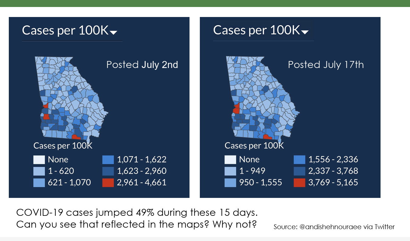
Maps can inform but also deceive
Deceptive maps have existed for ages and hide critical information (e.g. propaganda maps, trap maps, etc.)
Maps need to show the appropriate information for the reader to make an informed decision
Inappropriate maps/graphics lead to misunderstanding
What other factors should you consider? (Necessary to standardize data?)
Population?
Geographic area?
Color choice for features impact perception
Red = bad/dire/severe
Green = good/better/preferred
Darker tones = more
Lighter tones = less
Official Standards?
There is no official standard for the geospatial industry; the ethics need to evolve with the industry
Establishment of Guidelines/Codes (3 overall examples)
1) Professional/Industry Organizations
Geospatial Professional Network (GPN)
American Society for Photogrammetry and Remote Sensing (ASPRS)
GIS Certification Institute (GISP)
2) United Nations Children’s Fund (UNICEF)
Focuses on how geo tech are used to protect vulnerable populations
3) American Geographical Society (AGS) – EthicalGEO (5 Priorities)
Privacy
Politics
People
Planet
Property
Code of Ethics: 10 Key Attributes by Spatial Reserves
1. Maps should be evident, not deceptive or confusing
2. Know your audience – facilitates effective communication
3. Do not lie with your data
4. Show all relevant data as completely as possible
5. Do not discard contradictory data, remain neutral in your portrayal of data
6. Portray your data accurately, do not exaggerate or diminish
7. No plagiarism
8. Choose neutral symbols to minimize bias
9. Repeatability of your work – someone else can replicate it
10. Sensitivity to cultural values & beliefs
Joseph Kerski Quote
“…when creating a map, you should strive to provide a truthful, neutral representation of reality targeted specifically for your audiences’ level of knowledge so that your map can effectively convey your intended message.”
Placenames & Propaganda
Gulf of America, West Taiwan, Canada Everywhere, etc.
GIS Professional Ethics Project: Guide to Ethical Decision-Making (Workplace Dilemmas)
1. State the problem
Does it make you uncomfortable?
Is there a conflict of interest?
2. Check facts — some issues disappear with closer examination, others look very different
3. Identify relevant factors
Who’s involved?
What laws, professional code of conduct apply?
4. Develop list of options
Whom to go to
What to say
Possible scenarios
5. Review & Test Options
Harm — Is one choice > < than another?
Publicity — Ok with it being public?
Defensibility — In front of peers?
Reversibility — What if it impacted me how it would others?
Colleague, Professional & Organization tests — Talk to them all
6. Make choice based on 1-5
7. Review steps 1-6 to determine how to avoid this situation in the future
Case Study 1: Ethical Evaluation of Remote Sensing in Conservation
TBD 1
Case Study 2: Practical Application of the GIS Code of Ethics
TBD 2