Part 1 Exam: Geology of National Parks
0.0(0)
Studied by 0 people Call Kai
 Learn
Learn Practice Test
 Spaced Repetition
 Match
Match Flashcards
 Knowt Play
Card Sorting
1/116

Earn XP
Description and Tags
117 Terms
1
New cards
Which of the following national parks IS NOT found in the Colorado Plateaus physiographic province:
a. Zion NP
b. Grand Canyon NP
c. Great Sand Dunes NP
d. Capitol Reef NP
a. Zion NP
b. Grand Canyon NP
c. Great Sand Dunes NP
d. Capitol Reef NP
2
New cards
The dominant agent of erosion shaping the land surface in the Colorado Plateaus is:
a. wind
b. running water
c. earthquakes
d. slumping
a. wind
b. running water
c. earthquakes
d. slumping
3
New cards
Which of the following is (are) a characteristic of the Colorado Pleateaus:
a. flat-lying sedimentary rocks
b. relatively high elevations (5-11 thousand feet)
c. semiarid climate
d. all of the above
a. flat-lying sedimentary rocks
b. relatively high elevations (5-11 thousand feet)
c. semiarid climate
d. all of the above
4
New cards
Which of the following is NOT associated with relative ages of rocks.
a. interpretation of rock layers
b. fossils
c. study of ancient life forms
d. radioactive decay of rocks
a. interpretation of rock layers
b. fossils
c. study of ancient life forms
d. radioactive decay of rocks
5
New cards
Which of the following sedimentary rocks are found in the Colorado Plateaus?
a. limestone
b. sandstone
c. shale
d. All of the above
a. limestone
b. sandstone
c. shale
d. All of the above
6
New cards
Which type of rock (s) are exposed in the Inner Gorge of the Grand Canyon?
a. igneous
b. metamorphic
c. sedimentary
d. Both A & B above
a. igneous
b. metamorphic
c. sedimentary
d. Both A & B above
7
New cards
A coarse textured sedimentary rock is?
a. shale
b. siltstone
c. granite
d. conglomerate
a. shale
b. siltstone
c. granite
d. conglomerate
8
New cards
Which of the following would be considered a clastic sedimentary rock?
a. shale
b. sandstone
c. conglomerate
d. All of the above
a. shale
b. sandstone
c. conglomerate
d. All of the above
9
New cards
A time gap in the geologic record of rocks is called?
a. monocline
b. syncline
c. unconformity
d. None of the above
a. monocline
b. syncline
c. unconformity
d. None of the above
10
New cards
An upfold in sedimentary rocks is called a: anticline
a. syncline
b. monocline
c. isocline
d. None of the above
a. syncline
b. monocline
c. isocline
d. None of the above
11
New cards
Movement along a break or fracture in bedrock causing displacement is called?
a. angular unconformity
b. isocline
c. fault
d. None of the above
a. angular unconformity
b. isocline
c. fault
d. None of the above
12
New cards
This is a type of igneous volcanic rock formation in which hot magma from inside the earth flows out onto the surface.
a. extrusive
b. intrusive
c. platonic
d. None of the above
a. extrusive
b. intrusive
c. platonic
d. None of the above
13
New cards
This is a downward-curving fold with layers that dip toward the center.
a. monocline
b. syncline
c. anticline
d. exocline
a. monocline
b. syncline
c. anticline
d. exocline
14
New cards
This occurs when the forces responsible for sediment transportation are no longer strong enough to overcome the forces of particle weight and friction.
a. weathering
b. headward erosion
c. deposition
d. None of the above
a. weathering
b. headward erosion
c. deposition
d. None of the above
15
New cards
Which of the following IS NOT found in Zion National Park
a. Virgin River
b. Kolob Arch
c. Vishnu schist
d. Navajo Sandstone
a. Virgin River
b. Kolob Arch
c. Vishnu schist
d. Navajo Sandstone
16
New cards
Which of the following processes have been responsible for the remarkable scenery found in Bryce Canyon National Park?
a. weathering
b. slope wash
c. mass wasting
d. All of the above
a. weathering
b. slope wash
c. mass wasting
d. All of the above
17
New cards
Which of the following IS NOT a chemical weathering process?
a. oxidation
b. hydration
c. carbonation
d. exfoliation
a. oxidation
b. hydration
c. carbonation
d. exfoliation
18
New cards
Which of the following is a prominent feature in Bryce Canyon National Park?
a. hoodoos
b. stream terrace
c. Vishnu schist
d. None of the above
a. hoodoos
b. stream terrace
c. Vishnu schist
d. None of the above
19
New cards
The Water Pocket Fold is found in: Capitol Reef
a. Grand Canyon National Park
b. Zion National Park
c. Bryce Canyon National Park
d. None of the above
a. Grand Canyon National Park
b. Zion National Park
c. Bryce Canyon National Park
d. None of the above
20
New cards
The Water Pocket Fold is a:
a. syncline
b. anticline
c. monocline
d. None of the above
a. syncline
b. anticline
c. monocline
d. None of the above
21
New cards
Which of the following is (are) an example of mass wasting that operates in arid regions.
a. rockslides
b. mudflows
c. debris slides
d. All of the above
a. rockslides
b. mudflows
c. debris slides
d. All of the above
22
New cards
The Hickman Natural Bridge is found in:
a. Zion National Park
b. Capitol Reef National Park
c. Bryce Canyon National Park
d. Natural Bridges National Monument
a. Zion National Park
b. Capitol Reef National Park
c. Bryce Canyon National Park
d. Natural Bridges National Monument
23
New cards
Rock tanks or potholes are a prominent feature in:
a. Zion National Park
b. Bryce Canyon National Park
c. Grand Canyon National Park
d. Capitol Reef National Park
a. Zion National Park
b. Bryce Canyon National Park
c. Grand Canyon National Park
d. Capitol Reef National Park
24
New cards
The confluence of the Green and Colorado Rivers is found in: Canyonlands
a. Grand Canyon National Park
b. Bryce Canyon National Park
c. Zion National Park
d. None of the above
a. Grand Canyon National Park
b. Bryce Canyon National Park
c. Zion National Park
d. None of the above
25
New cards
Which of these geologically distinctive areas is found in Canyonlands National Park?
a. maze
b. needles
c. island in the sky
d. All of the above
a. maze
b. needles
c. island in the sky
d. All of the above
26
New cards
Which of the following processes play a role in the development of natural arches?
a. forming of deep vertical, parallel fractures
b. formation of fins
c. frost action and weathering
d. All of the above
a. forming of deep vertical, parallel fractures
b. formation of fins
c. frost action and weathering
d. All of the above
27
New cards
Probably the most well-known arch that is unique in its isolation and can be found on the Utah license plate is:
a. Double Arch
b. Delicate Arch
c. Kolob Arch
d. Landscape Arch
a. Double Arch
b. Delicate Arch
c. Kolob Arch
d. Landscape Arch
28
New cards
Salt anticlines played an important role in the formation of:
a. Arches National Park
b. Bryce Canyon National Park
c. Zion National Park
d. None of the above
a. Arches National Park
b. Bryce Canyon National Park
c. Zion National Park
d. None of the above
29
New cards
This rock formation is famous for its many fossils (including dinosaurs) and its uranium deposits:
a. Morrison Formation
b. Navajo Sandstone Formation
c. Entrada Sandstone Formation
d. None of the above
a. Morrison Formation
b. Navajo Sandstone Formation
c. Entrada Sandstone Formation
d. None of the above
30
New cards
Although this national park has an interesting geology it is primarily noted for its Pre-Columbian cliff dwellings, multi-room Pueblos, and ancient irrigation systems.
a. Arches National Park
b. Canyonlands National Park
c. Mesa Verde National Park
d. Bryce Canyon National
a. Arches National Park
b. Canyonlands National Park
c. Mesa Verde National Park
d. Bryce Canyon National
31
New cards
The ability of a rock formation to hold large amounts of water is called:
a. permeability
b. porosity
c. loess
d. None of the above
a. permeability
b. porosity
c. loess
d. None of the above
32
New cards
The ability of rock to let water move through it easily is called:
a. permeability
b. porosity
c. loess
d. None of the above
a. permeability
b. porosity
c. loess
d. None of the above
33
New cards
A ridge that slopes gently on one side but has a steep scarp or cliff on the opposite side is called a:
a. Mesa
b. Cuesta
c. Butte
d. None of the above
a. Mesa
b. Cuesta
c. Butte
d. None of the above
34
New cards
A desert surface that is covered with closely packed, interlocking angular or round rock fragments is called:
a. desert varnish
b. desert pavement
c. caliche
d. None of the above
a. desert varnish
b. desert pavement
c. caliche
d. None of the above
35
New cards
A hardened deposit of soluble calcium salts such as calcium carbonate found in desert areas is called:
a. caliche
b. desert pavement
c. desert varnish
d. All of the above
a. caliche
b. desert pavement
c. desert varnish
d. All of the above
36
New cards
When organic cells decompose and are replaced by minerals you get:
a. jasperoio
b. petrified wood
c. caliche
d. None of the above
a. jasperoio
b. petrified wood
c. caliche
d. None of the above
37
New cards
This is a type of arid landscape where softer sedimentary rock and clay-rich soils have been extensively eroded by water and wind.
a. desert varnish
b. petroglyphs
c. desert pavement
d. badlands
a. desert varnish
b. petroglyphs
c. desert pavement
d. badlands
38
New cards
These are the preserved remains or traces of animals, plants or other organisms from the remote past.
a. cratons
b. fossils
c. paleosols
d. None of the above
a. cratons
b. fossils
c. paleosols
d. None of the above
39
New cards
This park or region probably has the richest storehouse of vertebrate fossils in all of North America.
a. Mesa Verde National Park
b. Petrified Forest National Park
c. Badlands National Park
d. Arches National Park
a. Mesa Verde National Park
b. Petrified Forest National Park
c. Badlands National Park
d. Arches National Park
40
New cards
Which of the following is true about the Great Plains?
a. it overlays the North American craton
b. it is primarily composed of sedimentary rocks
c. it has a regional tilt, higher in the West
d. All of the above
a. it overlays the North American craton
b. it is primarily composed of sedimentary rocks
c. it has a regional tilt, higher in the West
d. All of the above
41
New cards
An erosional escarpment that acts as a drainage divide in Badlands National Park is called:
a. The Craton
b. The Savanna
c. The Steppe
d. The Wall
a. The Craton
b. The Savanna
c. The Steppe
d. The Wall
42
New cards
Some of the highest current rates of erosion in the world are found in:
a. Mesa Verde National Park
b. Badlands National Park
c. Petrified Forest National Park
d. Colorado National Monument
a. Mesa Verde National Park
b. Badlands National Park
c. Petrified Forest National Park
d. Colorado National Monument
43
New cards
When sediments fill cracks and fissures in sedimentary rocks and then are cemented together into hard resistant rock they can form:
a. paleosols
b. piping
c. clastic dikes
d. None of the above
a. paleosols
b. piping
c. clastic dikes
d. None of the above
44
New cards
Which of the following would be considered fluvial landforms?
a. sandbars
b. oxbows
c. cutbanks
d. All of the above
a. sandbars
b. oxbows
c. cutbanks
d. All of the above
45
New cards
Which of the following would NOT be considered a permafrost feature?
a. ice-wedges
b. pingoes
c. polygons
d. barchans
a. ice-wedges
b. pingoes
c. polygons
d. barchans
46
New cards
A sand dune that is half-moon shaped in map view with the arms printing downwind is called:
a. blowout
b. parabolic
c. barchan
d. None of the above
a. blowout
b. parabolic
c. barchan
d. None of the above
47
New cards
Low ridges of sand that parallel the riverbanks and are deposited by the river during flooding are called?
a. cutbank
b. point bar
c. natural levee
d. None of the above
a. cutbank
b. point bar
c. natural levee
d. None of the above
48
New cards
The tallest sand dunes in North America are found in:
a. Kobuk Valley National Park
b. Great Sand Dunes National Park
c. Death Valley National Park
d. None of the above
a. Kobuk Valley National Park
b. Great Sand Dunes National Park
c. Death Valley National Park
d. None of the above
49
New cards
This national park is located in Colorado’s San Luis Valley. Great Sand Dunes NP
a. Rocky Mountain National Park
b. Gunnison National Park
c. Colorado National Park
d. None of the above
a. Rocky Mountain National Park
b. Gunnison National Park
c. Colorado National Park
d. None of the above
50
New cards
This type of stream is divided into an interlacing network with the individual streamlets being separated by channel sandbars.
a. surging stream
b. oxbow stream
c. braided stream
d. None of the above
a. surging stream
b. oxbow stream
c. braided stream
d. None of the above
51
New cards
T/F: Mass wasting is the downslope movement of material under gravity.
52
New cards
T/F: Wind is the most powerful geologic agent in humid climates.
53
New cards
T/F: The determination of ABSOLUTE AGES of rocks is based on Paleontology (study of ancient life forms) and stratigraphy (interpretation of rock layers).
54
New cards
T/F: ”Layer-cake Geology” is primarily associated with flat-lying sedimentary rocks.
55
New cards
T/F: The red color of rocks in the Colorado Pleateaus is primarily due to the presence of minute amounts of iron compounds.
56
New cards
T/F: Much of the sediment load that used to scour the Grand Canyon during spring floods now settles to the bottom of Lake Powell behind the Glen Canyon Dam.
57
New cards
T/F: Sea level is the ultimate base level for the Colorado River.
58
New cards
T/F: Much of the sediment load that used to scour the Grand Canyon during spring floods now settles to the bottom of Lake Powell behind the Glen Canyon Dam.
59
New cards
T/F: A stream with a low gradient has a great deal of erosive power.
60
New cards
T/F: The oldest rocks in the Grand Canyon are the Vishnu schists.
61
New cards
T/F: The three main types of rocks are igneous, sedimentary and metamorphic.
62
New cards
T/F: The most common sedimentary rock having a nonclastic texture is limestone.
63
New cards
T/F: Compression of layered rocks can create an upfold called a syncline.
64
New cards
T/F: In a normal fault the hanging wall side of the fault moves down in relation to the footwall side.
65
New cards
T/F: In a strike-slip fault one side of the fault moves horizontally by the other side.
66
New cards
T/F: In the Grand Canyon shales tend to be cliff-formers, while limestones form gentle slopes.
67
New cards
T/F: The narrow inner gorge of the Grand Canyon is not terraced or stepped because the rocks there have fairly uniform hardness and are more resistant to erosion.
68
New cards
T/F: A tributary valley with the floor at a higher relief than the main channel into which it flows is called a hanging valley..
69
New cards
T/F: An underwater mountain range, typically having a valley known as a rift running along its spine and formed by plate tectonics is called a Mid-ocean ridge.
70
New cards
T/F: The essential idea of plate tectonics states that the earth’s outer shell consists of twelve or more major crustal plates, and about a dozen smaller ones.
71
New cards
T/F: The downward trickling of running water, not in channels, is called slope wash.
72
New cards
T/F: The pink hues of the beds in Bryce Canyon are due to the presence of iron oxide and manganese in the rocks.
73
New cards
T/F: The stripping of concentric rock slabs from the outer surface of a resistant rock mass is called exfoliation
74
New cards
T/F: Rock weathering involves physical and chemical processes that occur independently from each other.
75
New cards
T/F: Angular rock faces are more common in humid areas than in arid regions.
76
New cards
T/F: An intermittent stream is a stream that is temporary or seasonal.
77
New cards
T/F: A natural bridge is primarily formed by physical and chemical weathering plus mass wasting.
78
New cards
T/F: Natural arches may form from fins.
79
New cards
T/F: The greatest density of natural arches in the world is found in Arches National Park.
80
New cards
T/F:Most of the soil on the mesa top at Mesa Verde National Park is the result of accumulated wind-deposited silt called loess.
81
New cards
T/F: Differential weathering and erosion has uncovered the petrified logs, which are more resistant to erosion than the rock formation in which they are buried.
82
New cards
T/F: As sandstone weathers in a desert climate, a thin dark brownish red or black patina called desert varnish may develop on the rock surface.
83
New cards
T/F: Petroglyphs are images created by removing part of a rock surface by incising or carving. This can occur in desert varnish and is often associated with prehistoric peoples.
84
New cards
T/F: A craton is a portion of the earth’s crust that has been stable for a long time.
85
New cards
T/F: Badlands National Park has many different paleosols which can be seen as reddish bands in the landscape.
86
New cards
T/F: Topographic position (north or south facing slopes) has little effect on the landscape in Badlands National Park.
87
New cards
T/F: Most of the bedrock in Kobuk Valley National Park is found very close to the surface.
88
New cards
T/F:The natural flow patterns of some rivers tend to create sweeping curves, bends, and loops called meanders.
89
New cards
T/F: The Rio Grande River runs through the San Luis Valley in Colorado.
90
New cards
T/F: Most of the sand at Great Sand Dunes National Park was originally derived from rocks of the San Juan Mountains.
91
New cards
Matching:
A. Grand Canyon National Park
B . Zion National Park
C. Bryce Canyon National Park
D. Canyonlands National Park
E. Mesa Verde National Park
F. Great Sand Dunes National Park
\
a. Sevier River
b. Rio Grande River
c. Colorado River
d. Mancos River
e. Green River
f. Virgin River
A. Grand Canyon National Park
B . Zion National Park
C. Bryce Canyon National Park
D. Canyonlands National Park
E. Mesa Verde National Park
F. Great Sand Dunes National Park
\
a. Sevier River
b. Rio Grande River
c. Colorado River
d. Mancos River
e. Green River
f. Virgin River
92
New cards
Matching:
A. Zion National Park
B. Bryce Canyon National Park
C. Arches National Park
D. Petrified Forest National Park
\
a. Navajo Sandstone Formation
b. Claron Formation
c. Chinle Formation
d. Entrada Sandstone Formation
A. Zion National Park
B. Bryce Canyon National Park
C. Arches National Park
D. Petrified Forest National Park
\
a. Navajo Sandstone Formation
b. Claron Formation
c. Chinle Formation
d. Entrada Sandstone Formation
93
New cards
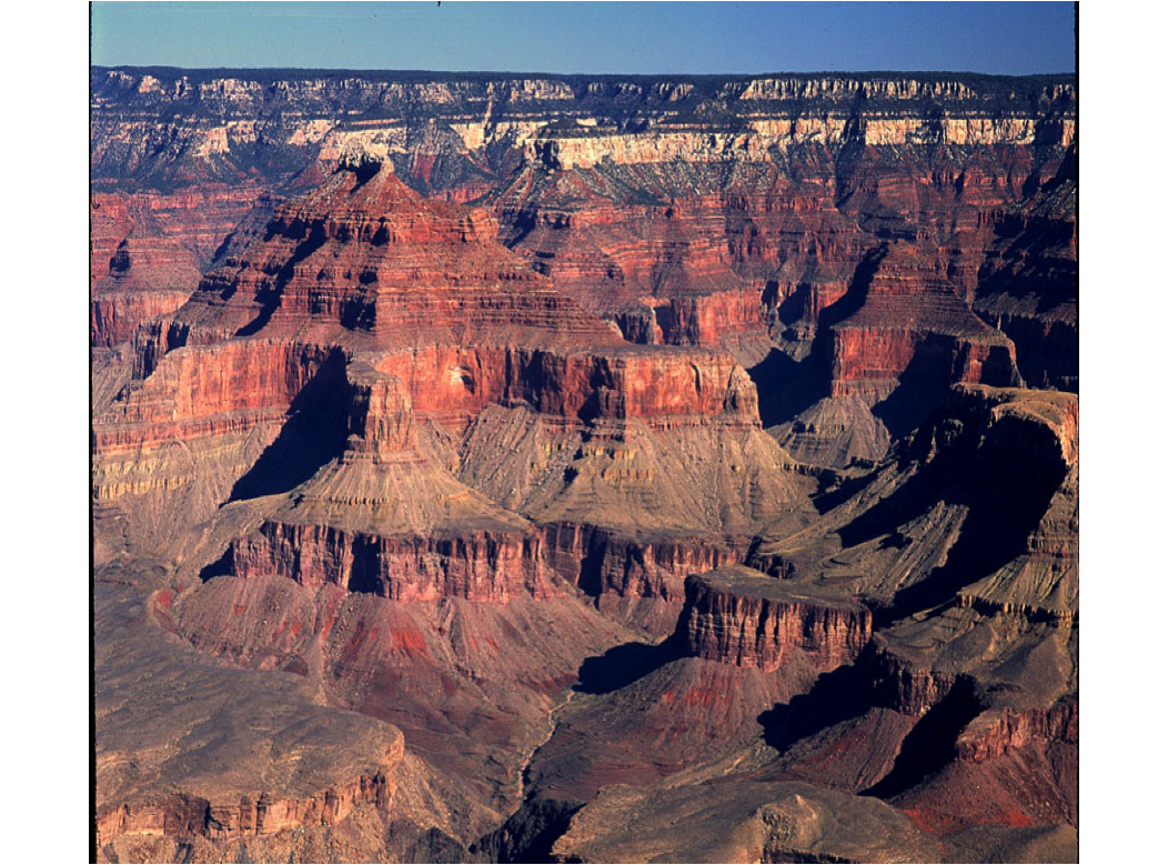
This photo of the Grand Canyon is a good illustration of :
a. faulting
b. folding
c. stairstep /layer-cake Geology
d. None of the above
a. faulting
b. folding
c. stairstep /layer-cake Geology
d. None of the above
c. stairstep /layer-cake Geology
94
New cards
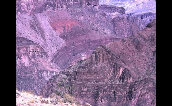
This photo of the bottom of the Grand Canyon shows the oldest rock called:
a. Navajo sandstone
b. Vishnu Schist
c. Morrisson Formation
d. None of the above
a. Navajo sandstone
b. Vishnu Schist
c. Morrisson Formation
d. None of the above
b. Vishnu Schist
95
New cards
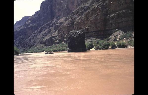
The red color of the Colorado River is due to:
a. iron compounds
b. saline water
c. artesian water
d. None of the above
a. iron compounds
b. saline water
c. artesian water
d. None of the above
a. iron compounds
96
New cards
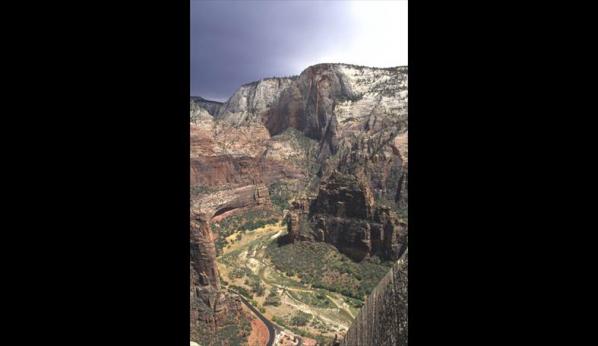
The creation of Zion Canyon is the result of:
a. downcutting
b. weathering
c. mass wasting
d. All of the above
a. downcutting
b. weathering
c. mass wasting
d. All of the above
d. All of the above
97
New cards
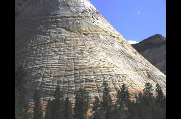
The Checkerboard Mesa in Zion National Park is a good example of:
a. karst topography
b. solution weathering
c. cross-bedding
d. None of the above
a. karst topography
b. solution weathering
c. cross-bedding
d. None of the above
c. cross-bedding
98
New cards
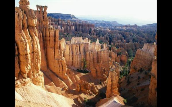
This photo was taken in:
a. Grand Canyon National Park
b. Zion National Park
c. Capitol Reef National Park
d. None of the above
a. Grand Canyon National Park
b. Zion National Park
c. Capitol Reef National Park
d. None of the above
d. None of the above, Bryce Canyon
99
New cards
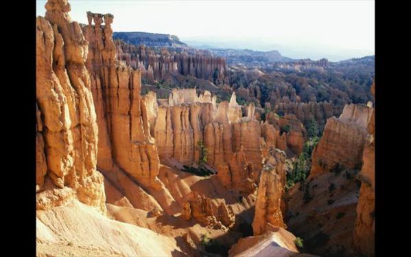
This photo shows an erosional formation called a:
a. hoodoo
b. unconformity
c. pothole
d. None of the above
a. hoodoo
b. unconformity
c. pothole
d. None of the above
a. hoodoo
100
New cards
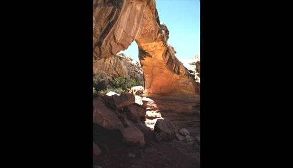
Hickman natural bridge is found in:
a. Bryce Canyon National Park
b. Zion National Park
c. Capitol Reef National Park
d. None of the above
a. Bryce Canyon National Park
b. Zion National Park
c. Capitol Reef National Park
d. None of the above
c. Capitol Reef National Park