IFR Low-Enroute Chart Symbols
 Call Kai
 Learn
 Practice Test
 Spaced Repetition
 Match
 Flashcards
 Knowt Play
1/35

There's no tags or description
Looks like no tags are added yet.
36 Terms

What is this symbol?
MEA - Minimum En Route Altitude
Obstacle clearance & ensures navigation signal coverage.

What is this symbol?
RNAV Minimum En Route Altitude
Allows a lower MEA for using a GPS since it is more accurate.

What is this symbol?
MRA - Minimum Reception Altitude
Minimum altitude where navigational signal can be received for the route or off-course NAVAID facilities.

What is this symbol?
MAA - Maximum Authorized Altitude
Maximum published altitude for the airspace or route. Adequate reception of NAV signals is assured.
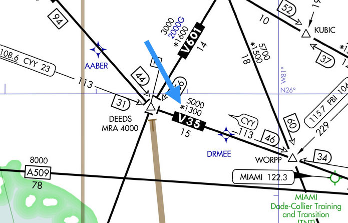
What is this symbol?
MOCA - Minimum Obstruction Clearance Altitude
Meets obstacle clearance requirements and assures navigational signal coverage only within 22NM of VOR.

What is this symbol?
ORORCA - Off Route Obstruction Clearance Altitude
Provides obstruction clearance (mountainous/non-mountainous). Doesn’t guarantee signal coverage from NAVAIDs, ATC radar or communications.

What is this symbol?
MTA - Minimum Turning Altitude
Provides obstruction clearance over fixes, waypoints and route segments. Anticipate the turn and flyover protection is assured.

What is this symbol?
MCA - Minimum Crossing Altitude
Lowest altitude to cross before proceeding to a higher en route IFR minimum.

What is this symbol?
Radial Degree
Sole purpose is to ensure pilot’s don’t misread the radial. Now you know you’re looking at the 90° radial and not the 60° radial.

What is this symbol?
Stand-Alone AWOS/ASOS Weather Station
Not attached to an airport. Helps pick up weather information.

What is this symbol?
Helicopter RNAV (routes) TK Routes
Used for helicopters having IFR-approved GPS & GNSS equipment.

What is this symbol?
Crossing Altitudes by compass direction.
The MCA is 8,400 MSL when flying south.

What is this symbol?
MEA Gap
You could lose ground-based navigational coverage along this V134 route.
You see an MEA that says 12000’ while flying East. Which altitude should you fly at?
Since the flight is Eastbound, we’ll need odds thousands altitudes, so 13,000’ is appropriate.

What area of the map is this?
MOA - Military Operations Area

What does this black flag mean?
MCA - Minimum Crossing Altitude
You need to cross at a minimum altitude of 7,000’ MSL on V338 when going NE.

You're contacting flight service on 122.1. What frequency will you hear them on?
122.1 R = receiving-only frequency
Transmit to FS on 122.1 , but you’ll hear FS on 110.8

You're making an emergency diversion into Asheville Regional airport. How long is the longest runway?
80 = 8,000’

Why is this VORTAC filled in with black?
It’s a compulsory reporting point.

What do gray zig-zags mean on a chart?
The route segment is not usable.
What does an (A) & (A)* symbolize in Airport Information?
(A) = ATIS frequency
(A)* = may mean part-time.

Why does the Concorde VOR have a (T) next to its name?
(T) means it's a Terminal VOR
Service Volume: 1,000' - 3,000' & radial distance of 25NM.
What is a Fly-by Waypoint?
What is a Fly-over Waypoint?
Fly-by: requires a turn anticipation to remain on track (no circle).
Fly-over: must fly over the point then initial turn (circled).

Why might a pilot need to observe a Maximum Authorized Altitude (MAA) published on a low enroute route segment?
To prevent the aircraft's navigation receiver from picking up conflicting signals from off-course or overlapping VOR stations from the same frequency operating further away.
What does the S symbolize on this approach chart?
Straight in minimums to Rwy 36


What do these symbols mean?
Lighting Available
Pilot Controlled Lighting

Lighting Capability - what do these symbols mean?
Top Star - Part Time or on Request
No Star - No lighting available

What is this Symbol?
DME - Distance Measuring Equipment
Filled means it’s a Compulsory Reporting Point

What is this Symbol?
Compass Locator Beacon
Can be used for tracking, or identifying fixes along an approach or transition.
15NM radius.

What is this symbol?
ILS Localizer Course
With additional navigation function.

What is this symbol?
Radio Communications Outlet (RCO) Frequency.
Single Frequency.

What is this symbol?
Stand Alone Flight Service Station
T = transmit only
R = receive only

Victor Airway.

Uncontrolled LF/MF airway.
A low-altitude federal airway based on low- and medium- frequency ground navigation aids (NDBs/Radio Ranges).

RNAV T Route
1200' AGL - Up to but not including 18,000' MSL
Low level RNAV/GPS route.

Distance Measuring Equipment (DME) Fix
Denotes DME fix (encircled mileage shown when not otherwise obvious)