Flight Rules and Plane Parts
 Call Kai
 Learn
 Practice Test
 Spaced Repetition
 Match
 Flashcards
 Knowt Play
1/66

There's no tags or description
Looks like no tags are added yet.
67 Terms
Controlled Airspace
Anywhere where ATC services can be provided
MSL vs AGL
Mean sea level - altitude from sea level.
At ground level - altitude from the ground elevation
Class A airspace
from 18,000’MSL - 60,000’MSL(FL600)
plane must be under IFR

Class B airspace
for largest and busiest airports
Surface - 10,000’ MSL two ore more layers in upside-down cake
ATC clearance is required to enter, must have transponder

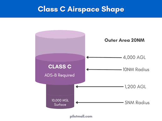
Class C airspace
moderately busy airports with control towers
Surface - 4,000’ AGL
Two layers: lower is 5 NM Radius, upper is 10 NM
must establish two-way with ATC to enter
Class D airspace
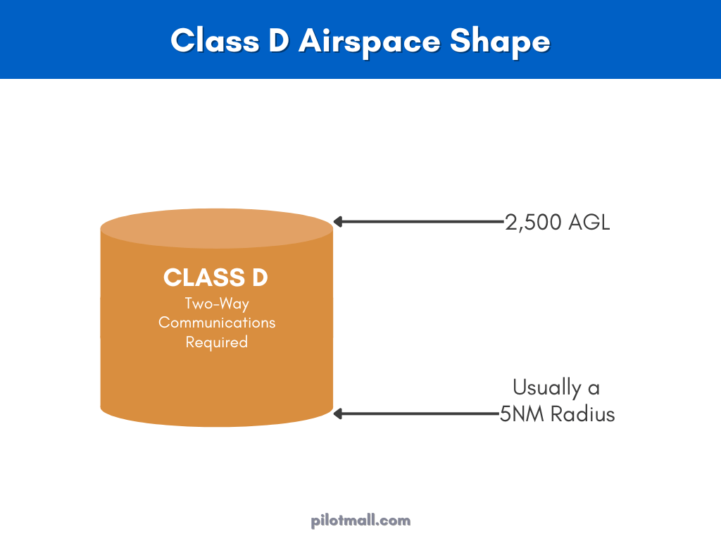
Least congested airports with control towers
surface to 2,500’ AGL
Two-way ATC communication to enter
Class E airspace
Controlled airspace that isn’t A-D
Extends up to but not including 18,000MSL
Class G airspace
uncontrolled, no ATC services provided, surface to base of class E
VFR rules apply
Special Use Airspace
Prohibited area
Restricted area
Warning area
Military operation area (MOAs)
Alert Area
Controlled firing area (CFAs')
the 4 airspeed types
Indicated airspeed (IAS) - Uncalibrated airspeed from the difference between the two pressure sensors - calibrated to knots of indicated airspeed (KIAS)
Calibrated airspeed (CAS) - IAS but corrected for instrumentation errors
True airspeed (TAS) - The actual velocity of the plane, corrected for the difference in air density at altitude - equal to IAS at sea level
Ground speed (GS) - Aircrafts speed over the ground - adding or subtracting the winds effect of hte plane - modern planes use GPS to calculate
How does an aircraft measure airspeed
Pitot tube - measures total air pressure while flying and compares it to a static air pressure sensor
Static Ports - holes on the fuselage that measure static pressure of the environment
Nautical Mile (NM)
1/60 degree of latitude
1.1508 statute miles (sm)
1.852 kilometers (km)
Headings
The direction the aircraft is travelling. Crosswinds can affect heading
Course
The actual direction the aircraft is heading
True Course vs Magnetic course
True Course is heading in relation to the geographical north pole
Magnetic Course where the compass points - changes year to year
NAVAIDS
Navigation Aids
VOR: Omni-directional beacon
VOR/DME: Omni-directional beacon with distance measuring equipment
TACAN: Military Version of VOR/DME
VFR
Visual Flight Rules - minimal communication with ATC
Pilot is responsible for avoiding other aircraft and other obstructions
VFR Weather Minimums
VFR - ceiling greater than 3,000’ and visibility over 5 miles - sky clear
MVFR - Ceiling 1,000’ - 3,000’ and/or visibility 3-5 miles
IFR(instrument flight rules) - Ceiling 500 - less than 1,000’ and/or visibility 1 to less than 3 miles
LIFR - Ceiling less than 500 feet and/or visibility less than 1 mile
Cloud Clearance requirements
Class A: VFR aircraft are not allowed to operate in class A airspace. - IFR only
Class B: 3 mile visibility minimum and remain clear of clouds
Class C,D,E(Below 10,000’ MSL): 3 mile visibility and remain 500’ below, 1000’ above and 2000’ laterally of clouds
Class E (Above 10,000’ MSL): 5 mile visibility, 1000’ below and above and 1 mile horizontally of clouds
VFR Cruising altitudes
N/a when below 3000’ AGL
Based on MC - fly at 1000’ + 500’ intervals
0° - 179° ODD 1000’s
180° - 360° EVEN 1000’s
What speed are aircraft limited to below 10,000 feet MSL?
250 KIAS
What speed are aircraft limited to in veils of Class B airspace
200 KIAS
IFR
Instrument Flight rules
Constant communication with ATC
Used when weather dictates and in Class A airspace
Need an instrument rating
IFR Cruising Altitudes
Based on MC - 1000’ intervals
0° - 179° ODD
180° - 360° EVEN
Troposphere
Lowest level of atmosphere - has weather, temp drops 2° every 1000’ - height changes depending on latitude, top is 7-10 km, and lower latitudes are 17-18 km high
Stratosphere
Begins after the troposphere, up to about 50km
Temps begin to rise because of ozone
Mesosphere
temps and ozone decrease
After the stratosphere
Thermosphere and Ionosphere
temps begin to rise again
Solar radiation ionizes particles
Exosphere
top of atmosphere, extends to up to 500km, mainly oxygen and hydrogen atoms
What is the order of the atmosphere
Troposphere
Stratosphere
Mesosphere
Thermosphere
Exosphere
What lights are used at the edge of the Taxiway
Blue lights mark the edge
At larger airports green lights are placed on centerline
What lights mark a runway
White lights mark edge
Green lights indicate threshold
Red lights mark the end of the runway
What are the two systems for approach inidcators
PAPI - Precision approach path indicator
VASI - Visual approach slope indicator
How does the PAPI system work
Horizontal lights to indicate if slope is correct
equal red and white is on path
if below there are more reds than white
if above more whites than reds
How does the VASI system work
A square of four lights
equal white and red is on slope
more red than white is low
more white than red is above
Rotating Beacons
Civilian airports flash white and green
military airfields flash white twice and green once
What lights mark a water airport
Flashing white and yellow lights on a rotating beacon
What lights mark a heliport
flighting white, yellow, and green lights on rotating beacon

What sign is this
Runway hold position sign
Signifies that a runway is ahead and the two numbers are the runways ahead
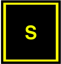
What sign is this
Taxiway location sign

What sign is this
Taxiway direction sign - arrow points in direction of taxiway

What sign is this
Direction sign array - combination of taxiway location sign and direction sign
What does yellow and white paint mean
White paint is for runways
Yellow paint is for taxiways
Steady Green Light - from airport
Ground - Cleared for Takeoff
Air - Cleared for Landing
Flashing Green light - from airport
Ground - cleared to Taxi
Air- Return for Landing - followed by steady green
Steady Red - from airport
Ground - STOP
Air - Give way and continue circling
Flashing Red - from airport
Ground - taxi clear of runway in use
Air - Airport unsafe don’t land
Flashing White - from airport
Ground - return to starting point
Air- N/A
Alternating Red/Green - from airport
All - exercise extreme caution
Plane powerplant types
Piston - prop aircraft; carburetor can ice at lower temps and high humidity
Turboprop - constant-speed engines; use variable pitch to control speed
Turbojet - compresses air and adds fuel; lower fuel efficiency at subsonic speeds; high-velocity exhaust
Turbofan - Front fan derives a majority of thrust, high bypass ratio so higher efficiency and more thrust at higher altitudes
High bypass vs Low bypass
Most military aircraft use low bypass turbofans because of high thrust and compact size
Commercial aircraft use high bypass
Parasite drag
The drag not associated with lift production
Three kinds: Form, interference, skin friction
Form Drag
generated from moving an object through the air, how quickly air is split and rejoins
Interference Drag
Intersection of airstreams, when two surfaces meet at perpendicular agnles
Skin Friction Drag
drag from air contacting surface of aircraft
Induced Drag
Air that flows from below the wing to the low pressure system on the top of the wing tips - rotational energy on wing tips
Torque Reaction
Newtons 3rd law - prop moves counter clockwise plane with have a left turning tendency
Corkscrewing
Spiraling air around fuselage runs against the vertical stabilizer, left-turning tendency if prop is clockwise
P-Factor
When pitched upwards, the thrust produced by the downward blade is higher - left turning factor
What are the Four controls that separate rotary-wing aircraft from fixed wing aircraft
Cyclic
Collective
Anti-Toque Pedals
Cyclic
Changes the pitch of the main rotor blades to control the attitude of the rotor disk
Changes the lift direction to control pitch and roll
Directly in front of the pilot
Collective
Next to pilot seat and controls lift, moving up increases lift and down causes less lift
anti-torque pedals
Similar to rudder petals - control tail rotor blade