Chart Symbols- 1
 Call Kai
 Learn
Learn Practice Test
 Spaced Repetition
 Match
Match Flashcards
 Knowt Play
1/60

There's no tags or description
Looks like no tags are added yet.
Name | Mastery | Learn | Test | Matching | Spaced | Call with Kai | Chat |
|---|
No analytics yet
Send a link to your students to track their progress
61 Terms
Civil airport that does NOT have a published instrument approach precedure.

Civil Airport with approved instrument approach procedures and Radar Minimums.

Pilot Controlled Lighting

Civil airport with an Instrument Approach Procedure and/or RADAR MINIMA published in the high altitude DoD Flight Information Publications (FLIPs)

VOR/DME (Non Compulsory Reporting or Off Airway)

Off-set arrows indicate facility forming a fix - Arrow points away from the VHF/UHF NAVAID

Lighting available--In operation sunrise to sunset.

Part-time or On-request

Mileage Breakdown or Computer Navigation Fix (CNF). A five letter identifier in parentheses indicates CNF with no ATC function.

victor airway

Off Route Obstruction Clearance Altitude (OROCA) Example: 10, 100 feet

minimum speed: depicted as a number with a line below it

VOR

A Fix with non-compulsory position reporting

VOR with compulsory position reporting

ILS Localizer Course with additional navigation function.

Minimum Crossing Altitude or Minimum Turning Altitude.

Victor Airway

RNAV Waypoint, compulsory position reporting

Unusable Route Segment

DME Fix (encircled mileage shown when not otherwise obvious.)

Total Mileage between Compulsory Fixes or NAVAIDS

MILEAGE BETWEEN OTHER FIXES, NAVAIDs AND/OR MILEAGE BREAKDOWN

Minimum Reception Altitude (MRA)

altitude change MEA (minimum enroute altitude), MOCA(minimum obstacle clearance altitude) and/or MAA (minimum authorized altitude) --at other than NAVAID

Changeover Point. Point where changeover from NAVAIDs occurs. Millage to NAVAIDs shown. (This is not shown at midpoints)

Minimum Enroute Altitude (MEA)

Minimum Obstruction Clearance Altitude (MOCA)

Mandatory altitude (cross at)

Minimum altitude (cross at or above)

Max Altitude (Cross at or below)

RNAV WAYPOINTS Non-Compulsory Position Reporting

ASOS/AWOS (VHF/UHF) -

VORTAC

shoreline

NDB- UHF Nondirectional radio Beacon
Non-compulsory reporting
Compulsory reporting

Stand Alone Flight Service Station.

Civil and Military Airport, with an approved Instrument Approach Procedure and/or RADAR MINIMA published in either the FAA Terminal Procedures Publication or the DoD FLIPs

Air Route Traffic Control Center (ARTCC) Boundary

RNAV T-Route

Military Operations Area (MOA)

Class B Airspace

Military Training Route (MTR)

Heliports that have an Instrument Approach Procedure and/or RADAR MINIMA published at least in the High Altitude DoD FLIPs

PREFERRED SINGLE DIRECTION VICTOR ROUTE

Stand Alone Remote Communications Outlet (RCO)

Missed Approach Holding Pattern

RADIAL OUTBOUND FROM A VHF/UHF NAVAID
All Radials are magnetic

VHF/UHF Compass Rose
Compass Roses are orientated to Magnetic North of the NAVAID which may not be adjusted to the charted isogonic values.

Canada Danger Area
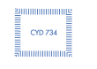
Preferred single Direction RNAV Q route

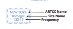
ARTCC Remoted Sites with
discrete VHF and UHF frequencies
Represents an uncontrolled LF/MF airway

Special Flight Rules Area (SFRA)

Holding Pattern

Class C Airspace

An entry is published in the Takeoff Minimums, (Obstacle) Departure Procedures, and Diverse Vector Area (Radar Vectors) section of the TPP.

A cold temperature altitude correction is required at that airport when the reported temperature is at or below the published temperature

WAAS (Wide Area Augmentation System). The negative within a black square box symbol shown in the Notes section below any "A" or "T" Symbol indicates that outages of the WAAS (Wide Area Augmentation System) vertical guidance may occur daily at this location due to initial system limitations. WAAS NOTAMs for vertical outages are not provided for this approach. Use LNAV minima for flight planning at these locations, whether as a destination or alternate. For flight operations at these locations, when the WAAS avionics indicate that LNAV/VNAV or LPV service is available, then vertical guidance may be used to complete the approach using the displayed level of service. Should an outage occur during the procedure, reversion to LNAV minima may be required.

Alternate minimums are not authorized due to unmonitored facility or absence of weather reporting service.

Non-standard IFR alternate minimums exist. Refer to IFR Alternate Airport Minimums section of the TPP.
