Learn: Environmental Geomatics Test #2 Review
 Call Kai
 Learn
 Practice Test
 Spaced Repetition
 Match
 Flashcards
 Knowt Play
1/41

There's no tags or description
Looks like no tags are added yet.
42 Terms
Querying
identifying or retrieving specific information from a dataset
Measurement
determining the value of a particular attribute such as distance, area, or count
Descriptive Summary
summarizing patterns or characteristics of data without making predictions or identifying causes
Optimization
finding the best solution from a set of possible options based on certain criteria
Modeling
using data & assumptions to predict future outcomes or phenomena
Spatial Question
a question that specifies the location, distribution, or arrangement of features in space (consider where things occur, how they are arranged in relation to other things, or how patterns change across place)
SQL (Structured Query Language)
SELECT * FROM table name WHERE: condition
Spatial Relationships
specifies how some object is located in space in relation to some reference object
A feature _________ another if any part of it overlaps or otuches that feature.
intersect (A,B, & C)

To _________ means shares at least a single point at the boundary with the other feature, but does not completely overlap.
touch (A & B)

When two features have a common segment (not just a point), they ________ a line segment.
share (B)
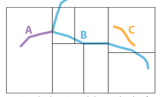
One feature is ________ _________ another if its whole geometry falls inside.
contained within (A & C)

Requires _____ ______ or all parts of the selecting object are inside the other object without touching the boundary or outside.
complete containment (C)

Dissolving Operation
merges adjacent features in a vector dataset that share the same attribute value for the chosen disolve field, resulting in few, larger features

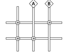
Nodes
a point where two or more lines (such as roads or streams) meet or intersect
Planarize
where spatial netowrk (like roads or lines) are transformed so that all line crossings are treated as true intersects (crossing between A & B only takes 2 if all was planarized, while using nodes takes 4)
Clip Operation
used to extract the features of one layer (input layer) that fall within the boundary of another layer (clip layer)

Union Operation
combines two datasets (input layers) to produce a new layer that includes all the features from both datasets

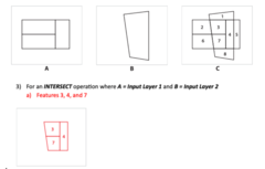
Intersect Operation
produces a new layer containing only those features (or portions of features) that are shared between two input datasets (spatial area where both layers overlap_
Erase Operation
removes areas from an input dataset that overlap with another dataset called the erase layer

Identity Operation
where features from the input layer are kept, but portions that overlap with a second layer (identity layer) absorb geometry & attributes from both layers

Update Operation
used to replace geometry & attributes of features in one dataset (input layer) with those from another dataset (update layer) whenever they overlap
OR Operator (|)
the output cell is set to 1 if at least one of the input rasters has a value of 1 for that call (true), otherwise the output is 0 if false

AND Operator (&)
the output cell is set to 1 only if both input rasters have a value of 1 for that cell (true), otherwise is 0 if false

Focal Mean
neighborhood operation that involves computing the average (mean) value within a specified neighborhood around each cell in raster dataset

Global Minimum
assigns the smallest value found anywhere in the entire raster to every cell in the output raster

Zonal Maxium
where each output cell is assigned the highest value found in its corresponding "zone" as defined by a zone raster or layer

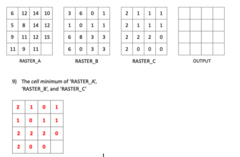
Cell Minimum
smallest input value for each cell acroos rasters
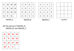
Cell Sum
sum of input values for each cell across rasters
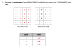
Zonal Mean
a summary operation where each "zone" is assigned the average (mean) value of another input raster for all cells belonging to that zone
Elevation
measures the height above a reference point (usually sea level)
Slope
gives the angle of change in elevation at the position of each cell

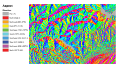
Aspect
the compass direction a slope faces (ex: north, south, east, west)
Cut-&-Fill
quantifies volumes of earth to be removed (cut) or added (fill) the landscape's shape

Viewshed
shows all of the areas that are visible in all directions

Density Analysis
calculates how cloesly points, lines, or events are clustered together in space (usually within a specified area or around a set location)
Spatial Interpolation
a process of estimating unknown values at unsampled locations based on values measured at known sample points
Edge Effects
refers to problems that occur when estimating values near or beyond the outer boundary of the area covered by measured sample points in spatial interpolation
Nearest Neighbor Interpolation
spatial interpolation method where the value assigned to each raster cell is the same as the value of the closet measured sample point to that cell
Buffering
creates a zone around a spatial feature (point, line, or polygon) at a specified distance (helps identify aras within or outside distance from the feature)

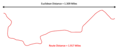
Euclidean Distance
calculates the straight-line distance betwen two feature or locations, without regard to obstacles or paths

Linear Referencing
measures distance along a linear feature (like a road, river, or train track), not a straight line