PPL Exam 2 Review
 Call Kai
 Learn
 Practice Test
 Spaced Repetition
 Match
 Flashcards
 Knowt Play
1/227

There's no tags or description
Looks like no tags are added yet.
228 Terms
If the outside air temperature (OAT) at a given altitude is warmer than standard, the density altitude is
higher than pressure altitude
Which combination of atmospheric conditions will reduce aircraft takeoff and climb performance?
High temperature, high relative humidity, and high density altitude

(Refer to Figure 8.) What is the effect of a temperature increase from 25 to 50°F on the density altitude if the pressure altitude remains at 5,000 feet?
1,650-foot increase.

(Refer to Figure 8.) Determine the pressure altitude with an indicated altitude of 1,380 feet MSL with an altimeter setting of 28.22 (Hg) at standard temperature.
2,991 ft MSL
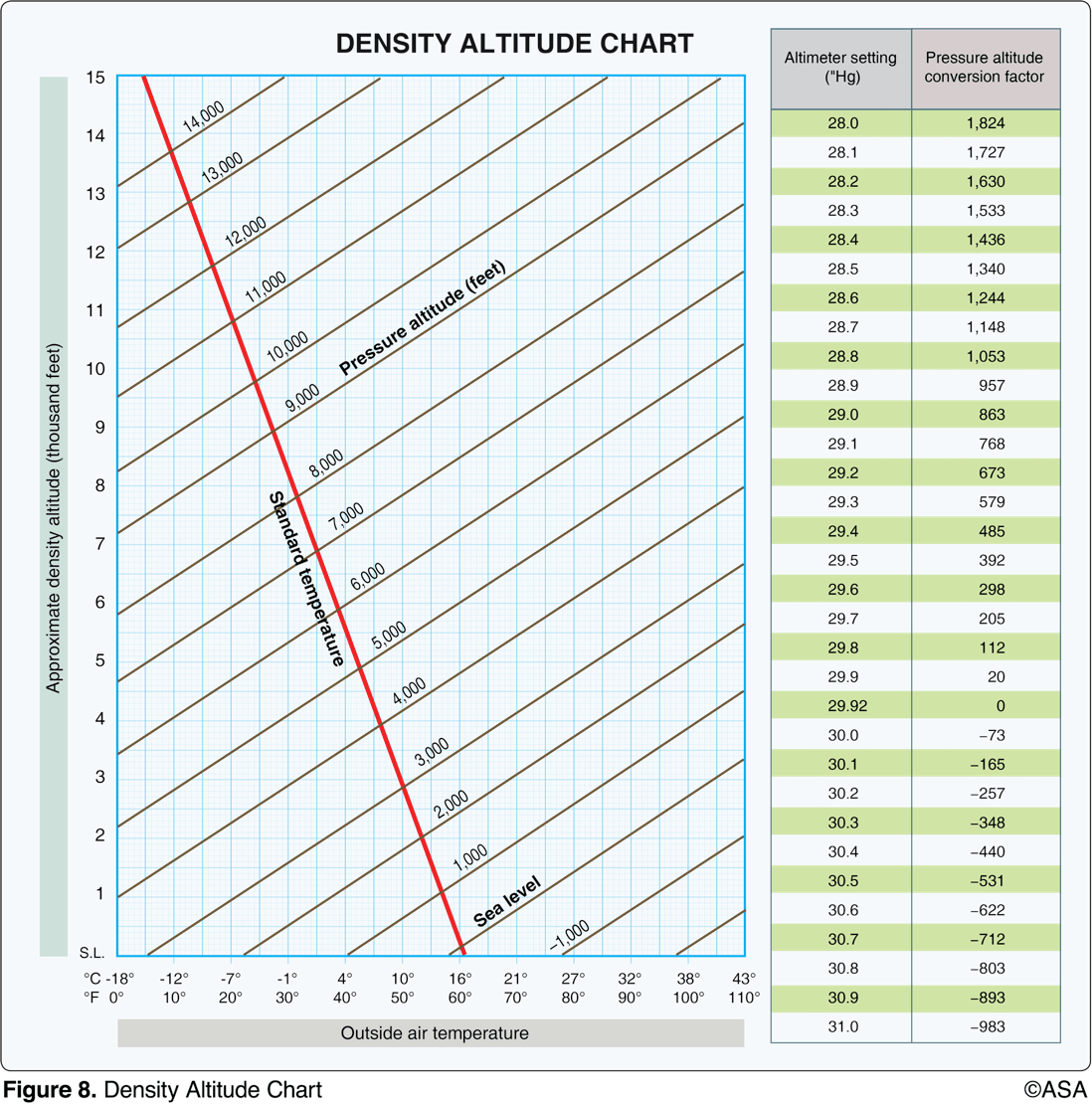
(Refer to Figure 8.) Determine the density altitude for these conditions:
Altimeter setting: 29.25
Runway temperature: + 80°F
Airport elevation: 5,250 ft MSL
8,500 ft MSL
What effect, if any, does high humidity have on aircraft performance?
It decreases performance
What are the standard temperature and pressure values for sea level?
15*C (59*F) and 29.92’’Hg (1013.2 MBHg)
Which factor would tend to increase the density altitude at a given airport?
An increase in ambient temperature
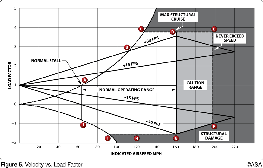
What does the horizontal dashed line from Point C to Point E represent?
positive limit load factor
True or False? A POH can be approved by the FAA as an approved Flight Manual for an airplane.
True
What is the approximate temperature lapse rate?
2*C per 1000’
If the operational category of an airplane is listed as "utility", this means the airplane could be operated in which maneuvers?
Limited aerobatics, including spins
What is the standard temperature at 10,000 feet?
-5*C
What is the standard temperature at 20,000 feet?
-25*C
List the ARROW documents.
Airworthiness Certificate, Registration Certificate, Radio Station License (international flights only), Operating Handbook, Weight and Balance documents
Define the Never-Exceed Speed (Vne).
the absolute maximum speed at which the airplane may be flown, indicated by red line on AI
Which weather conditions should be expected beneath a low-level temperature inversion layer when the relative humidity is high?
Smooth air, poor visibility, fog, haze, or low clouds.
Which conditions result in the formation of frost?
The temperature of the collecting surface is at or below the dewpoint of the adjacent air and the dewpoint is below freezing.
What cloud types would indicate convective turbulence?
Towering cumulus clouds
Possible mountain wave turbulence could be anticipated when winds of 40 knots or greater blow
across a mountain ridge, and the air is stable.
Where does wind shear occur?
At all altitudes, in all directions
When may hazardous wind shear be expected?
In areas of low-level temperature inversion, frontal zones, and clear air turbulence.
One in-flight condition necessary for structural icing to form is
visible moisture
In which environment is aircraft structural ice most likely to have the highest accumulation rate?
freezing rain
Why is frost considered hazardous to flight?
Frost spoils the smooth flow of air over the wings, thereby decreasing lifting capability.
How does frost affect the lifting surfaces of an airplane on takeoff?
Frost may prevent the airplane from becoming airborne at normal takeoff speed.
If there is thunderstorm activity in the vicinity of an airport at which you plan to land, which hazardous atmospheric phenomenon might be expected on the landing approach?
Wind-shear turbulence.
Upon encountering severe turbulence, which flight condition should the pilot attempt to maintain?
Level flight attitude
What situation is most conducive to the formation of radiation fog?
Warm, moist air over low, flatland areas on clear, calm nights.
If the temperature/dewpoint spread is small and decreasing, and the temperature is 62°F, what type weather is most likely to develop?
Fog or low clouds.
In which situation is advection fog most likely to form?
An air mass moving inland from the coast in winter.
What types of fog depend upon wind in order to exist?
Advection fog and upslope fog.
There are three primary reasons structural icing is extremely hazardous. Name two.
Increase in weight, Adverse aerodynamic effects, Controllability
Which control in the flight deck is used to protect you against carburetor icing?
Carburetor Heat
Which instruments are likely to give you faulty indications if ice has formed over the static vents? ____,____ ,_____
VSI, Airspeed indicator, altimeter
True or False? The outside air temperature does not need to be below freezing for carburetor icing to occur.
True
What is smog
smog is the combo of fog and smoke
What are the differences between civilian and military airport beacons?
Civilian - Green & White
Military - Green & 2 White
What is the minimum altitude and clearance over a congested area?
1000’ above surface, 2000’ horizontal
What is the minimum altitude over an uncongested area?
500’ above surface
What does it mean if a runway is designated 32L or 32R?
Left or right parallel runways
What is the rule for VFR cruising altitudes regarding direction of flight?
000-179: odd thousands + 500'
180-359: even thousands + 500'
Which is the correct traffic pattern departure procedure to use at a noncontrolled airport?
Comply with any FAA traffic pattern established for the airport.
The recommended entry position to an airport traffic pattern is
to enter 45° at the midpoint of the downwind leg at traffic pattern altitude.

What is the length of the displaced threshold for runway 22 at Toledo Executive (TDZ)?
380 feet.
An airport's rotating beacon operated during daylight hours indicates
that weather at the airport located in Class D airspace is below basic VFR weather minimums.
The numbers 9 and 27 on a runway indicate that the runway is oriented approximately
090° and 270° magnetic.

What frequency is the ATIS at Lincoln Municipal Airport (LNK) on?
118.05
Who should not participate in the Land and Hold Short Operations (LAHSO) program?
student pilots
While operating in Class D airspace, each pilot of an aircraft approaching to land on a runway served by a visual approach slope indicator (VASI) shall
maintain an altitude at or above the glide slope until a lower altitude is necessary for a safe landing.

Where in relation to the airfield is the airport beacon located for Sioux City (SUX) airport?
East of runway 17-35.
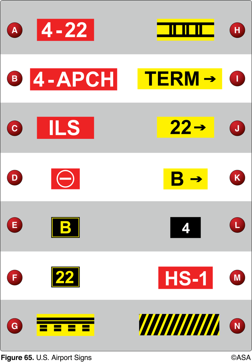
From the cockpit, marking G confirms the aircraft to be
on a runway, about to clear.

How long and wide is Runway 18 at Lincoln Municipal Airport (LNK)?
12901’, 200’
What color are taxiway centerline lights?
green
What does a steady green light signal directed from the control tower to you while on the ground indicate?
You are cleared for takeoff.
In order for an airport to be considered a Commercial Service Airport, it must be publicly owned and have at least _______ passenger boardings per calendar year, and receive scheduled passenger service.
2500
What is the definition of a Reliever Airport?
A reliever airport is an airport close to a busy commercial airport that takes some traffic away from it.
For Class "A" Airspace, state the basic VFR visibility and distance from clouds minimums.
Visibility: NOT APPLICABLE
Distance from clouds: NOT APPLICABLE
For Class "B" Airspace, state the basic VFR visibility and distance from clouds minimums.
Visibility: 3SM
Distance from clouds: Clear of Clouds
For Class "C" Airspace, state the basic VFR visibility and distance from clouds minimums.
Visibility: 3SM
Distance from clouds: 500' below, 1000' above, 2000' horizontal
For Class "D" Airspace, state the basic VFR visibility and distance from clouds minimums.
Visibility: 3SM
Distance from clouds: 500' below, 1000' above, 2000' horizontal
For Class "E" Airspace, state the basic VFR visibility and distance from clouds minimums.At or Above 10,000 Feet MSL
Visibility: 3SM
Distance from clouds: 500' below, 1000' above, 2000' horizontal
For Class "E" Airspace, state the basic VFR visibility and distance from clouds minimums.At or Below 10,000 Feet MSL
Visibility: 3SM
Distance 1000 feet above, 500 feet below, 2000 feet horizontal
For Class "G" Airspace, state the basic VFR visibility and distance from clouds minimums. 1,200' or less AGL Day
Visibility: 1SM
Distance from clouds: Clear of clouds
For Class "G" Airspace, state the basic VFR visibility and distance from clouds minimums. 1,200' or less AGL Night
Visibility: 3SM
Distance from clouds: 500' Below, 1000' Above, 2000' Horizontal
For Class "G" Airspace, state the basic VFR visibility and distance from clouds minimums. More than 1,200' AGL but less than 10,000' MSL Day
Visibility: 1SM
Distance from clouds: 500' Below, 1000' Above, 2000' Horizontal
For Class "G" Airspace, state the basic VFR visibility and distance from clouds minimums. More than 1,200' AGL but less than 10,000' MSL Night
Visibility: 3SM
Distance from clouds: 500' Below, 1000' Above, 2000' Horizontal
For Class "G" Airspace, state the basic VFR visibility and distance from clouds minimums. More than 1,200' AGL and at/above 10,000' MSL
Visibility: 5SM
Distance from clouds: 1000' below, 1000 above, 1 SM
The Prime Meridian is ___ degrees of Longitude and runs through _______________ .
0, Greenwich, England
Where would a pilot find information about a Military Operations Area (MOA) such as Altitude of Use, Time of Use, and Controlling Agency?
A pilot can find information about an MOA at the back of a sectional chart.

(Refer to Figure 71, area 4) For information about the parachute jumping operations at Lincoln Regional/ Harder (LHM) Airport, refer to
the Chart Supplements U.S. (formerly Airport/Facility Directory).

(Refer to Figure 69.) What minimum equipment is required for a flight from Kleberg Co. Airport (area 7) to Corpus Christi Intl. Airport (area 3)?
Two-way radio and Mode C transponder with altitude reporting equipment.

Unless otherwise specified, Federal Airways include that Class E airspace extending upward from
1,200 feet above the surface up to and including 17,999 feet MSL.

(Refer to figure 20, area 1.) The NALF Fentress (NFE) Airport is in what type of airspace?
Class E.
A blue segmented circle on a Sectional Chart depicts which class airspace?
Class D.
In which type of airspace are VFR flights prohibited?
Class A.
True or False? The plane of a great circle passes through the center of the earth.
true
What effect does high density altitude have on aircraft performance?
It reduces climb performance.
When turbulence is encountered during the approach to landing, what action is recommended and for what primary reason?
Increase the airspeed slightly above normal approach speed to attain more positive control.
Higher gross weights will not affect climb performance. True or False?
False
Where would you expect to find the greatest friction effect between the terrain and the wind?
rough terrain
The horizontal motion of air is known as?
advection
What is meant by the term 'dewpoint'?
The temperature to which air must be cooled to become saturated
Clouds, fog, or dew will always form when
water vapor condenses
What are the processes by which moisture is added to unsaturated air?
Evaporation and sublimation
What is a characteristic of stable air?
Stratiform clouds
What are characteristics of unstable air?
Turbulence and good surface visibility
The suffix 'nimbus,' used in naming clouds, means
Rain cloud
Steady precipitation preceding a front is an indication of
stratiform clouds with little or no turbulence.
What conditions are necessary for the formation of thunderstorms?
High humidity, lifting force, and unstable conditions.
What airspeed should you fly when encountering turbulent conditions?
Va or Vb
If you cannot avoid a thunderstorm and are forced to fly through it, what should you do?
Allow airspeed to fluctuate and avoid rapid power changes
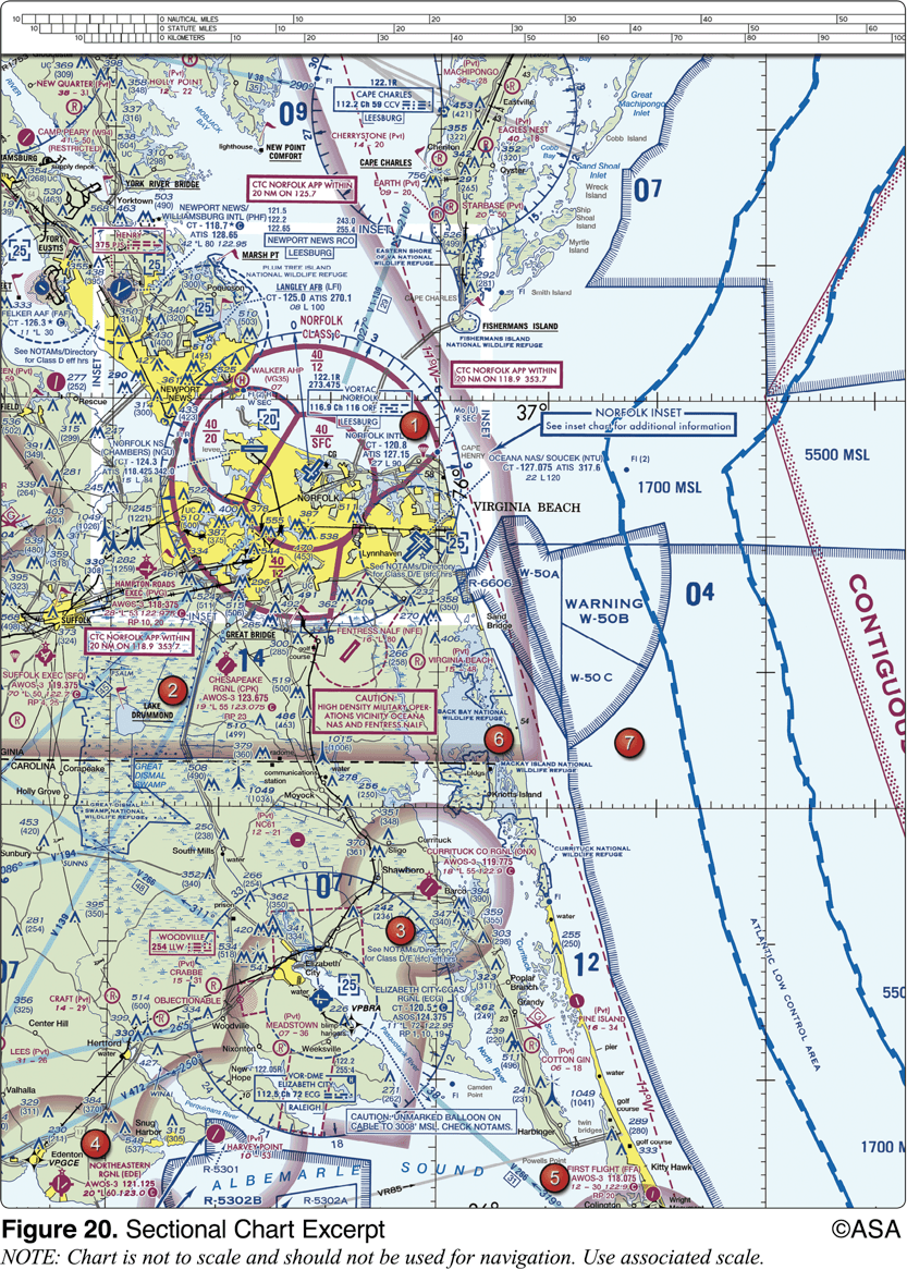
(Refer to Figure 59, area 3.) The airspace directly overlying the town of Findlay is
Surface area Class E airspace.
What actions do we take if we're converging head-to-head with another aircraft?
Both pilots would turn right.
What actions do we take if we're converging at an angle with another aircraft?
The aircraft on right has the right-of-way and other aircraft must move to the right to avoid a collision.
Emergency Aircraft
Same category - aircraft on the right has right of way
Different category - less maneuverable aircraft has right of way
"BuGTAAR"
What actions do we take if we're overtaking another aircraft from the rear?
When overtaking another aircraft, you would pass to the right.
What does the outbound destination sign identify?
Identifies direction to take-off runways.

(Refer to Figure 75, west of Area 6.) During preflight planning, your course is plotted to fly through R-2305. Where would you find additional information regarding this airspace?
On the Sectional Chart in the Special Use Airspace area.
Define "true airspeed".
Speed of an aircraft through the air relative to the air mass.
Speed of an aircraft corrected for temperature and altitude.
Which statement about longitude and latitude is true?
Lines of longitude cross the Equator at right angles.