GIS Quiz One
 Call Kai
 Learn
 Practice Test
 Spaced Repetition
 Match
 Flashcards
 Knowt Play
1/88

There's no tags or description
Looks like no tags are added yet.
89 Terms
Geospatial Technology
The use of systems and tools that acquire, manage, store, or visualize location based data
Geographic Information Systems (GIS)
Software to store, analyze, and map spatial data.
Remote Sensing
Gathering Data from a distance - satellite imagery and aerial photography
Global Positioning System (GPS)
A satellite network that pinpoints location on earth
Spatial Data
Describes WHERE something is on Earth
Tied to coordinates, boundaries, or a place
Non-Spatial Data
Describes WHAT something is
The characteristics attached to a location
Can be linked to a location
The National Map
Provides a “one-stop-shop” for free geospatial data
Geography
It deals with both the spatial characteristics of the planet and also the spatial relationships and interacts with the people and features that occupy it
Geographic Information Science
Study of concepts related to how spatial data is handled
Geotag
The ability to note your location within a piece of media, such as a photo or post.
Geodesy
The science of measuring the Earth’s shape, size, and gravitational field
Datum
A reference framework - a model of the earth’s shape - used as the basis for locating position
Ellipsoid
A smooth mathematical model of the Earth: a sphere slightly flattened at the poles
Geoid
A model based on mean sea level and gravity - The Earth’s true, slightly lumpy shape
North American Datum of 1927 (NAD27)
Datum built on the Clarke 1866 ellipsoid and anchored at Meades Ranch, Kansas. The older standard for U.S. maps.
North American Datum of 1983 (NAD83)
An earth centered datum designed for the satellite era - the current standard for North America
World Geodetic System of 1984 (WGS84)
A global, earth centered datum. This is the datum GPS uses worldwide
Latitude
Runs east to west
0° at the equator to 90° at the poles
Longitude
Runs north to south
0° at the Prime Meridian to 180°
The 180° line is the International Date Line
Decimal Degrees = Degrees + (minutes/60) + (seconds/3600)
What is the formula to convert Degrees, Minutes, Seconds to Decimal Degrees
15
_____ degrees of longitude starts a new time zone
1.15
There are ______ miles per one minute of latitude
1.15 miles
How many miles is one nautical mile
Cylindrical
What type of projection is this?

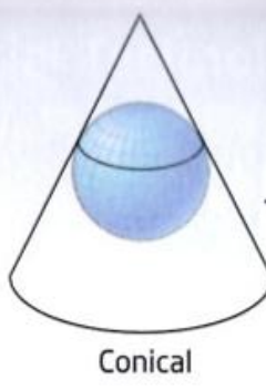
Conical
What type of projection is this?
Azimuthal
What type of projection is this?

Mercator Projection
Conformal - Keeps shape and angle; area grows toward the poles
Sinusoidal Projection
Equal-Area - sizes are true, but shapes shear away from the center
Equal-Area Cylindrical Projection
Equal-area - Sizes are true, shapes are squashed at high latitudes
Robinson Projection
Compromise - Neither exact, but both look near-right in the mid-latitudes
Datum
A foundation and reference frame for measurements
Fixes where position sit in 3-D relative to a model of the Earth
Answers: “measure relative to what”
Projection
A two-dimensional representation of a 3D
Draws those 3D positions onto a flat map - and always adds some distortion
Answers: “how do we show it flat?”
60 zones
The world is divided into ___ ______, each of them being 6° of longitude wide.
cylindrical projection
Each zone gets its own ______ ________ to keep distortion low
False Easting
Each zone’s central meridian is set to an easting of 500,000 meters. Locations east of it add meters; west of it subtract - so values never go negative
False Northing
In the southern hemisphere, the equator is set to 10,000,000 meters and values count down going south - again avoiding any negative coordinates
Universal Transverse Mercator (UTM)
60 metric zones, each 6° wide, worldwide
Universal Transverse Mercator (UTM)
A worldwide metric grid
State Plane Coordinate System (SPCS)
State-by-state high accuracy zones
Reproject
Change data from one projection/system to another
Spatial reference
A real-world coordinate system used to identify locations. It ties data to an actual place on Earth
Georeferencing
Aligning an unreferenced dataset with one that has spatial reference information
Reproject
The data ALREADY has a spatial reference
You’re converting it from one system to another
Math is known - The software just transforms coordinates
Georeference
The data has NO spatial reference
You’re assigning it real-world coordinates for the first time
You pick control points and then the software solves the fit
Ground Control Points (GCPs)
The tie spots where coordinates are known. They connect the unreferenced data to the source and anchor the whole alignment
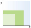
Rotation
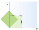
Skewing

Translation

Scaling
Root Mean Square Error (RMSE)
Measures how well your data lined up - The lower the better
X=Ax+By+C; Y=Dx+Ey+F
What are the equations for the Affline Transformation
Resampling
Recomputing pixel locations/values after warping
Road intersections, Building Corners, Well-defined and findable in both datasets, doesn’t change over time
What would make a good control point?
The U.S. Department of Defense
Who made GPS?
U.S. Navy Transit & NRL Timation
The “GPS” in the 1960’s
The 2nd Space Operations Squadron
Who runs the NAVSTAR GPS today?
GPS
The U.S. NAVSTAR system specifically
Free and available worldwide
Just one of Several such systems
Global Navigation Satellite System (GNSS)
The umbrella term for all systems
Includes GPS, GLONASS, Galileo, BeiDou, & and more
Space segment, Control Segment, and User segment
What are the 3 segments of GPS
Space Segment
The satellites in orbit broadcasting signals
24
How many satellites make up a full constellation
Control Segment
The ground crew that helps keep the satellites readings stay true
User segment
Involves any receiver - a one-way listener
Almanac
The general status and orbit data for the satellites, included in the broadcast
Ephemeris
More precise data on a satellite’s exact position in its orbit
C/A Code
Coarse acquisition - on L1; the code that civilian receivers use
P Code
Precise - on L1 and L2; more accurate, requires a military receiver
Y Code
An encrypted version of the P code (anti-spoofing)
M Code
A newer military code, more resistant to jamming
Distance = time x speed of light
What is the formula to find distance
Trilateration
3 distances are used to pin down one location
Differential GPS (DGPS)
A base station at a precisely known location measures the GPS error and broadcasts a correction to nearby receivers
Continuously Operating Reference Stations (CORS)
What provides differential corrections across the U.S.
Satellite Based Augmentation System (SBAS)
Sends the correction from an additional satellite instead of a ground station
WAAS
The FAA’s SBAS for North America - Ground stations feed geostationary satellites that broadcast a correct. Cuts error to 3 m or less
Europe
What region uses EGNOS and Galileo
India
What region uses GAGAN and NavIC/IRNSS
Japan
What region uses MSAS and QZSS
Russia
What region uses GLONASS
China
What region uses BeiDou
Geocaching
Small objects are hidden and their coordinates are posted online. You then use a GPS receiver to track them down
Multipath
Errors from signals bouncing off surfaces
Position Dilution of Precision (PDOP)
Error from poor satellite geometry - lower is better
Selective Availabilty
Intentional degradation of GPS accuracy - it was turned off in 2000
Sinusoidal
What projection is this?

Mercator
What projection is this?

Equal Area Cylindrical
Which projection is this?

Robinson
Which projection is this?

Universal Transverse Mercator (UTM)
What does this image represent?
