Unit 1 - Soil and Groundwater
 Call Kai
 Learn
Learn Practice Test
 Spaced Repetition
 Match
Match Flashcards
 Knowt Play
1/75

There's no tags or description
Looks like no tags are added yet.
Name | Mastery | Learn | Test | Matching | Spaced | Call with Kai | Chat |
|---|
No analytics yet
Send a link to your students to track their progress
76 Terms
Soil
A dynamic natural body composed of mineral and organic solids, gases, liquids and living organisms which can serve as a medium for plant growth.
Dirt
Soil that is out of place
All soil is a combination of ______.
clay, sand, and silt
Soil texture
Sand - gritty, largest particles (0.05 – 2.0 mm)
Silt - smooth, velvety, Intermediate (0.002 – 0.05 mm)
Clay - slick, sticky, Smallest (< 0.002 mm)
You can determine soil texture by:
texture by feel method, hydrometer or pipette
Soil texture influences the ______.
soil water and air movement
Texture by feel method

USDA Textural pyramid
shows 12 classes
Textural groups dependent upon the relative percentage of sand, silt and clay
all %’s add to 100

Soil horizons
layers of soil with distinct characteristics
a horizon, e horizon, and b horizon
A-horizon
surface layer, typically
darkened with organic matter from roots,
litter layer, etc.
E-horizon
zone of eluviation (leached through and left horizon causing different properties), where iron, aluminum, organic matter, and/or
clay was translocated to a deeper layer
not in all soils
B-horizon
layer of accumulation of clay, Iron, aluminum, organic matter
orange/reddish-brown color from iron
Adhesion
attraction of water and soil
Cohesion
attraction of water to water
Polarity of water
Positive side of water molecule attracted to
Negative surface charge of soil particles
Negative side of water molecule attracted to
Positive side of another (different) water molecule
Soil water
water in the unsaturated zone, held to soil particles by surface tension and adhesion → some water & air in pores
Capillary fringe
zone just above water table, where soil is almost completely saturated
(99%), but is held in soil matrix and will not drain under gravity
narrower the opening/pores the more suction → higher it can pull up above the water table in some cases
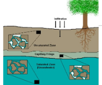
Water table
zone where soil is completely saturated → all pores are filled with water
Groundwater
water in the saturated zone
Soil Moisture Status
saturated, field capacity, and wilting coefficient
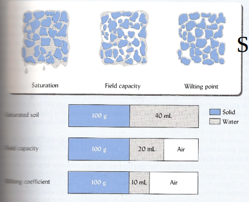
Saturated
all pores are filled with water
Field capacity
water from macropores has drained due to gravity → bigger pores have emptied
Wilting coefficient
water held too tightly by soil for plants to extract and plants die → plants can’t create a vacuum to get water out of the soil
matric force
attraction of water to soil solids, responsible for adsorption and capillarity
osmotic force
attraction of water to ions and other solutes (like salts)
submergence
pressure potential due to weight of water above a point
below water table → dealing with groundwater
Soil water potential
difference in energy levels of water between two sites
Gravity _______.
Pulls water down
Water moves in direction of ______.
decreasing potential (from high to low potential)
Dominant forces in determining where water goes
matric and osmotic force
Soil moisture content
high porosity = most open spaces to store water
on this graph, the soil that has high porosity is clay → why? think a sponge vs a straw →clay and loam retain water more quickly → sand drains so quickly (has large pores that are connected so water can transmit through it easily → effective porosity

Matric potential
the amount of suction the soil has on water (expressed in
Bars or kilopascals (kPa).
volumetric water content
volume of water associated with given volume of dry soil m3/m3
a measurement of water content
Mass water content
mass of water associated with a mass of dry soil kg/kg
a measurement of water content
Gravimetric method
most straightforward, often used to calibrate other methods
Soil sample from field (with water) weighed, dried and weighed again
Weight of water/weight of dry soil = mass water content
a measurement of water content
Neutron scattering
widely used field method for repetitive measurement of volumetric soil water content →a water content measurement instrument
based on the propensity of water molecules to slow down (thermalize) high energy fast neutrons emitted from a radio active source
the thermalized neutrons are counted by a detector present in the access tube (along with the source)

Time Domain Reflectometry (TDR)
a water content measurement instrument
sends a pulse of electromagnetic energy down the three parallel metal rod
makes precise picosecond measurements of the speed at which the pulse travels down the rods, a speed influenced by the nature of the surrounding soil
microprocessors analyze the wave patterns generated and calculate the dielectric constant of the soil (influenced by water content)
converts the dielectric constant into the volumetric water content of the soil
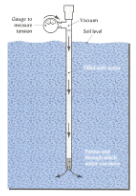
Tensiometer
water filled tube with one end sealed and the other capped with a porous ceramic tip. Inserted into soil, water flows out of tip until it reaches equilibrium with surrounding soil. As water is drawn out of the tube, there is a vacuum that is read with a gauge.
if the soil is already saturated → no vacuum
used a lot in golf courses
a Soil Water Potential Measurements
Resistance blocks
porous blocks with a pair of electrodes embedded in porous material and placed in soil- equilibrate with matric suction (tension) of soil water
When soil wets, electrical resistance between electrodes decreases and can be measured with meter →aka as soil gets wet, water dissolves the salts inside it, which increases the electrical conductivity (EC) of the soil
soil water potential measurement
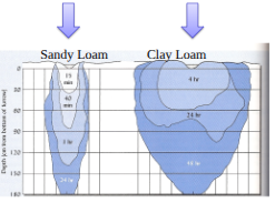
Wetting fronts for soils with relatively more micropores (small pores) will be more _______.
diffuse than soils with more macropores (larger pores). Smaller pores “pull” water in first, once the smaller pores are full, medium and then larger pores are filled in response to the pressure gradient.
ex: clay loam has smaller pores than sand loam
Groundwater
Subsurface water in the zone of saturation.
The capillary fringe is considered _______.
a part of soil water
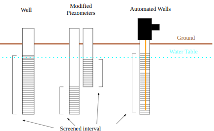
Groundwater sampling / monitoring devices
wells = measure hydraulic head → groundwater sampling
modified Piezometers = increase pressure of the water → measure pressure head
automated wells
GW moves in direction of ______.
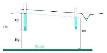
decreasing hydraulic head, along a slope or gradient
Hydraulic head (Hh)
the sum of gravitational head (Hg) and pressure head (Hp)
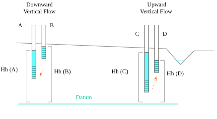
Vertical groundwater movement
downward flow = discharge
upward flow = recharge
hydraulic conductivity
how water moves in soil → a measure of a material’s ability to transmit water
Slug tests
measure hydraulic conductivity
in = displacing a known volume of water (slug) from a well and recording the time required to return to the original level), the quicker the return to original level, the higher the Ks
slug out = Measure initial depth to water, remove water from the well, and determine the time To return to initial depth ( in various intervals, using a stop watch and depth meter)
Pumping tests
measure hydraulic conductivity
pump water from a well and observe the response of nearby wells pump water from a well and observe the response of nearby wells
monitor drawdown nearby) Larger sample, more expensive, but better overall estimate of hydraulic conductivity ; need to know if confined or unconfined aquifer, and if the wells are partial or fully penetrating aquifer.
Darcy’s law
K(dh/dl) (m/day)
q = velocity (length/time)
K = Hydraulic conductivity (length/time)
dh/dl = Hydraulic gradient (length/length)
Pore water velocity
q / ne
ne = effective porosity → must have info on what type of media it is
Porosity
the % of total volume of rock or sediment that consists of pore spaces (including pores and fractures)
Effective porosity
the % of total volume of rock or sediment that consists of pore spaces that are connected
storage
the volume of water an aquifer releases from or takes into storage per unit surface area per unit change in head
aquitard
largely impermeable layers that hinder water’s movement (ex. clay)
aquifer
permeable rock or sediments that transmit water easily (ex. sand or gravel)
Confined (artesian) Aquifer
pressurized due to confining beds
Groundwater flow direction
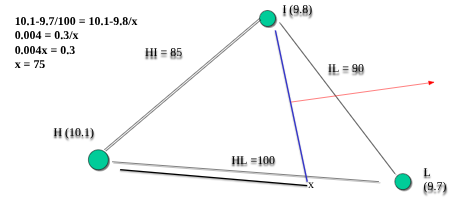
Equation: EH - EL/HL = EH - EI/x
EH is elevation of highest water level; EL is elevation of lowest; EI is elevation of intermediate.
HL is distance from wells with highest and lowest water elevations.
X is calculated distance from well with highest water elevation towards well with the lowest water elevation, where water elevation is the same as in Intermediate well (water level contour line). Flow direction is perpendicular to the contour line.
Groundwater Velocity
how quickly groundwater moves
Pores
primary openings that can provide storage and/or transmit water and air

Porosity
The ratio of openings (voids) to the total volume of soil or rock

Specific retention
ratio of the volume of water that is held on/in earth material under gravitational forces to the total volume of earth material
Specific yield
the ratio of the volume of water that can drain freely from saturated earth material (gravity) to the total volume of earth material
Influent
losing flow → water infiltrates through the stream bed and goes into the groundwater
a stream groundwater interaction

Effluent
As you move from the head water to estuaries → flow is gaining due to flow into multiple tributaries
a stream groundwater interaction

Perched
Feeding groundwater through the capillary fringe
a stream groundwater interaction

Discharge
velocity x cross-sectional area of stream (mean depth x width)
volume/time (ft3/s; gallons/s; m3/s; Liters/s)
a stream flow measurement
Velocity
measured with flow meter or floating object method
distance/time (ft/second; m/second)
a stream flow measurement
Deeper aquifers, such as confined aquifers are _______.
less likely to let pollution through → less water treatment is required

Confined aquifers
pressurized aquifers that don’t need a pump to access water
Geology influences ________.
groundwater supplies
Flooding and recession periods associated with glaciers _______.
resulted in superficial and confined aquifers
Water levels in aquifers vary based on _______.
water withdrawals (pumping) and recharge rates.

Central Coastal Plain Capacity Use Area
Regulated portion of eastern NC where some aquifers have experienced dewatering (pressure drops below confining unit causing air to enter pores and settling), saltwater encroachment (because of low water levels and low pressure, water was drawn in from estuaries →high to low pressure movement), and declining water levels that are not sustainable.
As a result, water use reductions were placed in areas of eastern NC and alternative water supplies were used.

Groundwater Management and Conservation Strategies
Utilizing more surface water supplies- Neuse Regional Water and Sewer Authority – Lenoir and Pitt counties from Neuse River; Martin county potentially using the Roanoke, Grenville Utilities using Tar River
Aquifer storage and recovery- using injection wells to store treated surface waters in confined aquifers for later uptake- Greenville Utilities
Utilizing other aquifer systems- Castle Hayne, surficial and Peedee aquifers – Jacksonville and Craven County
Construct surface water impoundments- agriculture users
Purchase waters from other systems
Invest in water reuse and conservation- industries
CCPCUA Program Results
Most aquifers experienced an increase in water levels after implementation of plans