PLN3 PRELIM: Theories and Concepts in Urban and Regional Planning
 Call Kai
 Learn
Learn Practice Test
 Spaced Repetition
 Match
Match Flashcards
 Knowt Play
1/87

Earn XP
Description and Tags
PRELIMS | PART 1 AND 2
Name | Mastery | Learn | Test | Matching | Spaced | Call with Kai | Chat |
|---|
No analytics yet
Send a link to your students to track their progress
88 Terms
What is Planning?
As a general activity, is the making of an orderly sequence of action that will lead to the achievement of a stated goal or goals.
What is Planning?
Its main techniques will be written statements, supplemented as appropriate by statistical projections, mathematical representations, quantified evaluations and diagrams illustrating relationships between different parts of the plan.
What is Urban Planning?
Conventionally means something more limited and precise: it refers to planning with a spatial, or geographical, component, in which the general objective is to provide for a spatial structure of activities (or of land uses) which in some way is better than the pattern that would exist without planning.
What is Regional Planning?
Deals with the efficient placement of land useactivities, infrastructure, andsettlement growth across a larger area of land than an individual cityor town. Regional planning is related to urban planning as it relates land use practices on a broader scale. It also includes formulating laws that will guide the efficient planning and management of such said regions.
Origin of Urban Growth
from 1800 to 1940
Origin of Urban Growth
Modern urban and regional planning has arisen in response to specific social and economic problems, which in turn were triggered off by the Industrial Revolution at the end of the 18th century.
Planning before the Industrial Revolution
There were important cities before the Industrial Revolution e.g. Ancient Rome and Elizabethan
Planning before the Industrial Revolution
These cities had problems of economic and social organization: Rome had to be supplied with water brought over considerable distances by aqueduct (the word itself is Roman in origin), and the city developed immense problems of traffic congestion – which unfortunately have been inherited by the modern city two thousand years later.
Planning before the Industrial Revolution
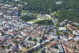
Many cities in both the ancient and the medieval world were planned, at least in the sense that their existence and their location were laid down consciously by some ruler or some group of merchants; and among this group, a large proportion even had formal ground plans with a strong element of geometric regularity.
Planning before the Industrial Revolution
The greatest flowering of formal town planning before the Industrial Revolution, though, came in what is known in continental Europe as the Baroque era: 17th and 18th Century

Planning before the Industrial Revolution
Many cities in both the ancient and the medieval world were planned with vast formal ground plans and a strong element of geometric regularity. These cities were planned, built and funded by prominent rulers or rich merchants at that era.

Planning before the Industrial Revolution
The greatest flowering of formal town planning before the Industrial Revolution, though, came in what is known in continental Europe as the Baroque era: 17th and 18th Century
Impact of Industrialism
At first the Industrial Revolution had no striking effect on urban growth.
Impact of Industrialism
The earliest of the new inventions in textiles or in iron-making, developed in England between 1700 and 1780
Impact of Industrialism
By the end of this period – and even later still, into the early nineteenth century – typical industrial landscapes, such as the cotton-making, woollen areas, iron-making and iron-working is a struggle of small industrial hamlets across an area that was fundamentally still rural.
Impact of Industrialism
Coal that changed the situation. As soon as it became a principal raw material of industry – replacing water power in textiles after 1780
Impact of Industrialism
It tended to concentrate industry where supplies could be made available: on the coalfields themselves, and then adjacent to bulk transport.
Impact of Industrialism
Britain, because it industrialized earlier than any other country, experienced special constraints on its industrial location pattern: the early machinery consumed great quantities of coal because it was inefficient, and the coal was very expensive to transport because there were no railways, only canals.
Impact of Industrialism
It created a new phenomenon: the new industrial town, developed almost from nothing – or perhaps from a small and obscure village origin – within a few years, on the coalfields of Lancashire and Yorkshire and Durham and Staffordshire.
Impact of Industrialism
Simultaneously, some towns – those which were neither port towns nor on coalfields – stagnated industrially. But many older-established medieval towns – because they were near enough to coalfields, or because they were on navigable water, or because they became railway junctions soon after the railways arrived – were also able to become major centres of the new factory industry (Leicester, Nottingham and Bristol)
Impact of Industrialism
Port towns were just as important as pure industrial towns in the whole process of industrialization, because they effected the critical exchange of raw materials and finished products on which the whole system depended.
Impact of Industrialism
The parallel with the cities of the developing world is, in several ways, only too exact. The people who flooded into the burgeoning 19th century industrial and port cities of Britain were overwhelmingly coming from the countryside. They tended to be drawn from the poorer section of the rural population: those who had least to lose and most to gain by coming to the city
Impact of Industrialism
These towns had only the most elementary arrangements, or none, for providing water, or clearing refuse or sewage, or for treating mass epidemics. Many of the towns, having sprung up so rapidly from villages, had virtually no arrangements at all.
Impact of Industrialism
Limited water supplies were increasingly contaminated by sewage; there were quite inadequate arrangements for disposal of waste, and filthy matter of all kinds remained close to dense concentrations of people; water supplies were lacking or fitful, and personal hygiene was very poor; overcrowding grew steadily worse, in the form of both more dwellings per acre and more people per room; cellar dwellings became all too common in some cities, such as Manchester or Liverpool; medical treatment, and above all public health controls, were almost completely lacking.
Impact of Industrialism
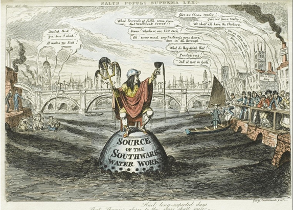
The greater mobility induced by trade meant that epidemics could move more rapidly across the world than ever before. This, plus polluted water supplies, was the basic cause of the terrible cholera epidemics that swept Britain in 1832, 1848 and 1866.
Impact of Industrialism
In 1831 a terrifying new epidemic arrived in London, bringing with it fear and panic—and a sense of urgency about the city's sanitation problems.
Dr. John Snow
Following the third cholera outbreak in 1854, Snow published an update to his theory, with statistical evidence that he had collected from an area of London around Broad Street, Soho. By recording the location of deaths related to cholera in the area, Snow was able to show that the majority were clustered around one particular public water pump in Broad Street.
Dr. John Snow
He eventually convinced local officials to remove the handle of the pump, although by that time the worst of the epidemic had actually passed. It was later established that a leaking sewer ran near the well from which the water was drawn.
London’s Sewage Network
Over decades the River Thames had effectively become London's largest open sewer, but it wasn't until the Great Stink of the summer of 1858— when the smell of raw sewage in the River Thames caused Parliament to close—that Londoners decided to do something about the city's sanitation crisis.
The Phenomenon of Urban Sprawl
Urban sprawl- sprawl or suburban sprawl, the rapid expansion of the geographic extent of cities and towns, often characterized by low density residential housing, single-use zoning, and increased reliance on the private automobile for transportation.
The Phenomenon of Urban Sprawl
Urban sprawl is caused in part by the need to accommodate a rising urban population; however, in many metropolitan areas it results from a desire for increased living space and other residential amenities.
The Phenomenon of Urban Sprawl
Urban sprawl has been correlated with increased energy use, pollution, and traffic congestion and a decline in community distinctiveness and cohesiveness.
The Phenomenon of Urban Sprawl
The growth of London, 1800–2000. Until 1850 London’s extent was constrained by walking distances. Steam trains from 1850 to 1914, and electric trains, tubes and buses from 1914 to 1939, allowed suburban spread – but then the green belt stopped it.
Reaction against Sprawl
A minority of thinking people, however, were alarmed at the result. They included both town planners, who by then existed as a profession – the Town Planning Institute had been incorporated in 1914 – and rural conservationists. They were concerned at the fact that the development was uncontrolled by any sort of effective planning. They argued that it had 2 bad effects:
Reaction against Sprawl: 2 Bad Effects
Development was using up rural land – the great majority of it agricultural land – at an unprecedented rate
Homes were being decentralized at greater and greater distances from the city centre, but jobs were not being decentralized nearly as rapidly.
Development was using up rural land – the great majority of it agricultural land – at an unprecedented rate.
Because the development was completely uncontrolled, it was no respecter of the quality of agricultural land: the suburban spread of London, for instance, took much of the finest market gardening land in all England, on the gravel terrace-lands west of the capital. The result, critics argued, was a major loss of home food production – a loss Britain could ill afford in times of war. And in the late 1930s, with war threatening, this seemed an important argument.
Homes were being decentralized at greater and greater distances from the city centre, but jobs were not being decentralized nearly as rapidly.
They argued that the effect on townspeople was equally bad. In London and in some of the bigger provincial cities, between the two world wars some factory industry was moving outwards to the suburbs in search of space: new factory estates were developed, But much industry remained in inner urban locations, and the growing volume of so-called tertiary industry – service occupations like work in offices and shops – seemed to be firmly locked in city centres.
Reaction against Sprawl
As a result, traffic congestion in the cities appeared to be growing; and journeys to work, it was assumed, must be becoming longer all the time. As cities grew larger and larger, as their suburbs sprawled farther and farther, it was argued that they imposed an increasingly insufferable burden on their inhabitants.

A house-agent’s advertisement of the early 1930s.
At this time house prices, aided by cheap labour and materials, were probably cheaper in relation to white-collar salaries than ever before or since. Commuting on the new electric lines round London was easy. There was a striking contrast with the poverty in the depressed industrial areas of the north.
The Seers: Pioneer Thinkers in Urban Planning
(1880 to 1945)
Anglo-American Group
Ebenezer Howard, Raymond Unwin and Barry Parker, Clarence Perry, Clarence Stein and H. Alker Tripp, Patrick Geddes and Patrick Abercrombie, and Frank Lloyd Wright
Continental European group
Arturo Soria y Mata, Tony Garnier and Ernst May, and Le Corbusier

Ebenezer Howard
Author of Garden Cities of Tomorrow is one of the most important books in the history of urban planning.

Ebenezer Howard
Was not a professional planner – his career, if he can be said to have had one, was as a shorthand writer in the law courts – but a private individual who liked to speculate, write and organize.

Three Magnets
The celebrated diagram from Garden Cities of To-morrow setting out the advantages and disadvantages of town and country life. A hybrid form for the future, the planned Town–Country or Garden City, combined the advantages of both with none of the disadvantages – so Howard argued
Important points about Howard’s ideas
The first is that contrary to the usual impression Howard was advocating quite a high residential density for his new towns: about 15 houses per acre (37/hectare), which in terms of prevailing family size at the time meant about 80–90 people per acre (200–220/hectare). (Today it would mean 40–50.)
Important points about Howard’s ideas
The second is that he did not advocate small, isolated new towns. His notion was that when any town reached a certain size, it should stop growing and the excess should be accommodated in another town close by. Thus the settlement would grow by cellular addition into a complex multi-centred agglomeration of towns, set against a green background of open country.

Raymond Unwin and Barry Parker
Two architects who designed the first garden city – Letchworth by Raymond Unwin (1863 1940) and his young assistant Barry Parker (1867–1947),
Important points about Unwin and Parker
Unwin and Parker developed some important modifications of the original Ebenezer Howard idea. Unwin argued that housing should be developed at lower densities than were then common. The need for public open space, he pointed out, was related to the numbers of people, so that the saving in land from higher urban densities was largely illusory.
Important points about Unwin and Parker
Unwin and Parker consistently argued for the Howard principle of generous green belts around the new communities
Important points about Unwin and Parker
Parker argued that the ‘background of open space’ between cities should be occupied by these parkways, giving easy interconnection between them; this in fact was an adaptation to the motor age of Howard’s original idea of an inter-urban railway.
Important points about Unwin and Parker
Parker employed yet another notion he had picked up in the United States, which was in fact a logical development of Howard’s own ideas: the idea of dividing the town into clearly articulated neighbourhood units. The ground plan of Wythenshawe as actually completed shows the influence of this idea.

Barry Parker
employed yet another notion he had picked up in the United States, which was in fact a logical development of Howard’s own ideas: the idea of dividing the town into clearly articulated neighbourhood units. The ground plan of Wythenshawe as actually completed shows the influence of this idea.

Clarence Perry, Clarence Stein and H. Alker Tripp
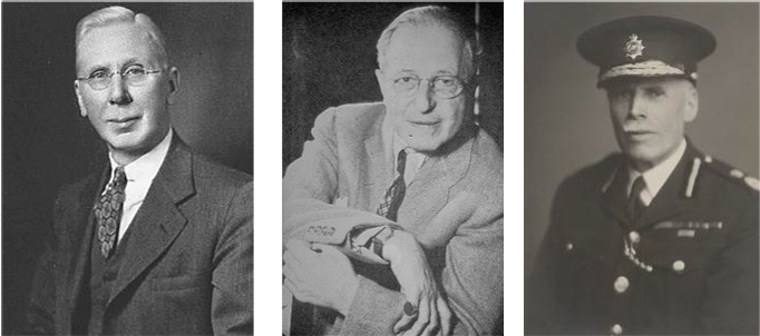
Clarence Arthur Perry (1872 – September 6, 1944) was an American urban planner, sociologist, author, and educator.

Clarence Perry, Clarence Stein and H. Alker Tripp
The essential idea of the neighbourhood unit, as developed by Perry – though not some of his details, such as putting shops at the corners of the units at the junctions of traffic roads – was enthusiastically taken up by British planners in new towns and in some cities after the Second World War; its influence is everywhere to be seen.
Clarence Perry, Clarence Stein and H. Alker Tripp
A close associate of Perry – Clarence Stein (1882–1975), an architect planner working in the New York region – had taken the neighbourhood concept further.

Clarence Perry, Clarence Stein and H. Alker Tripp
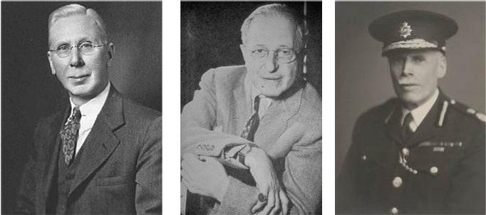
Stein was one of the first physical planners, apart from Parker in England and Le Corbusier in France, to face fully the implications of the age of mass ownership of the private car.
Clarence Perry, Clarence Stein and H. Alker Tripp
He grasped the principle that in local residential areas the need above all was to segregate the pedestrian routes used for local journeys – especially by housewives and children – from the routes used by car traffic.

The ‘Neighbourhood Unit’ principle
First developed by the American architect–planner Clarence Perry in the celebrated New York Regional Plan of the 1920s
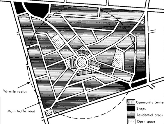
The ‘Neighbourhood Unit’ principle
This principle was based on the natural catchment area of community facilities such as primary schools and local shops. It was copied by Parker at Wythenshawe and then widely in British plans after the Second World War.
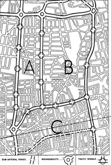
Clarence Perry, Clarence Stein and H. Alker Tripp
Tripp, a senior traffic policeman at Scotland Yard, applied his ideas to a part of London’s East End.
Clarence Perry, Clarence Stein and H. Alker Tripp
Main roads would be largely sealed off from local side access, to give better traffic flow and safety; residential areas would be protected from heavy traffic. This arrangement would later be questioned by practitioners of the ‘new urbanism’.
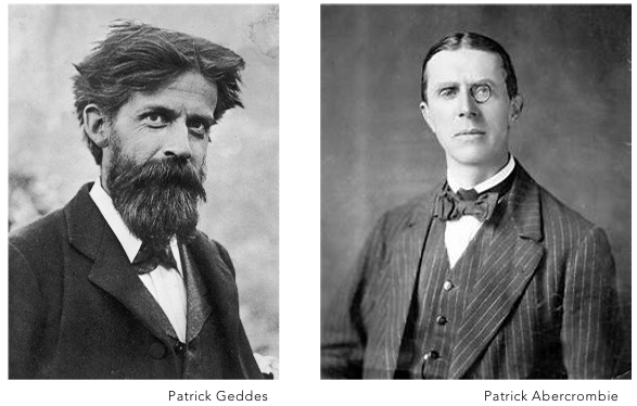
Patrick Geddes and Patrick Abercrombie
Abercrombie’s most notable contributions to Anglo-American planning theory and practice, however, were made in extending city planning to a wider scale – the scale which embraced the city and the whole region around it in a single planning exercise.

Patrick Geddes and Patrick Abercrombie
A visionary Scots biologist, Patrick Geddes (1854–1932), Geddes’s extraordinary mind soon took him away from conventional biology into the area we should now recognize as human ecology: the relationship between humans and their environment. In turn he was led to a systematic study of the forces that were shaping growth and change in modern cities, which culminated in his masterpiece Cities in Evolution
Patrick Geddes
Geddes’s contribution to planning was to base it firmly on the study of reality: the close analysis of settlement patterns and local economic environment. This led him to go right outside the conventional limits of the town, and to stress the natural region – a favourite unit of analysis of the French geographers – as the basic framework for planning.
Patrick Abercrombie
Abercrombie’s great achievement was to weld this complex of ideas, from Howard through Geddes to Unwin, and turn them into a graphic blueprint for the future development of a great region – a region centred on the metropolis but extending for 30 miles (50 km) around it in every direction, and encompassing over 10 million people.
Patrick Abercrombie
The broad aim of the plan was essentially Howard’s: it was the planned decentralization of hundreds of thousands of people from an overcrowded giant city and their re-establishment in a great series of new planned communities, which from the beginning would be self-contained towns for living and working.
Patrick Geddes and Patrick Abercrombie
The method was essentially Geddes’s survey of the area as it was, including the historical trends which could be observed, followed by systematic analysis of the problem, followed by production of the plan. But the great sweep of the study, its characteristic assurance, and its quality of almost cartoon-like clarity were essentially Abercrombie’s own.

Frank Lloyd Wright
was an American architect, interior designer, writer, and educator, whose creative period spanned more than 70 years, designing more than 1,000 structures, of which 532 were completed. Wright believed in designing structures that were in harmony with humanity and its environment, a philosophy he called organic architecture.
Frank Lloyd Wright
Wright based his thinking on a social premise: that it was desirable to preserve the sort of independent rural life of the homesteaders he knew in Wisconsin around the 1890s.
Frank Lloyd Wright
To this he added the realization, based on the early spread of the motor car among the farmers of North America, that mass car use would allow cities to spread widely into the countryside. With the car and with cheap electric current everywhere, Wright argued, the old need for activities to concentrate in cities had ended: dispersion, not only of homes but also of jobs, would be the future pattern.
Frank Lloyd Wright
He proposed to accept this and to encourage it by developing a completely dispersed – though planned – low-density urban spread, which he called Broadacre City.
Frank Lloyd Wright
Here, each home would be surrounded by an acre of land, enough to grow crops on; the homes would be connected by superhighways, giving easy and fast travel by car in any direction.
Broadacre City
Low density Urban Spread
European Tradition
Planning as a tradition in Europe goes back to the ancient Greeks. In the nineteenth century it produced such celebrated designs as the reconstruction of Paris under Georges Eugène Haussmann (1890–1), which imposed a new pattern of broad boulevards and great parks on the previous labyrinthine street pattern. But since our task here is to understand how new ideas transformed town planning into city-regional planning, we again look at the visionaries.

Arturo Soria y Mata
A Spanish engineer

Arturo Soria y Mata
In 1882 he proposed to develop a Linear City (La Ciudad Lineal), to be developed along an axis of high-speed, high intensity transportation from an existing city. His argument was that under the influence of new forms of mass transportation, cities were tending to assume such a linear form as they grew

The Linear City, 1882
This concept of the Spanish architect Arturo Soria y Mata, based on a central rapid transit system, was actually begun outside Madrid but has now been swallowed up in the general development of the city. It has been influential in many twentieth-century urban plans.
Tony Garnier
Tony Garnier (1869–1948), an architect working mainly in the city of Lyon, produced in 1898 – the same year precisely as Howard’s was published – a design for an industrial city (Cité industrielle) which, like Howard’s garden city, was to be a self-contained new settlement with its own industries and housing close by.
Tony Garnier
Cité industrielle


Ernst May
In the city of Frankfurt am Main, in 1920s the city planner and architect Ernst May (1886–1970) developed a series of satellite towns (Trabantenstädte) on open land outside the built-up limits, and separated from the city proper by a green belt.

Ernst May
These were not true garden cities on the Howard model, for most workers had to commute into the city – in that respect they somewhat resembled the Wythenshawe development in Manchester at about the same time – but they were remarkable for their detailed design treatment, in which May combined uncompromising use of the then new functional style of architecture with a free use of low-rise apartment blocks, all set in a park landscape

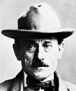
Le Corbusier
Swiss-born architect Charles Edouard Jeanneret (1887–1965), who early in his professional career adopted the pseudonym Le Corbusier, stands with Frank Lloyd Wright, Walter Gropius and Mies van der Rohe as one of the creators of the modern movement in architecture

Le Corbusier
His central ideas on planning are contained in two important books, The City of Tomorrow (1922) and The Radiant City (La Ville radieuse, 1933)

Le Corbusier Propositions
The first was that the traditional city has become functionally obsolete, owing to its increasing size and increasing congestion at the centre. As the urban mass grew through concentric additions, more and more strain was placed on the communications of the innermost areas, above all the central business district, which had the greatest accessibility and where all businesses wanted to be.
Le Corbusier Propositions
Second was the paradox that the congestion could be cured by increasing the density. There was a key to this, of course: the density was to be increased at one scale of analysis, but decreased at another. Locally, there would be very high densities in the form of massive, tall structures; but around each of these a very high proportion of the available ground space – Corbusier advocated 95 per cent – could and should be left open
Le Corbusier Propositions
Corbusier proposed to do away with all this by substituting virtually equal densities all over the city. This would reduce the pressure on the central business districts, which would in effect disappear. Flows of people would become much more even across the whole city, instead of the strong radial flows into and out of the centre which characterize cities today.
Le Corbusier Propositions
He argued that this new urban form could accommodate a new and highly efficient urban transportation system, incorporating both railway lines and completely segregated elevated motorways, running above the ground level, though, of course, below the levels at which most people lived.