unit 3
 Call Kai
 Learn
 Practice Test
 Spaced Repetition
 Match
 Flashcards
 Knowt Play
1/38

There's no tags or description
Looks like no tags are added yet.
39 Terms
what is climate?
study of how the sun’s energy is trapped + transported across earth
average weather + variability in a location
temperature, humidity, precipitation etc
greenhouse effect
slows down loss of energy into space
keeps warm enough for life, human intervention → global warming
earth absorbs solar radiation (earth heats)
radiation also emitted from earths surface (earth cools down)
hotter = more radiation emitted
Sunlight enters Earth's atmosphere.
Earth's surface absorbs sunlight and warms up.
Earth releases heat as infrared radiation.
Greenhouse gases absorb and re-emit some of that heat.
Some heat escapes into space, while some returns toward Earth's surface.
greenhouse gases
H2O
CO2
CH4
N2O
radiative balance
earth heats up enough to where it emits as much radiation as it absorbs
earths climate system

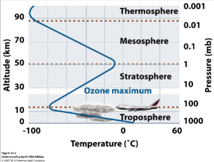
earth atmosphere
alt inc → pressure decrease
lowest alt.
troposphere (coldest)
stratosphere (warm)
mesosphere (warm)
thermosphere (cold)
mostly N
next biggest O
small argon
CO2
trade winds
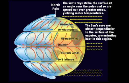
equator: receives direct sunlight (warmer)
poles: angled sunlight (earth tilt = cold)
trade winds = blow toward equator
NE t.w (northern hem)
SE t.w (southern hem)
westerlies: W→ E
coriolis effect (E rotation = curve wind)
global circulation: moves heat around
hydrosphere
all liquid water in earths surface
oceans, lakes, rives, groundwater
water transports better than air
thermohaline circulation (?)

el nino
warm sea surface T in east equator pacific
normal behavior = cool NE + SE trade pushes warmth away from EEP
el nino = cold air from both sides cause heat to swell in 1 area
cryosphere
albedo
snow + ice so white they reflect alot of sun energy back to space
lithosphere
continents heat and cool more than oceans
topography
mountains influence wind pattern
colder → inc elevation
volcanism
injects particulates (tiny solid/liq particles suspended in air)
that black solar radiation = cooling
biosphere
all organisms living near Earth’s surface
organisms heavily influence water + carbon cycle
plants influence albedo
carbon cycle
biological
plants absorb CO2 + sunlight releasing O2
animals eat plants + animals to pass carbon through food chain
microbes break down dead plants + animals releasing CO2
global carbon reservoirs
atmosphere holds CO2 interacts w/ land + ocean
oceans absorb CO2 + store in plankton remain
ancient plant + animal remains form fossil fuels
carbon budget + human impact
emissions: human activities add to atmosphere (fossil fuel burning, deforestation, etc.)
uptake: new plant growth and air-sea gas exchange
feedbacks
positive: change in one component = enhanced by change it does on other
inc CO2 = respiration for animal remain inc = CO2 increase
CO2 inc = surface T inc = ice cap melp = earth albedo decrease = surface T inc
negative feedback: change in one component reduced by change it does on others
ex: inc CO2 = plants grow faster = less CO2
climate variability
[add more of this]
climate has varied in past → rate of modern climate change = alarmingly fast
Milankovitch cycles
eccentricity
(how much Earth's orbital path around the Sun departs from a circle)
tilt
(earth tilt due to orbital plane more tilt = more extreme temps)
precession
(wobble of earths axis)
weathering (chem, phys, feedbacks, O2, CO2)
breakdown and fragmentation of rocks
chemical
chemical alteration in presence of water/air
physical
mechanically fragmented without change in composition
joints (fracturing with no faulting)
bedding + cleavage
roots
exfoliation (outer layer of rock flake away in thin sheets/slabs)
frost wedging (ice expands as it freezes + crack expands + frag)
more Si = weathers least
olivine → pyroxene → amphibole → biotite → muscovite/quartz/feldspar
calcium P feldspar → sodium
feedbacks (positive)
chemical removes material + loosens grain = weaken rock →
physical frags weaken rock →
frag inc surface area exposed to air and water →
inc area = inc rate of chemical weathering
feedback (negative)
CO2 inc
climate warms + plants/microorg. grow faster
weathering inc
CO2 dec
erosion
removal of weathered mat from source
water
like water + coffee (top is ground coffee and bottom is liquid coffee and other substance)
soil is feldspar at the top and kaolinite clay and other at the bottom
ex
granite made of crystals that decay @ diff rates
cracks form + biotite + magnetite decay
decay progresses + rocks disintegrates
mass wasting
collapse of hillsides
angle of repose
particles dropped in pile create angle of repose based on size (cone shaped)
fine sand has a shallower angle than pebbles
water saturated sand keeps grains apart = less cohesive
soil
residue of chemical weathering
soil retains water + remain wet
plants + microorgs produce acids
most valuable natural resource
food supply
buildings on soil
tropical soil = valuable aluminum ores
soil + climate linked (need soils to study climate)
gradient
O horizon = decomposing org matter
A horizon = weathered mineral grain + org matter
E horizon = max dissolution + max remove mineral grain + org matter
B clay minerals (Fe and Al, calcite) combination of phys transport from upper, water infiltrating, + in place weathering
C horizon: unweathered / slightly weathered parent
bedrock
translocation: minerals/grains may move through soil
transformation: precipitates form from fluids within pores in soil
factors
time
climate
more annual precipitation = calcite pushed down/dissolved = taller / lush vegetation (forest)
topography
parent material
more Si = slower weathering (hematite, quartz, clay)
less Si = faster (halite, calcite, olivine)
organisms

where is earths water
reservoir = storage for water
most in ocean
then glaciers
underground water
lakes
atmosphere
biosphere
hydrologic cycle
models the movement of water from one reservoir to another
hydrology and climate
relative humidity
amount of water vapor in the air (% water the air could hold if saturated)
warm air holds more than cold
warm air cools = supersaturated (water condenses) → clouds
orogenic rain shadow
wind carry warm air over oceans (gains moisture)
moist air + mountains = rises + cools (rain/snow)
result = rainy windward slope
air passes over mountain, cold air has no more moisture + sinks
dry slope/rain shadow formed (desert)
precipitation

runoff
water flowing due to gravity not evaporation or infiltrating soil
Half the global runoff is carried in the 70 largest rivers
half of that is carried in the Amazon alone.
amazon most, Mississippi least
surface reservoirs = lakes + wetlakes
dry period = low reservoir low runoff
wet period = high reservoir high runnoff
dams and natural reservoirs only release water slowly despite dry/wet periods

ground water
groundwater = part of subsurface water in saturated zone (phreatic)
water table
boundary between unsaturated zone (vadose) and saturated (phreatic)
vadose (higher up)
water + air both occupy pore spaces
soil + weathered bedrock
phreatic (lower)
water fills all pore spaces
easy to pump out but slow to recharge
pumping exceeds recharge → resource depletes
porosity
porosity
percent rock volume that is pores (spaces)
porosity increases with increased sorting
independent of grain size
permeability
ability to allow fluids to pass through
interconnectedness of pores
decreases with decreasing grain size, porosity, and sorting
infiltration
surface water infiltrates into unsaturated zone
gravity + capillary forces, moves into water table
groundwater moves by gravity + pressure difference along a head gradient
ground water moves from high head to low head not always downhill
recharge
addition of water that causes water table to inc
inc evap/withdrawal by pumping lowers table
cone of depression
water pumped faster than it can recharge
salt water is denser than fresh
too much pumping = water supply might turn brackish as salt pulled into pump

aquifer
any permeable saturated layer that can transport water
unconfined
upper bound defined by water table
confined
upper bound is aquitard
ogallala aquifer
karst aquifer
edwards aquifer

aquitard
impermeable layer prohibiting flow of water (ex shale layer)
artesian well
well that brings ground water up without pumping
under pressure within surrounding layers of impermeable rock
springs
ground water discharge feature
forms wherever the land surface intersects water table