IVC For Good
 Call Kai
 Learn
 Practice Test
 Spaced Repetition
 Match
 Flashcards
 Knowt Play
1/35

There's no tags or description
Looks like no tags are added yet.
36 Terms
Mohenjo Daro site structure
City with a well-defined grid plan
Upper and lower town like many other IVC cities
Upper mound is smaller, location of the Great Bath
Early Mohenjo Daro archaeology - focus and challenges
Early work is a just-so story (bad bad bad)
Chronology is difficult because the work was done prior to radiocarbon dating
Marshall, Mackay, and Wheeler focused on the Upper Mound
Expected it to reveal evidence of a hierarchical kingdom/ theocracy
The Citadel/ The Upper Mound
Some walling, very architecturally engineered
The naming is random, not descriptive of its actual function
Contains a number of large public structures
Lower Town
North-south grid of residential areas and craft production
Many craft areas isolated from residential houses - very planned
Incredible sewer system
Platforms, walls, and gateways
Made of standardized (burnt and unburnt) brick
Mohenjo Daro public works
Extensive
Lots of public buildings separated from residential areas
Building functions unknown
Mohenjo Daro bricks
Different sizes, but always a 1:2:4 ratio
Fired bricks used for foundation platforms and wall bases to protect against floods
Some special bricks were used to hold water
Mohenjo Daro walls and gates
Massive retaining wall used to elevate the upper town
Largely built at the same time and regularly maintained
Walled sectors throughout the city suggest civic organization of neighbourhoods
~2.5 m wide passages narrowing doorways
Possible crowd control within and at entrances of cities
At Harappa, there are gates between at least four sectors of town
Adjacent rooms at gateways
To monitor access?
Many standardized weights found there - toll stations?
Indus Metrology (standardized weights)
Origins in the early Harappan period
Cubical
Weights double with increase
1:2:4:8:16:32
16th ratio = 13.7 grams
Made from primarily Rohri sourced stone
Mesopotamian texts refer to Upper Persian gulf-made weights
Cylindrical like Mesopotamian seals
But used the IVC ratio system
This implies exchange
Mohenjo Daro brick platforms
Everywhere? Everywhere.
Elevated open spaces
Both in public and private areas
Used to raise the city above the flood plain (early on)
At least 700 (Jansen)
Mohenjo Daro streets and laneways
4.5 - 9m wide
Enough for two bullock carts
Smaller streets were around 3m wide
North-south oriented
Not paved, but hard debris/ ceramic trash in construction
Well-compacted
Maintained
Used for hundreds of years - raised with maintenance
Covered, burnt brick-lined drains for rainwater
Would have been cleaned
Floods now threaten these sites, rains still go through the urban drainage system
Importance of Urban Water
“Collective Consciousness” ?
Jansen supports this
Almost every house had a toilet
Bathing platforms (Kenoyer)
Water management was a civic responsibility, likely with ritual significance
“Wasserluxus” - unifying ideological use of water
Drinking, bathing, sewage were important everywhere in the IVC
Different strategies at different sites - i.e Dholavira has reservoirs and stone/ brick channels
More than 700 wells (specifically ring wells) found at Mohenjo Daro (within the ~ 25% of the site that is excavated)
A well estimated for 1-3 houses
Some private
Widely distributed
Made with wedge-shaped bricks (Kenoyer)
Sewage and water runoff disperse waste outside of the city
Waterworks as distinctly Mature Harappan (Jansen)
Mohenjo Daro bathing platforms (Jansen)
2 m2 or smaller
Bricks around the edge form a shallow basin
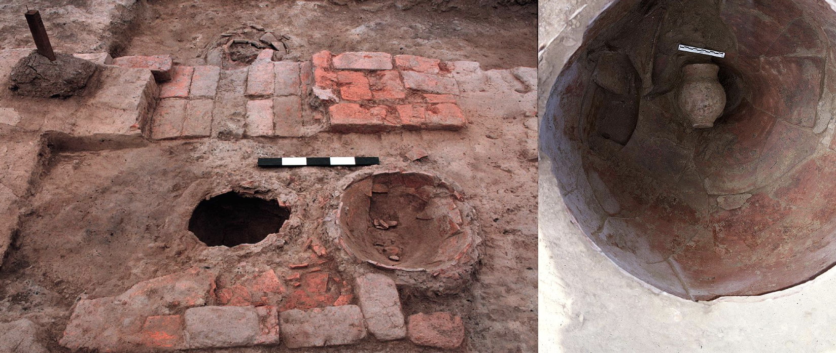
Mohenjo Daro Toilets
Often with commodes with a water pot for washing
Small jars found in latrines
Some were cleaned into street drains, some emptied into underground channels leading to cesspits
Locations that were smelly/ harder to clean were farther away from large houses
Social stratification
Sumps were important (hold refuse)
Bathing platforms of watertight brick - by the exterior house wall to connect to the sewer system
Required integration between neighbourhoods
Toilet practice as Durkheimian integration
Argument for social order based on waste management and order of body functions

Mohenjo Daro sewage system (Jansen)
Drains usually located on one side of the street
Covers could be removed for cleaning
Sloped by 2 cm per meter
Cesspools at junctions prevented clogging
Houses could be connected to the mains
Homogeneously distributed across the city
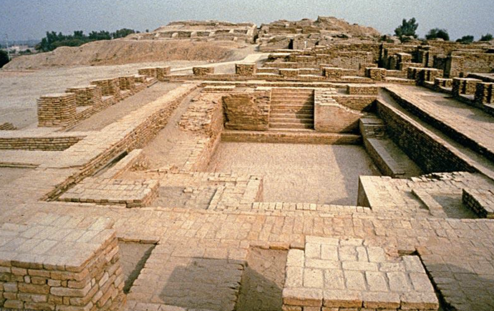
The Great Bath
1 well, several small rooms
At the centre of the highest site
Later addition (Jansen)
Adjacent to the foundations of the “granary/ warehouse”
Surrounded by 5m wide streets immediately after its construction (Jansen)
3 concentric zones: the streets, the walls, the basin
May have applied to ritual processions
Made of concentric walls with specially constructed bricks
Fit together better than regular bricks
Bitumen sealant
2m thick outer walls which taper at 80 degrees (Jansen)
Associated bathing platforms
Public ceremonies of ritual bathing
Mirrors home-based bathing
Would have had a wooden superstructure but been open-air
Access restriction is unclear
But connection to main street
Unique structure for an urban Indus site
Supplied by a well (Jansen)
Has a massive drain
Cuts across, evidence for later construction of the Great Bath (Jansen)
Lost its function in later alterations (Jansen)


The Great Bath - dimensions
12m x 7m x 2.4m
1700 m2 (Jansen)
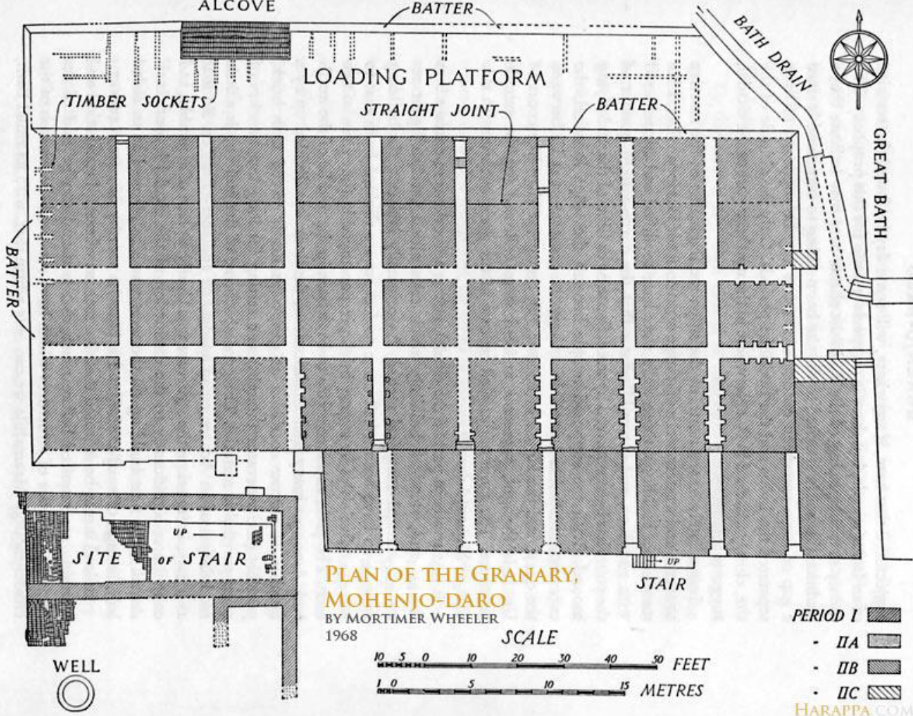
The “Granary/ Warehouse”
Massive set of burnt brick foundations
Adjacent to the Great Bath
Similar structures found in Harappa, later sites
Initially interpreted as central grain storage, but there is no evidence for this
Now considered a warehouse, but it’s still uncertain
Sockets point to a massive timber superstructure
The stairs in the foundation walls are not from the city side
Indicates directed movement
Single-story
The “College”
The only possible residential structure
Perhaps for priests
But this is just an extrapolation from Mesopotamia, not actual evidence
70m x 24m structure
Contains smaller cells
Mohenjo Daro Houses
Several rooms for sleeping and cooking areas
Arranged around courtyards near the centre/ north of the house
Several rooms back from the street
Upper stories in earlier builds
Roof/ second floors made of wooden beams, reeds, and plaster (Kenoyer)
Walls got thinner over time, so later buildings were not able to support two floors
Entrances from side alleys (Kenoyer)

Mohenjo Daro house plans
Most had a modular design
Sarcina identifies 5 modules
The smallest: 97 m2
Larger ones: 183 m2
Some even: 600 m2
These differences are not huge, relatively speaking
There is room for both expansion and individual elements
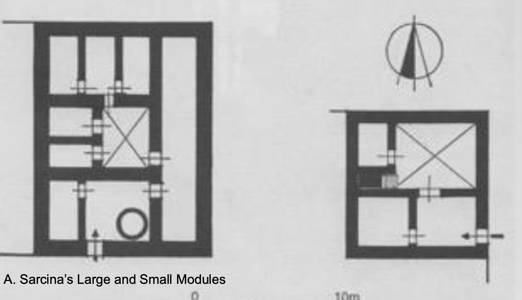
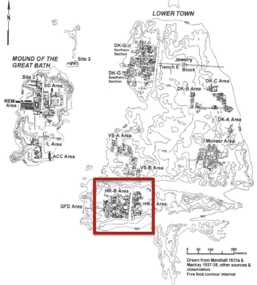
Mohenjo Daro neighbourhoods
Raised/ lowered areas within the lower town
In the southwest: HR area (sectors A and B)
Dense housing along alleys and streets, where people would have met
Variety of houses and sizes along Sarcina’s modules
One possibly wealthy/ elite household

Mohenjo Daro specialized crafts (Kenoyer)
Stone tools
Shell working
Bead making
Copper metallurgy
Faience (very strong)
Stoneware
Pottery
Mostly fast-wheel
Often undecorated or with red and black stripes
Textiles: important industry
Wool
Cotton
Many crafts were subject to taxation
Import of raw materials, export of trade
Sometimes made in isolated areas
Ornaments were made in similar styles, but in different qualities/ expensive materials
Mohenjo Daro trade and economy (Kenoyer)
Highly stratified economic system
Large network of stable connections
No coinage system - weights?
Possibly inscribed tablets
Burial and property ownership
Indicates matrilocal living
Property and locality were held by women
Only ~600 burials found across the IVC
Homogeneous
Not many grave goods
O2 and Sr isotopes in bones originate in groundwater/ geology - can be used to determine the origin of skeletons
Form early life signatures in teeth
Form adult signatures in bones
Skeletons demonstrate two groups
Locals
Non-locals (exclusively male)
Males may have married in
HR Area: House 1
Flues for heat in winter
Patterned brickworking
Recovery of contents is poor, but some statuary, caches of wealth in the walls
Hoards: metals, tools, non-local semiprecious stone items
A lot of bull-motif seals
Interpreted as the house of wealthy traders?
Seals used as insignias and stamps for consignments
The “Priest-King” statue is from here
Rare and valued representation, but not like the representation of kings in Mesopotamia
3 interpretations of wealth/ hoards in the IVC
No clear wealth culture
Secreting away wealth
Storage practice for later economic activities
Storage of valued goods
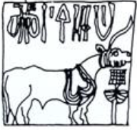
Bull/ “unicorn” motif
On ~ 60 percent of seals
Stylized over the side
IVC Religion (Kenoyer)
Shared throughout the religion
Seals showing:
Geometric symbols
Figurines
Narrative scenes
Burial and ritual practice (Kenoyer)
Buried in North-South orientation
Not much material wealth
Nonetheless, indications of privilege (shell bangles, etc)
Social Status in Mohenjo Daro/ IVC
Hierarchies masked or non-existent?
No good understanding
No deciphered script (Kenoyer)
May be a heterarchy (Green)
Would explain the high degree of organization despite no obvious political hierarchy
Some social classes (Kenoyer)
Administrators
Service classes (i.e. drain cleaners)
Wealthy landlords
Merchants
Craftspeople
Gateway workers
Farmers and rural people
Rulers (potentially corporate)
Loose stratification, controlled by influential elites? (Kenoyer)
Heterarchy
Social relations that are either unranked or have the potential to vary based on context
Collective action (Green)
Political process that incorporates large numbers of people into coordinated endeavors
Evidence for hierarchy in IVC
Widespread omogeneity of material culture
Large urban sites with careful planning and urban hydrology
Clear management of labour
Monumental architecture
Craft specialization
Agricultural surplus?
Extensive and diversified trade (including long-distance)
Evidence for heterarchy in IVC
No evidence for elite burials
Little evidence for elite residences
Little evidence for differential wealth or status
Centralized authorities?
Settlement patterns
Monumental architecture
Division of space and towns in cities
Block 6A and Block 8A (Green)
Buildings interpreted by Mackay as public
No courtyards or multi-use spaces
Green build a GIS layering different time periods of these buildings
Possibly associated with traffic
Prominent location
Become more accessible in later phases
May have been part of the same complex
Evidence for heterarchy from Block 6A and Block 8A (Green)
Open to multiple different groups
None with exclusive control over the area