Lecture 15 - Conditional Instability
 Call Kai
 Learn
 Practice Test
 Spaced Repetition
 Match
 Flashcards
 Knowt Play
1/33

There's no tags or description
Looks like no tags are added yet.
34 Terms
what are the requirements for cloud formation (any cloud type)?
(…)
() ()
a () mechanism to bring the air to saturation
water vapor
CCN (cloud condensation nuclei)
a cooling mechanism to bring the air to saturation
what are the two other things that contribute to the development of deep convective clouds?
conditional….
triggering…
conditional instability
triggering mechanism
what is conditional instability?
This describes an atmosphere that is primed and ready to (), but only if it gets a big enough ()
1. Normal, dry air resists () and likes to () back down. However, if the air is very () and packed with () (humidity), it behaves differently.
2. If you force this moist air () enough, the moisture () into () droplets (forming a cloud).
3. This condensation releases hidden () (latent heat), making the inside of the cloud () than the surrounding air.
4. Because warm air () like a hot air balloon, the cloud suddenly takes off on its own, growing rapidly into a massive ().
It is called conditional because the air won't () on its own while it is () near the ground; it must be () high enough to start () and () that heat.
This describes an atmosphere that is primed and ready to rise, but only if it gets a big enough push
1. Normal, dry air resists rising and likes to sink back down. However, if the air is very warm and packed with moisture (humidity), it behaves differently.
2. If you force this moist air high enough, the moisture condenses into water droplets (forming a cloud).
3. This condensation releases hidden heat, making the inside of the cloud warmer than the surrounding air.
4. Because warm air rises like a hot air balloon, the cloud suddenly takes off on its own, growing rapidly into a massive storm.
It is called conditional because the air won't rise on its own while it is dry near the ground; it must be lifted high enough to start condensing and releasing that heat.
what does a triggering mechanism mean?
() () motion to initiate () development and () condition
upward vertical motion to initiate cloud development and stable condition
what are the four possible triggers?
b….
t…
con…
lifting…
buoyancy
topography
convergence of air
lifting along weather fronts
explain buoyancy as a thunderstorm trigger
the sun () the earth’s surface, () the air just above the ()
because this warm air is () dense than cool air, it experiences an () buoyant force
air shoots (), creating a powerful (), then as it reaches higher, it () down, causing its moisture to () into towering cumulonimbus clouds, and then a TS forms
the sun heats the earth’s surface, warming the air just above the ground
because this warm air is less dense than cool air, it experiences an upward buoyant force
air shoots upward, creating a powerful updraft, then as it reaches higher, it cools down, causing its moisture to condense into towering cumulonimbus clouds, and then a TS forms
explain topography as a thunderstorm trigger
horizontal () push (), humid air across the land and when it hits a (…) like a mountain, it has nowhere to go but ()
the mountain acts like a ramp so the air is shoved () and it leaves the () lower atmosphere and enters much () regions higher up
forced () causes the invisible moisture in the air to rapidly () into liquid water droplets, releasing () heat, supercharging the updraft and generating towering TS clouds over the peaks
horizontal winds push warm, humid air across the land and when it hits a geographic barrier like a mountain, it has nowhere to go but up
the mountain acts like a ramp so the air is shoved up and it leaves the warm lower atmosphere and enters much colder regions higher up
forced cooling causes the invisible moisture in the air to rapidly condense into liquid water droplets, releasing hidden heat, supercharging the updraft and generating towering TS clouds over the peaks
explain convergence of air as a thunderstorm trigger
collision: winds blow from different () a ()-pressure area
squeeze: as the air column crowd into the () space, they () and since the air cannot move () into the dirt, it is violently squeezed together and forced ()
storm: forced () movement creates a strong, sustained (), as the (), moist air is pushed higher into the () layers of the atmosphere, the water vapor () into storm clouds
collision: winds blow from different directions meet at a low-pressure area
squeeze: as the air column crowd into the same space, they compress and since the air cannot move downward into the dirt, it is violently squeezed together and forced upward
storm: forced upward movement creates a strong, sustained updraft, as the warm, moist air is pushed higher into the colder layers of the atmosphere, the water vapor condenses into storm clouds
explain lifting along weather fronts as a thunderstorm trigger
in a cold front, a fast moving mass of cold air acts like a giant snowplow as it drives () the warm, humid air mass, violently shoving the () air straight () into the atmosphere
in a warm front, a moving mass of warm air encounters a retreating cold air mass, because the warm air is (), it rides () and over the heavier cold air like a gentle ramp
along steep, fast-moving cold fronts, the forced () movement creates massive (), as the () moist air is flung into the () atmosphere, it () into a line of TS
in a cold front, a fast moving mass of cold air acts like a giant snowplow as it drives underneath the warm, humid air mass, violently shoving the warm air straight up into the atmosphere
in a warm front, a moving mass of warm air encounters a retreating cold air mass, because the warm air is lighter, it rides up and over the heavier cold air like a gentle ramp
along steep, fast-moving cold fronts, the forced upward movement creates massive updraft, as the warm moist air is flung into the freezing atmosphere, it condenses into a line of TS
what is stratiform?
() clouds that form in () air
an externally () lifting causes the entire atmospheric layer to (), causing () clouds
forced lifting: (o), ( c), (f)
layered clouds that form in stable air
an externally forced lifting causes the entire atmospheric layer to ascend, causing layered clouds
forced lifting: orography, convergence, fronts
what is cumuliform?
() clouds that form in an () atmosphere
some mechanism (trigger) () air parcels until they become () buoyant; the parcels then () on their own, producing () developed clouds
heaped clouds that form in an unstable atmosphere
some mechanism (trigger) lifts air parcels until they become positively buoyant; the parcels then rise on their own, producing vertically developed clouds
what are the stages in the growth of cumulonimbus clouds? (4)
cuh…
cum…
cuc…
cumu…
cuhumilis:
cumediocris:
cucongestus:
cumulonimbus:
explain cuhumilis
Description: Also known as "()-weather cumulus." These are small, detached, and relatively () clouds with a () base and () vertical depth.
Atmospheric State: Indicates () or weakly () atmospheric conditions with mild convection.
Weather Impact: () weather; no ().
Description: Also known as "fair-weather cumulus." These are small, detached, and relatively flat clouds with a uniform base and minimal vertical depth.
Atmospheric State: Indicates stable or weakly unstable atmospheric conditions with mild convection.
Weather Impact: Fair weather; no precipitation.
explain cumediocris
() stage
these clouds exhibit () vertical advancement, being about as () as they are tall, with slightly () tops
suggests an increasing depth of () air and moderate ()
generally () weather, but signaling that the atmosphere is priming for stronger convection
intermediate stage
these clouds exhibit moderate vertical advancement, being about as wide as they are tall, with slightly bulging tops
suggests an increasing depth of unstable air and moderate updrafts
generally fair weather, but signaling that the atmosphere is priming for stronger convection
explain cucongestus
Description: Towering () clouds. They feature extreme () growth with deep, () bases and bright, () tops that look like bubbling towers.
Atmospheric State: Driven by highly () air and powerful, sustained () pushing () into the atmosphere.
Weather Impact: Capable of producing () rain showers, gusty (), and can rapidly transition into the final stage.
Description: Towering cumulus clouds. They feature extreme vertical growth with deep, dark bases and bright, cauliflowering tops that look like bubbling towers.
Atmospheric State: Driven by highly unstable air and powerful, sustained updrafts pushing high into the atmosphere.
Weather Impact: Capable of producing heavy rain showers, gusty winds, and can rapidly transition into the final stage.
explain cumulonimbus
Description: The ultimate () cloud. A massive, deep () cloud that spans the entire troposphere, whose top eventually () out into an icy, fibrous () shape.
Atmospheric State: Severe atmospheric () paired with intense () and ().
Weather Impact: Heavy (), frequent (), (t), (h), and the potential for severe weather like tornadoes.
Description: The ultimate thunderstorm cloud. A massive, deep convective cloud that spans the entire troposphere, whose top eventually flattens out into an icy, fibrous anvil shape.
Atmospheric State: Severe atmospheric instability paired with intense updrafts and downdrafts.
Weather Impact: Heavy downpours, frequent lightning, thunder, hail, and the potential for severe weather like tornadoes.
how can moisture affect stability?
() can cause a () air parcel to become () than its environment (buoyant) - conditional ()
latent heat due to…
can cause a rising air parcel to become warmer than its environment (buoyant) - conditional instability
latent heat due to condensation
what is a parcel?
volume of air that does not exchange () or () with surrounding air, yet adjusts to the ambient () pressure
volume of air that does not exchange heat or mass with surrounding air, yet adjusts to the ambient air pressure
what are the two ways rising air can change temperature?
() process (expansion or compression), without heat exchange
(…) exchange (with () phase changes)
adiabatic process (expansion or compression), without heat exchange
latent heat exchange (with H2O phase changes)
what is saturated-adiabatic lapse rate?
() (saturated) expanding air () as it rises
() degrees C per 1000 ft and () about () degrees C per 1000 ft as it descends and is compressed
NOT (), varies with air ()
caused by () or () being offset by (…) exchange
parcels () and () parallel to () adiabats
cloudy (saturated) expanding air cools as it rises
2 degrees C per 1000 ft and warms about 2 degrees C per 1000 ft as it descends and is compressed
NOT CONSTANT, varies with air temperature
caused by expansion or compression being offset by latent heat exchange
parcels rise and sink parallel to saturated adiabats
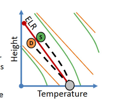
what is conditional instability?
occurs when () < () < ()
SALR is () than ELR and DALR is () than ELR
the layer is stable for an () air parcel but unstable for a () air parcel so it is termed “conditionally unstable”
inside cloudy air parcels, the rising air becomes () due to (…) release by (…) phase change
occurs when SALR < ELR < DALR
SALR is less than ELR and DALR is greater than ELR
the layer is stable for an unsaturated air parcel but unstable for a saturated air parcel so it is termed “conditionally unstable”
inside cloudy air parcels, the rising air becomes warmer due to latent hear release by water vapor phase change
what is absolutely stable air?
() < () < ()
ELR is () than SALR and DALR is () than SALR
rising air will end up () than surroundings regardless of whether it is () or ()
() acts to restore parcels to initial altitude
ELR < SALR < DAL
rising air will end up cooler than surroundings regardless of whether it is saturated or unsaturated
buoyancy acts to () parcels to initial altitude

what is absolutely unstable air?
() < () < ()
SALR is () than DALR and ELR is () than DALR
rising air ends up () than surroundings regardless whether rising air is () or ()
(), except near () ground
() accelerates parcels () from initial altitude
SALR < DALR < ELR
SALR is less than DALR and ELR is greater than DALR
rising air ends up warmer than surroundings regardless whether rising air is saturated or unsaturated
rare, except near hot ground
buoyancy accelerates parcels away from initial altitude
what is the moist ascent (parcel curve)?
lifted surface air () at () until saturation occurs at the () ()
rising cloudy () at a () rate (SALR)
temperatures inside () clouds are () than outside air
lifted surface air cools at DALR until saturation occurs at the LCL (lifting condensation level)
rising cloudy cools at a slower rate (SALR)
temperatures inside convective clouds are warmer than outside air
what is downslope warming?
(), () air is often observed on the () (downwind) side of mountains when () and () remove moisture from the air parcel; cloud () near ridge and the descending air parcel () at the () adiabatic lapse rate
warmer, drier air is often observed on the lee (downwind) side of mountains when condensation and precipitation remove moisture from the air parcel; cloud evaporates near ridge and the descending air parcel warms at the dry adiabatic lapse rate
what is skew T, log P chart?
air parcel follows () adiabat lines up to the altitude of cloud formation (…), then follows the () adiabats
below the LCL, rising air follows the () lines because it is ()
above the LCL, rising air follows () ( () more slowly w/ height due to (…) )
a () may be needed to start ascent
air parcel follows dry adiabat lines up to the altitude of cloud formation (lifted condensation level; LCL), then follows the saturated adiabats
below the LCL, rising air follows the DALR lines because it is unsaturated
above the LCL, rising air follows SALR (cools more slowly w/ height due to latent heat)
a trigger may be needed to start ascent
what are the 3 measures of thunderstorm potential?
() (convective available potential energy)
() index
() index
CAPE (convective available potential energy)
lifted index
K index
what is CAPE?
convective available potential energy
area on the skew (), log () chart between () parcel and () temperature (energy for thunderstorms)
convective available potential energy
area on the skew T, log P chart between rising parcel and sounding temperature (energy for thunderstorms)
what is lifted index?
indicates how () or () the atmosphere is
LI = T() - T() at () mb level
the larger the () LI values indicate more ()
indicates how stable or unstable the atmosphere is
LI = T(env) - T(parcel) at 500 mb level
the larger the negative LI values indicate more instability
what is K index?
larger KI indicates () probability for thunderstorm development (based on () AND (…) in the environment
KI = ( T(850)-T(500) ) + D(850) - ( T(700) - D(700) )
larger KI indicates higher probability for thunderstorm development (based on instability AND water vapor in the environment
KI = ( T(850)-T(500) ) + D(850) - ( T(700) - D(700) )
how do you use both lifted index and k index?
look first at () to determine if the atmosphere is () (() LI) so that deep convection is possible
if LI is (), K-index indicates the probability of ()
note that the indices can dramatically change during any given day due to layer ()/(), (), (), etc
look first at LI to determine if the atmosphere is unstable (negative LI) so that deep convection is possible
if LI is negative, K-index indicates the probability of thunderstorms
note that the indices can dramatically change during any given day due to layer warming/cooling, mixing, advection, etc

based on the indicies, which station below is most likely to experience thunderstorms? where is it most unstable?
thunderstorms: B because -2 determines that the atmosphere is unstable cause it is negative and its got the highest k index number (31) which is the probability of thunderstorms
unstable: D because -6 determines that the atmosphere is stable and -6 is the largest negative number
lifted index is the top number, k index is the bottom number
what are barriers to cumulus cloud growth?
once () parcels encounter a () layer where they are () than environment, they ()
this caps cumulus cloud growth
once rising parcels encounter a stable layer where they are colder than environment, they decelerate
this caps cumulus cloud growth
what are ways for convection to strengthen when a stable layer is initially present?
() of the stable layer by () or ()
additional () heating which alters the () lapse rate
increased () such that parcel () to above the () layer to a level where it is () buoyant
(destabilization) of the stable layer by (mixing) or (advection)
additional (surface) heating which alters the (environmental) lapse rate
increased (lifting) such that parcel (rises) to above the (stable) layer to a level where it is (positively) buoyant