Planet Earth Lecture Exam II
 Call Kai
 Learn
 Practice Test
 Spaced Repetition
 Match
 Flashcards
 Knowt Play
1/64

There's no tags or description
Looks like no tags are added yet.
65 Terms
Stress vs strain
stress - applied force per area (the push/pull)
strain - the rocks response (shape change)
What does deformation produce?
deformation changes a rock
displacement - moves from A to B
Rotation - tilt or twist of layers
Distortion - stretch/flatten
Brittle
rock breaks (creates faults and joints) ed: nutrigrain bar
Ductile
rocks are flexible (creates folds and foliations) ex. taffy
compress (type of stress)
rocks are squeezed tg

tension (type of stress)
rocks are pulled apart

shear (type of stress)
rocks slide past each other
joint
rock cracking from stress & weathering
veins
fluid fills the joint and eventually turns into minerals
faults
are fractures in the earth where blocks of rock have moved

Normal fault
hanging and foot wall are pulling apart (hanging wall falls from gravity)

reverse fault
hanging wall moves upward (common in mountain ranges)

strike slip fault
plates are moving horizontal (saint andres fault line)
anticline
fold compresses upwards (looks line an A)
syncline
fold compresses downwards (looks like U)
subduction
one plate (usually oceanic) dives beneath another
what is geophysics?
allows us to scan the earth or fine details
seismology
study of seismic waves
global seismology
tells us about earth’s structure — crust, core, mantle
velocity contrasts map entire layers of planet
regional seismology
maps finer details of faults and potential earthquakes
used for rapid solutions and early warning/response
satellite gravimetry
monthly gravity changes from satellites tell us about environmental patterns
water fluctuations, droughts, floods, ice shifts
magnetics
magnetic field of earth is studied through magnetism
reveals history of plate tectonic movement and magnetic rich deposits
electro magnetics (EM)
senses conductivity changes in earth
salt water, fresh water, clays, minerals — all have different electrical conductivities
critical for mapping drinking water
excellent for rapid mapping without disturbing the ground
induced polarization
a specific kind of electrical method studies the tiny electrical interactions on surfaces
has advanced critical mineral and remediation studies
a geophysical imaging and prospecting technique that measures the chargeability of subsurface materials
satellite remote sensing
remote sensing tracks greenhouse gases, air pollution, and long term climate changes
combining geophysical methods
a toolbox, useful when combined
major societal decisions and integrity rely on geophysical studies
what are earthquakes
sudden rupture on a plate releases stored strain as seismic waves

hypocenter
energy radiates outward from the hypocenter (focus)
the exact point inside the Earth where an earthquake originates
epicenter
the point on the Earth's surface directly above the underground location where the earthquake actually starts
sits directly above it at the center

P wave (compression)
fastest, travels, through solids, liquids, gases
S wave, (shear)
slower, travels through solids only, twists

Rayleigh wave
moves like ocean wave
love wave
wave moves side to side
seismograph
track ground motions
a scientific instrument used to detect, measure, and record ground vibrations
seismogram
a visual or digital graph produced by a seismograph
intensity (earthquakes)
tracks shaking and damage
magnetitude
tracks amplitude and size
scales are logarithmic — M6 is 10x stronger than M5
megathrust earthquakes
plates moving together cause this
enormous energy results in massive tsunamis
intraplate earthquakes
form away from plate boundaries
occur from ancient weaknesses and regional stress

liquefaction
loose sediment often becomes saturated with water and leads to more quake damage
tsunami
caused by rapid displacement of the seafloor
whole water column is pushed, not just the surface
often caused by earthquakes far deep in the ocean
How do we detect/warn in time?
seismic networks flag likely sources, catastrophe modelers forecast arrival times
deep ocean pressure sensors (seafloor) confirm waves
plate tectonics
explains mountains, earthquakes, volcanoes, and ocean basins
*connects deep earth to surface landscape and hazards

divergent boundary
move apart (new crust forms at mid ocean ridges)
convergent boundary
move together (subduction, trenches, mountains)
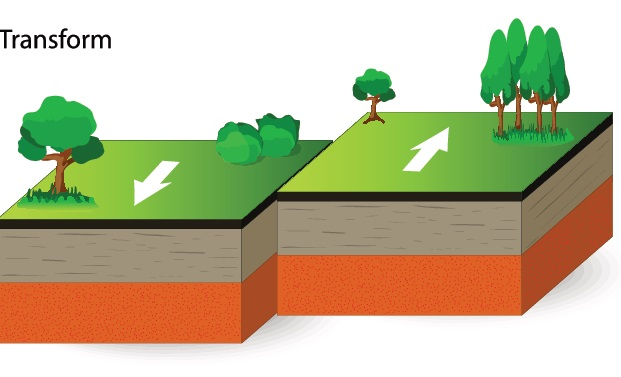
transform
slide past (fault zones and earthquakes)
Alfred Wegner
continental drift theory, found evidence
pieced tg rocks/continents like puzzle
rejected:
wegner assumed earth’s spin plowed oceans (wrong, lacked physics, hypothesis failed
glacial deposits
show up in tropical continents today
places too warm show clear ice age fingerprints
climate fossilization
tropical corals, reefs, and deserts all act as fossils for the past
fossils and matching rocks
split by sea, continental drift
sonar
used to map ocean floor after WWII for nuclear threats, effective for ocean mapping
showed us that mid ocean ridges ring the globe (volcanic seamounts/fracture zones as evidence)
ocean crust
thinner and younger than continental, due to heat flow being highest at ridges where new crust forms
seafloor spreading
magma rises and cools, creating new lithosphere as plates move apart
old ocean crust sinks at trenches (subduction)

magnetic stripes
basalt records the position of the poles as they cool at ridges
heat activates magnetism in these iron rich rocks
record past seafloor spreading
crust density
crust age increases with distance from ridges
sediment thicknesses also increases away from ridges
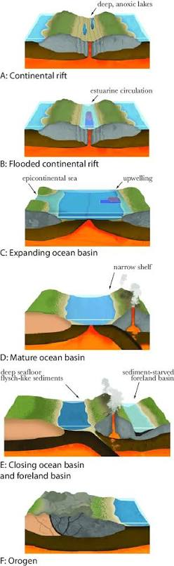
wilson cycle (ocean recycling)
new crust is formed at ridges, while old crust is destroyed in subduction, lifecycle for oceans/continents
rifting
seafloor spreading
subduction
collision
GPS
measures plate movement
hotspot tracks - show movement overtime
plate movement
Stage 1 – a continent stretches
and faults
• Stage 2 – spreading opens a
narrow ocean
• Stage 3 – continued spreading
widens the ocean
normals faults (plate tectonics II)
let blocks drop downward

grabens
the dropped blocks
red sea (triple junction)
arabian, nubian, somalian plates meet 3 diverging boundaries form a triple junction
accretionary prism
sediment is scraped off the sinking plate
sediment piled up (bulldozer pushing a wedge sand)
ocean - ocean subduction
builds island arcs (aleutians)

ocean - continent subduction
builds continental arcs (Andes)

Continent - continent collision
buoyant continental crust resists sinking
- compression folds, faults, and thickens crust | mountain grow (ex: himalayas)