Geol 110 Unit 2
 Call Kai
 Learn
 Practice Test
 Spaced Repetition
 Match
 Flashcards
 Knowt Play
1/108

There's no tags or description
Looks like no tags are added yet.
109 Terms
Mt. St. Helens
Violently erupted in 1980 in Pacific NW blowing down trees and losing 1350 ft of elevation
Viscous
Resistance to flow
What makes violent eruptions?
Si composition, lower temperature, and trapped gas
All three factors play into each other
Effusive volcanic eruption
Mafic, basalt, Hawaii
Erupting constantly
Trapped gas but low viscosity causing lava fountains
Rocks: vesicular basalt (scoria)
Aa and Pahoehoe flow
Aa flow
Jagged, blocky, very sharp
Pahoehoe flow
smooth, ropy, texture
Explosive volcanic eruption
Associated with more intermediate and felsic lava
Composition leads to high viscosity which leads to explosive eruption
High amounts of dissolved gas: H2O, CO2, SO2, H2S
Have eruption column
Eruption column
Huge column of smoke/gas formed when dissolved gas escapes
Forms pyroclastic rocks
Pyroclastic rocks
Rocks formed from hot ash cloud
Classified based on size of pyroclastic material: volcanic ash, lapilli, volcanic bombs
Dissolved gas
under pressure gas dissolved, once pressure released gas forms bubbles and escapes liquid
Types of volcanoes
Shield volcanoes, and stratovolcanoes
Shield volcanoes
Form from mafic lava (basalt)
Very large laterally and vertically
low relief/slope
forms from the repetitive eruption and flattening of basaltic lava
Ex. Hawaii
Tallest mountain from base to height
Mauna Loa
Dome volcano
Tallest mountain in the solar system
Olympus Mons
Shield volcano
Stratovolcanoes
Forms from intermediate lava (andesite)
High verticality but not as large laterally
Steeper sides
Form from intermediate lava flow making cone shape then pyroclastic layer on top repeated
Ex. any south American volcano and Pacific NW Mountains
Volcanic environmental hazards
Pyroclastic flow, lahar, ash cloud, volcanic gas emissions, and tsunamis
Pyroclastic flow
occur at stratovolcanoes
eruptive column made of hot ash and gas state rock
dense, comes “flowing” down the mountain
Deadly
Lahar
Both strato and shield volcanoes
rising magma melts snow causing water to flood carrying ash and debris in massive landslide
Ash cloud
Mainly strato
Some pyroclastic rocks too fin to settle, gets into atmosphere as ash cloud
impacts air travel, agricultural and repiratory problems
Volcanic gas emissions
Both shield and strato
Emit more CO2 and SO2 than all humans combined
May have helped start climate change and extinctions in the past
Can also have localized deaths due to desner SO2
Tsunamis
Underwater/coastal volcanoes can cause tsunamis if they release a lot of materials
Alfred Wegener
1915 proposed theory of continental drift
Didn’t provide mechanism for movement so was disregarded
Continental drift
continents moving over time, not stable, once part of Pangaea
Evidence for continental drift
FIt: continents look like they fit together
Identical fossils across fit
Identical and unique mountain ranges across fit
Rocks in current location could not have formed in that environment of deposition (swamp rocks in Appalachia and glacial rocks in Africa)
What technology developed out of WWII
Nuclear fision — gave info on isotopic dating
Sonar — sea floor mapping
Mid Ocean Ridges (MOR)
Semi linear chain of mountains down center of ocean. Generally follow shape of coastlines. Lava erupting in the center with symmetrically older rock on either side of ridge
Mechanism of continental drift
Sea floor spreading
found 1950s-60s
Theory of plate tectonics
Earth’s crust made up of series of individual plates that are constantly moving and interacting
Low movement (few-10 cm per year)
Interactions at boundaries responsible for geologic events
Types of crust
Oceanic crust (10 km thick) basaltic, dense
Continental crust (40 km), granitic, less dense
Asthenosphere
Fluid toothpaste layer plates sit ontop of (semi-fluid)
Lithosphere
Crust and upper mantle (solid/rigid) that makes up plates
Types of plate boundaries
Divergent, convergent, and transform
Divergent plate boundaries
Plates move apart and new seafloor is created
Mostly in the ocean, MOR
Oceanic vs oceanic
Continental vs continental only in East African Rift Valley
Mainly small earthquakes and volcanoes
East African Rift Valley
Continental vs continental divergent plate boundary
continents splitting creating valley
severe volcanoes and earthquakes
Convergent plate boundaries
Plates move together, can create mountain belts or recycle oceanic lithosphere
Can be oceanic vs oceanic, oceanic vs continental, or continental vs continental
Major earthquakes and volcanoes
What slab subducts at convergent plate boundaries
The oceanic slab (in o vs o the older oceanic slab) because of its greater density
Oceanic vs oceanic convergent plate boundaries
Japan and pacific isles
Older slab denser due to it being hydrated
Oceanic vs continental convergent plate boundaries
West coast of America
Oceanic palte subducts
Continental vs Continental convergent plate boundaries
Himalayas and alps (rare)
Less subduction more one slab rafting over other
large plateau and mountains
few to no volcanoes
Transform plate boundaries
Plates grind past each other
mainly oceanic vs oceanic or oceanic vs continental
major earthquakes, no volcanoes
What causes plates to move and stop moving
Convection in the mantle
Earthquakes
Energy released in the Earth that leads to ground shaking
most common release is pressure between two blocks at palte boundary
energy builds up over time from palte movement (only at plate boundaries or past boundaries)
smaller earthquakes before and after
Fault
plane of breaking
seismometer
how we measure earthquake intensity and location
pen tip stays still while rest of earth moves


Primary waves (P)
compression waves that travel through all materials and travel very fast
Secondary waves (S)
Sheer waves that only travel through solid materials
while slower than p waves still pretty fast
Body waves
S and P waves
Surface waves
Travel in rock layers just below Earth’s surface
Occur when body waves reach Earth’s surface and propogate
Cause greatest destruction but travel the slowest
Earthquake detection
Time interval between P and S waves tell distance from Earthquake which can then be used to triangulate position of Earthquake
Earthquake intensity scales
Mercalli intensity scale and Richter magnitude scale
Measurements of earthquake size
Intensity: observing property damage to estimate amount of ground shaking
Magnitude: use data from seismograph
Mercalli intensity scale
Measures earthquake intensity based on observed damage
Sale from I to XII
I nothing really felt except in very specific circumstances
XII damage total, visible waves
Helpful for past earthquakes
Richter magnitude scale
Data driven, based on highest amplitude of seismograph
Logarithmic scale
Millions of small magnitude Earthquakes occur per year while maybe one high magnitude will occur per year
Earthquake destruction
Actual earth shaking doesn’t kill people, rather resulting secondary effects do.
Damage dependent on earthquake intensity as well as construction of buildings
Worst material for Earthquake buildings
Masonry
Best material for earthquake materials
Steel
Why do less developed countries typically have more deaths due to earthquakes
Buildings less codified and more often built from masonry resulting in greater damage and deaths
Liquefaction
When the soil turns to quicksand as a result of ground shaking
destroys buildings regardless of composition
Tsunamis
Earthquake in ocean forms a long wavelength but short amplitude wave on waters surface
Radiates away from epicenter at 100s of mph
Gets close to shore where it experiences more drag causing wavelength to shrink and amplitude to grow, pulling water away from shores
Total global water
oceans 96.5%, saline lakes and groundwater 1%, freshwater 2.5%
Total global freshwater
glaciers and ice sheets 68.6%, groundwater 30.1%, surface water 1.3%
Total global surface water
snow and ice 73.1%, lakes 20.1%, soil moisture 3.52%, swamps 2.53%, rivers .46%, biological water .22%, atmosphere .22%
Stream
Any water that flows in a channel regardless of size
River
Carries a substantial amount of water
Drainage basin/watershed
the area of land a stream drains
Can have drainage basins within drainage basins
divides
lines dividing drainage basins
sometimes visible as high ridge on mountains
sometimes hard to determine due to topography
Continental divide
a divide that splits a continent into different drainage basins
Rocky mountains in US
Drainage patterns
patterns of interconnected streams in an area
Types: dendritic, radial, rectangular, trellis
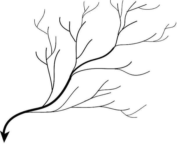
Dendritic drainage pattern
most common
uniform underlying material
Radial drainage pattern
typically forms on volcanic cones or domes
Ex. Adirondacks

Rectangular drainage pattern
bedrock is jointed or faulted
joints or cracks

trellis
bedrock consists of alternating bands of resistant and weak strata
ex. Pennsylvania area

factors effecting flow velocity
gradient and channel shape (wetted perimeter)
gradient
the slope of the stream
steeper gradients have more gravitational energy to drive channel flow
wetted perimeter
area where the river is in contact with the channel
most efficient channels have small wetted perimeter compared to cross sectional area
discharge
how much water is going through a certain point in a river at a single moment of time (ft3 or m3 per second)
measured by propeller in water that measures velocity
best measure of river size
river stage
height of water surface relative to a fixed point
measured by stilling well
Biggest US river
Mississippi river (#8 in world)
Biggest river globally
Amazon river
US Geological Survey (USGS)
measures velocity, discharge, and river stage across 7,500 rivers
gives flood warnings by measuring high stage water in tributaries
Headwaters
start of streams
high gradient, high channel roughness, low velocity
Mouth of streams
end of streams
high discharge and velocity, low slope, low channel roughness
Graph of sediment transportation

How is sediment transported
Dissolved load, suspended load, bed load
Dissolved load
sediment dissolved in water
Suspended load
Fine sediment transported in suspension
clay and silt
Bed load
sand, gravel, and boulders transported by sliding, skipping, or rolling along river bottom
Saltation
bed load transportation by bouncing
alluvial channels
braided and meandering channels
Braided channel
a complex network of converging and diverging channels that thread among numerous islands or gravel beds
form in mountains
large proportion of load is coarse material (bank material easily eroded and reworded)
Stream has high variable discharge
Meandering channel
streams transport suspended sediment in broad sweeping bends called meanders
form in flat areas
relatively deep channels generally transporting mud
Cut bank
where erosion occurs at outside of meander
High velocity
Point bar
where deposition occurs at inside of meander
low velocity
Oxbow lakes
form when erosion connections meandering stream sections and cuts of a meander
meander
broad sweeping bend of a river
flood plain
formed through meandering stream migrating over time
side to side energy flattens floodplain over time
flooding deposits clay making very nutrient rich soil
Natural levee
flooding deposits larger sediments on tip of river bank creating a natural levee due to drastic decrease of velocity upon flooding
sources used for freshwater consumption
75% surface water, 25% ground water