GPS and GNSS
 Call Kai
 Learn
 Practice Test
 Spaced Repetition
 Match
 Flashcards
 Knowt Play
1/50

Earn XP
Description and Tags
Week Seven Flash Cards
51 Terms
What is GNSS
Global Navigation Satellite Systems
Satellite systems that provide positioning, navigation, and timing anywhere on Earth.
Responsible for GPS
Portage Traxx - Snow Removal in Portage
Snow plows use GPS
Links to snowplows to systems within the plow
39,000 miles driven
300 cul-de-sacs (a street, lane, closed at one end)
What is GPS?
Global Positioning Systems
Satellite-based location/navigation system
Provides location and time information anywhere on Earth at any given time
Who was Dr. Gladys West?
Mathematician hired by the U.S. Naval Weapons Laboratory
Developed mathematical models (geoid shape of Earth) and computer programs needed for GPS
Who created GPS?
U.S. Department of Defense
When was the first satellite launched? What happened in 1993?
1978
1993: system complete with 24 satellites
GPS System #1: Space / Satellite segment
Consists of satellites: Two orbits a day, 12,500 mi Alt
Constellation: Fixed positions for optimal/ full coverage, 24 required
Satellites broadcast signals to Earth: position/time sent; L1 = 1575.42 MHz and L2 = 1227.60 MHz are the radio frequencies used to send information; MUST BE OUTSIDE
GPS System #2: Control Segment
Series of ground stations that monitor GPS signals
Relay to master control: Schriever Air Force Base
Monitored; corrections uploaded to satellites

GPS System #3: User Segment
GPS Receivers: Passively receive signals; display location
Receivers: Channels (# of satellites a receiver can communicate with)
Single-frequency GPS
Relies on one radio signal
typically L1 band
Dual-frequency GPS
two simultaneous signals from each satellite to cross-reference and correct positioning errors
L1 and L5 bands
Why did Iran bomb Bahrain?
Targeting the US Navy’s 5th Fleet
Targeting American military installations
The Three Segments of GPS (IMAGE)

What is GPSIII?
Third generation of navigational satellites
Developed by Lockheed Martin for the U.S. Space Force
10 launched, 33 is the goal
Orbital Altitudes of many significant satellites of earth (IMAGE)

Space Junk - 2023
Federal Communications Commission (FCC) issued its first fine for space debris
US TV provider Dish: $150,000 for failing to move satellite into a safe orbit
Why was OCX axed?
Officials believed it put current military and civilian GPS capabilities at risk.
Trilateration
Uses three points of reference to determine where you are

What signals do satellites send?
Almanac: status, orbit, and location
Radio Waves: speed of light
Pseudorange: distance between receiver and satellites
How does the Earth’s atmosphere caused errors in GPS and GNSS satellite signals?
System based on the assumption of unaltered signal transmission to calculate pseudorange (distance between receiver and satellites)
Clock in comparison
SAIT (layer order)

Other GPS-like Systems
GLONASS - Russia; worldwide
Galileo - EU; worldwide (2019)
BeiDou - China, worldwide (2020)
IRNSS - India, regional
QZSS - Japan, regional
GPS: Data Accuracy
What factors impact GPS accuracy?
Atmospheric effects
Sky Blockage
Receiver quality
Higher accuracy is attainable by using GPS in combination with __________
Augmentation systems
Enable real-time positioning to within a few cm, post-mission measurements at the mill level
What is Selective Availability (SA)?
Intentional degradation of GPS signal (time, orbit position)
Discontinued on May 2000 by Pres Clinton
With SA vs Without SA
With: 100 m accuracy
Without: 15 m accuracy
WAAS
Wide Area Augmentation System
Improves GPS position accuracy to under 1 meter!
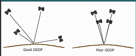
PDOP
Position Dilution of Precision
Error due to undesirable satellite geometry
The lower the PDOP, the better
Atmospheric interferences causes:
Delays
Ionosphere
ionization (neutral atom or molecule turns into a charged particle = ion)
alter speed (5+m error)

Troposphere
water vapor (0.5m error)

What other issues affect GPS accuracy?
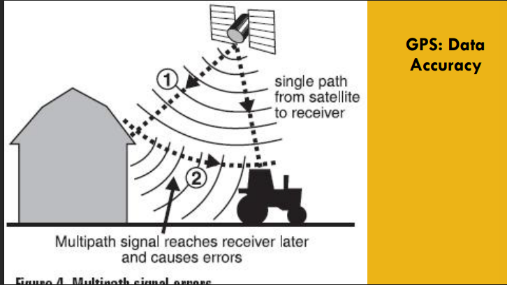
Poor view of the sky
Tree canopy, buildings
Multipath effect
How do I improve accuracy? Differential GPS (DGPS)
Ground-based correction: transmitted to mobile receivers to adjust in real time
Fixed base station: permanent location
Error Detection

How do I improve accuracy? Real-time (direct connection)
NDGPS broadcast: broadcast differential correction signals for accuracy; discontinued
Real-Time Kinematic positioning (RTK): receive signals while in the field

How do I improve accuracy? Post-processing (no direct connection)
Download files from the local base station
Continuously Operating Reference Station (CORS): receives satellite signals and calculates error corrections

How do I improve accuracy? Continuously Operating Reference Stations (CORS)
Constant collection of GPS data for free download
Request the day/hours of data to correct your field data

How do I improve accuracy? Wide Area Augmentation System (WAAS)
USA-only; consists of ground, space, and user segments (stas in geosych orbit)
GPS satellites augmented with WAAS satellites
WAAS-enabled GPS receivers

WAAS system

NDGPS
Nationwide Differential Global Positioning System
Ground-based navigation and positioning network
U.S. Coast Guard / U.S. Department of Transportation
Improved standard GPS accuracy
GPS Receivers
Recreational Grade
Mapping Grade
Survey Grade
Recreational Grade: 5-20m
No differential; most WAAS-enabled
$100-$400
Mapping Grade 1-5m
Usually post-processing differential
Smartphone accuracy is usually here
$400-$5,000
Survey Grade- under 5cm
Usually real-time differential
$5,000 - $75,000
GPS App: USGS Fault Surveys
GPS stations observe the same satellites to measure positions very accurately.
Distances between stations can be measured within a few millimeters.
Comparing positions over time shows fault movement and strain buildup
GPS App: NOAA: 'Micro-Satellites' will use GPS signals to study hurricanes
measure inner core winds, tracks the transfer of energy
produce more accurate measurements of wind speeds over the ocean
Better storm surge estimates, as the height of the ocean changes with pressure
Time - THE 4TH DIMENSION
GPS satellites contain multiple atomic clocks
100 billionths of a second
Precise time is CRUCIAL for economic activity, like communication systems or power grids
GPS Time: Wireless telephone and data networks
GPS for base station sync
Mobile handsets share limited radio spectrum more efficiently
Digital broadcast radio services use GPS time to ensure radio stations arrive
GPS Time: Business
Time-stamp transactions for records
Major financial institutions use it to set internal clocks for transaction timestamps
Automated systems that track transactions made by a global network
GPS Time: Flight information
The U.S. Federal Aviation Administration (FAA) uses GPS to sync reporting
flight time and location
hazardous weather
GPS Time: Instrumentation
Precise timing for devices over wide geographic areas
GPS timing in seismic monitoring networks enables researchers to quickly locate the epicenters of earthquakes and other seismic events.
GPS Time: Power
By analyzing the precise timing of an electrical anomaly as it propagates through a grid, engineers can trace back the exact location of a power line break.