Ocean Circulation
 Call Kai
 Learn
 Practice Test
 Spaced Repetition
 Match
 Flashcards
 Knowt Play
1/23

There's no tags or description
Looks like no tags are added yet.
24 Terms
Earth's Energy Imbalance
Ocean currents also transport heat to ______ latitudes
higher
Surface Currents & Wind
______: flowing band of water
_______ _______: exist at the surface of the ocean, down to depths of 100-400m (330-1,300 ft)
Atmospheric winds "push" surface waters because of ______ _____
Continents ______ currents
The ______ ______ is responsible for the circular patterns
Current; Surface currents; frictional drag; deflect; Coriolis Effect
Gyres
Major surface currents display circular paths in each ocean basin/hemisphere
The circular currents are called _______
Gyres are controlled by global _____, Earth's _______, and Earth's _______
The rotation, clockwise (CW) in the _______ _______ and counterclockwise (CCW) in the ______ _______ is due to the Coriolis Effect
There are 5 major gyres:
North Pacific (_____)
South Pacific (_____)
North Atlantic (_____)
South Atlantic (______)
Indian Ocean (_____)
gyres; wind; rotation; landmasses Northern Hemisphere; Southern Hemisphere; CW; CCW; CW; CCW; CCW
Eddies
Flow within and along _____ currents creates ______ swirls called eddies
_______: small, circular, temporary currents that form at the boundary of a surface current and relatively still water along it
Their _______ can be hundreds to thousands of km
Help to mix the top ~_____m (~300 ft) of the ocean
larger; smaller; Eddies; circumference; 100

A: ______
B: ______
C: _______
Wind; Surface current; Net water transport
Ekman Spiral
Just like there is friction between wind and the surface of the ocean, there is ______ between layers of water
______ applies a shear force to the surface layer, which applies subsequent, though lower-magnitude, shear to the layer below it
The motion is deflected by the ______ ______
Each subsequent layer rotates ______ than the layer above it
Frictional drag ______ with depth
This _____ ______ can be observed in the first ~100 m (328 ft) of the water column
friction; Wind; Coriolis Effect; more; dissipates; Ekman Spiral
Ekman Transport (Net Water Movement)
Considering all the layers together, the net movement of surface water is _____ degrees deflected from the wind direction because of the ____ _____
This water movement is called _____ ________
The deflection direction is dependent upon _____ because it's controlled by the _____ _______
_____ _______: 90 degrees to the right
______ _______: 90 degrees to the left
90; Ekman spiral; Ekman transport; hemisphere; Coriolis Effect; Northern hemisphere; Southern hemisphere
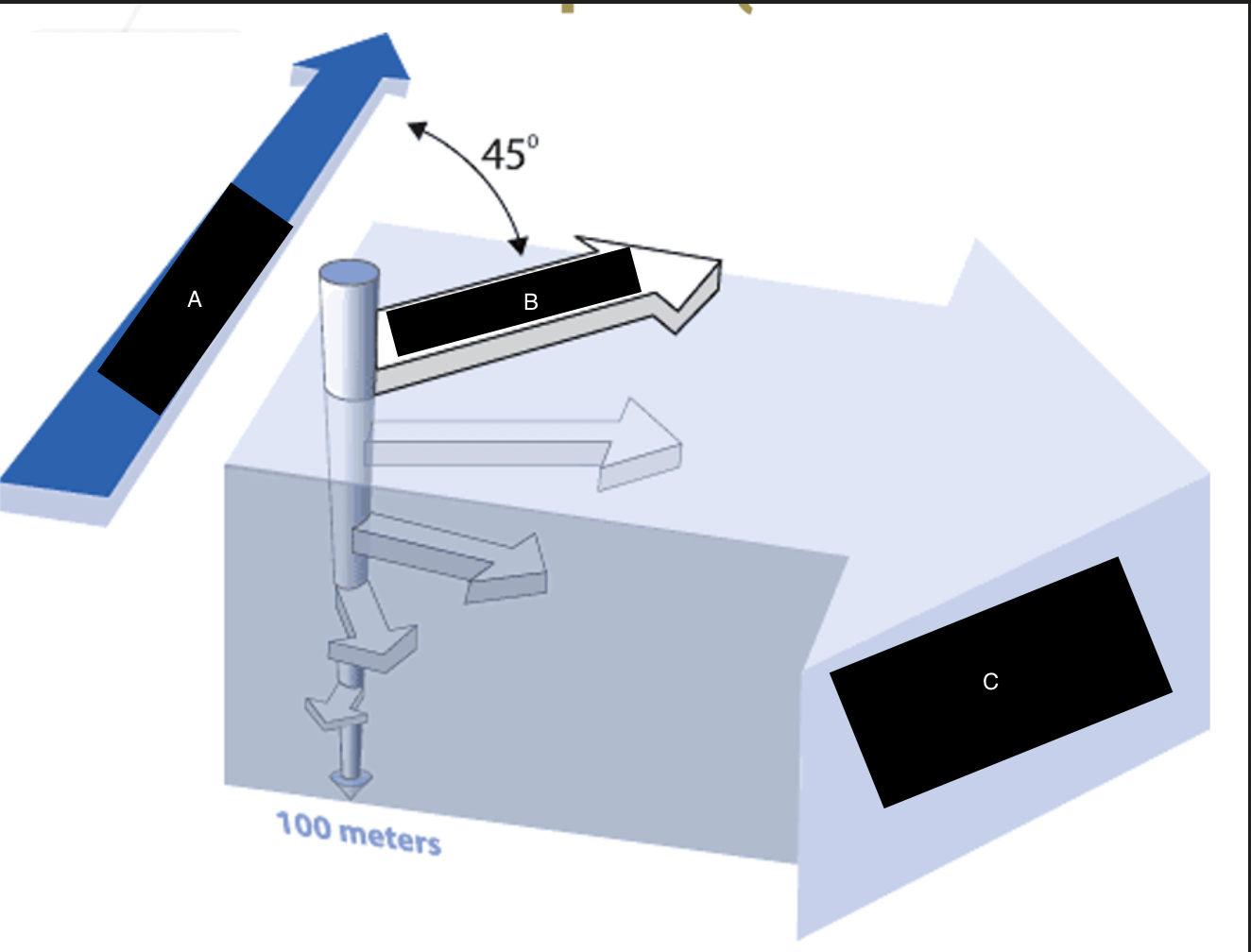
A: _______
B: _______
C: _______
Wind; Surface current; Net Water transport
______ _______ ______ (OST): height of the sea surface referenced against the geoid (an idealized ellipsoid that has equal gravitational pull)
Measured by _______
Variations in OST are created by _____ ______
Tides and waves ______ included in the OST calculation
The highest elevation is found in the _______ part of an ocean
Ocean surface topography; satellites; surface currents; aren't; western
Geostrophic Flow
Ekman transport pushes water to the _____ of each gyre, creating a ~_____ m (3 ft) topographical high
Thus, the ______ ______ pushes water toward the center of a gyre
Water naturally flows from ____ to _____; this force is the pressure gradient
When the ____ (Coriolis) and ______ (pressure gradient) forces become equal and opposite, ______ ______ is achieved
When geostrophic balance is achieved, geostrophic current flows ________ to the slope, with stronger slopes developing _____ currents
______ currents can be assumed to be geostrophic, but _______ currents may not achieve geostrophic balance
center; 1; Coriolis force; high; low; inward; outward; geostrophic balance; perpendicular; strong; Large; smaller
Convergence & Divergence
Ekman transport pushes water:
_____: net inflow of water in an area (water masses move towards each other)
______: net outflow of water in an area (water masses move away from each other)
Ekman transport results in:
_______: convergence at the center of a gyre excess water moves down
_______: divergence outside of the gyres, creating a void where water can undergo this to fill the gap
Convergence; Divergence; Downwelling; Upwelling
Great Pacific Garbage Patch (GPGP)
Plastic is _____ dense than water, so when water ______ at the center of gyres, plastic remains ______ at the surface
_______ ______: high accumulations of ocean plastic, usually in the form of microplastics
less; downwells; floating; Garbage patches
Microplastics
< ____mm long
______ _______: released directly to the environment as small plastic pieces
______ ______: form from the breakdown of larger plastic items
Plastics never totally break down
Over _____ million tonnes of microplastics have accumulated on the world's ocean floor
16-35% of microplastics in the global ocean come from ________ _______
The _____ of textile-sources microplastics are released in the first few washes. Fast fashion is a particular problem because these garments account for a high number of first washes
5; Primary microplastics; Secondary microplastics; 14; synthetic textiles; majority
Cargo Ship Accidents & Ocean Current Mapping
_____: goods accidentally lost from ships at sea
______: materials intentionally discarded from ships at sea
Tracking flotsam allowed oceanographers to map the speed and trajectory of _____ _____
1990: 61,000 Nike shoes, each with a unique serial number, "The Great Shoe Spill of 1990"
1992: 29,000 plastic bathtub ducks & other toys
1994: 34,000 ice hockey gloves
Flotsam; Jetsam; ocean currents
Downwelling & Upwelling Along Coastlines
Upwelling and downwelling occur at ______ when water is deflected due to _______ ______
When water is deflected toward a coastline, _______ occurs
When water is deflected away from a coastline, ______ occurs
It's not just water that is transported - nutrients, oxygen, salt, and contamination move with the water
coastlines; Ekman transport; downwelling; upwelling
Coastal Upwelling
_______ brings cold, nutrient-rich water to the surface when Ekman transport creates a water deficit
Areas where upwelling occurs often have _____ biological productivity
Upwelling; high
Upwelling and Biological Productivity
_______/Microscopic Algae: base of the marine food web
Flourish when ______ nutrients are present
Coastal upwelling brings nutrients from _______ waters to the surface, making them accessible to _______ producers
Phytoplankton; abundant; deeper; primary
Water _____ is a function of temperature and salinity
Denser (colder, saltier) water _____
_____ dense (warmer, fresher) water is buoyant and rises
The rising and sinking of water due to density creates a global flow pattern called ______ ______
Thermo = ______
Haline = _____
This global conveyor belt of ocean water takes about ______ years to complete a cycle
density; sinks; Less; thermohaline circulation; temperature; salt; 1,000
Water Masses & Deep Water Formation
_____ _____: a volume of seawater that has a distinct density due to its particular salinity and temperature
Properties of a water mass don't change easily once they move away from the ______
Water masses don't _____ well because of these distinct densities and properties
In some areas of the globe, conditions at the surface can lead to water becoming ______, which can cause water masses to sink
Water mass; surface; mix; denser
Atlantic Meridional Overturning Circulation (______): refers to the part of thermohaline circulation that operates within the Atlantic Ocean basin
Research indicates that AMOC is _____ due to climate change, which includes warming oceans, increased rainfall, and melting sea ice
AMOC may have slowed up to ____ since 1950
AMOC has totally ______ (collapsed) in the past, for example during ice ages
AMOC; slowing; 15%; stopped
_____ _____ (T-S diagrams): used to identify water masses
T-S diagrams have curved lines of equal _____
5 major water masses in the Atlantic Ocean:
North Atlantic Central Surface Water (_______)
Mediterranean Intermediate Water (_____)
Antarctic Intermediate Water (______)
North Atlantic Deep Water (______)
Antarctic Bottom Water (______)
Temperature-Salinity Diagrams; density; NACSW; MIW; AAIW; NADW; AABW
______ _______: flow along contents at the eastern and western edges of ocean basins
Eastern/western refers to the location within an ______ ______ (not continental landmass)
_____ ______ _____: flow in the western part of an ocean basin, moving warm water to the poles
Stronger due to the _______ ______
The Gulf Stream is a ______ Boundary Current
______ _______ ____: flow in the eastern part of an ocean basin, moving cold water toward the equator
Boundary Currents; ocean basin; Western boundary currents; Coriolis Effect; Western; Eastern boundary currents
Comparing Eastern and Western Boundary Currents
Western boundary currents tend to:
Be ______ than typical surface currents (down to 1,000 m (3,000ft))
Deflected by the _______ _______, don't flow onto the shallower continental shelf
Move _______, 40 - 120 km (25-75 mi) per day
Ex: Gulf Stream, Kuroshio Current, East Australian Current, Brazil Current, Agulhas Current
Eastern boundary currents are:
Slower
Shallower
______
Ex: California Current System, Peru-Chile Current, Canary Current, Beguela Current, Leeuwin Current
deeper; continental margin; rapidly; Wider
Antarctic Circumpolar Current
Driven by strong ______ winds
Exists because no _____ blocks the flow of water, so a strong current of water encircles Antarctica
The ______ _______, between South America and Antarctica, is the roughest patch of ocean on Earth
It’s the _______ (190 km (120 mi)) and deepest (down to 4 km (2.5 mi)) surface current
Its presence _________ warm water from the Atlantic, Pacific, and Indian Oceans from mixing with the cold water around Antarctica. This helps to maintain Antarctica's cold climate and therefore, its ice sheets
Cold water ________ from the Antarctica's continental shelf to form Antarctic Bottom Water (AABW)
This powers _______ _______
westerly; land; Drake Passage; widest; prevents; descends; thermohaline circulation