GEOG 1 - Midterm 1 Study Guide
 Call Kai
 Learn
Learn Practice Test
 Spaced Repetition
 Match
Match Flashcards
 Knowt Play
1/29

There's no tags or description
Looks like no tags are added yet.
Name | Mastery | Learn | Test | Matching | Spaced | Call with Kai | Chat |
|---|
No analytics yet
Send a link to your students to track their progress
30 Terms
Lec 1: Why does scale matter and how do we illustrate scale on a map?
Scale can be used to misrepresent data and everything is related to what it is being compared to.
Large scale + Small scale
Lec 1: What are the earth’s spheres?
B.L.A.H
Biosphere
Lithosphere
Atmosphere
Hydrosphere
Lec 1: Distinguish between human and physical geography sub-field.
Human: cultural, economic, political, urban, health, demography/population
Physical: hydrology, climatology, meteorology, geomorphology, biogeography, pedology
Lec 2: Describe the main components of a GPS, what it measures, and how it operates.
Main components: Satellites, ground stations, receivers
Measures: ping time to receiver - distance, speed, elevation
Operation: Multilateration/Trilateration where multiple satellites find your location. Di
Lec 2: What data does each individual satellite collect from your receiver?
Distance ONLY
Lec 2: Who owns satellites and how have they changed society?
Navstar, Galileo, GLONASS, BeiDou, IRNSS.
More accurate travelling through GPS.
Korean Air Flight 007: Flight from New York to Seoul killed 269 on board due to trespassing USSR territory.
Lec 3: The differences between the Mercator and the Gall-Peters projections and what types of distortion each one creates.
Mercator: messes with area/size but preserves shape well.
Gall-Peters: Equal area projection
pro: area preserved
con: shape heavily distorted
Lec 3: What are the different ways in which maps are political?
Benefits someone and disadvantages someone else.
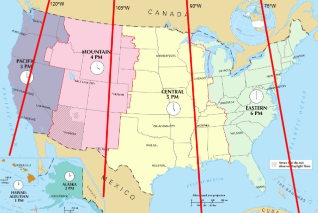
Lec 3: What was the rationale for how time zones were created?
1 - Earth Rotates 360 degrees every 24 hours
2 - 360/24 = 15 degrees of rotation an hour
3 - So each time zone is 15 degrees

Lec 4: Parallels/Meridians and where they are specifically located.

Lec 4: Name solstice/equinox dates and how they correlate with the sun and seasonality.
Summer Solstice
June 20-21
Longest period of daylight
Peak of sun rays on Tropic of Cancer
Continuous daylight above Arctic Circle
Winter Solstice
December 20-21
day with shortest period of daylight
Peak of sun rays on Tropic of Capricorn
Continuous daylight below Antarctic circle/continuous darkness above arctic circle
Spring & Fall Equinox
March: spring equinox (north) , fall equinox (south)
September: fall equinox (north) , spring equinox (south)
day with equal day/night
Lec 5: What causes the sky to turn different colors throughout the day?
Light collides with air particles in the sky.
If there was no atmosphere, there would be no colors.
Lec 5: What is the gaseous composition of the atmosphere?
78% nitrogen
21% oxygen
1% argon
traces of CO2 and H2O
Lec 5: What causes the Aurora Borealis and what is occurring?
Cause: Solar wind electrons enter the atmosphere and collide with air molecules → Molecules become unstable, releasing photons (tiny particles of light)
Occurring: oxygen molecules (green), nitrogen molecules (red & blue)
Lec 5: What is happening during temperature inversions and which features cause them to occur?
Cool air and pollution are trapped near the ground
valleys
coastal regions
snow

Lec 6: How is air pollution measured?
Air Quality Index (AQI)
Ozone: gas that damages respiratory tissues when inhales
Particulate Matter (PM2.5): fine particles in the air that enter the lungs and bloodstream

Lec 6: What main factors determine climate/temperature variability between different places?
Lec 6: How do altitude/elevation correlate with air pressure and air temperatures?
The higher the elevation, the lower the air temperature.
Lec 7: How is water used in direct and indirect ways?
Direct (what you can see): toilets, bathing, cooking, drinking
Indirect (what you can’t see): water expenditure to produce food
Lec 7: What influences local humidity rates? How does humidity impact how we feel?
Hot coastal places tend to be more humid than cool places → heat causes faster evaporation from oceans
Low Humidity: low moisture, dry air, sweat evaporates quickly, heat drawn away from body, cool down/feel great
High Humidity: more moisture, wet air, sweat evaporates slowly, sticky/sweaty
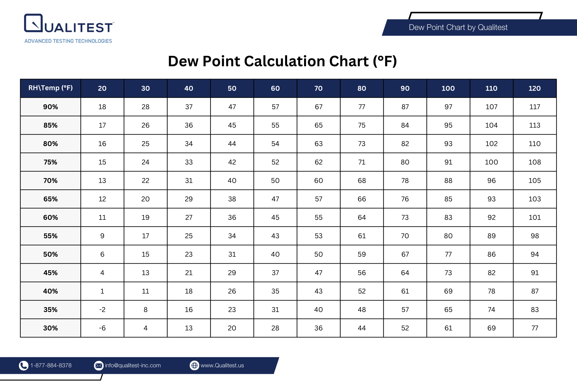
Lec 7: How do you read a Dew Point chart?
Lec 8: Why is the ocean salty?
rain dissolves minerals from rocks → rivers carry them to the ocean → as water evaporates → salt remains → gradually making seawater about 3.5% salt

Lec 8: How do the sun and moon relate to our tides? Which has a stronger gravitational pull?
(1) Moon and Earth gravitate toward each other
(2) Water on Earth bulges toward the moon
(3) Side of Earth not facing the moon tides the opposite way
The moon has 2x the amount of gravitational pull.
Lec 8: What causes certain lakes to become endorheic?
Lec 8: How do the phases of the moon correlate with certain tides?
Lec 9: Why are rivers difficult to measure? What causes them to meander?
Difficult to measure because they are always changing.
Causes:
Initial disturbance
Curved Erosion
Time
Slingshot Effect
Lec 9: How has California’s coast changed since the last Ice Age?
Lec 9: How have we modified our Delta in the last 200 years?
Lec 9: What are exotic and non-exotic streams? How does this impact their water discharge rate?
Exotic: streams that originate in humid regions and flow through arid regions (“exotic” = foreign origin)
Non-exotic: