EARTH 444: Wetlands
 Call Kai
 Learn
 Practice Test
 Spaced Repetition
 Match
 Flashcards
 Knowt Play
1/113

There's no tags or description
Looks like no tags are added yet.
114 Terms
core indicators of a wetland
hydrology - water at or near surface long enough to shape environment
hydric soils - lox oxygen, gleying, or mottling
hydrophytes - plants adapted to saturated oxygen-poor conditions
UN wetland definition
marsh, fen, peatland, water, natural or artificial, permanent or temporary with water that is static or flowing, fresh, brackish, or salt including areas of marine water, the depth of which at low tide does not exceed 6 metres
made 2000 RAMSAR sites
canadian wetland definition
Land that is saturated with water long enough to promote wetland or aquatic processes as indicated by poorly drained soils, hydrophytic vegetation and various kinds of biological activity which are adapted to a wet environment
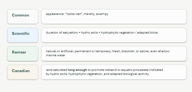
why definitions matter
what gets counted, where are boundaries, which get protected?
Ontario Wetland Evaluation System changes
evaluated separately as opposed to in a complex, not protected
plus less SAR importance and MNR no longer has final say so overall less provincially significant wetlands :(
wetland class diagram
category, class, form (surface, soil and water), type (dominant vegetation)

mineral wetlands
<40cm organic material, mineral soils w low O, Fe, and Mn. Grey-blue gleyed soils
marsh, swamp
organic wetlands (peatlands)
>40cm organic material
dead partially decomposed plant material
bog and fen
bog
raised above surrounding terrain w water at or just below surface. Ombrogenous (water only from precipitation falling on top (not runoff either)), old, mossy and shrubby, low productivity and diversity. More acidic and less minerals. pH 3-5
Fen
Minerogenous (groundwater and SW w minerals), graminoids grasses/sedges and shrubs. pH 5-7. More nutrients and diversity.
where are bogs and fens in Canada
boreal areas, interspersed w forest. South central Canada
swamp
mineral or organic, minerogenous, water table below surface w dry hummocks, seasonally flooded, high P, trees! (cedar, maple, black ash)
marsh
mineral soils w some peat, minerogenous, shallow surface water, herbaceous vegetation, floating plants, lots of nutrients and P and biodiversity! v commin in SO
shallow water wetland
open water >75%, mineral soil. ponds, potholes, estuaries. may dry up. not including our reservoirs
canadian wetland classes diagram

wetland continuum
between lake and upland can be marsh and swamp, boundaries v gradual

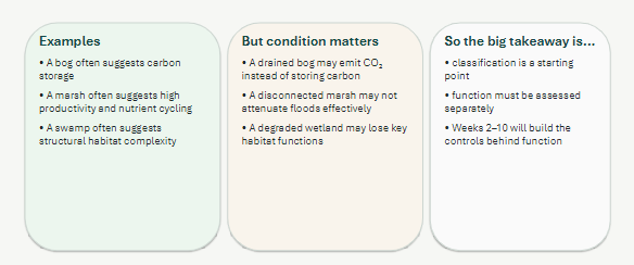
why is class a CLUE of function
presence DNE function. hydrology, soils, and vegetation, chemistry, and disturbance determine what it actually does
core 4 ecosystem services
provisioning (food, peat harvesting)
regulating (flood mitigation, aquifer recharge, filtration)
cultural (aesthetic, recreation)
supporting (nutrient cycling, photosynthesis)

how wetlands matter differently
theoretical potential (type, size) leads to actual performance (depending on hydrology and soil) leads to social value (what does it actually do and for who)
main drivers of wetland loss
agriculture, pollution, development, alteration, roads, channelization, mining, and climate change
mostly small upland ones than large riverine
functions of a wetland
biological condition informs hydrologic (like storage) and water-quality (like nutrient retention) function
4 types of wetland intervention
restoration, creation, enhancement, treatment
artificial vs human-induced wetland
only if persistent and continuous human activity vs
one time action by humans lead to persistent, functioning wetland
what is no net loss policy?
developers can get rid of wetlands as long as they make new ones in the same proportion. 2:1 mitigation ratio means 2ha created for every 1 lost
we can compare restoration success against
baseline (what was lost)
reference (similar ecology or function)
good success criteria
specific
measurable
linked to goals
sensitive to time scale
compared to appropriate benchmark
steps for site selection
easier to restore
look at land use, check hydrology, go where inundation frequent, characterize soil, and chemistry of water sources
local seed banks, materials, ownership, corridor for animals, access, and size
tile drains
need to make sure water won’t just leave wetland if constructing. these are tubes in agricultural soil to drain in spring, may need to be blocked if making wetland and good to be in depressional area
riparian wetlands
can be dried out if concrete channel, need to let river reconnect to floodplain and meander
get lots of runoff and snowmelt and interact w gw
can’t be a bog
top 2 drainers of peatland
agriculture and forestry
steps of peatland drainage
also more vulnerable to drought, change run-off & chemistry, loss of vegetation, and decline of peat surface

steps of peatland restoration
REWET PEAT - raise wt and block drainage and erosion
STABILIZE PEAT - reprofile, protect surface
RESTART FORMATION - spread mulch and introduce plants
salt marsh
mid-high latitude, equal sediment accumulation and subsidence, medium waves
tidal flooding, salinity, permeability and N-limited
salt-tolerant grasses and rushes
INTERTIDAL, SALINE, SEDIMENT- AND TIDE-DRIVEN
freshwater tidal marsh
TIDAL BUT FRESH, CONNECTED TO ESTUARIES
inland along tidal rivers
salt and inland mixy
more plant diversity and bird use bc less salt
near human centres :(
mangrove swamp
WARM-CLIMATE INTERTIDAL FOREST SHAPED BY TIDES AND GEOMORPHOLOGY
tropical and subtropical
replace salt marshes where it’s warm
mangroves love salt
depend strongly on hydrology and geomorphology
ecosystem services of mangrove swamps
tropical coasts! roots stabilize sediment and exchange gas (pneumatophores)
supports fisheries
COASTAL PROTECTION, HABITAT, CARBON, WATER/SEDIMENT REGULATION, PEOPLE AND LIVELIHOODS
why mangrove planting can fail (4 reasons)
wrong place - have mangroves been there historically?
wrong conditions - too much flooding or salt or erosion
wrong ecology - wrong species, monocultre
wrong social setting - people don’t gaf
controls on mangrove establishment
hydrology (flooding and drainage)
geomorphology (elevation, slope, sediment)
disturbance (waves, grazing, erosion)
propagule (can seeds get there?)
why mangroves were bad in hawaii
not supposed to be there! altered mudflats and bird habitat
trapped sediment and obstructed waterways
invaded fishponds
issues with Prime Hook salt-marsh
lots of storms, altered hydrology w construction, saltwater came in by accident, marsh becoming open water, vegetation lost
prime hook restoration
tidal channels - reopened exchange and dredged where drainage would usually be
marsh platform - raised elevation w sediment, rebuilt shoreline, helped vegetation return
recovery support - grass plugs, monitoring, adaptive management

three restoration responses

two conditions for wetland formation
water source and retention mechanism (low permeability, depression, poor drainage)
NEEDS BOTH! so good in N bc less evap, glacial melt, fine glacial till, and glacial depressions
rule of thumb for wetland location in a drainage basin
form at the lowest-energy positions in a drainage basin — where water moves slowest and has time to accumulate
slope sleep (geomorphological control along w depression)
gw reaches surface at break in slope

kettle wetland “prairie pothole”
NA prairies from glaciers, many lost to agriculture
sww or marshes, may dry in summer
how biota alter hydrology (beaver, sphagnum, marsh, trees, geese)
beaver - blocks outflow → raises hydroperiod → creates shallow water/marsh
Sphagnum / peat builds peat → raises surface → isolates from mineral water
Marsh vegetation slows flow → traps sediment → shallower basin
Trees increase transpiration → lower summer water levels
Muskrat / geese remove vegetation → open water and altered flow paths
4 key hydrologic characters of a wetland
water levels (table and h), hydroperiod & pattern, water residence time, water budget
water table
surface where pore water pressure equals atmospheric pressure. It may lie below the soil surface or rise above
it during inundation.
hydroperiod vs pattern
period is how long and when inundated, strongly influences vegetation
pattern is complete change over time
capillary zone
saturated zone immediately above the water table. Capillary forces hold water under slightly negative pressure.
hydropatterns can be used to infer
1) Permanence and duration of inundation (flooding)
• 2) Predictability (variability)
• 3) Seasonal timing of inundation
• 4) Harshness, extremes in inundation or drought
• All of these will influence the ecosystem that develops in the wetland
• And wetland’s ability to perform flood control, sediment capture
• Sometimes infers water source but not always!
E.g. tides, seasonal river flooding...
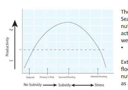
subsidy-stress model
seasonal flooding brings nutrients and sediments in a little boost for higher P
aggressive flooding can remove these things and be a stress
recharge vs discharge wetland
have contribution to gw (output>input)
recieve gw annually (input>output)
rain and runoff can change wetland head quickly and reverse roles where gw reacts slowly because percolation takes time
change in storage deltaV=
water entering (precipitation, gw, runoff) - water leaving (et, surface outflow, gw outflow)
water budget eqn
where T = tidal

why is total precipitation (P) not net (Pn)
because I = interception where some sits on surfaces and evaporates
TF = throughfall sf = stemflow
Vro = surface runoff =
C (coefficient, unitless) x A (watershed area, m2) x P (precip depth, m) = m3 (not mm)
C (runoff coefficient)
depends on watershed! higher for paved or roofed
higher = rapid runoff, less interception, infiltration, and storage
water budget worked example

direct precipitation (Vp)
P x Awetland
Vet
ET x Awetland
change in stored volume (deltaV)
Awetland x (hend-hstart)
average storage-change rate (dV/dt)
dV/days
net GW exchange (Gnet)
dV-Vro-Vp+Vet
impact of more upland trees
more ET, less inundation, less methane (methanogens need anaerobic water), less amphibians
residence time (TR)
avg time a H2O spends in wetland, only easy if in steady state though ☹
Tr = V/Qt
if v is avg volume of storage and Qt is total in or outflow (volume/time)
JUST AN AVERAGE
surface water inflow depth Si
depth that annual volume would create if spread uniformly over the wetland
=annual inflow volume / wetland area
most common outflow by wetland type
bog = ET
fen = ET and runoff
marsh = gw, et, runoff
swamp = et bc trees
wetland soil importance
record hydrologic history, control plants via chemistry, store C and nutrients to cycle, change more slowly than other abiotic factors
can totally change O supply based on saturation
what does organic soil look like?
input>decomp
brown-black, plant fragments, waterlogged, slow decomp
peat formation feedback loop
wet → low O → slow decay → accumulation of peat → more water storage

organic soils can be saturated lots or a little, this changes…
organic carbon content. saturation means <20% OC and not saturation means >20%
also always have more OC than mineral
porosity =
Vv/Vt
higher in organic, super wet in peatlands bc more S
bulk density =
dry weight/total soil volume
higher in mineral soils bc dry is closer to total
porosity and bulk density relationship

behaviour of less decomposed peat
visible plant fibres (fibric), low bulk density (pb), high n, high K, lighter colour
cation exchange capacity (CEC)
how many exchangeable cations soil can hold. H+ gets released and Ca2+ or something binds to neg surface
clay and organic v negative, higher CEC
helpful for plant uptake of ammonium
organic soil has low nutrient availability despite high CEC because…
they’re in organic forms and having so much water stops them from mineralizing. dissolved inorganic (mineral) would be better
why do organic soils have lower pH (more acidic)?
in mineral, carbonates and silicates consume H+ and make things basic
in organic, CO2 from decomp makes things acidic
gw tends to be higher pH than rain
organic matter is usually the electron…
donor. O2 is a good acceptor (gets reduced). more Eo (reduction potential) means more energy yield
what gets reduced in soil in what order!
O2, then nitrate (NO3-), then Mn and Fe, then Sulfate, then Methanogenesis under v reducing conditions
more donor (oxidation) than acceptor (reduction) as O2 runs out quick
why do soils go grey? (gleying)
fe3+ oxide is red, when reduced it goes to Fe2+ and leaves soil matrix
prolonged reducing conditions, where iron was reduced and mobilized long enough ago that soil chemistry has been altered a lot
oxidized rhizospheres
just root holes where a little o gets in causing mottled rust colour in soil
regulators of soil redox conditions
wt fluctuation, e- acceptors and donors, microbial populations, temp, pH
grey and mottled (red) soil means
repeated wetting/drying, wt fluctuation, or root-channel O
soil colour by wetland type

example of open and closed systems
tidal marsh vs dome bog
transformers
no net change of nutrients but change in speciation
top 3 geochemical parameters
pH, redox potential, EC
specific conductivity
dissolved ions carry electrical current through water
uS/cm. carbonate rich gw probably higher than rain-fed bog
redox metabolism
organisms harness e- energy to do work. commonly done by microbes in flooded environments
oxidation state
O very EN, H much less EN (gives e-)
Eo and Eh
More positive E⁰ means a greater tendency to accept electrons under standard conditions. Every half reaction has a corresponding value With the same electron donor, a higher E⁰ of the electron acceptor generally offers a greater energy yield

Gibbs free energy
energy payoff in kJ/mol
dEo = Eaccept-Edonor
dGo = -nDdEo
pos E = -G (releases energy)
n = electrons, F = faraday constant
Eo doesn’t change in this class!

Eh
measures redox potential. higher for oxidized species and oxidized conditions
Eh after flooding
falls bc o eaten up and things become reducing
but other acceptors can keep doing decomp so don’t worry
soil pH after flooding
CO2 lowers pH but reduction can consume H+ so buffering capacity ofen leaves itt at 6-7
impacts on nutrient budgets
seasonal (flood/growth), us/ds connection, soil and sediment storage, humans
P cycling
often as phosphates (dissolved reactive P)
organic, dissolved or particulate
limits p
released from organic in decomp, adsorbs to minerals, sedimented into soils, released in anoxic conditions